
Search for another town


Free U.S. delivery 7 to 10 days after you order
La Presa, California Map Art
Building by building, with labeled streets and shaded relief.
12" x 18" Archival Matte Print
A Map of Home. A Work of Art.
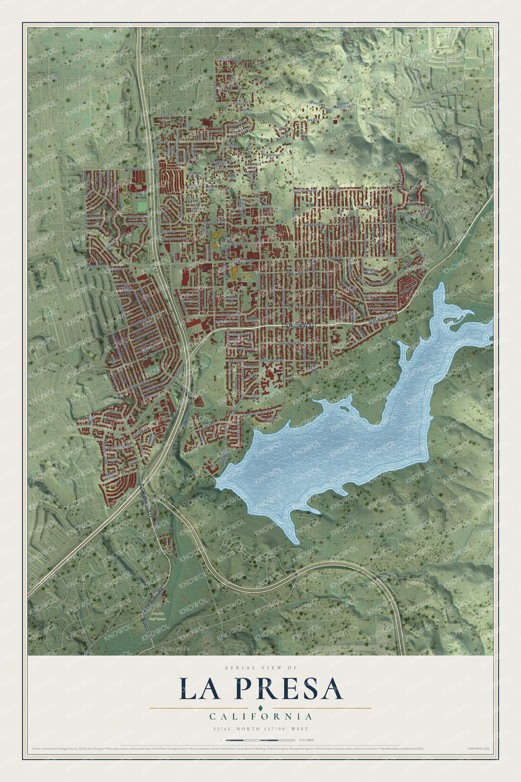
Explore La Presa, California from a whole new perspective. Created using aerial imagery and detailed geographic data, this map captures La Presa building by building, with labeled streets, familiar landmarks, and shaded topographical relief that highlights the natural contours of the landscape.
Combining modern data with the timeless character of a vintage atlas, this map is just as interesting up close as it is beautiful on the wall. Whether you grew up in La Presa, spent memorable years there, or call it home today, this unique map is a great way to celebrate a place that means something to you. Zoom in on the preview to look for your street, and then order a print to put your memories on the wall.
Three ways to hang it

Unframed archival matte, a black wood frame or a white wood frame.
Up close
Geography Worth Displaying
This map was created using accurate cartographic data and authoritative geographic sources, including the U.S. Geological Survey and the Census Bureau. The map brings together terrain, waterways, roads, and building detail. The majority of the streets are labeled, houses are accurately depicted, and the topography is derived from government sources. Combining local data with carefully composed color and shading leads to this beautifully detailed La Presa artwork for your wall.
Rather than simply showing street outlines, we’ve included as many of the street names as we could reasonably fit on the map while keeping their names legible. Zoom in on the high resolution preview to see exactly what’s on the map. We truly set out to create a statement piece for anyone who loves La Presa. So whether it’s for you, or a gift for someone you love, we hope this map of La Presa brings back fond memories.
Read the story behind this map of La Presa, California from 2026.

Find your street
Names on the La Presa map
Every name below is printed on this map. Look for your street, your school, the park where you played, or the pond down the road.
Places and landmarks3
- Bonita Golf Course
- Dictionary Hill County Preserve
- Sunnyside
Streets and roads192
- Sweetwater Road
- County Highway S17
- Jamacha Boulevard
- Bonita Road
- Galopago Street
- Helix Street
- Jamacha Road
- Grand Avenue
- Elkelton Boulevard
- Quarry Road
- Paraiso Avenue
- Ramona Avenue
- Saint George Street
- Maria Avenue
- La Presa Avenue
- Worthington Street
- Carlsbad Street
- Paradise Valley Road
- Parkbrook Street
- Osage Street
- Harness Street
- Kempton Street
- Broadview Street
- Lakeview Avenue
- San Diego Street
- Sacramento Avenue
- Apple Street
- Quarry Trail
- Birch Street
- Maya Street
Show all 192 streets
- Concepcion Avenue
- Felicita Avenue
- Ildica Street
- Walbollen Street
- Orville Street
- Chestnut Street
- Noeline Avenue
- Piedmont Street
- Sweetwater Lane
- Blossom Lane
- Eucalyptus Street
- Presioca Street
- San Bernardino Avenue
- Tyler Street
- Gillespie Drive
- Cuyamaca Avenue
- San Miguel Avenue
- Capistrano Avenue
- Portola Avenue
- Osage Drive
- Date Street
- Pecos Street
- Innsdale Avenue
- San Carlos Street
- Montemar Drive
- Coronado Avenue
- La Mesa Avenue
- Pointe Parkway
- Banock Street
- Tarleton Street
- Darby Street
- Camino Lago Vis
- Sangamon Avenue
- Rosedale Drive
- Valencia Street
- Bluffview Road
- Bancroft Drive
- Brucker Avenue
- Cacus Street
- Leland Street
- Bigford Street
- Avocado Street
- Highview Lane
- Enfield Street
- Thayer Drive
- Canyon Road
- Gowin Street
- Folkestone Street
- Leigh Avenue
- Jacoby Road
- Faxon Street
- Avenue Ricardo
- Akard Street
- Ivanho Street
- Berkview Lane
- Paden Drive
- Outinda Street
- Rangeview Street
- Kelburn Avenue
- Lance Avenue
- Milburn Avenue
- Holt Street
- Jaylee Avenue
- Arapaho Street
- Via Tapia
- Safford Avenue
- Stansbury Street
- Elkelton Place
- Hotz Street
- Vecino Court
- Ivy Lane
- Ivy Street
- Rinda Lane
- Ruxton Avenue
- Crofton Street
- Pso Iglesia
- Alene Street
- Frederick Street
- Clamath Street
- Tokaj Road
- Potrero Street
- Lechuza Lane
- Oso Road
- Avon Lane
- Helix Court
- Nina Court
- San Francisco Street
- Sweetwater Res Road
- Buena Vista Avenue
- Purdy Street
- Delrose Avenue
- Verde Ridge Road
- Arran Avenue
- Avenue Angulia
- Cír Margen
- Spring Vista Way
- Lemon Street
- Valencia Lane
- Knob Hill Drive
- Luther Drive
- Christiana Street
- Crestmore Avenue
- Avenue Colino
- Dorchester Street
- Ashmore Avenue
- Jaeger Road
- Spencer Mountain Road
- Vista del Oro Way
- Berkwood Drive
- Avenue Acero
- San Juhn Street
- Terrakappa Avenue
- Avenue East
- Cambon Street
- Hiel Street
- Brampton Street
- Lake Breeze Court
- Kelso Street
- Jamacha Lane
- Wolford Drive
- Hawkins Way
- Central Avenue
- Helix Place
- Jana Court
- La Larga Vis
- Water View Court
- Gremlin Way
- Helix Vista Drive
- San Miguel Street
- Rudy Road
- Langdon Lane
- Redfield Street
- Maynard Street
- Rover Street
- Glen Vista Street
- Clytie Lane
- Galeon Court
- Felicia Lane
- Joan Street
- Amys Street
- Piel Place
- El Pasillo Lane
- Terracina Circle
- Eileen Street
- Saint George Place
- North Slope Terrace
- Colbert Drive
- Barneveld Street
- San Andres Street
- Tyler Court
- Smokey Lane
- Coushatta Lane
- Vallata Lane
- Loma View Court
- Brady Avenue
- Cameron Drive
- Lang Avenue
- Mesa View Way
- Ildica Way
- Washington Street
- Janice Street
- Corte Pato
Names are listed as they appear on the printed map. Zoom into the product photos to find them.
About La Presa, California
La Presa is a community of 35,033 people in San Diego County, in the East County region a few miles east of San Diego. Its name is Spanish for "the dam," and it was named after Sweetwater Dam. For two decades the Census Bureau counted it as part of its neighbor, Spring Valley, and many residents still use that name for their home.
- Named for Sweetwater DamLa Presa takes its name from Sweetwater Dam. In 1914 the book Spanish and Indian Place Names of California translated La Presa as the dam or dike and placed it on the Sweetwater River, a few miles east of San Diego.
- Part of Spring Valley until 1990La Presa was counted inside Spring Valley through 1990 before becoming a separate place. Many people still treat it as part of Spring Valley in everyday talk. Its addresses still use the Spring Valley name, and the Postal Service lists its 91977 ZIP Code under Spring Valley.
- 35,033 people in 2020The 2020 census counted 35,033 people in La Presa, up from 34,169 in 2010. The community covers 6.0 square miles, and 0.5 square miles of that is water.
Keep exploring California
La Presa is one of 1,990 California towns we've mapped. Every dot on the map is a print of its own.
The search covers every state, California first.
Near La Presa
Order 2 or more town maps and save 10%. Shown in the size and finish you picked above, so they hang as a set.
- Spring Valley 12" x 18" / Archival Matte Print $39.99
- Lemon Grove 12" x 18" / Archival Matte Print $39.99
- Bonita 12" x 18" / Archival Matte Print $39.99


More maps nearby: Bay Terraces, Encanto, O'Farrell, Alta Vista and Paradise Hills.
The art of mapping a place
How This Map Was Made
Real places. Remarkable detail. Discover the layers that turn geographic data into a map of home.

The view from above
Aerial imagery reveals the character of the land: woodland, open fields, and the patterns of a place.

The shape of the land
Elevation data brings hills, valleys, and subtle changes in the landscape into view.

The details of home
Roads, waterways, and building footprints come together to make the map feel unmistakably local.

Geography becomes art
Considered color, shading, and typography bring the layers together in a map made for your wall.


Process illustrated with Mendon, Massachusetts. Aerial imagery: USDA NAIP. Terrain: USGS 3D Elevation Program. Map details and finished artwork: KNOWOL.
The Details
About This Print
Choose an archival matte print, or a black or white Ayous wood frame. The archival matte print is unframed.
Select your size and finish above to see the matching product image and price.
Materials & Craftsmanship
A contemporary map with the character of a classic atlas, printed on archival matte paper. Optional frames are made from Ayous wood.
Your printed map does not include the watermark shown in the full-map preview.
Shipping & Delivery
Free shipping within the United States. Every print is made to order in the USA.
Buying a gift? Add a note in your cart and we'll include it. We never put prices in the package.
Prints ship within 2 to 3 business days. Allow 7 to 10 days total from ordering for delivery. Timing may vary during holidays or periods of high order volume.
Read our shipping policy.
Returns and damaged prints
Each print is made to order. Change-of-mind refunds are not available after production.
If your print arrives damaged, misprinted or incorrect, contact support@knowol.com within 30 days of receiving it. Include your order number, photos and a description of the issue.
Read our full refund and replacement policy. For questions about your order, email support@knowol.com.