


Search for another town


Free U.S. delivery 7 to 10 days after you order
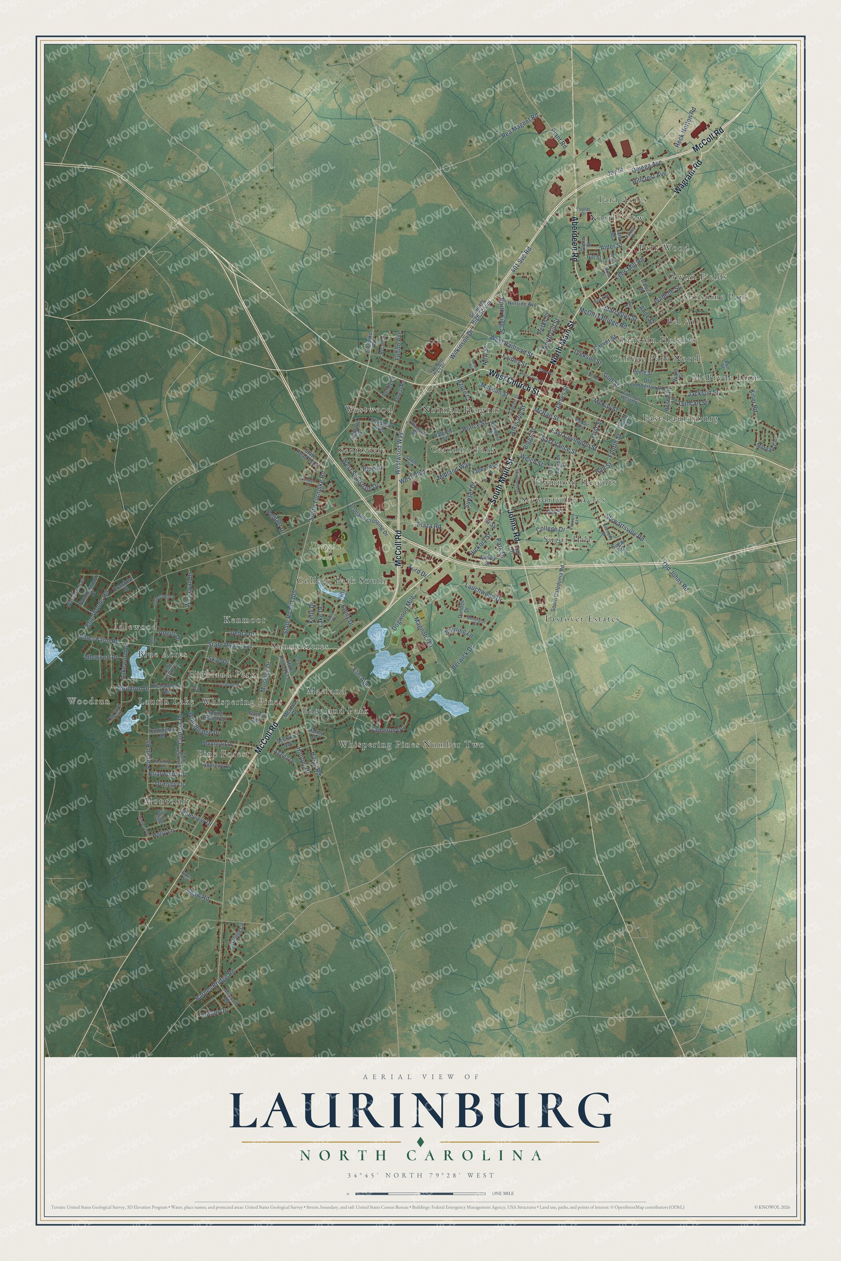
Laurinburg, North Carolina Map Art
Building by building, with labeled streets and shaded relief.
12" x 18" Archival Matte Print
A Map of Home. A Work of Art.
Explore Laurinburg, North Carolina from a whole new perspective. Created using aerial imagery and detailed geographic data, this map captures Laurinburg building by building, with labeled streets, familiar landmarks, and shaded topographical relief that highlights the natural contours of the landscape.
Combining modern data with the timeless character of a vintage atlas, this map is just as interesting up close as it is beautiful on the wall. Whether you grew up in Laurinburg, spent memorable years there, or call it home today, this unique map is a great way to celebrate a place that means something to you. Zoom in on the preview to look for your street, and then order a print to put your memories on the wall.
Three ways to hang it

Unframed archival matte, a black wood frame or a white wood frame.
Up close
Geography Worth Displaying
This map was created using accurate cartographic data and authoritative geographic sources, including the U.S. Geological Survey and the Census Bureau. The map brings together terrain, waterways, roads, and building detail. The majority of the streets are labeled, houses are accurately depicted, and the topography is derived from government sources. Combining local data with carefully composed color and shading leads to this beautifully detailed Laurinburg artwork for your wall.
Rather than simply showing street outlines, we’ve included as many of the street names as we could reasonably fit on the map while keeping their names legible. Zoom in on the high resolution preview to see exactly what’s on the map. We truly set out to create a statement piece for anyone who loves Laurinburg. So whether it’s for you, or a gift for someone you love, we hope this map of Laurinburg brings back fond memories.
Read the story behind this map of Laurinburg, North Carolina from 2026.

Find your street
Names on the Laurinburg map
Every name below is printed on this map. Look for your street, your school, the park where you played, or the pond down the road.
Places and landmarks33
- Woodrun
- Dragon Park
- Bel Air
- Blue Acres
- Carolina Park
- College Park North
- College Park South
- East Laurinburg
- Eastover Estates
- Edgeland Park
- Glynn Fields
- Hammon Heights
Show all 33 places
- Highland Park
- Idlewood
- Kenmoor
- Laurin Lake
- Lincoln Heights
- Macland
- McBryde Farm
- Montclair
- Norman Heights
- North View
- Park Wood
- Pine Forest
- Scottsdale
- Stewartville Acres
- Sugar Hill
- Sunny Acres
- Sunshine Park
- Tara Acres
- Westwood
- Whispering Pines
- Whispering Pines Number Two
Streets and roads180
- McColl Road
- South Main Street
- North Main Street
- Wagram Road
- West Church Street
- Aberdeen Road
- Johns Road
- Wilkinson Drive
- North King Street
- 401 Svc Road
- South Turnpike Road
- West Scotsdale Drive
- Stewartsville Road
- Emily Drive
- West Railroad Street
- Old Johns Road
- Alder Street
- Woodrun Drive
- State Road 1105
- Blues Farm Road
- State Road 1117
- Purcell Road
- West Boulevard
- Biggs Street
- Atkinson Street
- Lauchwood Drive
- Hasty Road
- Cypress Drive
- McGirts Bridge Road
- North Gill Street
Show all 180 streets
- Lake Drive
- Dogwood Mile
- East Vance Street
- Blue Woods Road
- Elm Avenue
- Lees Mill Road
- East Covington Street
- Wesleyan Drive
- Sunset Drive
- Berwick Drive
- Barnes Bridge Road
- McKay Street
- Jackson Street
- Pineview Drive
- Magnolia Drive
- Joy Street
- James Street
- First Street
- Cameron Drive
- Midland Way
- Fairley Street
- Hall Street
- Azure Court
- Westwood Way
- Kiser Road
- Plaza Road
- Holly Lane
- McLean Street
- Dickson Street
- Moseley Drive
- Duncan Street
- Prince Street
- Gulf Street
- Debra Drive
- Lakewood Drive
- Plant Road
- Carver Street
- Hickory Street
- Marcellus Street
- Fourth Street
- Pitt Street
- Shaw Road
- Heck Norton Road
- Isabelle Street
- Anne Street
- Rea Magnet Road
- College Drive
- Hillcrest Avenue
- Hooper Drive
- Fulton Avenue
- McRae Street
- Woodbridge Drive
- Welch Street
- Idlewood Drive
- Cotton Drive
- Omega Avenue
- Ormsby Drive
- Briarwood Drive
- Park Drive
- Angus Drive
- New Street
- Sterling Lane
- Blue Drive
- Ford Drive
- Pelham Drive
- Perks Street
- Kelly Drive
- Skye Drive
- South Caledonia Road
- State Road 1615
- Old Lumberton Road
- State Road 1116
- Scotland Crossing Drive
- Highland Drive
- Hillside Avenue
- Sugar Road
- Tara Drive
- Montclair Drive
- Raleigh Street
- Shepherd Avenue
- Morgan Circle
- Scotland High School
- Forest Road
- Deerfield Circle
- Crawford Street
- Daluca Street
- Harrison Street
- Spring Branch Drive
- Olde Farm Circle
- Yadkin Avenue
- Haney Drive
- Azalea Drive
- Randomwood Drive
- Dundee Drive
- McLeod Road
- Turnpike Road
- Peele Street
- Scottish Avenue
- Richardson Road
- Huntington Drive
- Andrews Drive
- Charlotte Street
- Willow Street
- Rosemary Lane
- Bundy Lane
- McLeod Drive
- Glenn Street
- Gaston Avenue
- Ward Street
- Hill Street
- Ivy Street
- Carl Drive
- Scotland High Drive
- State Road 1204
- Anita Drive
- Everett Street
- McNair Avenue
- Oak Croft Trail
- Elizabeth Drive
- Muse Street
- Ashley Drive
- Pinewood Trail
- Patsy Lane
- Common Wealth Street
- Montrose Drive
- Britt Street
- Ingleside Drive
- Salem Street
- Hood Street
- Richmond Street
- Sweet Gum Circle
- Pecan Lane
- Kennedy Street
- Flowers Street
- Poplar Drive
- Revel Street
- Appin Road
- Stratford Drive
- West Cronly Street
- McKinnon Drive
- Zion Street
- Neal Lane
- Center Street
- Mills Street
- Coble Drive
- Mistletoe Drive
- Lanoca Avenue
- Kenwyn Drive
- Beech Street
- Roper Street
Names are listed as they appear on the printed map. Zoom into the product photos to find them.
About Laurinburg, North Carolina
Laurinburg is a city of 14,978 people and the county seat of Scotland County, near the South Carolina line. Settlers came to the site around 1785, and the place took its name from the McLaurin family, early Scottish settlers. It was first spelled Laurinburgh and said like "Laurinboro," the way Scots say Edinburgh, until the "h" was dropped. In 1840 the place held only a saloon, a store and a handful of shacks.
The Wilmington, Charlotte and Rutherford Railroad laid its line through town in the 1850s, and the first train pulled in during 1861. In 1865 the railroad moved its shops here, hoping they would be safer from the Union Army. Union troops reached Laurinburg that March anyway and burned the depot and the temporary shops. The shops were rebuilt, and the town was incorporated in 1877. When the shops left in 1894 and cotton prices fell, land lost value and hard times followed.
- A new county in 1899Richmond County had a Black majority that often backed Republicans. From May to November 1898, white Democrats and the armed Red Shirts staged riots in Laurinburg and around the county to scare Black and white Fusion voters. By Election Day, Wilmington's Morning Star reported, over five hundred Black voters had left the rolls, most in Laurinburg. After the Democrats swept the vote, the area became Scotland County in 1899, with Laurinburg its seat in 1900.
- Laurinburg Institute, 1904As Black citizens lost their voice in public affairs and their share of public money, they founded the Laurinburg Normal Industrial Institute in 1904. It was later known as Laurinburg Academy. Charlie Scott, an NBA All-Star and 1968 Olympic gold medalist, was valedictorian there.
- A sister city in ScotlandThe town still honors the Scottish roots of the McLaurins who gave it their name. Through Sister Cities International, Laurinburg is paired with Oban, a town in Argyll and Bute, Scotland.
Keep exploring North Carolina
Laurinburg is one of 952 North Carolina towns we've mapped. Every dot on the map is a print of its own.
The search covers every state, North Carolina first.
Near Laurinburg
Order 2 or more town maps and save 10%. Shown in the size and finish you picked above, so they hang as a set.
- East Laurinburg 12" x 18" / Archival Matte Print $39.99
- Laurel Hill 12" x 18" / Archival Matte Print $39.99
- Scotch Meadows 12" x 18" / Archival Matte Print $39.99


More maps nearby: Maxton, Gibson, Old Hundred, Spring Hill and Wagram.
The art of mapping a place
How This Map Was Made
Real places. Remarkable detail. Discover the layers that turn geographic data into a map of home.

The view from above
Aerial imagery reveals the character of the land: woodland, open fields, and the patterns of a place.

The shape of the land
Elevation data brings hills, valleys, and subtle changes in the landscape into view.

The details of home
Roads, waterways, and building footprints come together to make the map feel unmistakably local.

Geography becomes art
Considered color, shading, and typography bring the layers together in a map made for your wall.


Process illustrated with Mendon, Massachusetts. Aerial imagery: USDA NAIP. Terrain: USGS 3D Elevation Program. Map details and finished artwork: KNOWOL.
The Details
About This Print
Choose an archival matte print, or a black or white Ayous wood frame. The archival matte print is unframed.
Select your size and finish above to see the matching product image and price.
Materials & Craftsmanship
A contemporary map with the character of a classic atlas, printed on archival matte paper. Optional frames are made from Ayous wood.
Your printed map does not include the watermark shown in the full-map preview.
Shipping & Delivery
Free shipping within the United States. Every print is made to order in the USA.
Buying a gift? Add a note in your cart and we'll include it. We never put prices in the package.
Prints ship within 2 to 3 business days. Allow 7 to 10 days total from ordering for delivery. Timing may vary during holidays or periods of high order volume.
Read our shipping policy.
Returns and damaged prints
Each print is made to order. Change-of-mind refunds are not available after production.
If your print arrives damaged, misprinted or incorrect, contact support@knowol.com within 30 days of receiving it. Include your order number, photos and a description of the issue.
Read our full refund and replacement policy. For questions about your order, email support@knowol.com.