


Search for another town


Free U.S. delivery 7 to 10 days after you order
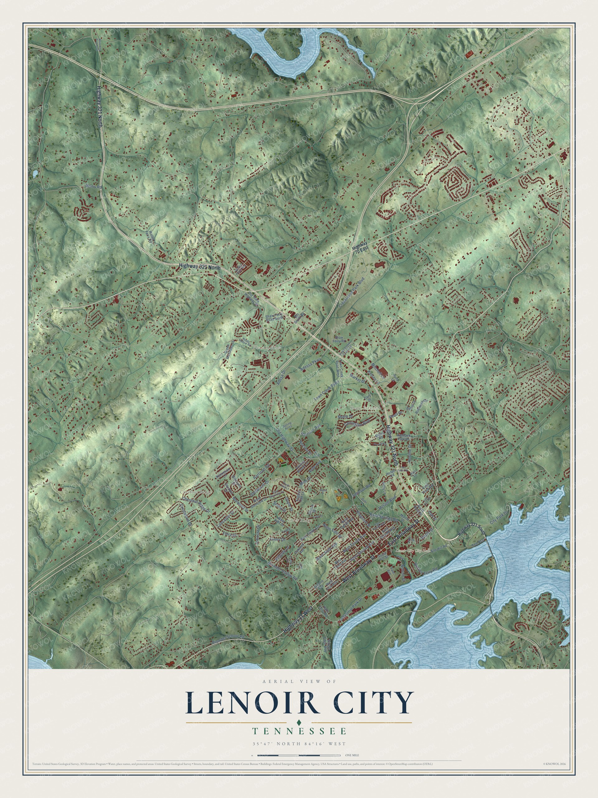
Lenoir City, Tennessee Map Art
Building by building, with labeled streets and shaded relief.
12" x 18" Archival Matte Print
A Map of Home. A Work of Art.
Explore Lenoir City, Tennessee from a whole new perspective. Created using aerial imagery and detailed geographic data, this map captures Lenoir City building by building, with labeled streets, familiar landmarks, and shaded topographical relief that highlights the natural contours of the landscape.
Combining modern data with the timeless character of a vintage atlas, this map is just as interesting up close as it is beautiful on the wall. Whether you grew up in Lenoir City, spent memorable years there, or call it home today, this unique map is a great way to celebrate a place that means something to you. Zoom in on the preview to look for your street, and then order a print to put your memories on the wall.
Three ways to hang it

Unframed archival matte, a black wood frame or a white wood frame.
Up close
Geography Worth Displaying
This map was created using accurate cartographic data and authoritative geographic sources, including the U.S. Geological Survey and the Census Bureau. The map brings together terrain, waterways, roads, and building detail. The majority of the streets are labeled, houses are accurately depicted, and the topography is derived from government sources. Combining local data with carefully composed color and shading leads to this beautifully detailed Lenoir City artwork for your wall.
Rather than simply showing street outlines, we’ve included as many of the street names as we could reasonably fit on the map while keeping their names legible. Zoom in on the high resolution preview to see exactly what’s on the map. We truly set out to create a statement piece for anyone who loves Lenoir City. So whether it’s for you, or a gift for someone you love, we hope this map of Lenoir City brings back fond memories.
Read the story behind this map of Lenoir City, Tennessee from 2026.

Find your street
Names on the Lenoir City map
Every name below is printed on this map. Look for your street, your school, the park where you played, or the pond down the road.
Places and landmarks5
- Lenoir City City Hall
- Sharp Estates
- Chestnut Ridge
- Silver Ridge
- Pleasant View
Streets and roads111
- Highway 321 North
- East Broadway Street
- West Broadway Street
- Highway 11 West
- Harrison Road
- Town Creek Parkway
- Industrial Park Drive
- Harrison Avenue
- Maple Street
- Old Highway 95
- Kingston Street
- City Park Drive
- Creekwood Park Boulevard
- Simpson Road
- Browder Hollow Road
- Adessa Parkway
- West Second Avenue
- Adesa Drive
- Rock Springs Road
- Glenbrook Drive
- West Sixth Avenue
- North East Street
- Sharp Drive
- Finley Drive
- Flora Drive
- Carrington Boulevard
- West Fourth Avenue
- Johnson Drive
- McGee Boulevard
- Browder School Road
Show all 111 streets
- Crestwood Drive
- Nelson Street
- Chestnut Ridge Drive
- Norwood Street
- Bussell Ferry Road
- Kelsey Lane
- Lancaster Drive
- Henline Drive
- Manis Road
- Doyle Street
- Hillside Lane
- Ashe Avenue
- Oak Street
- Tva Acc
- Pearl Drive
- Mitchell Lane
- Market Drive
- Reeves Street
- Mills Drive
- Selma Street
- Highway 321 South
- Highway 70 East
- West First Avenue
- Yale Avenue
- West Tenth Avenue
- Church Drive
- West Hills Drive
- East Second Avenue
- Town Creek Road West
- West Third Avenue
- East Third Avenue
- Shaw Ferry Road North
- Elm Hill Road
- Bethel Drive
- Oakland Avenue
- Biscayne Drive
- Shaw Ferry Road
- West Glenview Drive
- Green Meadows Lane
- South Hill Street
- Old State Highway 95
- Kelly Lane
- Paisley Reece Lane
- Waller Ferry Road
- Martin Drive
- West Eighth Avenue
- Highland Park Drive
- Robinson Circle
- Waters Edge Way
- Pike Street
- Cory Drive
- Second Avenue
- Bill Smith Road
- Halls Ferry Road
- Kennesaw Lane
- North Rose Street
- Olympic Drive
- English Oak Lane
- Myers Road
- Tracy Lane
- Heape Road
- Rudy Lane
- Hair Lane
- East Fourth Avenue
- Happy Hollow Road
- East Glenview Drive
- Rolling Acres
- Town Creek Road East
- Coffey Circle
- Golden Place Way
- Thuja Tree Lane
- East First Avenue
- Twin Lakes Road
- Wilson Street
- Pinewood Drive
- Crisp Road
- Shady Lane
- White Wing Road North
- Vincil Street
- Coley Lane
- Rogers Drive
Names are listed as they appear on the printed map. Zoom into the product photos to find them.
About Lenoir City, Tennessee
Lenoir City is a city of 10,117 people in Loudon County, on the Tennessee River southwest of Knoxville. North Carolina paid General William Lenoir for his Revolutionary War service with a 5,000-acre tract that took in this ground. Earlier settlers David Campbell and Alexander Outlaw sued over parts of it, but Lenoir won in 1809 and gave the land to his eldest son. William Ballard Lenoir moved there in 1810 and built a large plantation worked by enslaved African Americans.
Charles McClung McGhee, a Knoxville railroad magnate, joined with his associate Edward J. Sanford in 1889 to form the Lenoir City Company, which would build a planned town on the old plantation. The company was chartered in April 1890, raised $800,000 in stock, and paid $300 an acre for the 2,700-acre estate. A recession soon froze money markets, and by 1892 only 144 of 3,448 lots had sold. McGhee and Sanford kept going, though, and the town survived and was incorporated in 1907.
- An early Southern cotton millIn the early 1830s William Ballard Lenoir built one of the South's first cotton mills on Town Creek, beside his sawmill and flour mill. The railroad came in 1855, and Lenoir Station grew up around its depot. The Lenoir Cotton Mill Warehouse joined the National Register in 2006.
- A cotton mill spared in 1863The Lenoirs sided with the Confederacy, and on June 20, 1863, Union General William P. Sanders burned the depot along with the family's sawmill and flour mill. He left the cotton mill standing, because the region had few mills to make cloth for the army and because he and the Lenoirs were fellow Masons.
- A town planned in quartersThe company laid out a grid in four quarters west of Town Creek and north of the tracks: well-off families in the northwest, wage workers in the northeast, blast furnaces and steel works in the southwest, and furniture, woodworking and canning plants in the southeast. Following health and temperance ideas, planners saved lots for parks and a garden between the tracks and river. The Lenoir City Company joined the National Register in 1982.
- Lenoir Car WorksTo bring in jobs, McGhee persuaded a rail car maker to open a plant in town, and a knitting mill followed soon after. The Bass Foundry and Machine Shop came to build cars for the Southern Railroad Company, doing business as Lenoir Car Works. In 1910 the car works and the knitting mill each still kept several hundred people at work.
- The tornado of 1993On February 21, 1993, an F-3 tornado took shape a short way west of town, in eastern Roane County, and headed straight for Lenoir City. It wrecked parts of downtown and the neighborhood around A Street and 5th Avenue, and it badly damaged the high school and middle school campus, which was later rebuilt as River Oaks Place. One person in Lenoir City was killed and 55 were hurt.
Keep exploring Tennessee
Lenoir City is one of 640 Tennessee towns we've mapped. Every dot on the map is a print of its own.
The search covers every state, Tennessee first.
Near Lenoir City
Order 2 or more town maps and save 10%. Shown in the size and finish you picked above, so they hang as a set.
- Highland Park 12" x 18" / Archival Matte Print $39.99
- Eaton 12" x 18" / Archival Matte Print $39.99
- Loudon 12" x 18" / Archival Matte Print $39.99


More maps nearby: Farragut, Tellico Village, Friendsville, Oak Ridge and Philadelphia.
The art of mapping a place
How This Map Was Made
Real places. Remarkable detail. Discover the layers that turn geographic data into a map of home.

The view from above
Aerial imagery reveals the character of the land: woodland, open fields, and the patterns of a place.

The shape of the land
Elevation data brings hills, valleys, and subtle changes in the landscape into view.

The details of home
Roads, waterways, and building footprints come together to make the map feel unmistakably local.

Geography becomes art
Considered color, shading, and typography bring the layers together in a map made for your wall.


Process illustrated with Mendon, Massachusetts. Aerial imagery: USDA NAIP. Terrain: USGS 3D Elevation Program. Map details and finished artwork: KNOWOL.
The Details
About This Print
Choose an archival matte print, or a black or white Ayous wood frame. The archival matte print is unframed.
Select your size and finish above to see the matching product image and price.
Materials & Craftsmanship
A contemporary map with the character of a classic atlas, printed on archival matte paper. Optional frames are made from Ayous wood.
Your printed map does not include the watermark shown in the full-map preview.
Shipping & Delivery
Free shipping within the United States. Every print is made to order in the USA.
Buying a gift? Add a note in your cart and we'll include it. We never put prices in the package.
Prints ship within 2 to 3 business days. Allow 7 to 10 days total from ordering for delivery. Timing may vary during holidays or periods of high order volume.
Read our shipping policy.
Returns and damaged prints
Each print is made to order. Change-of-mind refunds are not available after production.
If your print arrives damaged, misprinted or incorrect, contact support@knowol.com within 30 days of receiving it. Include your order number, photos and a description of the issue.
Read our full refund and replacement policy. For questions about your order, email support@knowol.com.