


Search for another town


Free U.S. delivery 7 to 10 days after you order
Louisville, Kentucky Map Art
Building by building, with labeled streets and shaded relief.
12" x 18" Archival Matte Print
A Map of Home. A Work of Art.
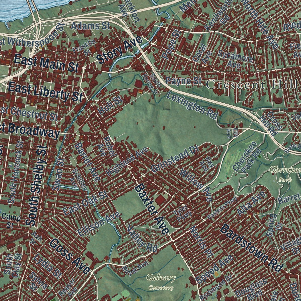
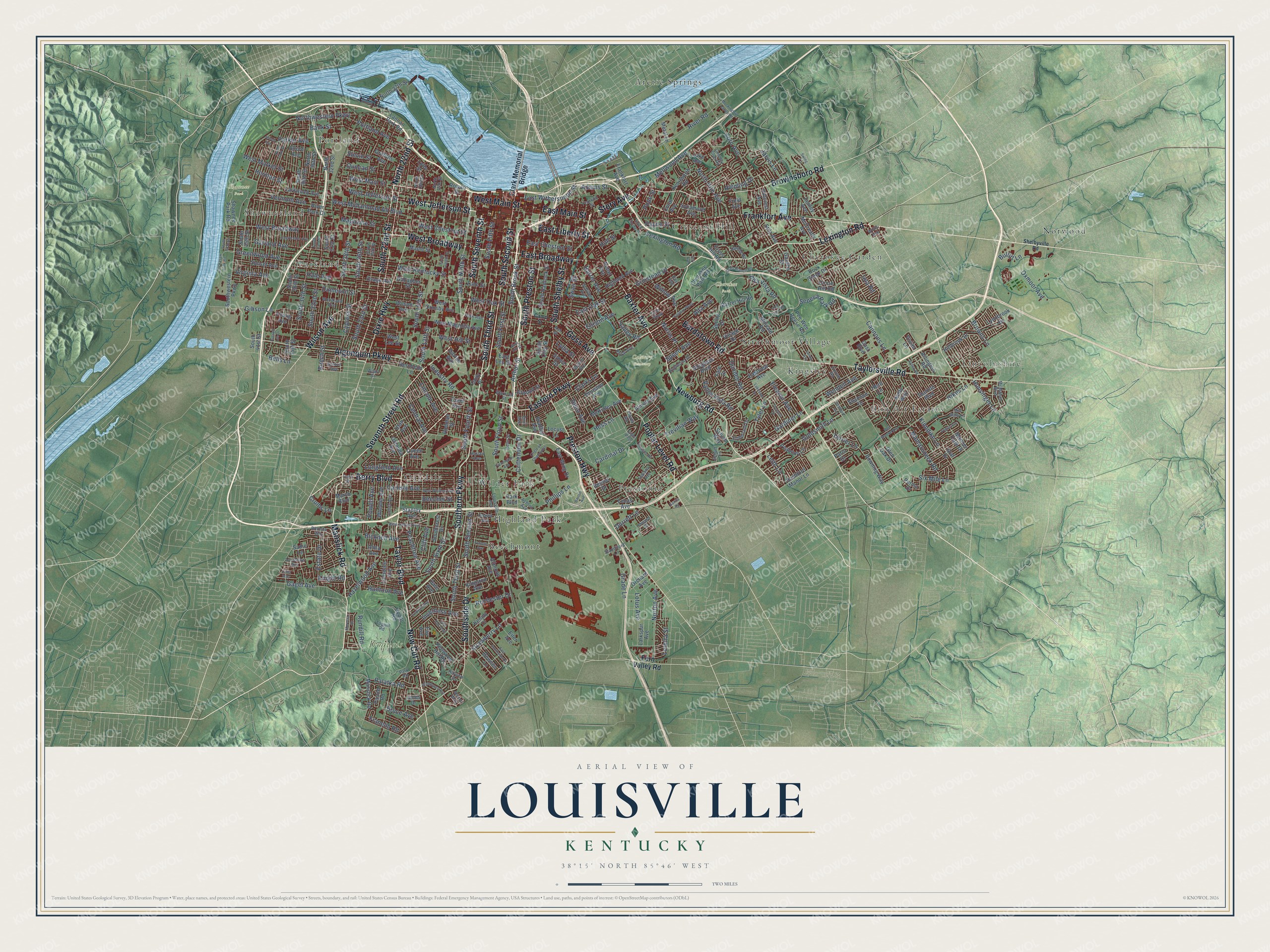
Explore Louisville, Kentucky from a whole new perspective. Created using aerial imagery and detailed geographic data, this map captures Louisville building by building, with labeled streets, familiar landmarks, and shaded topographical relief that highlights the natural contours of the landscape.
Combining modern data with the timeless character of a vintage atlas, this map is just as interesting up close as it is beautiful on the wall. Whether you grew up in Louisville, spent memorable years there, or call it home today, this unique map is a great way to celebrate a place that means something to you. Zoom in on the preview to look for your street, and then order a print to put your memories on the wall.
Three ways to hang it

Unframed archival matte, a black wood frame or a white wood frame.
Up close
Geography Worth Displaying
This map was created using accurate cartographic data and authoritative geographic sources, including the U.S. Geological Survey and the Census Bureau. The map brings together terrain, waterways, roads, and building detail. The majority of the streets are labeled, houses are accurately depicted, and the topography is derived from government sources. Combining local data with carefully composed color and shading leads to this beautifully detailed Louisville artwork for your wall.
Rather than simply showing street outlines, we’ve included as many of the street names as we could reasonably fit on the map while keeping their names legible. Zoom in on the high resolution preview to see exactly what’s on the map. We truly set out to create a statement piece for anyone who loves Louisville. So whether it’s for you, or a gift for someone you love, we hope this map of Louisville brings back fond memories.
Read the story behind this map of Louisville, Kentucky from 2026.

Find your street
Names on the Louisville map
Every name below is printed on this map. Look for your street, your school, the park where you played, or the pond down the road.
Places and landmarks20
- Calvary Cemetery
- Cherokee Park
- Iroquois Park
- Shawnee Park
- Arctic Springs
- Beechmont
- Bon Air Estates
- Cherokee Garden
- Crescent Hill
- Highland Park
- Kingsley
- Lincolnshire
Show all 20 places
- Norwood
- Oakdale
- Parkland
- Portland
- Prestonia
- Shawneeland
- Strathmoor Village
- Wilder Park
Streets and roads348
- South Third Street
- Frankfort Avenue
- Taylor Boulevard
- Newburg Road
- South Seventh Street
- South 22nd Street
- South Second Street
- Seventh Street Road
- Manslick Road
- Lexington Road
- Southern Parkway
- Baxter Avenue
- West Main Street
- West Jefferson Street
- New Cut Road
- East Liberty Street
- Berry Boulevard
- Story Avenue
- East Main Street
- Bardstown Road
- Algonquin Parkway
- Taylorsville Road
- Eastern Parkway
- Preston Highway
- South Preston Street
- South Shelby Street
- Brownsboro Road
- Poplar Level Road
- Southside Drive
- Dixie Highway
Show all 348 streets
- West Broadway
- Wilson Avenue
- East Broadway
- Goss Avenue
- North 22nd Street
- South Fifth Street
- River Road
- South Ninth Street
- Dumesnil Street
- Hale Avenue
- Grinstead Drive
- West Oak Street
- Virginia Avenue
- East Oak Street
- East Chestnut Street
- South Fourth Street
- South 13th Street
- Longfield Avenue
- South First Street
- West Market Street
- Crittenden Drive
- South Brook Street
- South Floyd Street
- West Kentucky Street
- West Muhammad Ali Boulevard
- South Sixth Street
- Garland Avenue
- Rundill Road
- Northwestern Parkway
- South 15th Street
- Bank Street
- West Hill Street
- West Chestnut Street
- Greenwood Avenue
- Goldsmith Lane
- South 28th Street
- South 34th Street
- Cannons Lane
- Duncan Street
- Trevilian Way
- South 32nd Street
- Hikes Lane
- Gardiner Lane
- South 23rd Street
- Zorn Avenue
- Strawberry Lane
- Magazine Street
- Payne Street
- Barret Avenue
- South 26th Street
- Central Avenue
- Portland Avenue
- Palatka Road
- Norton Avenue
- Mellwood Avenue
- Peachtree Avenue
- Lincoln Avenue
- Cliff Avenue
- Beech Street
- Cardinal Drive
- Cypress Street
- Speed Avenue
- Dundee Road
- Durrett Lane
- Delor Avenue
- Vermont Avenue
- Gagel Avenue
- Hazelwood Avenue
- Herman Street
- Oxmoor Avenue
- Alta Vista Road
- Eleanor Avenue
- Mamaroneck Road
- Seneca Park Road
- Tyler Lane
- Klondike Lane
- Powell Avenue
- Hess Lane
- Phillips Lane
- Gibson Lane
- Inverness Avenue
- Norris Place
- Jarvis Lane
- East Witherspoon Street
- Bruce Avenue
- Lotus Avenue
- North Hite Avenue
- Browns Lane
- Bicknell Avenue
- Estate Drive
- Valley Vista Road
- Clarks Lane
- Carlisle Avenue
- Industry Road
- Lydia Street
- Beecher Street
- Adams Street
- Arthur Street
- Ellison Avenue
- Grade Lane
- Swan Street
- Six Mile Lane
- Willow Avenue
- Parker Avenue
- Rochester Drive
- Terrier Lane
- Wendell Avenue
- Franelm Road
- Slevin Street
- Knight Road
- Alta Avenue
- Huntoon Avenue
- Hunsinger Lane
- Riedling Drive
- Loretta Street
- Iola Road
- Leith Lane
- Pope Street
- Crums Lane
- Bells Lane
- Bullitt Lane
- Valley Road
- Hull Street
- Clark Memorial Bridge
- Fern Valley Road
- South 38th Street
- North 36th Street
- Cherokee Park Road
- Southwestern Parkway
- South 41st Street
- Pee Wee Reese Road
- West Ormsby Avenue
- South Clay Street
- Shawnee Park Road
- Illinois Avenue
- South Hancock Street
- Belmar Drive
- South 36th Street
- River Park Drive
- West Magnolia Avenue
- South 35th Street
- Allmond Avenue
- Douglass Boulevard
- West Lee Street
- Uppill Road
- North 27th Street
- Lytle Street
- Stanton Boulevard
- Larkwood Avenue
- Maple Street
- Highland Avenue
- Utah Avenue
- Griffiths Avenue
- Wheeler Avenue
- Kingston Avenue
- Bradley Avenue
- South 45th Street
- Sylvan Way
- Bernheim Lane
- Oleanda Avenue
- Lynnbrook Drive
- Village Drive
- South 31st Street
- Larkspur Avenue
- Bashford Manor Lane
- Orchard Avenue
- Sunset Avenue
- Young Avenue
- Alford Avenue
- Hillbrook Drive
- Spring Drive
- Rubel Avenue
- Rodman Street
- Peabody Lane
- McKinley Avenue
- Park Boulevard
- Barret Hill Road
- Thruston Avenue
- Rock Creek Drive
- McCready Avenue
- Hillcrest Avenue
- Eastview Avenue
- Field Avenue
- Manner Dale Drive
- Eiler Avenue
- Locust Lane
- Metal Lane
- Rowan Street
- Osage Avenue
- Lonsdale Avenue
- Downing Way
- East Lee Street
- East Wing Drive
- Yale Drive
- Circle Hill Road
- Kelly Way
- Kenwood Hill Road
- Stilz Avenue
- Cross Hill Road
- Downes Lane
- Zane Street
- Kenilworth Road
- Garden Drive
- North 32nd Street
- Gallagher Street
- Lake Avenue
- Southcrest Drive
- Shannon Drive
- Millvale Road
- Arlington Road
- Stanley Avenue
- Creel Avenue
- Sadie Lane
- Atwood Street
- Sycamore Avenue
- Fenley Avenue
- Davies Avenue
- Vivian Lane
- Coral Avenue
- Gast Boulevard
- Kenjoy Drive
- Glen Oak Drive
- Lannan Park Road
- Lucas Avenue
- Paiute Road
- Sylvia Street
- Queen Avenue
- Alma Avenue
- Paris Drive
- Perma Drive
- Graf Drive
- Jones Drive
- Dale Avenue
- Unity Place
- Fay Avenue
- March Boulevard
- Herb Lane
- South 24th Street
- Toppill Road
- Woodland Avenue
- Howard Street
- Conn Street
- Louisville Avenue
- Richmond Drive
- Ash Street
- Lentz Avenue
- Country Club Road
- Schiller Avenue
- Mid Dale Lane
- Franklin Street
- North 18th Street
- Indiana Avenue
- Upland Road
- Park Road
- Sutherland Drive
- Reasor Avenue
- Schuff Lane
- McMahan Boulevard
- Park Avenue
- Rhonda Way
- Warnock Street
- Standiford Lane
- Ashton Avenue
- Royal Avenue
- Willis Avenue
- Lou Gene Avenue
- Allston Avenue
- Curran Road
- Ottawa Avenue
- Tyler Parkway
- Ray Avenue
- Hillview Drive
- Helm Street
- North 15th Street
- Emil Avenue
- Alvina Way
- Harlan Avenue
- Plover Road
- Wilart Drive
- Shelbyville Road
- Camp Street
- Beals Branch Road
- Jewell Avenue
- South Twelfth Street
- West Whitney Avenue
- Circle of Champions
- West Ashland Avenue
- Doerhoefer Avenue
- Lakeside Drive
- Mockingbird Valley Road
- Chickasaw Park Road
- Lone Oak Trail
- Iroquois Avenue
- Fincastle Road
- Tremont Drive
- Russell Lee Drive
- East Hill Street
- Woodmore Avenue
- East Southside Court
- North 43rd Street
- Stratford Avenue
- Farmington Avenue
- Vogue Avenue
- Eagle Pass
- Red Fox Road
- Dell Brooke Avenue
- South 47th Street
- South 33rd Street
- Landor Avenue
- South Spring Street
- Arden Road
- Morocco Drive
- Barton Avenue
- Linda Way
- Francis Avenue
- Sanita Road
- Swing Lane
- Etly Avenue
Names are listed as they appear on the printed map. Zoom into the product photos to find them.
About Louisville, Kentucky
Louisville is the seat of Jefferson County, beside the Falls of the Ohio River. Col. George Rogers Clark made the first European settlement nearby in 1778, on Corn Island. The falls were the one big barrier for boats between the upper Ohio and the Gulf of Mexico, so cargo had to be unloaded and carried around them, and the town grew up around that work.
In 1780 the Virginia General Assembly approved the town's charter and named it for France's King Louis XVI, whose troops were helping the Americans in the Revolutionary War. Early settlers lived inside forts for protection from raids, but by the late 1780s they had moved out. The river trade kept the town growing, and by 1828 it had 7,000 people and became an incorporated city.
- First Derby in 1875On May 17, 1875, ten thousand people watched Aristides win the first Kentucky Derby. The track belonged to the Louisville Jockey Club and was later renamed Churchill Downs. Meriwether Lewis Clark Jr., grandson of William Clark and grandnephew of the city's founder, guided the race in its early years.
- Buchanan v. Warley, 1917In 1914 Louisville passed a zoning code that kept Black and white residents on separate blocks. William Warley, head of the local NAACP chapter, offered to buy a lot on a white block from agent Charles Buchanan, then held back payment because the law barred him from living there. Buchanan sued, and in 1917 the U.S. Supreme Court struck the ordinance down under the Fourteenth Amendment.
- The Great Flood of 1937After 19.17 inches of rain that January, the Ohio crested on January 27 at a record 57.15 feet, nearly 30 feet over flood stage. Water covered 60 to 70 percent of the city, the power was out for four days, and 90 people died. Afterward new homes went up on the high ground in the east, and flood walls now guard the city.
- Camp Zachary TaylorLouisville was picked in 1917, soon after the U.S. entered World War I, as the site of one of the country's largest training camps, home of the 84th Infantry Division. It trained over 150,000 men, F. Scott Fitzgerald among them, before closing in 1921. Much of today's Camp Taylor neighborhood grew from its buildings and streets.
Keep exploring Kentucky
Louisville is one of 659 Kentucky towns we've mapped. Every dot on the map is a print of its own.
The search covers every state, Kentucky first.
Near Louisville
Order 2 or more town maps and save 10%. Shown in the size and finish you picked above, so they hang as a set.
- Parkway Village 12" x 18" / Archival Matte Print $39.99
- Audubon Park 12" x 18" / Archival Matte Print $39.99
- Strathmoor Manor 12" x 18" / Archival Matte Print $39.99


More maps nearby: Strathmoor Village, Seneca Gardens, Lynnview, Kingsley and Shively.
The art of mapping a place
How This Map Was Made
Real places. Remarkable detail. Discover the layers that turn geographic data into a map of home.

The view from above
Aerial imagery reveals the character of the land: woodland, open fields, and the patterns of a place.

The shape of the land
Elevation data brings hills, valleys, and subtle changes in the landscape into view.

The details of home
Roads, waterways, and building footprints come together to make the map feel unmistakably local.

Geography becomes art
Considered color, shading, and typography bring the layers together in a map made for your wall.


Process illustrated with Mendon, Massachusetts. Aerial imagery: USDA NAIP. Terrain: USGS 3D Elevation Program. Map details and finished artwork: KNOWOL.
The Details
About This Print
Choose an archival matte print, or a black or white Ayous wood frame. The archival matte print is unframed.
Select your size and finish above to see the matching product image and price.
Materials & Craftsmanship
A contemporary map with the character of a classic atlas, printed on archival matte paper. Optional frames are made from Ayous wood.
Your printed map does not include the watermark shown in the full-map preview.
Shipping & Delivery
Free shipping within the United States. Every print is made to order in the USA.
Buying a gift? Add a note in your cart and we'll include it. We never put prices in the package.
Prints ship within 2 to 3 business days. Allow 7 to 10 days total from ordering for delivery. Timing may vary during holidays or periods of high order volume.
Read our shipping policy.
Returns and damaged prints
Each print is made to order. Change-of-mind refunds are not available after production.
If your print arrives damaged, misprinted or incorrect, contact support@knowol.com within 30 days of receiving it. Include your order number, photos and a description of the issue.
Read our full refund and replacement policy. For questions about your order, email support@knowol.com.