


Search for another town


Free U.S. delivery 7 to 10 days after you order
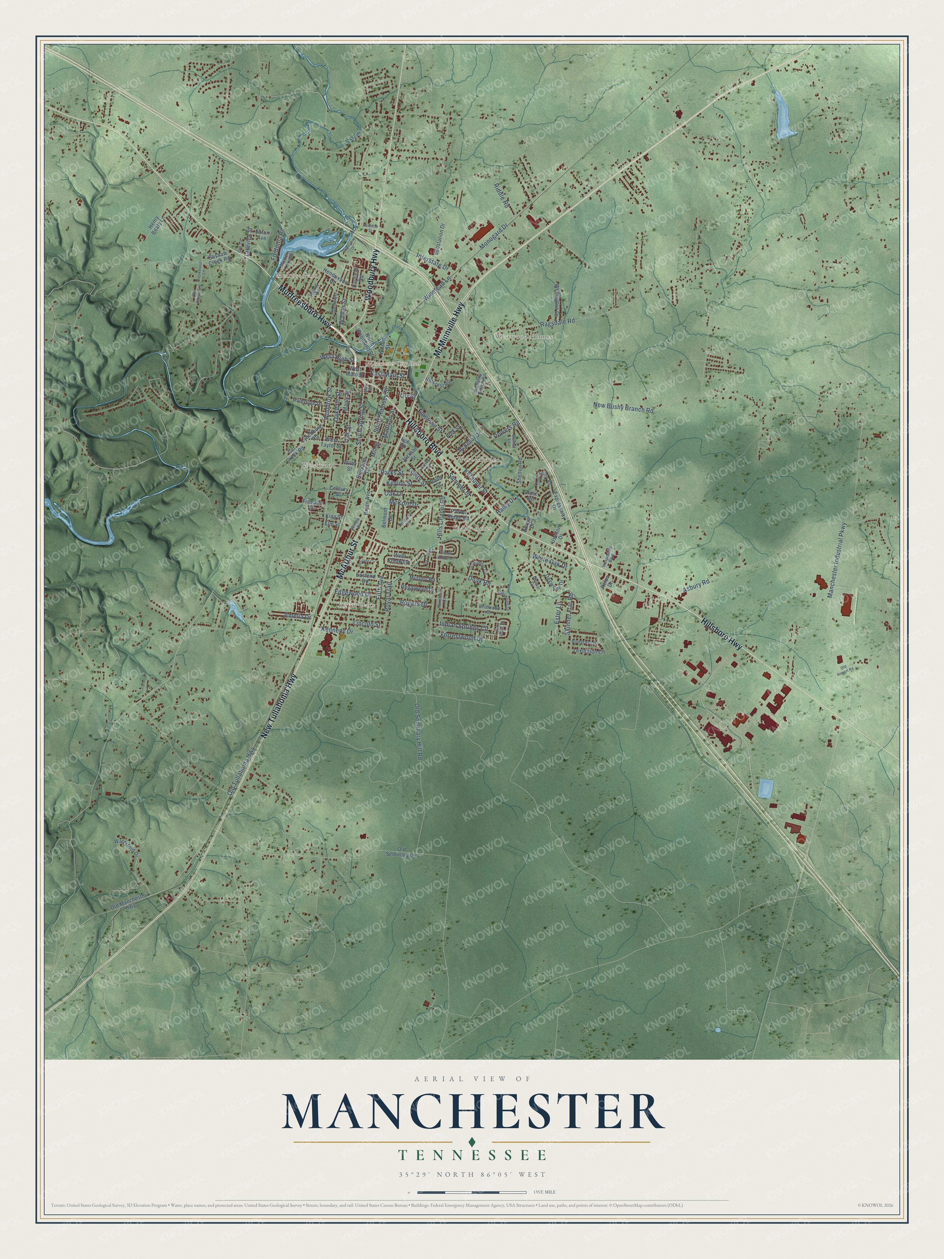
Manchester, Tennessee Map Art
Building by building, with labeled streets and shaded relief.
12" x 18" Archival Matte Print
A Map of Home. A Work of Art.
Explore Manchester, Tennessee from a whole new perspective. Created using aerial imagery and detailed geographic data, this map captures Manchester building by building, with labeled streets, familiar landmarks, and shaded topographical relief that highlights the natural contours of the landscape.
Combining modern data with the timeless character of a vintage atlas, this map is just as interesting up close as it is beautiful on the wall. Whether you grew up in Manchester, spent memorable years there, or call it home today, this unique map is a great way to celebrate a place that means something to you. Zoom in on the preview to look for your street, and then order a print to put your memories on the wall.
Three ways to hang it

Unframed archival matte, a black wood frame or a white wood frame.
Up close
Geography Worth Displaying
This map was created using accurate cartographic data and authoritative geographic sources, including the U.S. Geological Survey and the Census Bureau. The map brings together terrain, waterways, roads, and building detail. The majority of the streets are labeled, houses are accurately depicted, and the topography is derived from government sources. Combining local data with carefully composed color and shading leads to this beautifully detailed Manchester artwork for your wall.
Rather than simply showing street outlines, we’ve included as many of the street names as we could reasonably fit on the map while keeping their names legible. Zoom in on the high resolution preview to see exactly what’s on the map. We truly set out to create a statement piece for anyone who loves Manchester. So whether it’s for you, or a gift for someone you love, we hope this map of Manchester brings back fond memories.
Read the story behind this map of Manchester, Tennessee from 2026.

Find your street
Names on the Manchester map
Every name below is printed on this map. Look for your street, your school, the park where you played, or the pond down the road.
Places and landmarks7
- Manchester City Hall
- Melrose Park
- Royal Oaks
- Westwood Homes
- Westwood
- West Meade
- Shady Acres
Streets and roads126
- Murfreesboro Highway
- Hillsboro Boulevard
- New Tullahoma Highway
- McMinnville Highway
- McArthur Street
- Woodbury Highway
- Hillsboro Highway
- South Spring Street
- Old Tullahoma Highway
- East Main Street
- Hills Chapel Road
- Ragsdale Road
- Asbury Road
- New Bushy Branch Road
- Oakdale Street
- Old Seminary Hill Road
- Manchester Industrial Parkway
- Indian Springs Circle
- Doak Road
- Interstate Drive
- Royal Trail
- Madison Street
- Oak Drive
- Skinner Flat Road
- Kennedy Drive
- Summer Street
- Monogard Drive
- Oak Street
- West High Street
- Riddle Road
Show all 126 streets
- Winstead Lane
- Lincoln Street
- Woodrow Street
- Fifth Avenue
- Forrestwood Drive
- Kefauver Street
- South Ramsey Street
- Lowry Street
- Powers Road
- Parks Street
- Ester Lane
- Emerson Street
- Walker Street
- Fredonia Road
- Edgewood Drive
- McCord Drive
- Rogers Drive
- Keylon Street
- Amelia Drive
- White Oak Drive
- Haley Drive
- Orr Street
- Lynchburg Road
- Cat Creek Road
- Expressway Drive
- Hendrixson Drive
- Lexington Circle
- West Doak Road
- Waterford Drive
- Eastend Road
- Shelton Road
- Jackson Street
- Hillcrest Road
- North Woodland Street
- Old Manchester Highway
- Hayfield Square
- McKellar Drive
- Rye Street
- Substation Drive
- West Taylor Street
- Dogwood Drive
- Old Seminary Road
- Mill Street
- Wellington Drive
- Regalwood Drive
- Riverside Drive
- Henry Beaty Lane
- Bashaw Creek Road
- Polk Street
- Belmont Drive
- Maple Street
- Highland Drive
- Lakeview Street
- West Main Street
- Parker Ridge Road
- Bryan Avenue
- Wilson Street
- Murphy Road
- Wiley Street
- Uselton Drive
- King Street
- Freedom Drive
- Eaton Avenue
- Century Street
- Burger Drive
- Relco Drive
- Post Road
- Elm Street
- Bond Street
- Old Bushy Branch Road
- Mortons Lake Road
- John Mark Court
- Hospitality Boulevard
- Oak Hollow Road
- Greenbriar Circle
- Hillcrest Drive
- Belmar Circle
- Rigney Drive
- Bluegrass Drive
- Sherwood Drive
- Old Stone Circle
- Willow Drive
- Briarwood Drive
- Walnut Lane
- Windsor Court
- Ibis Lane
- Evins Street
- May Street
- Heritage Circle
- Lakeview Drive
- Glenburg Drive
- Brook Hollow Circle
- Fox Creek Court
- Creekwood Lane
- Paradise Street
- Old Airport Road
Names are listed as they appear on the printed map. Zoom into the product photos to find them.
About Manchester, Tennessee
Manchester is a city of 12,212 people and the county seat of Coffee County, Tennessee. When the county was formed in 1836, a small village called Mitchellsville already stood near the chosen site. The new seat was laid out on two hundred acres owned by James Evans and Andrew Haynes. It was renamed for Manchester, England, the great mill city. Its founders hoped the water power of the Little Duck and Big Duck rivers would make it an industrial city too.
Later, railroad officials founded Tullahoma as the midpoint of their line. They built a spur from there through Manchester to McMinnville, and in time it reached coal mines and timberland in White County. The Works Progress Administration built Manchester a post office in the Colonial Revival style. During World War II era maneuvers in Coffee County, the Second Army set up its headquarters at the Manchester high school.
- Bonnaroo since 2002Every year since 2002, Manchester has hosted the Bonnaroo Music and Arts Festival at Great Stage Park, a 650-acre outdoor event space. It is one of North America's 10 biggest outdoor festivals. For four days the city grows to nearly 100,000 people, who come from all over the country to camp and hear music. A temporary Exit "112" once ran straight off the shoulder of Interstate 24 into the festival grounds.
- Waterfalls at Old Stone FortThe Little Duck River starts where Hunt Creek and Huckleberry Creek meet. It runs through the city and meets the Duck River a little west of town. Before they join, both rivers spill over waterfalls inside Old Stone Fort State Archaeological Park, right next to the western edge of Manchester.
- A post office since 1817A post office called Manchester has been open since 1817. As the seat of Coffee County, the town is home to the Coffee County Courthouse, which joined the National Register in 1974.
Keep exploring Tennessee
Manchester is one of 640 Tennessee towns we've mapped. Every dot on the map is a print of its own.
The search covers every state, Tennessee first.
Near Manchester
Order 2 or more town maps and save 10%. Shown in the size and finish you picked above, so they hang as a set.
- New Union 12" x 18" / Archival Matte Print $39.99
- Hillsboro 12" x 18" / Archival Matte Print $39.99
- Tullahoma 12" x 18" / Archival Matte Print $39.99


More maps nearby: Normandy, Viola, Lakewood Park, Morrison and Pelham.
The art of mapping a place
How This Map Was Made
Real places. Remarkable detail. Discover the layers that turn geographic data into a map of home.

The view from above
Aerial imagery reveals the character of the land: woodland, open fields, and the patterns of a place.

The shape of the land
Elevation data brings hills, valleys, and subtle changes in the landscape into view.

The details of home
Roads, waterways, and building footprints come together to make the map feel unmistakably local.

Geography becomes art
Considered color, shading, and typography bring the layers together in a map made for your wall.


Process illustrated with Mendon, Massachusetts. Aerial imagery: USDA NAIP. Terrain: USGS 3D Elevation Program. Map details and finished artwork: KNOWOL.
The Details
About This Print
Choose an archival matte print, or a black or white Ayous wood frame. The archival matte print is unframed.
Select your size and finish above to see the matching product image and price.
Materials & Craftsmanship
A contemporary map with the character of a classic atlas, printed on archival matte paper. Optional frames are made from Ayous wood.
Your printed map does not include the watermark shown in the full-map preview.
Shipping & Delivery
Free shipping within the United States. Every print is made to order in the USA.
Buying a gift? Add a note in your cart and we'll include it. We never put prices in the package.
Prints ship within 2 to 3 business days. Allow 7 to 10 days total from ordering for delivery. Timing may vary during holidays or periods of high order volume.
Read our shipping policy.
Returns and damaged prints
Each print is made to order. Change-of-mind refunds are not available after production.
If your print arrives damaged, misprinted or incorrect, contact support@knowol.com within 30 days of receiving it. Include your order number, photos and a description of the issue.
Read our full refund and replacement policy. For questions about your order, email support@knowol.com.