


Search for another town


Free U.S. delivery 7 to 10 days after you order
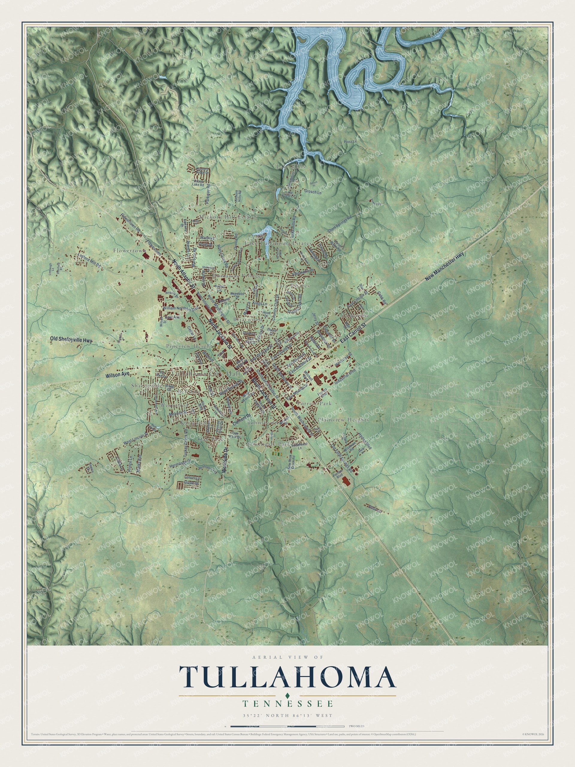
Tullahoma, Tennessee Map Art
Building by building, with labeled streets and shaded relief.
12" x 18" Archival Matte Print
A Map of Home. A Work of Art.
Explore Tullahoma, Tennessee from a whole new perspective. Created using aerial imagery and detailed geographic data, this map captures Tullahoma building by building, with labeled streets, familiar landmarks, and shaded topographical relief that highlights the natural contours of the landscape.
Combining modern data with the timeless character of a vintage atlas, this map is just as interesting up close as it is beautiful on the wall. Whether you grew up in Tullahoma, spent memorable years there, or call it home today, this unique map is a great way to celebrate a place that means something to you. Zoom in on the preview to look for your street, and then order a print to put your memories on the wall.
Three ways to hang it

Unframed archival matte, a black wood frame or a white wood frame.
Up close
Geography Worth Displaying
This map was created using accurate cartographic data and authoritative geographic sources, including the U.S. Geological Survey and the Census Bureau. The map brings together terrain, waterways, roads, and building detail. The majority of the streets are labeled, houses are accurately depicted, and the topography is derived from government sources. Combining local data with carefully composed color and shading leads to this beautifully detailed Tullahoma artwork for your wall.
Rather than simply showing street outlines, we’ve included as many of the street names as we could reasonably fit on the map while keeping their names legible. Zoom in on the high resolution preview to see exactly what’s on the map. We truly set out to create a statement piece for anyone who loves Tullahoma. So whether it’s for you, or a gift for someone you love, we hope this map of Tullahoma brings back fond memories.
Read the story behind this map of Tullahoma, Tennessee from 2026.

Find your street
Names on the Tullahoma map
Every name below is printed on this map. Look for your street, your school, the park where you played, or the pond down the road.
Places and landmarks19
- Tullahoma City Hall
- Lake Hills
- Anderson
- Flowertown
- Sharondale
- Hickory Hill Estates
- Briarwood
- Southgate Park
- Oak Park
- Forrest Park
- Tara Estates
- Pineview Heights
Show all 19 places
- Lake Tullahoma Estates
- Homaway Village
- Kaywood
- Bel-Aire
- Plainview Heights
- Westwood
- Johnstown
Streets and roads134
- East Carroll Street
- Westside Drive
- New Manchester Highway
- South Jackson Street
- North Jackson Street
- Wilson Avenue
- Old Shelbyville Highway
- North Atlantic Street
- Ovoca Road
- South Anderson Street
- Cedar Lane
- Old Estill Springs Road
- Lee Street
- Industrial Boulevard
- North Washington Street
- West Grundy Street
- East Avenue
- Country Club Drive
- Marbury
- West Lincoln Street
- East Lincoln Street
- Short Springs Road
- Ledford Mill Road
- Lake Hills Road
- East Grundy Street
- South Washington Street
- Turkey Creek Road
- Kings Lane
- Twelve Oaks Road
- Hermitage Drive
Show all 134 streets
- Harton Boulevard
- Flowertown Road
- Marbury Road
- Albemarle Drive
- Riley Creek Road
- Linda Lane
- East Decherd Street
- East Grizzard Street
- Parkway Road
- Prince Lane
- Southeast Atlantic Street
- William Northern Boulevard
- Wanda Lane
- East Monroe Street
- Montclair Street
- Freeman Street
- Melrose Street
- Forrest Drive
- Marks Avenue
- Cobb Road
- Helen Street
- Grosch Lane
- Broadrick Street
- Elise Circle
- Jerry Street
- Walker Street
- Point Drive
- Glade Drive
- Macs Lane
- Clement Drive
- Oak Park Drive
- Ovoca Lake Road
- East Fort Street
- West Warren Street
- Forrest Boulevard
- South Franklin Street
- Bel Aire Drive
- Bragg Circle
- East Warren Street
- Stone Boulevard
- New Rock Creek Road
- Wiseman Road
- Woodmont Drive
- Wilson Street
- Carter Blake Road
- Tara Boulevard
- Hunters Ridge Drive
- Mitchell Boulevard
- Ham Street
- Hickory Hills Road
- Weaver Street
- First Avenue
- Stuart Street
- West Hogan Street
- Huntington Place
- Regwood Drive
- Davidson Street
- Provins Drive
- Craft Lane
- Noblitt Lane
- Parham Boulevard
- Reeves Street
- Druid Lane
- Lake Crest Lane
- Airpark Drive
- Maplehill
- Vocational Lane
- Lemont Lane
- Hamilton Lane
- Larkway Drive
- Hood Drive
- Skyview Lane
- Pross Lane
- Scenic Drive
- Star Lane
- Kingsridge Boulevard
- East Moore Street
- Cumberland Avenue
- Meadowbrook Lane
- Lake Circle Drive
- Westside Heights Drive
- North Polk Street
- Sherwood Drive
- Ashley Drive
- Limbaugh Lane
- Deerfield Road
- Swift Lane
- Powell Road
- Lorraine Drive
- Blue Lake Drive
- Setters Lane
- Briar Lane
- North College Street
- Crosslake Drive
- Fairways Boulevard North
- Crest Drive
- South Roosevelt Street
- West Moore Street
- Johnson Lane
- Blantonwood Drive
- Deery Lane
- Grosch Street
- Chandelle Lane
- Troys Trail
Names are listed as they appear on the printed map. Zoom into the product photos to find them.
About Tullahoma, Tennessee
Tullahoma is a city of 20,339 people in Coffee County, and it reaches south into Franklin County. It began in 1852 as a work camp on the new Nashville and Chattanooga Railroad. The railroad picked the spot as the halfway point of its line and built large works there. It also ran a branch to Manchester and McMinnville that later reached coal mines and timber in White County.
In 1863 General Braxton Bragg made the town the headquarters of the Confederate Army of Tennessee, but he did little to fortify it. The Union Army's Tullahoma Campaign drove his forces out of Middle Tennessee. The Confederates left the town without a fight, and federal troops held the area for the rest of the war. Tullahoma recovered slowly after the war, but its railroad link brought prosperity, and it became known for its schools.
“Due to its importance as a rail center, both sides occupied Tullahoma at different times, destroying much of the original town.”
- Red rock or a favorite horseOne story traces the name to the Choctaw words for red rock. Another credits Peter Decherd, who gave land for the railroad and got to name two stations. He named one Decherd, for himself, and called the other Tulkahoma, later Tullahoma, after his favorite horse. The horse was named for a Choctaw chief whom Decherd's grandfather had captured. In the wet year of 1863, an officer on General William Hardee's staff joked that the name meant mud and more mud.
- The water at Big SpringsEarly settlers called the nearby spring Bottle Spring. Later it was John Gunn's Spring, because it sat on his land, and today it is Big Springs. Its water filled the railroad's steam locomotives. As the 20th century opened, visitors came to town for their health, and many spas around Tullahoma drew on the spring.
- Shoes, bats and baseballsInvestors started the General Shoe Corporation in Tullahoma, and it grew into Genesco, the oldest Tennessee company traded on the New York Stock Exchange. Local factories have turned out baseballs, bats and golf clubs since the early 1900s, for makers such as Campbell Mfg, Wilsons, Worth Sports and Rawlings.
- From Camp Forrest to ApolloCounty leaders offered free railroad land to win a military base, and Camp Forrest opened during World War II. It trained infantry and later held prisoners of war. After the war the Arnold Engineering Development Complex was built near town, with Woods Reservoir supplying its cooling water, and it helped develop the Mercury, Gemini and Apollo space programs. The state later added the University of Tennessee Space Institute and Motlow State Community College.
Keep exploring Tennessee
Tullahoma is one of 640 Tennessee towns we've mapped. Every dot on the map is a print of its own.
The search covers every state, Tennessee first.
Near Tullahoma
Order 2 or more town maps and save 10%. Shown in the size and finish you picked above, so they hang as a set.
- Normandy 12" x 18" / Archival Matte Print $39.99
- Estill Springs 12" x 18" / Archival Matte Print $39.99
- Lynchburg 12" x 18" / Archival Matte Print $39.99


More maps nearby: Manchester, Broadview, Wartrace, New Union and Decherd.
The art of mapping a place
How This Map Was Made
Real places. Remarkable detail. Discover the layers that turn geographic data into a map of home.

The view from above
Aerial imagery reveals the character of the land: woodland, open fields, and the patterns of a place.

The shape of the land
Elevation data brings hills, valleys, and subtle changes in the landscape into view.

The details of home
Roads, waterways, and building footprints come together to make the map feel unmistakably local.

Geography becomes art
Considered color, shading, and typography bring the layers together in a map made for your wall.


Process illustrated with Mendon, Massachusetts. Aerial imagery: USDA NAIP. Terrain: USGS 3D Elevation Program. Map details and finished artwork: KNOWOL.
The Details
About This Print
Choose an archival matte print, or a black or white Ayous wood frame. The archival matte print is unframed.
Select your size and finish above to see the matching product image and price.
Materials & Craftsmanship
A contemporary map with the character of a classic atlas, printed on archival matte paper. Optional frames are made from Ayous wood.
Your printed map does not include the watermark shown in the full-map preview.
Shipping & Delivery
Free shipping within the United States. Every print is made to order in the USA.
Buying a gift? Add a note in your cart and we'll include it. We never put prices in the package.
Prints ship within 2 to 3 business days. Allow 7 to 10 days total from ordering for delivery. Timing may vary during holidays or periods of high order volume.
Read our shipping policy.
Returns and damaged prints
Each print is made to order. Change-of-mind refunds are not available after production.
If your print arrives damaged, misprinted or incorrect, contact support@knowol.com within 30 days of receiving it. Include your order number, photos and a description of the issue.
Read our full refund and replacement policy. For questions about your order, email support@knowol.com.