


Search for another town


Free U.S. delivery 7 to 10 days after you order
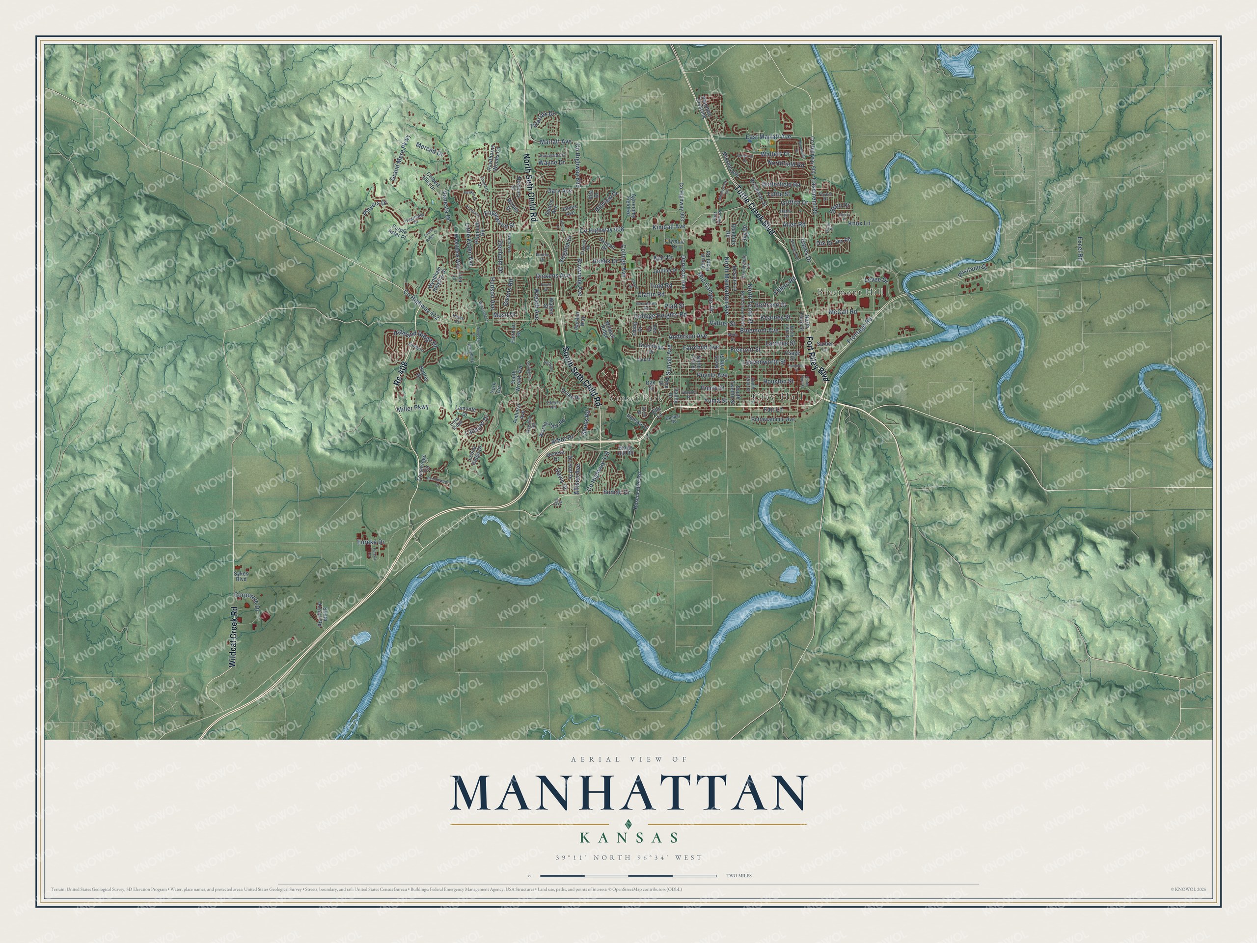
Manhattan, Kansas Map Art
Building by building, with labeled streets and shaded relief.
12" x 18" Archival Matte Print
A Map of Home. A Work of Art.
Explore Manhattan, Kansas from a whole new perspective. Created using aerial imagery and detailed geographic data, this map captures Manhattan building by building, with labeled streets, familiar landmarks, and shaded topographical relief that highlights the natural contours of the landscape.
Combining modern data with the timeless character of a vintage atlas, this map is just as interesting up close as it is beautiful on the wall. Whether you grew up in Manhattan, spent memorable years there, or call it home today, this unique map is a great way to celebrate a place that means something to you. Zoom in on the preview to look for your street, and then order a print to put your memories on the wall.
Three ways to hang it

Unframed archival matte, a black wood frame or a white wood frame.
Up close
Geography Worth Displaying
This map was created using accurate cartographic data and authoritative geographic sources, including the U.S. Geological Survey and the Census Bureau. The map brings together terrain, waterways, roads, and building detail. The majority of the streets are labeled, houses are accurately depicted, and the topography is derived from government sources. Combining local data with carefully composed color and shading leads to this beautifully detailed Manhattan artwork for your wall.
Rather than simply showing street outlines, we’ve included as many of the street names as we could reasonably fit on the map while keeping their names legible. Zoom in on the high resolution preview to see exactly what’s on the map. We truly set out to create a statement piece for anyone who loves Manhattan. So whether it’s for you, or a gift for someone you love, we hope this map of Manhattan brings back fond memories.
Read the story behind this map of Manhattan, Kansas from 2026.

Find your street
Names on the Manhattan map
Every name below is printed on this map. Look for your street, your school, the park where you played, or the pond down the road.
Places and landmarks4
- City Hall
- Bluemont Hill
- Sunset Park
- CiCo Park
Streets and roads190
- Fort Riley Boulevard
- Rc-408
- Wildcat Creek Road
- Tuttle Creek Boulevard
- North Seth Child Road
- South Seth Child Road
- Bluemont Avenue
- Kimball Avenue
- Anderson Avenue
- Frontage Road
- Poyntz Avenue
- North Manhattan Avenue
- Mid-Campus Drive
- County Highway 899
- Claflin Road
- County Highway 408
- Miller Parkway
- Denison Avenue
- Grand Mere Parkway
- Browning Avenue
- Pierre Street
- Highland Ridge Drive
- Dickens Avenue
- Casement Road
- College Avenue
- Laramie Street
- Hayes Drive
- Vanesta Drive
- Leavenworth Street
- North Tenth Street
Show all 190 streets
- Yuma Street
- Houston Street
- Vattier Street
- Fair Lane
- Little Kitten Avenue
- East Marlatt Avenue
- Gary Avenue
- County Highway 418
- Levee Drive
- Northfield Road
- Wreath Avenue
- Hudson Avenue
- Butterfield Road
- Fremont Street
- Sunset Avenue
- Walters Drive
- College Heights Road
- Kearney Street
- Merced Drive
- McCall Road
- Allison Avenue
- Corporate Drive
- Marlatt Avenue
- Bertrand Street
- Griffith Drive
- Tatarrax Drive
- Knox Lane
- Hillview Drive
- Fairchild Avenue
- Arbor Drive
- Virginia Drive
- County Highway 412
- Davis Drive
- Allen Road
- Todd Road
- Sumac Drive
- Hobbs Drive
- Players Drive
- Denholm Drive
- Englewood Street
- Kerr Drive
- Tuttle Street
- Givens Road
- Ivy Drive
- Laussac Drive
- Dix Drive
- Spain Drive
- Shuss Road
- Positano Drive
- Ehlers Road
- Eureka Drive
- Excel Road
- Wayne Drive
- Musil Drive
- Platt Street
- Pine Drive
- South Airport Road
- Amherst Avenue
- County Highway 903
- South Wreath Avenue
- Stagg Hill Road
- North 17th Street
- Osage Street
- North Third Street
- Jardine Drive
- Potomac Crossing
- Pottawatomie Avenue
- Plymouth Road
- Bluehills Road
- Colbert Hills Drive
- Warner Park Road
- Rosencutter Road
- Serum Plant Road
- Vaughn Drive
- Wyndham Heights Drive
- De Hoff Drive
- Mission Avenue
- Brockman Street
- County Highway 905
- Seaton Avenue
- Garden Way
- North 14th Street
- Westbank Way
- Poliska Lane
- Olympic Drive
- Agronomy Field Road
- Dix Road
- Newbury Street
- McCain Lane
- Grandview Drive
- James Avenue
- Fossilridge Circle
- South Twelfth Street
- Hawthorne Woods Circle
- Purple Aster Place
- Sarber Lane
- Leone Ridge Drive
- Wildcat Ridge
- Drake Drive
- Valley Drive
- Lamonte Drive
- Fairman Drive
- Woods Drive
- Waters Street
- Elling Drive
- Lee Street
- Hunter Drive
- Geneva Drive
- Alta Drive
- Oak Street
- Sykes Boulevard
- Lisa Lane
- York Circle
- Elm Lane
- North Eleventh Street
- Moro Street
- North Fifth Street
- Anneberg Circle
- Heartland Drive
- South Tenth Street
- Cassell Road
- Stone Drive
- Strong Avenue
- Avery Avenue
- Sunnyslope Lane
- Lundin Drive
- Flint Hills Place
- Sunnyside Drive
- Tecumseh Road
- Overhill Road
- Parker Drive
- Kates Court
- Park Drive
- Dunbar Road
- Everett Drive
- Cherry Hill
- Loma Ridge
- Hanly Street
- Cody Place
- Cox Circle
- Colorado Street
- Humboldt Street
- Brookville Drive
- Bamblewood Drive
- Eureka Terrace
- Meadowlark Road
- South Third Street
- Plymouth
- Goodrich Drive
- Starlight Lane
- Chase Place
- Windsong Lane
- Shelle Road
- Deakon Drive
- Anneberg Drive
- Shirley Lane
- Sherry Place
- Grand Ridge Court
- Payne Drive
- Bethany
Names are listed as they appear on the printed map. Zoom into the product photos to find them.
About Manhattan, Kansas
Manhattan is a city of 54,100 people and the county seat of Riley County, set where the Big Blue River joins the Kansas River. From 1780 to 1830 the Kaw people lived here at Blue Earth Village, and they gave up the land in a treaty signed on January 14, 1846. In 1854 George S. Park started a settlement called Polistra, while Samuel D. Houston and three other men founded Canton close by, but neither place grew past its founders.
In April 1855 Free-Staters from New England, led by Isaac Goodnow and sent by the New England Emigrant Aid Company, combined the two claims into one town called Boston. That June the steamboat Hartford ran aground nearby with 75 settlers from Ohio, who had meant to go farther up the river to the spot where Junction City stands today. The Boston settlers offered them half of the townsite, and the stranded passengers agreed to stay if the town took their chosen name. It became Manhattan on June 29, 1855, and it was incorporated on May 30, 1857.
- First public college in KansasGovernor James W. Denver chartered Manhattan's Methodist Blue Mont Central College on February 9, 1858. Once Kansas joined the Union in 1861, Isaac Goodnow, a former Rhode Island teacher, urged the legislature to make it the state university. Lawmakers created Kansas State Agricultural College here on February 16, 1863, and classes opened on September 2, 1863. It was the nation's first Morrill Act land-grant school and just the second public college open equally to men and women.
- Supplies for the Fifty-NinersManhattan stood firmly with the Free-State side and sent the only two Free-State members to the first Territorial Legislature. Nearby Fort Riley spared it the worst violence of Bleeding Kansas, so the town grew fast. When gold turned up in the Rocky Mountains in 1859, miners heading west bought their supplies from Manhattan merchants. The town's first newspaper, The Kansas Express, started on May 21, 1859, and the Kansas Pacific Railroad laid its tracks through town in 1866.
- Kansas's strongest earthquakeOn April 24, 1867, an earthquake measuring 5.1 struck with its center near Manhattan. It is still the strongest quake ever to start in Kansas, and people felt it across about 193,051 square miles, though it did mostly minor damage.
- The Little AppleManhattan's nickname plays on New York City's Big Apple. In 1952 the city won the All-America City Award, the first town in Kansas to receive it.
Keep exploring Kansas
Manhattan is one of 764 Kansas towns we've mapped. Every dot on the map is a print of its own.
The search covers every state, Kansas first.
Near Manhattan
Order 2 or more town maps and save 10%. Shown in the size and finish you picked above, so they hang as a set.
- Keats 12" x 18" / Archival Matte Print $39.99
- Ogden 12" x 18" / Archival Matte Print $39.99
- Zeandale 12" x 18" / Archival Matte Print $39.99


More maps nearby: St. George, Fort Riley, Riley, Wabaunsee and Grandview Plaza.
The art of mapping a place
How This Map Was Made
Real places. Remarkable detail. Discover the layers that turn geographic data into a map of home.

The view from above
Aerial imagery reveals the character of the land: woodland, open fields, and the patterns of a place.

The shape of the land
Elevation data brings hills, valleys, and subtle changes in the landscape into view.

The details of home
Roads, waterways, and building footprints come together to make the map feel unmistakably local.

Geography becomes art
Considered color, shading, and typography bring the layers together in a map made for your wall.


Process illustrated with Mendon, Massachusetts. Aerial imagery: USDA NAIP. Terrain: USGS 3D Elevation Program. Map details and finished artwork: KNOWOL.
The Details
About This Print
Choose an archival matte print, or a black or white Ayous wood frame. The archival matte print is unframed.
Select your size and finish above to see the matching product image and price.
Materials & Craftsmanship
A contemporary map with the character of a classic atlas, printed on archival matte paper. Optional frames are made from Ayous wood.
Your printed map does not include the watermark shown in the full-map preview.
Shipping & Delivery
Free shipping within the United States. Every print is made to order in the USA.
Buying a gift? Add a note in your cart and we'll include it. We never put prices in the package.
Prints ship within 2 to 3 business days. Allow 7 to 10 days total from ordering for delivery. Timing may vary during holidays or periods of high order volume.
Read our shipping policy.
Returns and damaged prints
Each print is made to order. Change-of-mind refunds are not available after production.
If your print arrives damaged, misprinted or incorrect, contact support@knowol.com within 30 days of receiving it. Include your order number, photos and a description of the issue.
Read our full refund and replacement policy. For questions about your order, email support@knowol.com.