
Search for another town


Free U.S. delivery 7 to 10 days after you order
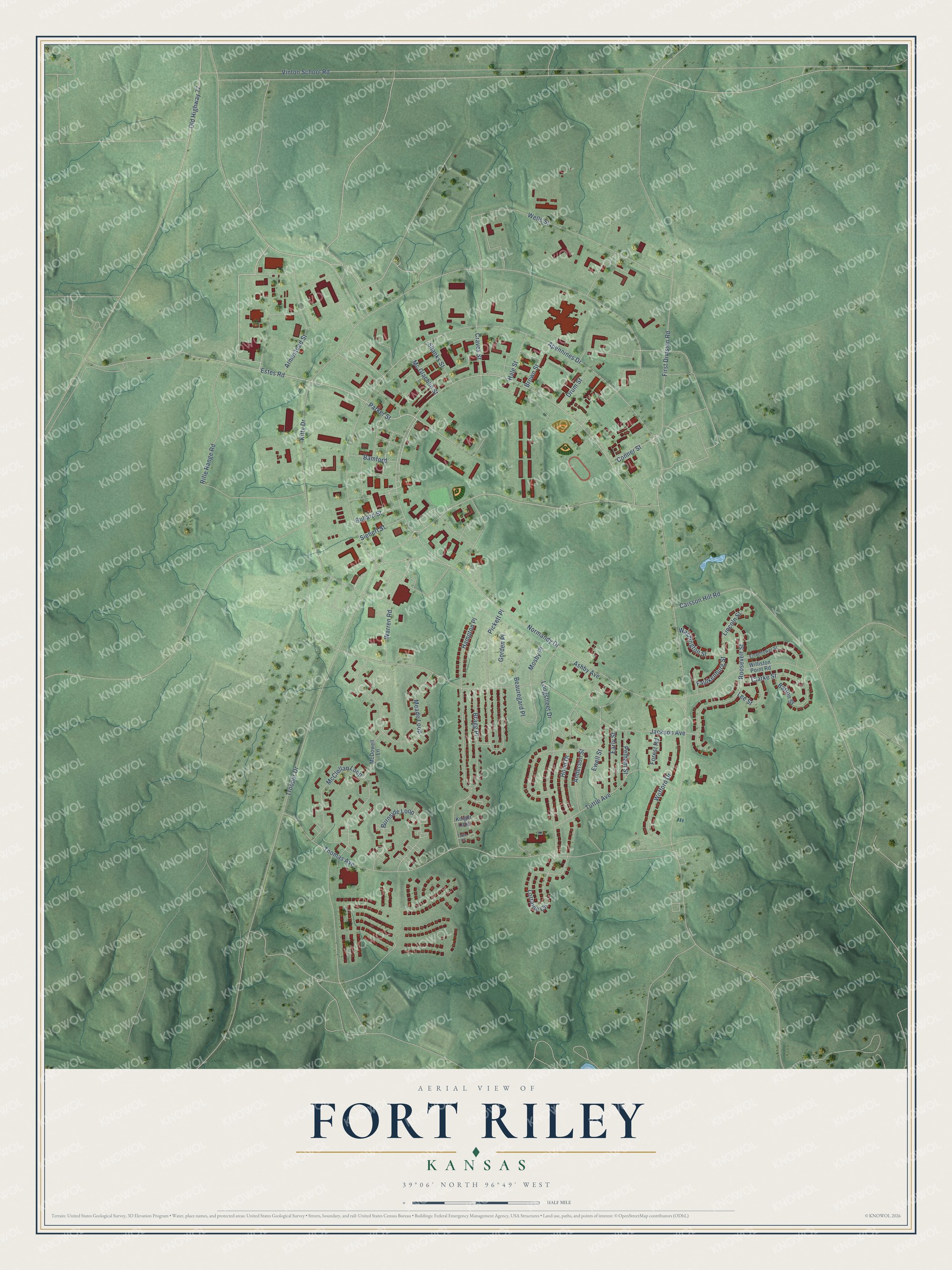
Fort Riley, Kansas Map Art
Building by building, with labeled streets and shaded relief.
12" x 18" Archival Matte Print
A Map of Home. A Work of Art.
Explore Fort Riley, Kansas from a whole new perspective. Created using aerial imagery and detailed geographic data, this map captures Fort Riley building by building, with labeled streets, familiar landmarks, and shaded topographical relief that highlights the natural contours of the landscape.
Combining modern data with the timeless character of a vintage atlas, this map is just as interesting up close as it is beautiful on the wall. Whether you grew up in Fort Riley, spent memorable years there, or call it home today, this unique map is a great way to celebrate a place that means something to you. Zoom in on the preview to look for your street, and then order a print to put your memories on the wall.
Three ways to hang it

Unframed archival matte, a black wood frame or a white wood frame.
Up close
Geography Worth Displaying
This map was created using accurate cartographic data and authoritative geographic sources, including the U.S. Geological Survey and the Census Bureau. The map brings together terrain, waterways, roads, and building detail. The majority of the streets are labeled, houses are accurately depicted, and the topography is derived from government sources. Combining local data with carefully composed color and shading leads to this beautifully detailed Fort Riley artwork for your wall.
Rather than simply showing street outlines, we’ve included as many of the street names as we could reasonably fit on the map while keeping their names legible. Zoom in on the high resolution preview to see exactly what’s on the map. We truly set out to create a statement piece for anyone who loves Fort Riley. So whether it’s for you, or a gift for someone you love, we hope this map of Fort Riley brings back fond memories.
Read the story behind this map of Fort Riley, Kansas from 2026.

Find your street
Names on the Fort Riley map
Every name below is printed on this map. Look for your street, your school, the park where you played, or the pond down the road.
Streets and roads58
- Parker Street
- Estes Road
- Normandy Drive
- Conner Street
- Apennines Drive
- First Division Road
- Trooper Drive
- McClellan Loop
- Craves Street
- Caisson Hill Road
- Burnside Loop
- Jackson Avenue
- Thomas Avenue
- Kitty Drive
- Vinton School Road
- Hampton Place
- Longstreet Drive
- Wells Street
- Meade Loop
- Ewell Street
- Roosevelt Street
- Hood Drive
- Tuttle Avenue
- Pickett Place
- Ashby Avenue
- Gorden Place
- Rifle Range Road
- Armestead Street
- Wofford Drive
- Warren Road
Show all 58 streets
- Bragg Place
- Lorraine Circle
- Beauregard Place
- Mosby Place
- Clarke Street
- Barton Street
- Old Highway 77
- Early Street
- Anderson Street
- Washington Street
- Lincoln Street
- Bullard Street
- Bamford
- Siebert Street
- Drum Street
- Hale Street
- Shanks Street
- Mc Glachlin Street
- Brown Street
- Lee Street
- Pelham Street
- Forest Road
- Faulkenburg Street
- Williston Point Road
- McDowell Lane
- Knight Loop
- Eisenhower Street
- Tobie Court
Names are listed as they appear on the printed map. Zoom into the product photos to find them.
About Fort Riley, Kansas
Fort Riley is an Army post on the Kansas River between Junction City and Manhattan, and 9,230 people lived in its housing area at the 2020 census. In the fall of 1852 Capt. Robert H. Chilton of the 1st U.S. Dragoons led a survey party to the spot where the Republican and Smoky Hill Rivers join. The surveyors thought the place lay close to the middle of the country, so they called it Camp Center, and three companies of the 6th Infantry moved in the next spring.
On June 27, 1853, the camp took the name of Maj. Gen. Bennet C. Riley, who in 1829 had commanded the first Army guard for traders on the Santa Fe Trail. Soldiers built the post from native limestone around a wide plain above the Kansas River valley. In July 1855 Capt. Edmund Ogden brought builders and wagons from Leavenworth to add quarters and stables, but cholera broke out and killed 70 people, Ogden among them. The crews slowly went back to work, and the buildings were ready when the 2nd Dragoons arrived in October.
- Custer and the 7th CavalryThe 7th Cavalry Regiment was mustered in at Fort Riley in 1866, the year the Union Pacific Railroad reached the post, and Brevet Maj. Gen. George A. Custer took command that December. The next spring he led the regiment across the plains of far western Kansas and into eastern Colorado. The campaign settled nothing, and Custer was court-martialed and suspended for a year, partly for leaving the field without leave to visit his wife at the fort.
- Saved by the Cavalry SchoolAs peace on the Great Plains closed many frontier forts, Lt. Gen. Philip Sheridan urged Congress in 1884 to make Riley the cavalry headquarters of the Army. Kansas lawmakers pressed the case, and in 1887 Congress set aside $200,000 for a permanent school for cavalry and light artillery. The money nearly rebuilt the post, adding a large riding hall, and the United States Army Cavalry School came to rank with the schools of France and Italy.
- The Life of RileyHunts, horse shows and polo grew naturally out of cavalry training here. Starting in 1921, the formally organized Cavalry School Hunt rode out in a colorful show each Sunday morning, and these pastimes earned the post its reputation for an easy, pleasant way of living, the Life of Riley.
- Home to the Buffalo SoldiersThe 9th and 10th Cavalry, the Buffalo Soldiers, served at Fort Riley several times. The 10th was posted here in 1868 and 1913. The 9th passed through after it formed in 1866, came back in the early 1880s and again early in the next century, and in the 1920s and 1930s it became the Cavalry School's permanent troop cadre.
- Camp Funston in 1917When America entered World War I, the Army built Camp Funston 5 miles east of the main post in the summer and fall of 1917. Commanded by Maj. Gen. Leonard Wood, it was one of 16 such camps in the country and could hold from 30,000 to 50,000 men. The 89th Division trained there first and left for France in the spring of 1918.
Keep exploring Kansas
Fort Riley is one of 764 Kansas towns we've mapped. Every dot on the map is a print of its own.
The search covers every state, Kansas first.
Near Fort Riley
Order 2 or more town maps and save 10%. Shown in the size and finish you picked above, so they hang as a set.
- Grandview Plaza 12" x 18" / Archival Matte Print $39.99
- Junction City 12" x 18" / Archival Matte Print $39.99
- Ogden 12" x 18" / Archival Matte Print $39.99


More maps nearby: Milford, Keats, Manhattan, Riley and Wakefield.
The art of mapping a place
How This Map Was Made
Real places. Remarkable detail. Discover the layers that turn geographic data into a map of home.

The view from above
Aerial imagery reveals the character of the land: woodland, open fields, and the patterns of a place.

The shape of the land
Elevation data brings hills, valleys, and subtle changes in the landscape into view.

The details of home
Roads, waterways, and building footprints come together to make the map feel unmistakably local.

Geography becomes art
Considered color, shading, and typography bring the layers together in a map made for your wall.


Process illustrated with Mendon, Massachusetts. Aerial imagery: USDA NAIP. Terrain: USGS 3D Elevation Program. Map details and finished artwork: KNOWOL.
The Details
About This Print
Choose an archival matte print, or a black or white Ayous wood frame. The archival matte print is unframed.
Select your size and finish above to see the matching product image and price.
Materials & Craftsmanship
A contemporary map with the character of a classic atlas, printed on archival matte paper. Optional frames are made from Ayous wood.
Your printed map does not include the watermark shown in the full-map preview.
Shipping & Delivery
Free shipping within the United States. Every print is made to order in the USA.
Buying a gift? Add a note in your cart and we'll include it. We never put prices in the package.
Prints ship within 2 to 3 business days. Allow 7 to 10 days total from ordering for delivery. Timing may vary during holidays or periods of high order volume.
Read our shipping policy.
Returns and damaged prints
Each print is made to order. Change-of-mind refunds are not available after production.
If your print arrives damaged, misprinted or incorrect, contact support@knowol.com within 30 days of receiving it. Include your order number, photos and a description of the issue.
Read our full refund and replacement policy. For questions about your order, email support@knowol.com.