
Search for another town


Free U.S. delivery 7 to 10 days after you order
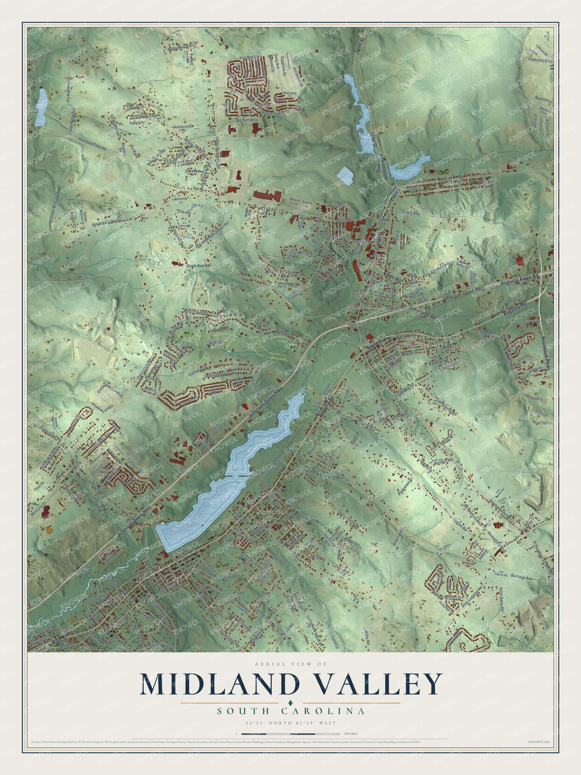
Midland Valley, South Carolina Map Art
Building by building, with labeled streets and shaded relief.
12" x 18" Archival Matte Print
A Map of Home. A Work of Art.
Explore Midland Valley, South Carolina from a whole new perspective. Created using aerial imagery and detailed geographic data, this map captures Midland Valley building by building, with labeled streets, familiar landmarks, and shaded topographical relief that highlights the natural contours of the landscape.
Combining modern data with the timeless character of a vintage atlas, this map is just as interesting up close as it is beautiful on the wall. Whether you grew up in Midland Valley, spent memorable years there, or call it home today, this unique map is a great way to celebrate a place that means something to you. Zoom in on the preview to look for your street, and then order a print to put your memories on the wall.
Three ways to hang it

Unframed archival matte, a black wood frame or a white wood frame.
Up close
Geography Worth Displaying
This map was created using accurate cartographic data and authoritative geographic sources, including the U.S. Geological Survey and the Census Bureau. The map brings together terrain, waterways, roads, and building detail. The majority of the streets are labeled, houses are accurately depicted, and the topography is derived from government sources. Combining local data with carefully composed color and shading leads to this beautifully detailed Midland Valley artwork for your wall.
Rather than simply showing street outlines, we’ve included as many of the street names as we could reasonably fit on the map while keeping their names legible. Zoom in on the high resolution preview to see exactly what’s on the map. We truly set out to create a statement piece for anyone who loves Midland Valley. So whether it’s for you, or a gift for someone you love, we hope this map of Midland Valley brings back fond memories.
Read the story behind this map: Detailed Map of Midland Valley, South Carolina.

Find your street
Names on the Midland Valley map
Every name below is printed on this map. Look for your street, your school, the park where you played, or the pond down the road.
Places and landmarks8
- Gregg Park
- Gloverville
- Warrenville
- Mixville
- Graniteville
- Stiefeltown
- Madison
- Mansell Park
Streets and roads335
- Canal Street
- Aiken Road
- Augusta Road
- Jefferson Davis Highway
- Augusta Aiken Road
- Hitchcock Parkway
- Senn Street
- Main Street
- Aiken Avenue
- Greenville Road
- Ascauga Lake Road
- Jerry Road
- Cathy Drive
- Burnett Street
- Railroad Avenue
- Granite Drive
- Baker Street
- Howlandville Road
- Marshall Street
- Connector Road
- Trolley Line Road
- Gregg Street
- Richardson's Lake Road
- Road 473
- Rusty Lane
- Carline Road
- Campbell Street
- Anthony Drive
- Ergle Street
- Oak Street
Show all 335 streets
- Joy Street
- Mack Lane
- Bayberry Street
- Chalk Bed Road
- Pine Street
- Legion Road
- Hillman Street
- Whaley Pond Road
- Langley Dam Road
- Pine Logging Road
- Gregg Highway
- Bettis Academy Road
- Rainbow Falls Road
- Grace-Hurst Road
- Midland Drive
- Sudlow Lake Road
- Schley Street
- Flat Rock Lane
- Piney Heights Road
- Sage Creek Boulevard
- Wickham Drive
- Hillview Drive
- Project Road
- Glover Street
- County Highway 23
- Sandy Ridge Road
- Laurel Drive
- Callaway Drive
- De Medicis Boulevard
- Demedicis Boulevard
- Church Street
- Leitner Street
- Summer Breeze Drive
- Huber Clay Road
- Cemetery Road
- Old Cherokee Indian Road
- Oxpens Road
- Cemetery Drive
- Edgar Street
- Golf Course Road
- Mustang Drive
- Jasmine Drive
- Breezy Hill Road
- Myrtle Street
- Ackerman Drive
- Country Glen Avenue
- Harper Valley Lane
- Wayland Street
- Keith Drive
- Burbage Avenue
- Tess Street
- Pleasant Pointe Lane
- Fairmont Drive
- Fioli Circle
- Second Street
- Camden Way
- Keys Dairy Road
- Coal Creek Drive
- Breezy Hill Drive
- Warren Street
- Midland Pines Drive
- Chaffee Street
- Elizabeth Street
- Saddlebrook Trail
- East Avenue
- Manitou Circle
- Pelzer Street
- Brevard Drive
- Wando Ridge Drive
- Walker Street
- Hillvale Street
- Geranium Street
- Birdie Place
- Weldon Way
- Aiken Boulevard
- Breeze Hill Road
- High Top Lane
- Burnhill Road
- Fourth Street
- County Highway 25
- Kaney Lane
- Cato Road
- Sugar Hill Drive
- Parker Street
- Ridgecrest Road
- Cozy Knl
- Sutton Court
- Catenary Boulevard
- Dunbar Street
- Jon Road
- Victory Lane
- County Highway 89
- Prides Crossing
- Hester Street
- Harrison Road
- County Highway 119
- Hatcher Drive
- Railroad Street
- Dwyer Lane
- Sapphire Drive
- Charles Street
- Holly Meadows Drive
- Donald Pearson Drive
- Third Street
- Madelyn Drive
- Green Street
- Grayson Drive
- Crossbow Landing
- County Highway 103
- Pride Avenue
- Samuels Street
- Drennan Drive
- Lee Drive
- Crossroads Drive
- Bath Lake Road
- Dewey Street
- James Street
- Fairway Drive
- Orion Street
- Webtar Lane
- Hard Street
- Almond Drive
- Tutt Street
- Alley Street
- Dibble Road
- Buttercup Lane
- Boatwright Drive
- Highland Drive
- Marshal Street
- Whaley Street
- Toby Lane
- First Street
- Johnson Street
- Drake Street
- Pecan Street
- Hubert Street
- Barrett Street
- Fenwick Street
- Monroe Street
- Lady Street
- Pond Row
- Monarch Street
- Willis Road
- Carter Street
- Plainview Drive
- Ashley Drive
- Les Drive
- Creek Street
- Jay Place
- Anmore Court
- Yo Road
- Fortune Road
- Robbe Street
- Laird Lane
- High Street
- Marie Drive
- Sims Street
- Delta Lane
- Old Graniteville Highway
- Mason Plantation Road
- Nolana Loop
- Dibble Road South West
- Mount Arthur Drive
- Langley Cemetery Road
- County Highway 250
- Bethlehem Circle
- Justin Street
- Roundstone Drive
- Furlong Circle
- Saint Johns Place
- Stephens Road
- Posey Street
- Honors Circle
- Freeman Street
- Winding Trail Road
- Fordham Drive
- Turning Crest Lane
- Chickory Street
- Henson Drive
- Pleasure Island Road
- Raleigh Drive
- Lytham Drive
- Broadsword Way
- Mill Street
- Archard Street
- Goldenrod Way
- County Highway 2099
- Climbing Rose Boulevard
- County Highway 179
- Kenneth Drive
- Elm Street
- Louise Street
- Royal Pine Drive
- Serenity Lane
- Gray Catbird Way
- Rhoden Street
- Old Trolley Line Road
- Back Street
- Gray Street
- Stone Pass Drive
- Oval Terrace
- Raiford Loop
- Dodge Street
- Gentry Hill Road
- Little Pines Court
- Whitney Street
- Jackson Street
- Hilltop Drive
- Oakwood Drive
- Sandersville Road
- Crabapple Lane
- Filyaw Acres Lane
- Courtland Drive
- Wythe Drive
- Pineview Drive
- Sleepy Hollow Lane
- Ferree Place
- Dummy Line Road
- Camp Kiwanis Lane
- Posner Street
- Boyd Drive
- Line Street
- Laurel Avenue
- Quartz Lane
- Pyatt Lane
- Abner Street
- Pine Hill Drive
- Abear Street
- Aiken Street
- Shirt Lane
- Laurel Circle
- Hill Street
- Ph Road
- Valley Homes Circle
- Dunbar Street Extended
- County Highway 1272
- Jim Cagney Road
- White Gate Loop
- Ergle Street Extended
- Ella Quiller Road
- Rockwell Court
- Samuels Country Lane
- Sherwood Forest Drive
- Oxford Street
- County Highway 177
- Avondale Lane
- Mahogany Terrace
- Murphy Street
- Powell Street
- Fern Crest Lane
- Red Rock Way
- Rye Field Road
- Buttonwood Drive
- Luxborough Court
- Hickman Street
- Old Hadden Road
- Lands End Drive
- Drive in Road
- Road 1522
- Goldfish Lane
- Band Box Avenue
- Marble Hill Road
- Walton Road
- Fannie Lane
- Spring Drive
- Merlin Lane
- Viceroy Lane
- Bald Eagle Court
- Tender Path
- Burkett Drive
- Mint Street
- Arnold Drive
- County Highway 175
- Southern View Drive
- Everdale Pass
- Olive Heights Road
- School Street
- County Highway 2107
- Thimbleberry Drive
- Ralph Greene Drive
- Carmine Avenue
- Gentry Street
- Kalmia Apts Drive
- Kissing Creek Run
- Kentbury Court
- Taylor Plantation Lane
- Woodview Drive
- Proud Pacer Drive
- County Highway 93
- New Reames Road
- Polatty Street
- Beadlow Street
- Swallowtail Lane
- New Street
- Farfour Lane
- Madawa Drive
- Twin View Court
- Lucille Drive
- Hester Lane
- Elbert Street
- Rabbit Hill Road
- Mackey Court
- Henry Street
- Tintern Trail
- White Way
Names are listed as they appear on the printed map. Zoom into the product photos to find them.
Keep exploring South Carolina
Midland Valley is one of 540 South Carolina towns we've mapped. Every dot on the map is a print of its own.
The search covers every state, South Carolina first.
Near Midland Valley
Order 2 or more town maps and save 10%. Shown in the size and finish you picked above, so they hang as a set.
- Graniteville 12" x 18" / Archival Matte Print $39.99
- Warrenville 12" x 18" / Archival Matte Print $39.99
- Gloverville 12" x 18" / Archival Matte Print $39.99


More maps nearby: Langley, Burnettown, Bath, Aiken and Clearwater.
The art of mapping a place
How This Map Was Made
Real places. Remarkable detail. Discover the layers that turn geographic data into a map of home.

The view from above
Aerial imagery reveals the character of the land: woodland, open fields, and the patterns of a place.

The shape of the land
Elevation data brings hills, valleys, and subtle changes in the landscape into view.

The details of home
Roads, waterways, and building footprints come together to make the map feel unmistakably local.

Geography becomes art
Considered color, shading, and typography bring the layers together in a map made for your wall.


Process illustrated with Mendon, Massachusetts. Aerial imagery: USDA NAIP. Terrain: USGS 3D Elevation Program. Map details and finished artwork: KNOWOL.
The Details
About This Print
Choose an archival matte print, or a black or white Ayous wood frame. The archival matte print is unframed.
Select your size and finish above to see the matching product image and price.
Materials & Craftsmanship
A contemporary map with the character of a classic atlas, printed on archival matte paper. Optional frames are made from Ayous wood.
Your printed map does not include the watermark shown in the full-map preview.
Shipping & Delivery
Free shipping within the United States. Every print is made to order in the USA.
Buying a gift? Add a note in your cart and we'll include it. We never put prices in the package.
Prints ship within 2 to 3 business days. Allow 7 to 10 days total from ordering for delivery. Timing may vary during holidays or periods of high order volume.
Read our shipping policy.
Returns and damaged prints
Each print is made to order. Change-of-mind refunds are not available after production.
If your print arrives damaged, misprinted or incorrect, contact support@knowol.com within 30 days of receiving it. Include your order number, photos and a description of the issue.
Read our full refund and replacement policy. For questions about your order, email support@knowol.com.