
Search for another town


Free U.S. delivery 7 to 10 days after you order
Milltown, Somerset County, New Jersey Map Art
Building by building, with labeled streets and shaded relief.
12" x 18" Archival Matte Print
A Map of Home. A Work of Art.
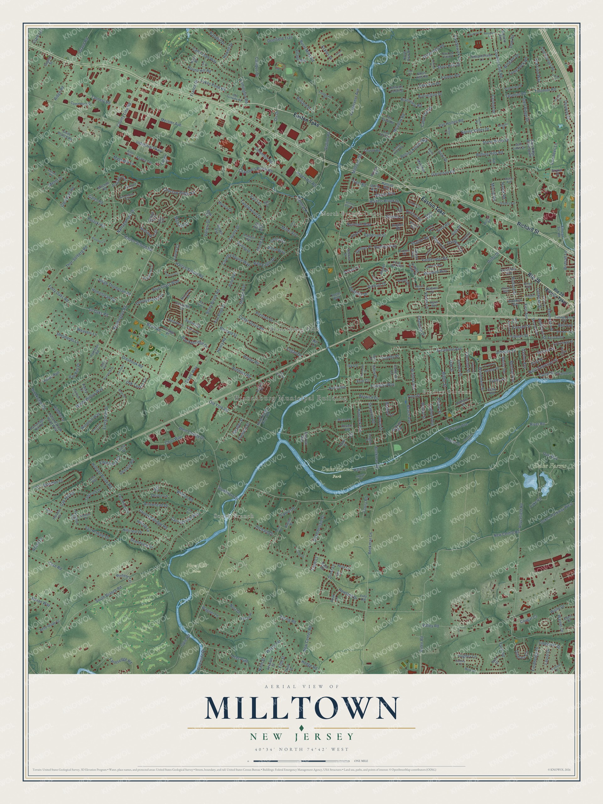
Explore Milltown, New Jersey from a whole new perspective. Created using aerial imagery and detailed geographic data, this map captures Milltown building by building, with labeled streets, familiar landmarks, and shaded topographical relief that highlights the natural contours of the landscape.
Combining modern data with the timeless character of a vintage atlas, this map is just as interesting up close as it is beautiful on the wall. Whether you grew up in Milltown, spent memorable years there, or call it home today, this unique map is a great way to celebrate a place that means something to you. Zoom in on the preview to look for your street, and then order a print to put your memories on the wall.
Three ways to hang it

Unframed archival matte, a black wood frame or a white wood frame.
Up close
Geography Worth Displaying
This map was created using accurate cartographic data and authoritative geographic sources, including the U.S. Geological Survey and the Census Bureau. The map brings together terrain, waterways, roads, and building detail. The majority of the streets are labeled, houses are accurately depicted, and the topography is derived from government sources. Combining local data with carefully composed color and shading leads to this beautifully detailed Milltown artwork for your wall.
Rather than simply showing street outlines, we’ve included as many of the street names as we could reasonably fit on the map while keeping their names legible. Zoom in on the high resolution preview to see exactly what’s on the map. We truly set out to create a statement piece for anyone who loves Milltown. So whether it’s for you, or a gift for someone you love, we hope this map of Milltown brings back fond memories.
Read the story behind this map: Detailed Map of Milltown, Somerset County, New Jersey.

Find your street
Names on the Milltown map
Every name below is printed on this map. Look for your street, your school, the park where you played, or the pond down the road.
Places and landmarks8
- Branchburg Municipal Building
- South Branch
- Bradley Gardens
- North Branch Depot
- Duke Farms
- Duke Island Park
- Norz Hill Farm
- Branchburg Park
Streets and roads410
- Route 28
- Easton Turnpike
- Richard Street
- River Road
- First Avenue
- Park Drive
- Sunset Street
- Walters Brook Drive
- Canal Street
- Shaffer Road
- Forty Oaks Road
- West Somerset Street
- Old York Road
- South Branch Road
- Readington Road
- Milltown Road
- County Line Road
- Country Club Road
- Stony Brook Road
- Roycefield Road
- Whiton Road
- Beekman Lane
- Garretson Road
- Valley Road
- New Center Road
- Vanderveer Road
- New Centre Road
- Station Road
- Orchard Drive
- Meadow Road
Show all 410 streets
- Meister Avenue
- Harlan School Road
- Windy Willow Way
- Thor-Solberg Road
- Van Holten Road
- West County Drive
- Deer Path
- Cedar Grove Road
- Ridge Road
- Burnt Mills Road
- Stony Brook Drive
- Campus Drive
- Hillcrest Drive
- Pulaski Road
- Chambers Brook Road
- Industrial Parkway
- Robbins Road
- Case Road
- Narragansett Drive
- Brandon Court
- Auten Road
- Brahma Avenue
- Doolittle Drive
- Vanderveer Avenue
- Bernard Street
- Chamberlain Drive
- Vones Lane
- 40 Oaks Road
- Ivy Lane
- Round Hill Road
- Patterson Street
- Norz Drive
- Lamington Road
- Bradley Lane
- Weavers Lane
- Leghorn Avenue
- Holland Brook Road
- Sycamore Avenue
- Talamini Road
- Tolomini Road
- Rolling Knolls Way
- Maple Street
- Pinhorn Drive
- Arrowhead Drive
- Oak Street
- Preston Drive
- Vollers Drive
- Rolling Hills Road
- Thompson Street
- Indian Run
- Miller Avenue
- Dukes Parkway West
- Shields Lane
- Covered Bridge Road
- Ortho Drive
- Baird Road
- Chestnut Street
- Choctaw Ridge Road
- Huyler Road
- Farmer Road
- County Drive
- Tanglewood Drive
- Carol Jean Way
- Linden Street
- Ronan Way
- Magnolia Lane
- Farmsedge Road
- Hancock Avenue
- Van Arsdale Drive
- Riverside Drive
- Opie Road
- Brookview Road
- Short Hills Drive
- Windmill Way
- Riverview Road
- Blue Grass Boulevard
- Lindstrom Drive
- Tannery Road
- Chub Way
- Carlene Drive
- Thruway Drive
- Thoroughbred Drive
- Country Squire Way
- Oriole Lane
- Drost Lane
- Grandview Drive
- Harlen School Road
- Flanders Way
- Shepherds Lane
- Anderson Street
- Lyme Rock Road
- Red Lion Way
- Candlewick Lane
- Ditmars Circle
- Mohawk Trail
- Ninth Street
- Great Hills Road
- Carroll Drive
- Rowland Drive
- Lukes Pond Road
- Charlotte Drive
- Oak Tavern Circle
- Judge Thompson Road
- Dreahook Road
- Vail Terrace
- Duval Street
- Beekman Road
- Evergreen Drive
- Evans Way
- Voorhees Lane
- Wagner Lane
- Weiss Terrace
- Reinhart Way
- Woodmere Street
- Hughey Lane
- Beach Avenue
- Island Road
- Breckenridge Drive
- Pine Street
- Elmara Drive
- Van Pelt Drive
- Shannon Road
- Homestead Road
- Cabot Hill Road
- Howell Drive
- Timothy Place
- Oak Way
- Wayne Avenue
- Huntley Way
- Bald Eagle Drive
- Eckles Drive
- Robert Street
- Oak Hill Road
- Spring Valley Drive
- Eyring Road
- Johnson Drive
- Second Street
- Meehan Avenue
- Edgewood Road
- Fifth Street
- Sharon Avenue
- Bell Avenue
- Peters Terrace
- Marcia Way
- North Avenue
- Barrington Drive
- Carriage Hill Way
- Farm Road
- Wingate Drive
- France Drive
- Fieldhedge Drive
- Deer Run Drive
- Laurel Drive
- Dow Road
- Glen Ridge Drive
- Jarman Place
- Bluebird Way
- Danberry Lane
- Deerfield Trail
- Katydid Drive
- Lynwood Street
- Cope Court
- Henry Road
- Gates Road
- Wren Way
- Aspen Hill Road
- Menlo Drive
- Berwick Drive
- Columbia Road
- Gaston Avenue
- Glenmont Road
- Cougar Court
- Lake Road
- Farrand Street
- Wolfe Drive
- Studdiford Drive
- Orr Drive
- Vicki Drive
- Walnut Street
- Rolland Drive
- Warner Drive
- Tysley Place
- Hauck Road
- Vista Road
- Hodge Road
- Birdsall Lane
- Tiffin Place
- Tillman Street
- Fremont Street
- Coury Road
- Purcell Road
- Clark Lane
- Shaffer Street
- Michael Court
- Villa Drive
- Acorn Lane
- Devon Lane
- Deerhill Road
- Poplar Street
- Milcrip Road
- Traci Road
- First Street
- Hidden Lane
- Hilltop Lane
- Laurel Court
- Central Place
- Logan Drive
- Pine Avenue
- Erin Court
- Vroom Drive
- North Branch River Road
- Ardmaer Drive
- Glen Ridge Drive South
- Ethicon Svc Road
- Winder Drive
- Short Hills Road
- Arapaho Trail
- Saint Georges Road
- Holland Brook Road West
- Mahnken Drive
- Second Avenue
- Steeplechase Lane
- McBride Way
- Starling Drive
- Belle Glade Court
- Cascades Terrace
- Village Way
- Steven Avenue
- Orlando Drive
- Hamilton Road
- Church Road
- Bush Road
- Commerce Street
- Parsonage Hill Road
- Stech Drive
- Pine Ridge Drive
- Tamarack Drive
- Helene Place
- Mitchell Road
- Janine Way
- Smith Branch Road
- Hannah Way
- Third Street
- Kiser Lane
- Century Lane
- Lexington Avenue
- Columbus Avenue
- La Grange Street
- Twin Pines Lane
- Catherine Lane
- Golf Links Drive
- Culnen Drive
- Heitz Lane
- Fellen Place
- Brusler Place
- Helfreds Landing
- Stryker Court
- Winfield Terrace
- Red Oak Way
- Natures Lane
- Frey Road
- Azalea Terrace
- Hidden Pond Court
- Brokaw Court
- Monica Court
- Ten Eyck Road
- Colmart Way
- Peak Lane
- Kiva Place
- Brooklyn Avenue
- North View Drive
- Ottawa Trail
- Barbieri Court
- Ventura Drive
- Ebert Drive
- Revere Avenue
- Garfield Avenue
- Colby Avenue
- Harvest Drive
- Kacey Court
- Seventh Street
- Stoll Drive
- Cottage Place
- Hill Lane
- Shale Hill Road
- Hughes Road
- Keeler Boulevard
- Sophie Street
- Fern Court
- Duke Court
- Circle Drive
- Dow Place
- Mill Lane
- Fieldpointe Drive
- More Road
- Kenbury Road
- Strawbridge Street
- Wexford Way
- Sherman Avenue
- Champions Circle
- Delaware Lane
- Buena Parkway
- Fawn Run Lane
- Old Turnpike Road
- Rectory Road
- Rhine Boulevard
- Cardinal Way
- Gregory Avenue
- Frelinghuysen Avenue
- Alletra Avenue
- Snowbird Way
- Perlee Avenue
- Jaycee Road
- Stratford Lane
- Railroad Avenue
- Macintosh Road
- Porter Way West
- Andover Drive
- Moray Avenue
- Stapleton Court
- King Drive
- Lincoln Street
- Forest Lane
- Cold Spring Lane
- Edison Road
- Orion Way
- Mohawk Road
- O'Keefe Road
- Sargeant Street
- Alpine Way
- Obert Drive
- Reagan Drive
- Yuma Trail
- Gafney Court
- Lee Place
- Arbor Way
- Kyle Court
- Falls Road
- Darby Place
- Young Way
- Winthrop Road
- Susquehanna Trail
- Farrington Lane
- Preakness Circle
- Bayley Court
- Ashton Street
- Mary Lynn Lane
- White Oak Ridge Road
- Sutton Court
- Bertram Drive
- Moorhouse Court
- Woodside Lane
- Quick Avenue
- Arnold Avenue
- Gregory Lane
- Darcy Drive
- Roosevelt Street
- Raritan Avenue
- Roderer Drive
- Manchester Drive
- Presidents Drive
- Falmouth Place
- Brookview Court
- Blackberry Lane
- Edgewater Avenue
- Southland Drive
- Libby Lane
- Prospect Place
- Winding Brook Way
- Foxcroft Road
- Raker Court
- Benner Court
- Herder Drive
- Fairway Court
- Crater Road
- Walter's Brook Drive
- Van Dyke Road
- Elia Drive
- Falcon Court
- Leah Court
Names are listed as they appear on the printed map. Zoom into the product photos to find them.
Keep exploring New Jersey
Milltown is one of 990 New Jersey towns we've mapped. Every dot on the map is a print of its own.
The search covers every state, New Jersey first.
Near Milltown
Order 2 or more town maps and save 10%. Shown in the size and finish you picked above, so they hang as a set.
- Bradley Gardens 12" x 18" / Archival Matte Print $39.99
- Branchburg 12" x 18" / Archival Matte Print $39.99
- Raritan 12" x 18" / Archival Matte Print $39.99


More maps nearby: Bridgewater Center, Flagtown, Neshanic Station, Somerville and Green Knoll.
The art of mapping a place
How This Map Was Made
Real places. Remarkable detail. Discover the layers that turn geographic data into a map of home.

The view from above
Aerial imagery reveals the character of the land: woodland, open fields, and the patterns of a place.

The shape of the land
Elevation data brings hills, valleys, and subtle changes in the landscape into view.

The details of home
Roads, waterways, and building footprints come together to make the map feel unmistakably local.

Geography becomes art
Considered color, shading, and typography bring the layers together in a map made for your wall.


Process illustrated with Mendon, Massachusetts. Aerial imagery: USDA NAIP. Terrain: USGS 3D Elevation Program. Map details and finished artwork: KNOWOL.
The Details
About This Print
Choose an archival matte print, or a black or white Ayous wood frame. The archival matte print is unframed.
Select your size and finish above to see the matching product image and price.
Materials & Craftsmanship
A contemporary map with the character of a classic atlas, printed on archival matte paper. Optional frames are made from Ayous wood.
Your printed map does not include the watermark shown in the full-map preview.
Shipping & Delivery
Free shipping within the United States. Every print is made to order in the USA.
Buying a gift? Add a note in your cart and we'll include it. We never put prices in the package.
Prints ship within 2 to 3 business days. Allow 7 to 10 days total from ordering for delivery. Timing may vary during holidays or periods of high order volume.
Read our shipping policy.
Returns and damaged prints
Each print is made to order. Change-of-mind refunds are not available after production.
If your print arrives damaged, misprinted or incorrect, contact support@knowol.com within 30 days of receiving it. Include your order number, photos and a description of the issue.
Read our full refund and replacement policy. For questions about your order, email support@knowol.com.