
Search for another town


Free U.S. delivery 7 to 10 days after you order
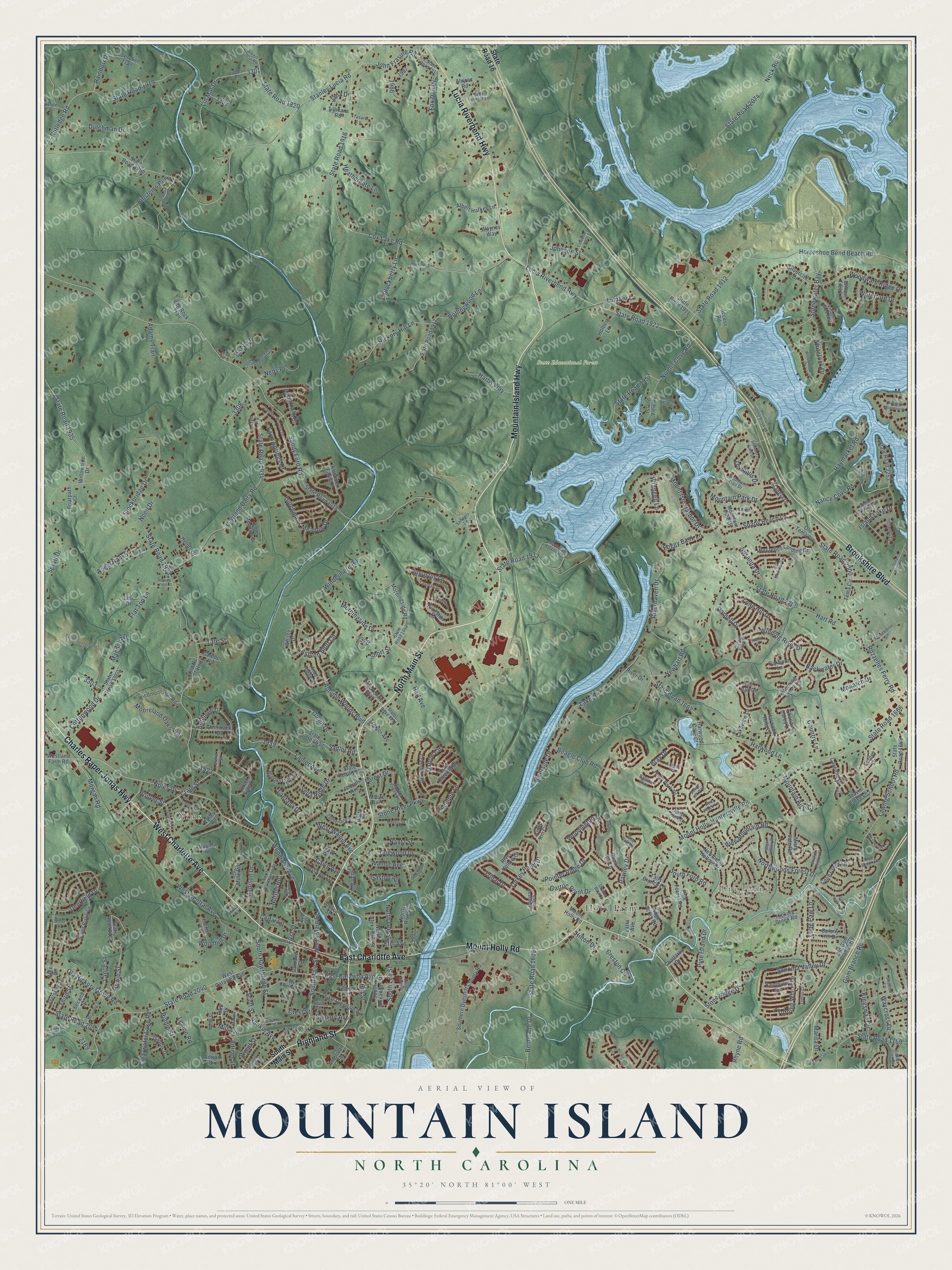
Mountain Island, North Carolina Map Art
Building by building, with labeled streets and shaded relief.
12" x 18" Archival Matte Print
A Map of Home. A Work of Art.
Explore Mountain Island, North Carolina from a whole new perspective. Created using aerial imagery and detailed geographic data, this map captures Mountain Island building by building, with labeled streets, familiar landmarks, and shaded topographical relief that highlights the natural contours of the landscape.
Combining modern data with the timeless character of a vintage atlas, this map is just as interesting up close as it is beautiful on the wall. Whether you grew up in Mountain Island, spent memorable years there, or call it home today, this unique map is a great way to celebrate a place that means something to you. Zoom in on the preview to look for your street, and then order a print to put your memories on the wall.
Three ways to hang it

Unframed archival matte, a black wood frame or a white wood frame.
Up close
Geography Worth Displaying
This map was created using accurate cartographic data and authoritative geographic sources, including the U.S. Geological Survey and the Census Bureau. The map brings together terrain, waterways, roads, and building detail. The majority of the streets are labeled, houses are accurately depicted, and the topography is derived from government sources. Combining local data with carefully composed color and shading leads to this beautifully detailed Mountain Island artwork for your wall.
Rather than simply showing street outlines, we’ve included as many of the street names as we could reasonably fit on the map while keeping their names legible. Zoom in on the high resolution preview to see exactly what’s on the map. We truly set out to create a statement piece for anyone who loves Mountain Island. So whether it’s for you, or a gift for someone you love, we hope this map of Mountain Island brings back fond memories.
Read the story behind this map: Detailed Map of Mountain Island, North Carolina.

Find your street
Names on the Mountain Island map
Every name below is printed on this map. Look for your street, your school, the park where you played, or the pond down the road.
Places and landmarks4
- Pine Island
- Nims
- State Educational Forest
- Hope Farm
Streets and roads356
- Mountain Island Highway
- West Charlotte Avenue
- Highland Street
- Charles Raper Jonas Highway
- East Charlotte Avenue
- Brookshire Boulevard
- Mount Holly Road
- North Main Street
- Lucia Riverbend Highway
- Woodlawn Avenue
- State Road 1933
- Noles Drive
- South Main Street
- Craig Street
- Hoover Street
- Augustus Lane
- East Catawba Avenue
- State Road 1922
- Sonoma Valley Drive
- South Lee Street
- State Road 2054
- State Road 1912
- Rozzelles Ferry Road
- Walnut Avenue
- Sandy Ford Road
- State Road 1923
- Stanley Lucia Road
- Mount Holly-Huntersville Road
- State Road 1666
- State Road 2040
Show all 356 streets
- Cox Lake Road
- State Road 1916
- Northwoods Forest Drive
- State Road 1667
- Mount Isle Harbor Drive
- Hart Road
- State Road 2200
- Horseshoe Bend Beach Road
- Lowland Dairy Road
- State Road 1934
- West Central Avenue
- Harwood Lane
- Riverside Drive
- Rutledge Road
- State Road 1919
- Stoneyridge Drive
- Nivens Cove Road
- State Road 1957
- Gum Branch Road
- Nance Cove Road
- Dutchman Drive
- Winding River Drive
- Deerfield Drive
- Mountain Park Drive
- Lawing School Road
- Rollingwood Lane
- Pointer Ridge Drive
- Susanna Drive
- Belmeade Drive
- State Road 1606
- Neck Road
- State Road 2074
- Dogwood Drive
- Ashton Bluff Circle
- State Road 1935
- Howie Street
- South Ford Road
- Stonewater Bay
- Windermere Road
- Long Paw Lane
- Stockbridge Drive
- Spratt Drive
- Antelope Drive
- Rankin Avenue
- State Road 2000
- Kingsway Circle
- Morningside Drive
- Turkey Point Drive
- Lanier Avenue
- Madison Drive
- Old Hickory Grove Road
- South Hawthorne Street
- State Road 1769
- Lin Mar Drive
- Mountain Aire Circle
- Haymarket Road
- State Road 1820
- John Frasure Road
- Cottonwood Drive
- Bray Drive
- Hickory Hill Lane
- Autumn Woods Boulevard
- Lake Drive
- Glenn Drive
- Woodward Ridge Drive
- Shady Reach Lane
- Dutchmans Meadow Drive
- Lumber Lane
- West Walnut Avenue
- Sculpin Lane
- Turning Wheel Drive
- Pawley Drive
- Pine Island Drive
- Riverhaven Drive
- Pine Mountain Road
- Garron Point Drive
- Mooreland Oaks Way
- Elm Avenue
- Stone River Parkway
- Tribal Drive
- Farm Springs Drive
- First Street
- Adrian Street
- Blackberry Lane
- Backwater Drive
- Sadler Road
- Angel Ham Street
- Morgan Road
- Flat Top Lane
- Clearwater Lake Road
- Norton Road
- North Lee Street
- Einsteins Run
- Beagle Club Road
- Cedar Lane
- Johnson Street
- Whiterock Drive
- Long Hill Drive
- Olympus Drive
- Nantz Street
- Lantana Drive
- Heathergate Lane
- Creston Circle
- Woodington Lane
- Foggy Bank Lane
- Adams Trail
- Crest Street
- Darnell Drive
- Neds Place
- Hartis Way
- Country Lane
- Hill Street
- Scott Street
- Monarch Drive
- Rainbow Drive
- Newhart Road
- Cavin Avenue
- Riddle Street
- Magnolia Drive
- Waycross Drive
- Legion Road
- Sella Ridge Drive
- Third Street
- Oxbow Circle
- Noell Drive
- Island Lake Drive
- Fox Den Drive
- Hall Avenue
- Summit Avenue
- Woodhill Drive
- Waterford Drive
- Marita Drive
- Lance Street
- Short Street
- Rhyne Road
- Coral Lane
- Wrangell Lane
- Mill Avenue
- Tate Street
- Gaston Avenue
- Forest Drive
- Wood Street
- Hilton Drive
- Jana Drive
- State Road 16
- South Alexander Street
- North Alexander Street
- State Road 1918
- State Road 1905
- West Catawba Avenue
- Southern Dyestuff County Road
- State Road 2253
- State Road 1917
- State Road 1665
- Willowside Drive
- State Road 2113
- Brookstone Drive
- State Road 1939
- Silver Birch Lane
- Harwood Cove Court
- State Road 1960
- Newfound Hollow Drive
- American Street
- Silvercliff Drive
- Tema Circle
- Crandon Road
- Pine Forest Road
- Low Meadow Drive
- Kingston Drive
- State Road 1911
- Morningside Road
- Rozzelles Landing Drive
- State Road 1937
- North River Street
- East Glendale Avenue
- Creek Side Drive
- Holly Park Drive
- Piedmont Run Road
- Old Mine Road
- Kendrick Farm Drive
- Old Gum Branch Road
- Harwood Hills Lane
- Earney Drive
- Big Rock Trail
- Misty Vale Road
- Ridge Acres Road
- Payne Street
- Albert Harkey Lane
- Rye Road
- Westland Farm Road
- Deertrack Drive
- Island View Road
- Willow Tree Lane
- Colin Creek Lane
- Colony Hill Drive
- Second Street
- Pine Street
- Cayenne Drive
- Valley Road
- Chalk Hill Lane
- River Hollow Court
- Morning Creek Lane
- Austin Field Court
- Access Road
- Cherokee Trail
- Gaddis Drive
- Cold Creek Way
- Mackenzie Boulevard
- Falls Branch Lane
- Jenkins Avenue
- Trexler Avenue
- Mountain Pine Drive
- Latta Avenue
- Lakeview Lane
- Killian Avenue
- Knothole Lane
- Old Nc 27 Highway
- Holbert Lane
- June Drive
- Old Tema Circle
- Mangla Drive
- Whitby Drive
- Hickory Creek Road
- Alwran Road
- Patrick Lane
- Oakland Street
- Chattaroy Drive
- Briarpath Court
- Helms Drive
- Gardner Road
- Travis Floyd Lane
- Tillmans Road
- Shanon Darby Lane
- Alex Drive
- Julia Street
- Cliffs Inn Circle
- River Drive
- Bur Oak Drive
- Arbor Ridge Court
- Oakboro Lane
- Rick Street
- Waynes Way
- Adrian Circle
- Moore Avenue
- Alsace Street
- North Drive
- West Nims Avenue
- Mountain Island Road
- Timberlane Drive
- Lin-Mar Drive
- Alexis Lucia Road
- West Glendale Avenue
- Eagle Feathers Drive
- North Hawthorne Street
- Zander Woods Drive
- State Road 1941
- Woodwinds Drive
- Oak Grove Drive
- Piedmont Avenue
- Village Glen Way
- Mountain Trail Drive
- Cool Springs Trail
- Abernathy Street
- State Road 1915
- Carver Falls Drive
- Globe Street
- Tasman Drive
- Morris Street
- Muscadine Lane
- Stowe Creek Lane
- Jada Lynette Lane
- Westwinds Court
- Ballina Way
- Kilrush Drive
- Sadler Glen Drive
- Vine Cliff Lane
- Brook Farm Lane
- State Road 1931
- Aspen Court
- Cove Avenue
- Frasure Lane
- Shadow Lane
- Webb Street
- Costner Street
- Bear Brook Drive
- Sanders Lane
- Red Finch Lane
- Leo Drive
- Drains Bay Court
- Mountain Island Brook Lane
- South River Street
- Sycamore Crossing Court
- Sugar Hollow Drive
- State Road 2175
- Fites Creek Road
- Highworth Lane
- Dutchman Avenue
- State Road 1978
- Gemini Drive
- Shimmering Lake Drive
- McGinnis Street
- Aviary Hill Way
- Millwood Circle
- Mingus Cabin Lane
- Hamilton Crossings Drive
- Meller Street
- Overlook Mountain Drive
- Golden Heights Court
- Gannett Drive
- Island Point Road
- Hummingbird Lane
- Clegg Street
- Alcea Street
- Russell Lane
- Catawba Street
- Joe Morrison Lane
- Brooklane Drive
- Madora Street
- Ledson Court
- Church Street
- Oak Knoll Lane
- Nassau Plaza
- Tupelo Court
- Hilltop Avenue
- Filson Court
- Cline Street
Names are listed as they appear on the printed map. Zoom into the product photos to find them.
About Mountain Island, North Carolina
Thomas R. Tate and Henry Humphreys built a cotton mill on Mountain Island in 1848. Mules hauled the machinery from their Mount Hecla mill, and spinning began in 1849. A hurricane flood destroyed the mill and village on July 15, 1916. Seven years later, a Duke Power hydroelectric plant was running here.
St. Joseph's Roman Catholic Church at Mountain Island dates from 1842. It is tied to the early work of the bishop who later became James Cardinal Gibbons of Baltimore. The plain building kept its original worn pews and clear glass windows.
Keep exploring North Carolina
Mountain Island is one of 952 North Carolina towns we've mapped. Every dot on the map is a print of its own.
The search covers every state, North Carolina first.
Near Mountain Island
Order 2 or more town maps and save 10%. Shown in the size and finish you picked above, so they hang as a set.
- Mount Holly 12" x 18" / Archival Matte Print $39.99
- North Belmont 12" x 18" / Archival Matte Print $39.99
- Stanley 12" x 18" / Archival Matte Print $39.99


More maps nearby: Lowesville, McAdenville, Spencer Mountain, Lowell and Ranlo.
The art of mapping a place
How This Map Was Made
Real places. Remarkable detail. Discover the layers that turn geographic data into a map of home.

The view from above
Aerial imagery reveals the character of the land: woodland, open fields, and the patterns of a place.

The shape of the land
Elevation data brings hills, valleys, and subtle changes in the landscape into view.

The details of home
Roads, waterways, and building footprints come together to make the map feel unmistakably local.

Geography becomes art
Considered color, shading, and typography bring the layers together in a map made for your wall.


Process illustrated with Mendon, Massachusetts. Aerial imagery: USDA NAIP. Terrain: USGS 3D Elevation Program. Map details and finished artwork: KNOWOL.
The Details
About This Print
Choose an archival matte print, or a black or white Ayous wood frame. The archival matte print is unframed.
Select your size and finish above to see the matching product image and price.
Materials & Craftsmanship
A contemporary map with the character of a classic atlas, printed on archival matte paper. Optional frames are made from Ayous wood.
Your printed map does not include the watermark shown in the full-map preview.
Shipping & Delivery
Free shipping within the United States. Every print is made to order in the USA.
Buying a gift? Add a note in your cart and we'll include it. We never put prices in the package.
Prints ship within 2 to 3 business days. Allow 7 to 10 days total from ordering for delivery. Timing may vary during holidays or periods of high order volume.
Read our shipping policy.
Returns and damaged prints
Each print is made to order. Change-of-mind refunds are not available after production.
If your print arrives damaged, misprinted or incorrect, contact support@knowol.com within 30 days of receiving it. Include your order number, photos and a description of the issue.
Read our full refund and replacement policy. For questions about your order, email support@knowol.com.