
Search for another town



Free U.S. delivery 7 to 10 days after you order
Oakland, California Map Art
Building by building, with labeled streets and shaded relief.
12" x 18" Archival Matte Print
A Map of Home. A Work of Art.
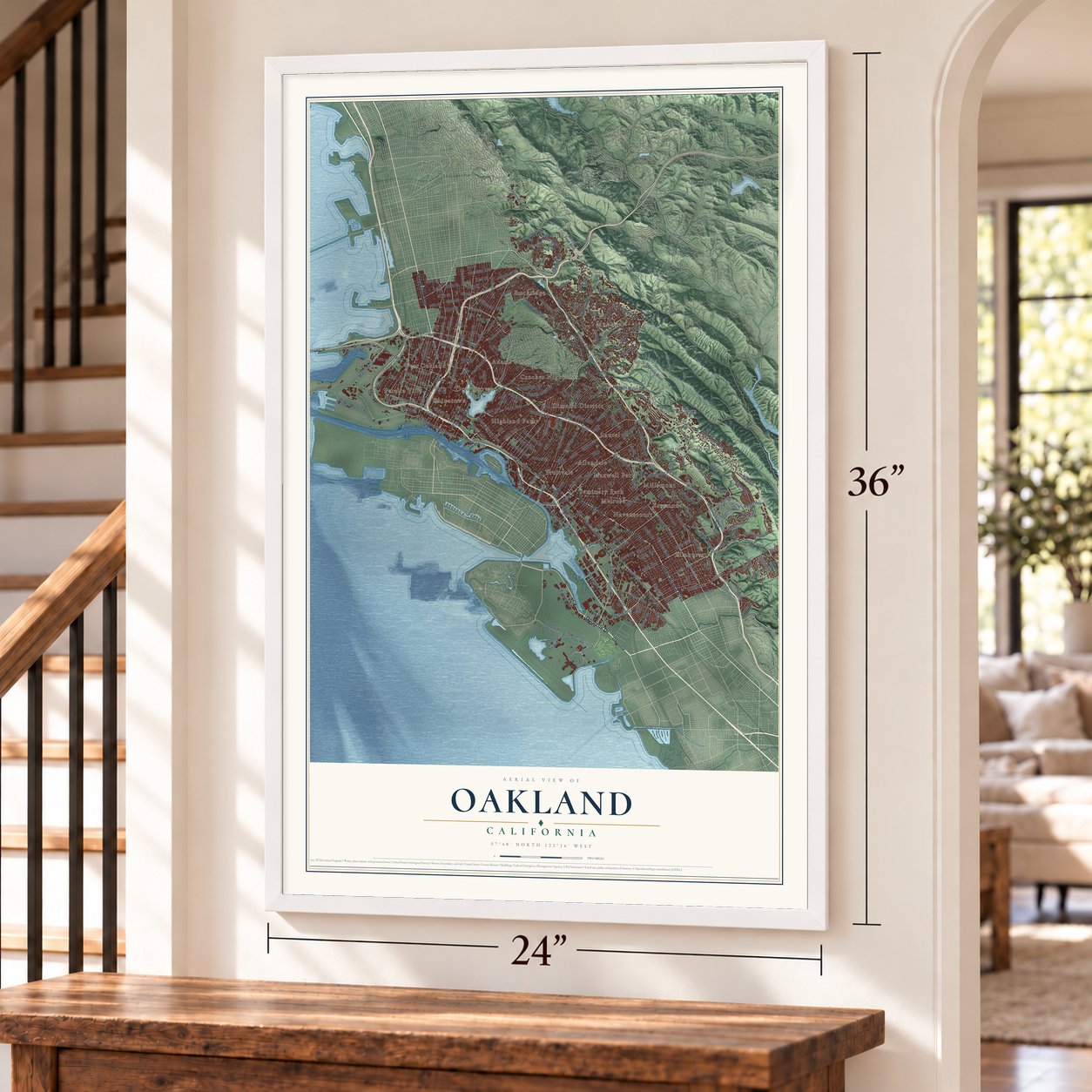
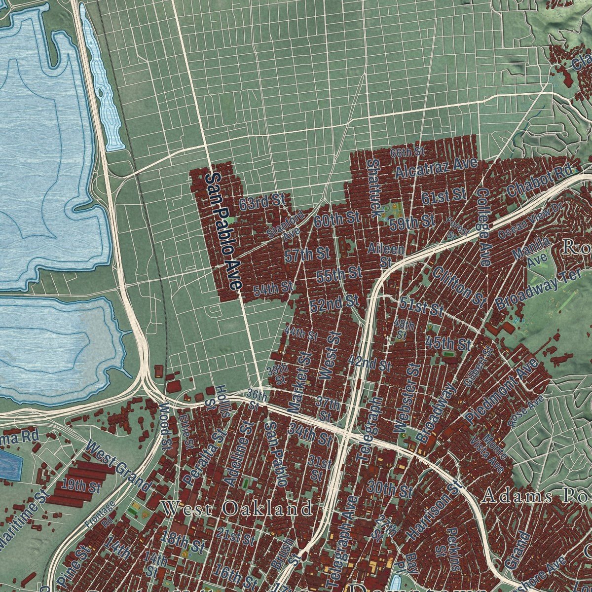
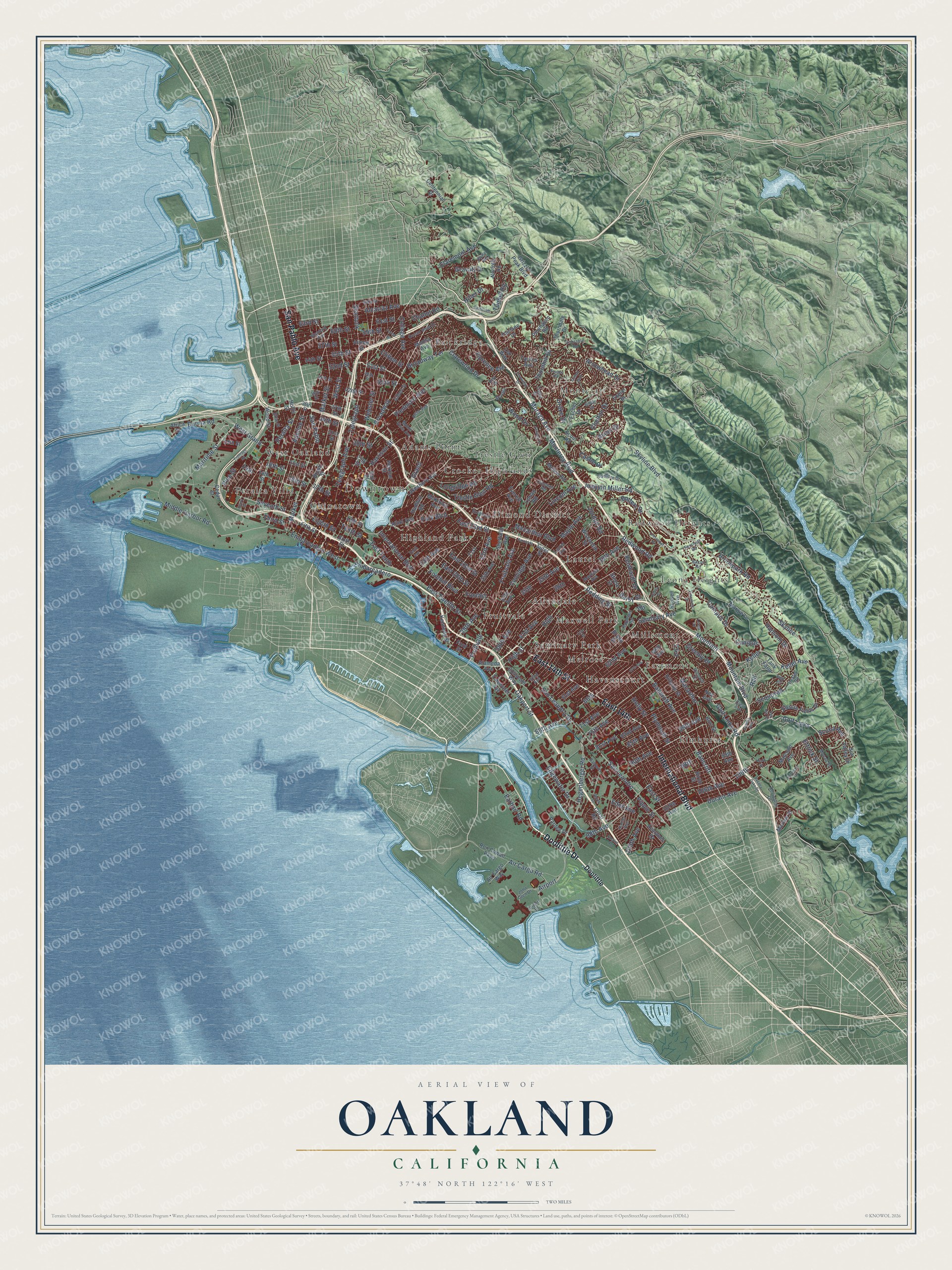
Explore Oakland, California from a whole new perspective. Created using aerial imagery and detailed geographic data, this map captures Oakland building by building, with labeled streets, familiar landmarks, and shaded topographical relief that highlights the natural contours of the landscape.
Combining modern data with the timeless character of a vintage atlas, this map is just as interesting up close as it is beautiful on the wall. Whether you grew up in Oakland, spent memorable years there, or call it home today, this unique map is a great way to celebrate a place that means something to you. Zoom in on the preview to look for your street, and then order a print to put your memories on the wall.
Three ways to hang it
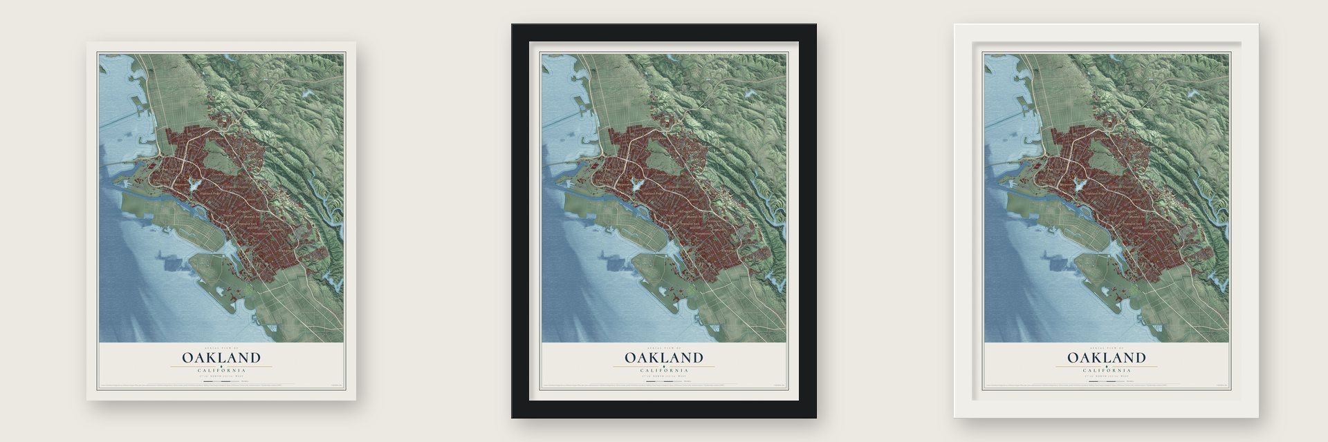
Unframed archival matte, a black wood frame or a white wood frame.
Up close
Geography Worth Displaying
This map was created using accurate cartographic data and authoritative geographic sources, including the U.S. Geological Survey and the Census Bureau. The map brings together terrain, waterways, roads, and building detail. The majority of the streets are labeled, houses are accurately depicted, and the topography is derived from government sources. Combining local data with carefully composed color and shading leads to this beautifully detailed Oakland artwork for your wall.
Rather than simply showing street outlines, we’ve included as many of the street names as we could reasonably fit on the map while keeping their names legible. Zoom in on the high resolution preview to see exactly what’s on the map. We truly set out to create a statement piece for anyone who loves Oakland. So whether it’s for you, or a gift for someone you love, we hope this map of Oakland brings back fond memories.
Read the story behind this map of Oakland, California from 2026.

Find your street
Names on the Oakland map
Every name below is printed on this map. Look for your street, your school, the park where you played, or the pond down the road.
Places and landmarks24
- Downtown
- Adams Point
- Allendale
- Chinatown
- Crocker Highlands
- Dimond District
- Eastmont
- Elmhurst
- Fruitvale
- Havenscourt
- Highland Park
- Laurel
Show all 24 places
- Leona Heights
- Maxwell Park
- Melrose
- Millsmont
- Montclair
- Peralta Villa
- Redwood Heights
- Rockridge
- Seminary Park
- Trestle Glen
- West Oakland
- Airport
Streets and roads280
- Doolittle Drive
- International Boulevard
- East 14th Street
- East 14th
- San Pablo Avenue
- Macarthur Boulevard
- Bancroft
- Claremont Avenue
- 51st Street
- Shattuck
- 52nd Street
- Fruitvale Avenue
- Bancroft Avenue
- Webster Street
- West Street
- East 20th Street
- Broadway
- Tenth Street
- 105th Avenue
- Sequoyah
- Skyline Boulevard
- Mountain Boulevard
- Foothill Boulevard
- Seventh Street
- Park Boulevard
- San Leandro Street
- Foothill
- Hegenberger Road
- East Twelfth Street
- Golf Links Road
Show all 280 streets
- Broadway Terrace
- San Leandro
- Market Street
- 98th Avenue
- 35th Avenue
- Telegraph Avenue
- Telegraph
- High Street
- Redwood Road
- Campus Drive
- Joaquin Miller Road
- 14th
- Middle Harbor Road
- Seminary Avenue
- Market
- Adeline Street
- Moraga Avenue
- Harrison Street
- Oakport Street
- 98th
- 66th Avenue
- 38th Avenue
- Macarthur
- 90th Avenue
- Golf Links
- Eighth Street
- High
- 23rd Avenue
- 85th Avenue
- Monterey Boulevard
- Coolidge Avenue
- Alcatraz Avenue
- West Grand
- College Avenue
- Keller Avenue
- Mountain
- Maritime Street
- 39th Avenue
- Embarcadero
- Peralta Street
- Earhart Road
- Thornhill Drive
- Skyline
- 17th Street
- Tunnel Road
- 62nd Avenue
- Keller
- East 23rd Street
- 61st Street
- 35th
- Grand
- 34th Street
- Holly Street
- Edes Avenue
- 18th Street
- San Pablo
- Plymouth Street
- Embarcadero West
- 81st Avenue
- 16th Street
- 63rd Street
- Trestle Glen Road
- 13th Avenue
- Third Street
- Campus
- 106th Avenue
- Ascot Drive
- Lincoln Avenue
- Edgewater Drive
- Chelton Drive
- Burma Road
- 59th Street
- 88th Avenue
- 30th Street
- Piedmont Avenue
- Chabot Road
- 55th Street
- East Street
- 75th Avenue
- 60th Street
- 73rd
- 45th Street
- Air Cargo Road
- Maple Avenue
- 57th Street
- Durant Avenue
- Castle Drive
- Butters Drive
- Hiller Drive
- Hansom Drive
- Redding Street
- 38th
- 66th
- Reinhardt Drive
- Gravatt Drive
- Longridge Road
- 71st Avenue
- 41st Avenue
- Florence Avenue
- Greenly Drive
- Clarewood Drive
- 29th Avenue
- Arrowhead Drive
- Brookpark Road
- East 33rd Street
- Jordan Road
- Clifton Street
- 106th
- Ettrick Street
- Top
- Pippin Street
- Drake Drive
- Scotia Avenue
- East Tenth
- Wood Drive
- Pine Street
- Daisy Street
- Rall
- Doolittle
- Grizzly Peak Boulevard
- 34th Avenue
- Lakeshore Avenue
- 14th Street
- Coliseum Way
- 27th Street
- Fifth Street
- 82nd Avenue
- Wood Street
- 21st Street
- Manila Avenue
- 25th Avenue
- 19th Street
- Birch Street
- Malcolm Avenue
- 13th Street
- 107th Avenue
- Air Cargo Way
- 68th Avenue
- Centennial Drive
- 42nd Street
- Brush Street
- 54th Street
- Aileen Street
- Elysian Fields Drive
- 21st
- 61st Avenue
- Hillside Street
- 99th Avenue
- Ney Avenue
- Margie Lane
- Suter Street
- Africa Street
- Pinehaven Road
- Athol Avenue
- Burr Street
- Marlow Drive
- 37th Street
- Thorndale Drive
- Ron Cowan Parkway
- Brann Street
- Sixth Street
- Everett Avenue
- Fairlane Drive
- Exeter Drive
- Wisconsin Street
- Escher Drive
- Perkins Street
- Tank Farm
- Sun Valley Drive
- Pardee Drive
- Kennedy Street
- Bay Place
- Taurus Avenue
- Lyman Road
- Melvin Road
- Alameda Avenue
- Scout Road
- 31st Street
- McKinley Avenue
- Haddon Road
- Acalanes Drive
- Coral Road
- Tidewater Avenue
- Norfolk Road
- Steele Street
- Ford Street
- Sheffield Avenue
- Russell Avenue
- Hollis Street
- Cedar Street
- Leo Way
- Stanford Avenue
- Excelsior Avenue
- Airport Drive
- Hillmont Drive
- Girvin Drive
- 44th Street
- Ocean View Drive
- Sanborn Drive
- 36th Street
- John Glen Drive
- Laurel Avenue
- 66th Street
- Maybelle Avenue
- Crest Avenue
- 52nd Avenue
- 39th Street
- Fernhoff Road
- Monte Vista Avenue
- Clemens Road
- Monan Street
- Bacon Road
- Gilbert Street
- Moraga
- Heafey Road
- Hunter Avenue
- Drury Road
- Ettie Street
- 48th Street
- Kaplolani Road
- Covington Drive
- Baldwin Street
- Rose Avenue
- Cabot Drive
- Sobrante Road
- Amy Drive
- Oak Hill Road
- Estates Drive
- Colton Boulevard
- Tenth Avenue
- Caldecott Lane
- Leona Street
- Frontage Road
- 67th Avenue
- Crestmont Drive
- Empire Road
- Cole Street
- Gouldin Road
- Kerrigan Drive
- Peralta Oaks Drive
- Forest Street
- Harold Street
- Viewcrest Drive
- Fernwood Drive
- Henry Street
- Calafia Avenue
- Leona Drive
- Sage Road
- Worth Street
- Hood Street
Names are listed as they appear on the printed map. Zoom into the product photos to find them.
About Oakland, California
Oakland is a city of 440,646 people and the county seat of Alameda County, on the east side of San Francisco Bay. For thousands of years the Huchiun, an Ohlone people, lived here, mostly around Lake Merritt and Temescal Creek. Later the Spanish crown gave Luis María Peralta the East Bay, which became his Rancho San Antonio, and the oak forest on this part of it, called Encinar, or oak grove, eventually gave the city its name.
When Peralta died in 1842, he split the rancho among his four sons, and most of Oakland went to Antonio Maria and Vicente. After California joined the United States, attorney Horace Carpentier got Vicente to sign a paper called a lease that was really a mortgage on the 19,000-acre rancho, and he took the land when Peralta refused to pay. In 1851 Carpentier, Edson Adams and Andrew Moon began laying out today's downtown. The state made Oakland a town in 1852, with 75 to 100 people, and on March 25, 1854, it became a city with Carpentier as mayor, until a scandal ended his term within a year.
“They lost everything when squatters cut down their fruit trees, killed their cattle, destroyed their buildings, and even fenced off the roads leading to the rancho.”
- Where the university beganHenry Durant opened the Contra Costa Academy in Oakland in June 1853. The school grew into the College of California, and in 1869 it became the University of California's original campus. The university elected Durant its first president in June 1870 and moved north to Berkeley in the 1870s.
- End of the line in 1869Railroads turned Oakland into a major terminal in the late 1860s and 1870s. The Central Pacific built the Oakland Long Wharf at Oakland Point in 1868, and in 1869 the city was picked as the western end of the Transcontinental Railroad. The Port of Oakland stands on the wharf's old site and is now the busiest port in Northern California.
- The Detroit of the WestGeneral Motors opened its Oakland Assembly plant in East Oakland in 1917, building Chevrolet cars and later GMC trucks until 1963, when the work moved to Fremont. By 1920 the city also made metals, engines and ships, and when Chrysler opened a new plant here in 1929, people called Oakland the "Detroit of the West." About 13,000 homes went up between 1921 and 1924 for the new factory workers.
- Airmail lands in 1920Russell Clifford Durant opened Durant Field, at the corner of East 14th Street and 82nd Avenue, in 1916. On August 9, 1920, Eddie Rickenbacker, an Army captain, and Bert Acosta, a Navy lieutenant, landed there to finish the first transcontinental airmail flight. People often called the field Oakland Airport, though today's airport was soon built four miles to the southwest.
- Ships and canneries in wartimeDuring World War II, the Moore Dry Dock Company expanded and turned out more than 100 ships. Canning came second, with Oakland's canneries worth $100 million in 1943. The biggest stood in the Fruitvale District, among them the Josiah Lusk Canning Company, the California Packing Company and the Oakland Preserving Company, where the Del Monte brand began. Tens of thousands of workers arrived from across the country, many of them from the Deep South.
Keep exploring California
Oakland is one of 1,990 California towns we've mapped. Every dot on the map is a print of its own.
The search covers every state, California first.
Near Oakland
Order 2 or more town maps and save 10%. Shown in the size and finish you picked above, so they hang as a set.
- Maxwell Park 12" x 18" / Archival Matte Print $39.99
- Clinton 12" x 18" / Archival Matte Print $39.99
- Dimond District 12" x 18" / Archival Matte Print $39.99


More maps nearby: Glenview, Alameda, Trestle Glen, Millsmont and Eastmont.
The art of mapping a place
How This Map Was Made
Real places. Remarkable detail. Discover the layers that turn geographic data into a map of home.

The view from above
Aerial imagery reveals the character of the land: woodland, open fields, and the patterns of a place.

The shape of the land
Elevation data brings hills, valleys, and subtle changes in the landscape into view.

The details of home
Roads, waterways, and building footprints come together to make the map feel unmistakably local.

Geography becomes art
Considered color, shading, and typography bring the layers together in a map made for your wall.


Process illustrated with Mendon, Massachusetts. Aerial imagery: USDA NAIP. Terrain: USGS 3D Elevation Program. Map details and finished artwork: KNOWOL.
The Details
About This Print
Choose an archival matte print, or a black or white Ayous wood frame. The archival matte print is unframed.
Select your size and finish above to see the matching product image and price.
Materials & Craftsmanship
A contemporary map with the character of a classic atlas, printed on archival matte paper. Optional frames are made from Ayous wood.
Your printed map does not include the watermark shown in the full-map preview.
Shipping & Delivery
Free shipping within the United States. Every print is made to order in the USA.
Buying a gift? Add a note in your cart and we'll include it. We never put prices in the package.
Prints ship within 2 to 3 business days. Allow 7 to 10 days total from ordering for delivery. Timing may vary during holidays or periods of high order volume.
Read our shipping policy.
Returns and damaged prints
Each print is made to order. Change-of-mind refunds are not available after production.
If your print arrives damaged, misprinted or incorrect, contact support@knowol.com within 30 days of receiving it. Include your order number, photos and a description of the issue.
Read our full refund and replacement policy. For questions about your order, email support@knowol.com.