


Search for another town



Free U.S. delivery 7 to 10 days after you order
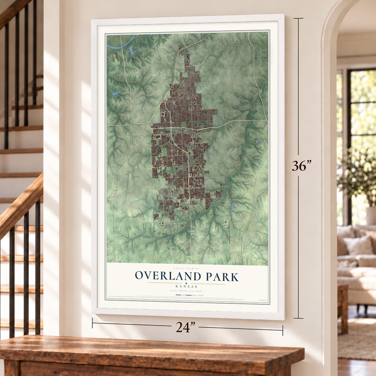
Overland Park, Kansas Map Art
Building by building, with labeled streets and shaded relief.
12" x 18" Archival Matte Print
A Map of Home. A Work of Art.
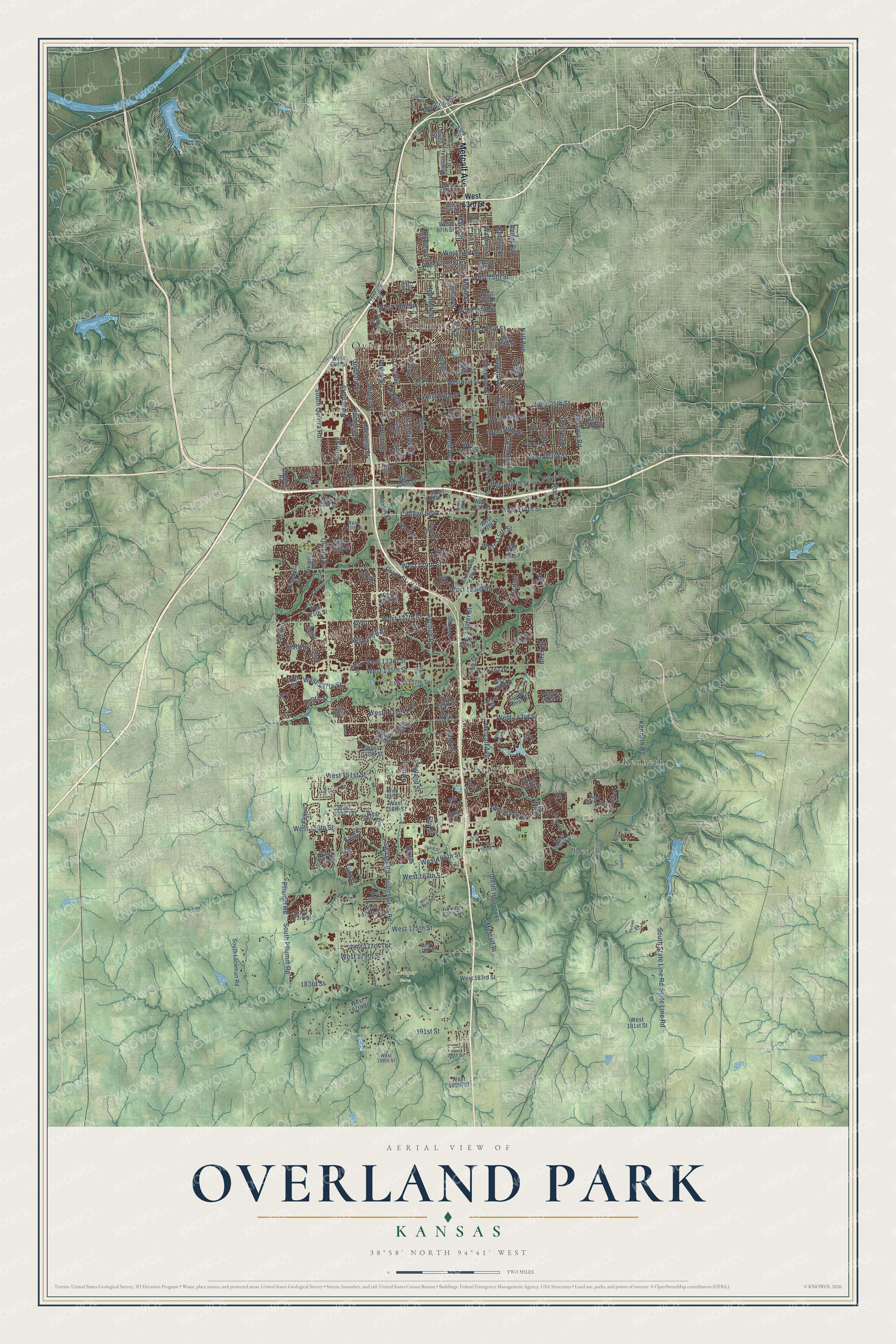
Explore Overland Park, Kansas from a whole new perspective. Created using aerial imagery and detailed geographic data, this map captures Overland Park building by building, with labeled streets, familiar landmarks, and shaded topographical relief that highlights the natural contours of the landscape.
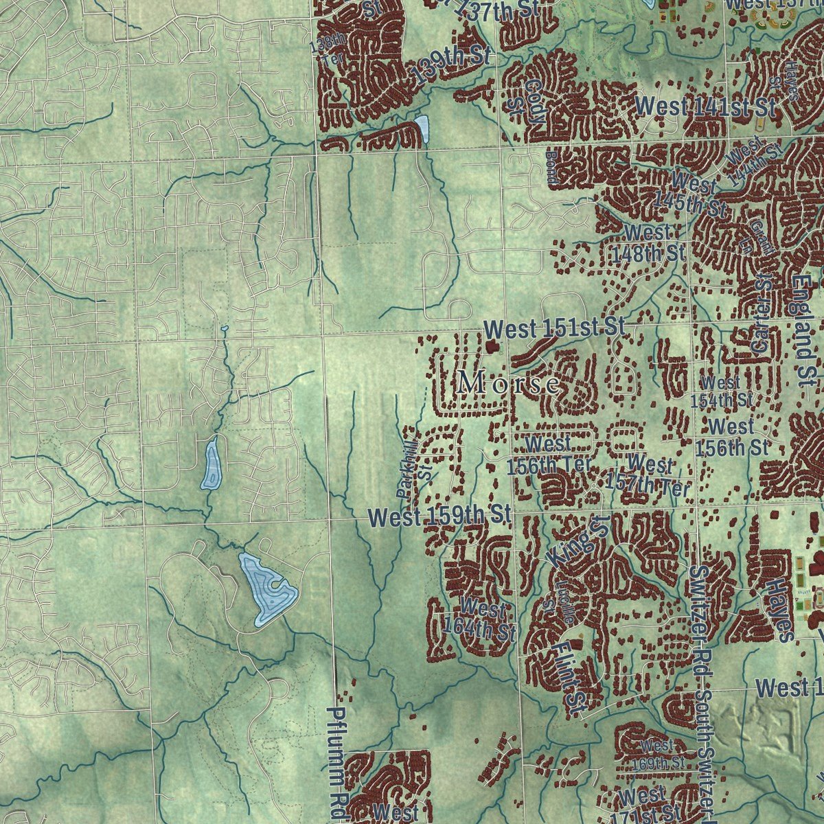
Combining modern data with the timeless character of a vintage atlas, this map is just as interesting up close as it is beautiful on the wall. Whether you grew up in Overland Park, spent memorable years there, or call it home today, this unique map is a great way to celebrate a place that means something to you. Zoom in on the preview to look for your street, and then order a print to put your memories on the wall.
Three ways to hang it
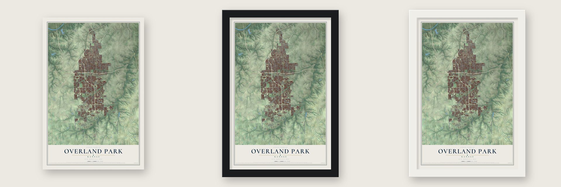
Unframed archival matte, a black wood frame or a white wood frame.
Up close
Geography Worth Displaying
This map was created using accurate cartographic data and authoritative geographic sources, including the U.S. Geological Survey and the Census Bureau. The map brings together terrain, waterways, roads, and building detail. The majority of the streets are labeled, houses are accurately depicted, and the topography is derived from government sources. Combining local data with carefully composed color and shading leads to this beautifully detailed Overland Park artwork for your wall.
Rather than simply showing street outlines, we’ve included as many of the street names as we could reasonably fit on the map while keeping their names legible. Zoom in on the high resolution preview to see exactly what’s on the map. We truly set out to create a statement piece for anyone who loves Overland Park. So whether it’s for you, or a gift for someone you love, we hope this map of Overland Park brings back fond memories.
Read the story behind this map of Overland Park, Kansas from 2026.

Find your street
Names on the Overland Park map
Every name below is printed on this map. Look for your street, your school, the park where you played, or the pond down the road.
Places and landmarks7
- Overland Park City Hall
- Kemper Farm
- Elmhurst
- Kenneth
- Morse
- Redel
- Stanley
Streets and roads222
- Metcalf Avenue
- Antioch Road
- Lowell Avenue
- College Boulevard
- West 111th Street
- Marty Street
- Grant Street
- Farley Street
- West 123rd Street
- West 129th Street
- West 75th Street
- West 137th Street
- Nieman Road
- Melrose Street
- Horton Street
- Floyd Street
- Mission Road
- Switzer Road
- Quivira Road
- Lamar Avenue
- Nall Avenue
- West 159th Street
- Pflumm Road
- South Pflumm Road
- Foster Street
- Hemlock Street
- Glenwood Street
- Hardy Street
- West 95th Street
- West 103rd Street
Show all 222 streets
- West 119th Street
- Goddard Street
- Hadley Street
- West 175th Street
- Walmer Street
- West 151st Street
- Conser Street
- West 135th Street
- West 143rd Street
- Grandview Street
- England Street
- West 133rd Street
- Flint Street
- Bond Street
- West 127th Street
- Beverly Street
- West 99th Street
- Eby Street
- West 115th Street
- 191st Street
- Wedd Street
- West 141st Street
- West 97th Street
- West 167th Street
- Mastin Street
- Roe Avenue
- West 179th Street
- Switzer Street
- King Street
- West 93rd Street
- Kenneth Road
- West 83rd Street
- South State Line Road
- State Line Road
- West 80th Street
- West 79th Street
- Birch Street
- West 165th Street
- Reeds Road
- West 71st Street
- 183rd Street
- West 107th Street
- West 72nd Terrace
- Metcalf Place
- South Quivira Road
- Delmar Street
- West 177th Terrace
- Hayes Drive
- Grant Avenue
- Merriam Drive
- 129th Street
- Haskins
- Horton
- 139th Street
- Hayes
- West 63rd Street
- West 116th Street
- West 112th Street
- West 108th Terrace
- Grant Drive
- Lowell Street
- Rosehill Street
- West 158th Street
- West 157th Terrace
- Bluejacket Street
- West 91st Street
- Newton Street
- Carter Street
- West 106th Street
- Benson Street
- Riley Street
- West 110th Street
- West 87th Street
- Oakmont Street
- West 89th Street
- West 101st Street
- Craig Street
- Barton Street
- Cody Street
- West 124th Street
- West 85th Street
- Outlook Drive
- Barkley Street
- Maple Street
- West 156th Street
- South Switzer Road
- Perry Street
- West 132nd Street
- Connell Drive
- West 98th Street
- West 109th Street
- Old US Highway 69
- West 105th Street
- West 125th Street
- Blue Valley Parkway
- West 139th Street
- Sprint Parkway
- West 148th Street
- Ash Street
- West 153rd Street
- West 156th Terrace
- West 140th Street
- West 67th Street
- West 164th Street
- Frontage Road
- West 145th Street
- West 78th Street
- West 171st Street
- West 138th Street
- West 137th Terrace
- Kobe Drive
- South Lackman Road
- West 183rd Street
- West 187th Street
- West 73rd Street
- Golden Bear Drive
- Eby Avenue
- Carter Drive
- West 191st Street
- West 173rd Street
- West 199th Street
- Briar Street
- West 94th Terrace
- West 61st Street
- 141st Street
- Noland Road
- 158th Street
- 137th Street
- 53rd Street
- Indian Creek Parkway
- West 117th Street
- Long Street
- West 96th Street
- Mackey Street
- Goodman Street
- Knox Street
- Slater Street
- West 144th Street
- West 157th Street
- West 113th Street
- West 154th Street
- Goddard Avenue
- Parkhill Street
- West 90th Terrace
- West 163rd Terrace
- Chadwick Street
- Valley View Drive
- West 172nd Terrace
- Century Street
- West 142nd Terrace
- West 64th Street
- 155th Terrace
- Ash Drive
- Century
- West 178th Street
- Grand Vw
- West 195th Street
- 134th Street
- 121st Place
- 161st Street
- West 121st Terrace
- Hayes Street
- West 100th Terrace
- Rosewood Street
- County Line Road
- West 131st Street
- Broadmoor Street
- West 147th Street
- Access Road
- West 127th Terrace
- West 163rd Street
- West 128th Street
- West 74th Street
- West 104th Street
- Lucille Street
- West 170th Terrace
- Reeds Street
- West 162nd Terrace
- Newton Drive
- Grant Lane
- West 66th Street
- West 169th Street
- West 155th Place
- Melrose Drive
- Kranker Drive
- 117th Street
- West 194th Terrace
- Bond
- 138th Terrace
- Conser Avenue
- Verona Road
- Chaney Lane
Names are listed as they appear on the printed map. Zoom into the product photos to find them.
About Overland Park, Kansas
Overland Park is a city of 197,238 people in Johnson County, and it is the second-largest city in Kansas. William B. Strang Jr. arrived in 1905 and began laying out subdivisions beside an old military road. That road grew into the city's main street, and Strang developed much of what is now downtown.
On May 20, 1960, Overland Park incorporated as a city of the first class, with 28,085 people. In 1963 it adopted a mayor-council-manager form of government. New subdivisions kept spreading across open land, and the city annexed them, so by 1990 it had 111,790 people. In the early 2000s it passed Kansas City, Kansas, and only Wichita is now larger in the state.
“Many renowned aviators made Overland Park a stop, including the Wright Brothers.”
- The fight over annexationOverland Park counted 173,250 people in 2010 and now covers 75.37 square miles, reaching across almost all of Johnson County from north to south. Its last attempt to annex land, in 2008, made the news when affected residents protested loudly. State lawmakers then changed the law, so any annexation over 40 acres now needs a majority vote of the people who live there.
- Home of Sprint until 2020The Sprint Corporation had its headquarters in Overland Park until it merged with T-Mobile in 2020, and T-Mobile is now the city's largest employer. Applebee's was based here from 1993 to 2007, and Black & Veatch and Ash Grove Cement Company still have their headquarters in the city.
- First woman police chiefDoreen Jokerst was sworn in on October 14, 2024, as the first woman to lead the Overland Park Police Department.
Keep exploring Kansas
Overland Park is one of 764 Kansas towns we've mapped. Every dot on the map is a print of its own.
The search covers every state, Kansas first.
Near Overland Park
Order 2 or more town maps and save 10%. Shown in the size and finish you picked above, so they hang as a set.
- Leawood 12" x 18" / Archival Matte Print $39.99
- Olathe 12" x 18" / Archival Matte Print $39.99
- Prairie Village 12" x 18" / Archival Matte Print $39.99


More maps nearby: Lenexa, Aubry, Stilwell, Merriam and Mission Hills.
The art of mapping a place
How This Map Was Made
Real places. Remarkable detail. Discover the layers that turn geographic data into a map of home.

The view from above
Aerial imagery reveals the character of the land: woodland, open fields, and the patterns of a place.

The shape of the land
Elevation data brings hills, valleys, and subtle changes in the landscape into view.

The details of home
Roads, waterways, and building footprints come together to make the map feel unmistakably local.

Geography becomes art
Considered color, shading, and typography bring the layers together in a map made for your wall.


Process illustrated with Mendon, Massachusetts. Aerial imagery: USDA NAIP. Terrain: USGS 3D Elevation Program. Map details and finished artwork: KNOWOL.
The Details
About This Print
Choose an archival matte print, or a black or white Ayous wood frame. The archival matte print is unframed.
Select your size and finish above to see the matching product image and price.
Materials & Craftsmanship
A contemporary map with the character of a classic atlas, printed on archival matte paper. Optional frames are made from Ayous wood.
Your printed map does not include the watermark shown in the full-map preview.
Shipping & Delivery
Free shipping within the United States. Every print is made to order in the USA.
Buying a gift? Add a note in your cart and we'll include it. We never put prices in the package.
Prints ship within 2 to 3 business days. Allow 7 to 10 days total from ordering for delivery. Timing may vary during holidays or periods of high order volume.
Read our shipping policy.
Returns and damaged prints
Each print is made to order. Change-of-mind refunds are not available after production.
If your print arrives damaged, misprinted or incorrect, contact support@knowol.com within 30 days of receiving it. Include your order number, photos and a description of the issue.
Read our full refund and replacement policy. For questions about your order, email support@knowol.com.