


Search for another town


Free U.S. delivery 7 to 10 days after you order
Pikeville, Kentucky Map Art
Building by building, with labeled streets and shaded relief.
12" x 18" Archival Matte Print
A Map of Home. A Work of Art.
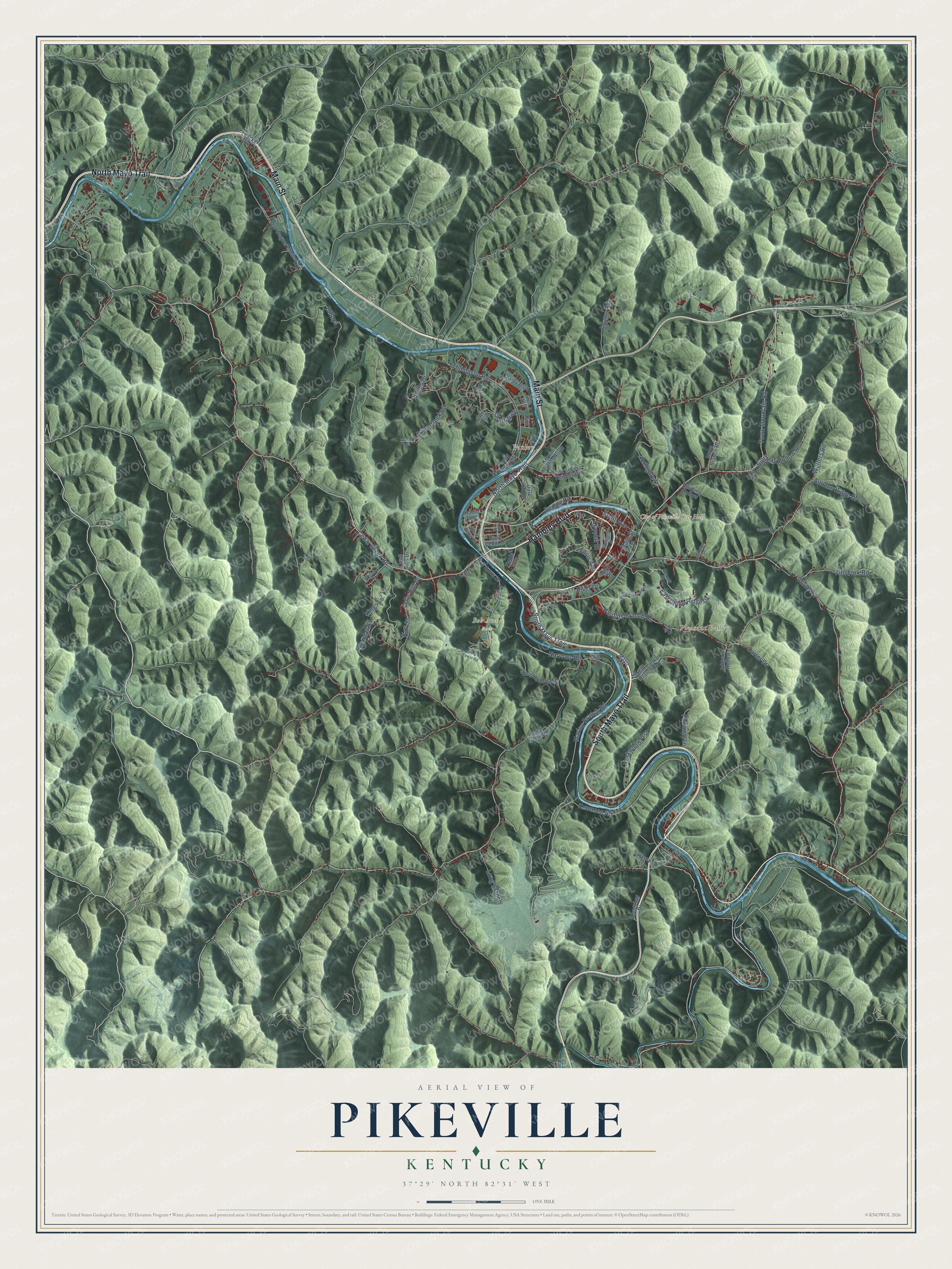
Explore Pikeville, Kentucky from a whole new perspective. Created using aerial imagery and detailed geographic data, this map captures Pikeville building by building, with labeled streets, familiar landmarks, and shaded topographical relief that highlights the natural contours of the landscape.
Combining modern data with the timeless character of a vintage atlas, this map is just as interesting up close as it is beautiful on the wall. Whether you grew up in Pikeville, spent memorable years there, or call it home today, this unique map is a great way to celebrate a place that means something to you. Zoom in on the preview to look for your street, and then order a print to put your memories on the wall.
Three ways to hang it

Unframed archival matte, a black wood frame or a white wood frame.
Up close
Geography Worth Displaying
This map was created using accurate cartographic data and authoritative geographic sources, including the U.S. Geological Survey and the Census Bureau. The map brings together terrain, waterways, roads, and building detail. The majority of the streets are labeled, houses are accurately depicted, and the topography is derived from government sources. Combining local data with carefully composed color and shading leads to this beautifully detailed Pikeville artwork for your wall.
Rather than simply showing street outlines, we’ve included as many of the street names as we could reasonably fit on the map while keeping their names legible. Zoom in on the high resolution preview to see exactly what’s on the map. We truly set out to create a statement piece for anyone who loves Pikeville. So whether it’s for you, or a gift for someone you love, we hope this map of Pikeville brings back fond memories.
Read the story behind this map of Pikeville, Kentucky from 2026.

Find your street
Names on the Pikeville map
Every name below is printed on this map. Look for your street, your school, the park where you played, or the pond down the road.
Places and landmarks4
- City of Pikeville City Hall
- Bob Amos Park
- Pleasant Valley
- Pauley
Streets and roads79
- Main Street
- North Mayo Trail
- South Mayo Trail
- Hambley Boulevard
- Julius Avenue
- East Chloe Ridge Drive
- Town Mountain Road
- Marion Branch Road
- Chloe Road
- Harolds Branch Road
- Cedar Creek Road
- Thompson Road
- Billops
- Walters Road
- Kings Lane
- Lykins Creek Road
- Fife Fork Road
- Kati Street
- Narrows Road
- Williams Hollow Road
- Yorkwood Frst
- Northgate Drive
- Poplar Street
- Autumn Ridge Drive
- Quail Walk
- Summer Street
- Long Branch
- Kewanee Road
- Billips Drive
- Foxcroft Lane
Show all 79 streets
- Scott Avenue
- Redale Road
- Adams Road
- Carter Drive
- River Drive
- Bob Amos Drive
- Dark Hollow
- Island Creek Road
- Old Wagner Station Road
- South Lanks Branch Road
- Rich Hollow Road
- Cedar Hills Drive
- East Keyser Heights Drive
- Cassidy Boulevard
- East Cedar Drive
- Vera Drive
- Keyser Heights North
- Radio Road
- Mays Branch Road
- Pound Puppy Drive
- Thacker Road
- Johnson Hollow
- Bill King Hollow
- Longview Drive
- Fields Way
- Kasey Lane
- Cecil Hills Drive
- Doe Run
- Mayo Circle
- Bank Street
- Lee Avenue
- Summit Drive
- Winston Drive
- West Cedar Drive
- Melvina Drive
- Elkins Road
- Oak Lane
- Map Drive
- Little Lane
- Keel Street
- Jay Street
- Ivy Court
- Sycamore Street
- West Chloe Ridge Drive
- West Tower Road
- Starnes Drive
- Rachel Fork
- Fidler Drive
- Claire Lane
Names are listed as they appear on the printed map. Zoom into the product photos to find them.
About Pikeville, Kentucky
Pikeville is a city of 7,754 people and the seat of Pike County, built in a narrow valley on the Levisa Fork of the Big Sandy River. On March 25, 1822, state officials chose a site called Liberty, 1.5 miles below the mouth of the Russell Fork, for the new county seat. People disliked the choice, so on December 24, 1823, officials moved the seat to land given by a farmer named Elijah Adkins.
The settlement began in 1824 as Pike, named for the county, which honored the explorer and general Zebulon Pike. It became Piketon in 1829, was incorporated under that name in 1848, and took the name Pikeville in 1850. In 1965 the National Civic League named it an All-American City.
- The Pikeville Cut-ThroughBetween 1973 and 1987, crews carved a huge gap through the ridge just west of downtown, moving nearly 18,000,000 cubic yards of soil and rock. The project sent the Levisa Fork along a new course, which ended the flooding in the old river bend and eased the traffic jams downtown. Only one earthmoving job in the Western Hemisphere has been bigger.
- Where the McCoys restPart of the Hatfield-McCoy feud played out in Pikeville. Randolph McCoy, head of the McCoy family, lies buried with his wife and daughter on a hillside above town. In 2018 Alltech of Lexington opened Dueling Barrels Brewery & Distillery downtown, naming it for the feud, and its tours bring in storytellers who recount those events.
- Hillbilly Days since 1976Local Shriners started Hillbilly Days in 1976 to raise money for the Shriners Children's Hospital. Held each April, it has grown into Kentucky's second-largest festival, with crafts, mountain music on six stages around downtown and a contest for the wildest hillbilly outfit. The festival pokes fun at the region's stereotype while honoring Appalachian heritage, and its proceeds still go to Shriners Hospitals for Children.
- Greg Maddux's rookie yearFrom 1982 to 1984 Pikeville fielded a Rookie level team in the Appalachian League, first as a Milwaukee Brewers affiliate and then with the Chicago Cubs. Greg Maddux, later elected to the Baseball Hall of Fame, spent his first professional season with the 1984 Pikeville Cubs.
- A medical school in 1997In 1997 the school then called Pikeville College, known today as the University of Pikeville, launched the Kentucky College of Osteopathic Medicine. That made it one of the smallest colleges in the nation with a medical program. In 2016 it added the Kentucky College of Optometry, the first school of its kind in Central Appalachia.
Keep exploring Kentucky
Pikeville is one of 659 Kentucky towns we've mapped. Every dot on the map is a print of its own.
The search covers every state, Kentucky first.
Near Pikeville
Order 2 or more town maps and save 10%. Shown in the size and finish you picked above, so they hang as a set.
- Coal Run Village 12" x 18" / Archival Matte Print $39.99
- Millard 12" x 18" / Archival Matte Print $39.99
- Betsy Layne 12" x 18" / Archival Matte Print $39.99


More maps nearby: Virgie, McDowell, Kimper, Dorton and Wheelwright.
The art of mapping a place
How This Map Was Made
Real places. Remarkable detail. Discover the layers that turn geographic data into a map of home.

The view from above
Aerial imagery reveals the character of the land: woodland, open fields, and the patterns of a place.

The shape of the land
Elevation data brings hills, valleys, and subtle changes in the landscape into view.

The details of home
Roads, waterways, and building footprints come together to make the map feel unmistakably local.

Geography becomes art
Considered color, shading, and typography bring the layers together in a map made for your wall.


Process illustrated with Mendon, Massachusetts. Aerial imagery: USDA NAIP. Terrain: USGS 3D Elevation Program. Map details and finished artwork: KNOWOL.
The Details
About This Print
Choose an archival matte print, or a black or white Ayous wood frame. The archival matte print is unframed.
Select your size and finish above to see the matching product image and price.
Materials & Craftsmanship
A contemporary map with the character of a classic atlas, printed on archival matte paper. Optional frames are made from Ayous wood.
Your printed map does not include the watermark shown in the full-map preview.
Shipping & Delivery
Free shipping within the United States. Every print is made to order in the USA.
Buying a gift? Add a note in your cart and we'll include it. We never put prices in the package.
Prints ship within 2 to 3 business days. Allow 7 to 10 days total from ordering for delivery. Timing may vary during holidays or periods of high order volume.
Read our shipping policy.
Returns and damaged prints
Each print is made to order. Change-of-mind refunds are not available after production.
If your print arrives damaged, misprinted or incorrect, contact support@knowol.com within 30 days of receiving it. Include your order number, photos and a description of the issue.
Read our full refund and replacement policy. For questions about your order, email support@knowol.com.