


Search for another town


Free U.S. delivery 7 to 10 days after you order
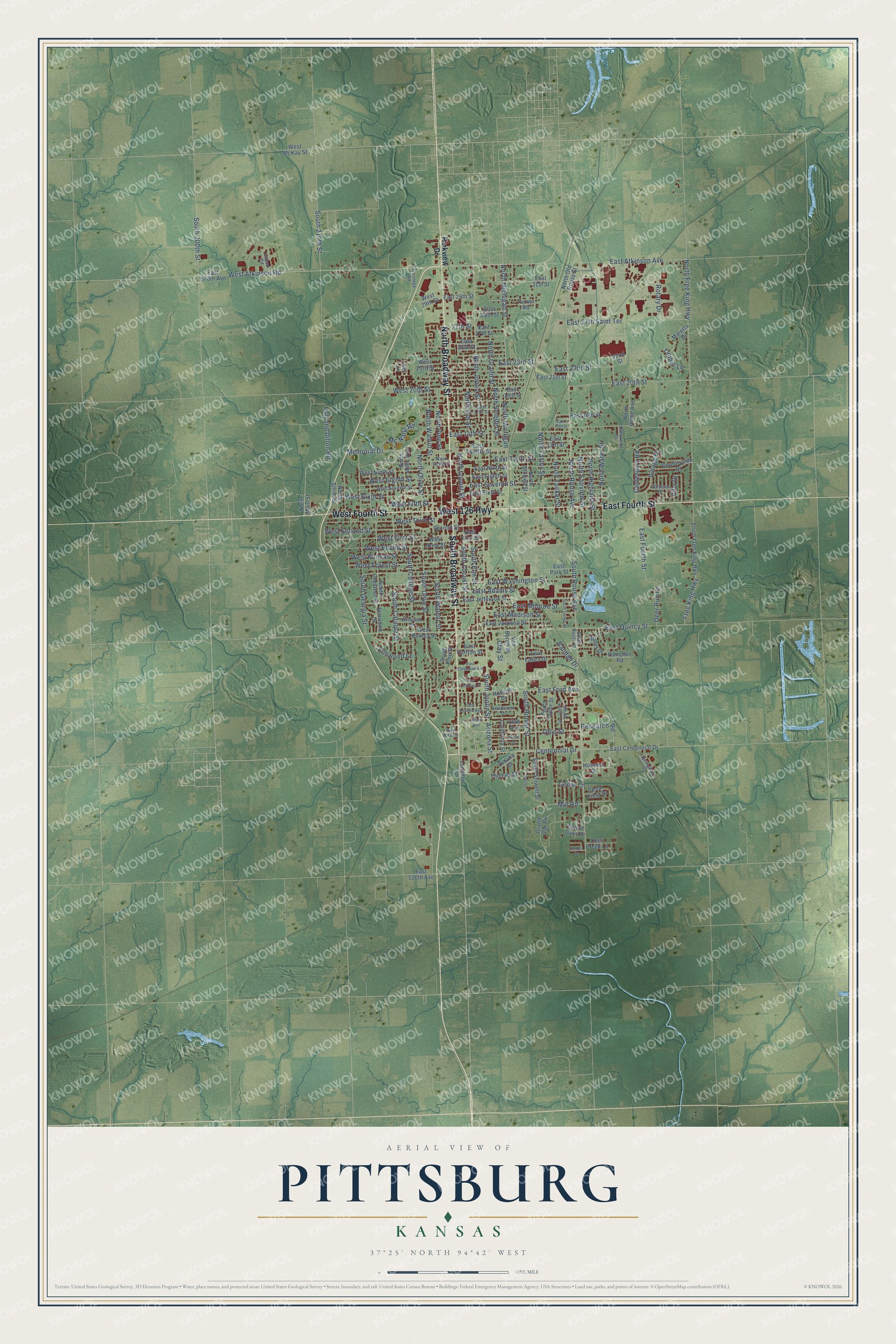
Pittsburg, Kansas Map Art
Building by building, with labeled streets and shaded relief.
12" x 18" Archival Matte Print
A Map of Home. A Work of Art.
Explore Pittsburg, Kansas from a whole new perspective. Created using aerial imagery and detailed geographic data, this map captures Pittsburg building by building, with labeled streets, familiar landmarks, and shaded topographical relief that highlights the natural contours of the landscape.
Combining modern data with the timeless character of a vintage atlas, this map is just as interesting up close as it is beautiful on the wall. Whether you grew up in Pittsburg, spent memorable years there, or call it home today, this unique map is a great way to celebrate a place that means something to you. Zoom in on the preview to look for your street, and then order a print to put your memories on the wall.
Three ways to hang it

Unframed archival matte, a black wood frame or a white wood frame.
Up close
Geography Worth Displaying
This map was created using accurate cartographic data and authoritative geographic sources, including the U.S. Geological Survey and the Census Bureau. The map brings together terrain, waterways, roads, and building detail. The majority of the streets are labeled, houses are accurately depicted, and the topography is derived from government sources. Combining local data with carefully composed color and shading leads to this beautifully detailed Pittsburg artwork for your wall.
Rather than simply showing street outlines, we’ve included as many of the street names as we could reasonably fit on the map while keeping their names legible. Zoom in on the high resolution preview to see exactly what’s on the map. We truly set out to create a statement piece for anyone who loves Pittsburg. So whether it’s for you, or a gift for someone you love, we hope this map of Pittsburg brings back fond memories.
Read the story behind this map of Pittsburg, Kansas from 2026.

Find your street
Names on the Pittsburg map
Every name below is printed on this map. Look for your street, your school, the park where you played, or the pond down the road.
Streets and roads162
- North Broadway Street
- South Broadway Street
- East Fourth Street
- West 126 Highway
- West Fourth Street
- East Atkinson Avenue
- South Joplin Street
- West Atkinson Road
- Centennial Drive
- North Rouse Avenue
- South Rouse Avenue
- West First Street
- North Joplin Street
- North Michigan Street
- North Taylor Street
- Arizona Street
- North Locust Street
- West 20th Street
- South Locust Street
- East 20th Street
- West Forest Street
- West Kansas Street
- East Madison Street
- West Fifth Street
- North Olive Street
- South Olive Street
- East Seventh Street
- South Walnut Street
- Free King Highway
- North Free King Highway
Show all 162 streets
- East Quincy Street
- East 14th Street
- North Walnut Street
- North Grand Street
- South Elm Street
- East Tenth Street
- East 22nd Street
- North Pine Street
- South 210th Street
- West Third Street
- East 23rd Street
- South 200th Street
- North Smelter Street
- South Homer Street
- East Ford Avenue
- East Monroe Street
- South College Street
- North Elm Street
- North Highland Street
- West Sixth Street
- West Euclid Street
- East Washington Street
- South Catalpa Street
- North Michigan
- East 27th Saint Terrace
- North Tucker Street
- West Second Street
- South Georgia Street
- North Water Street
- West Eighth Street
- Memorial Drive
- Ohio Street
- North Fairview Street
- Hull and Dillon Road
- East Adams Street
- Canterbury Road
- Village Drive
- Mill Road
- 27th Street
- Mc Nally Road
- Research Road
- Elmwood Lane
- Clay Street
- Deer Run Lane
- Rotary Drive
- Timber Lane
- Villa Drive
- Randall Drive
- Cedar Lane
- Parkview Drive
- East First Street
- East 31st Street
- East Centennial Drive
- West McKay Street
- Thomas Street
- West Rose Street
- 22nd Street
- South Pine Street
- North Stilwell Street
- South Stilwell Street
- East Eighth Street
- East Ninth Street
- East Sixth Street
- East Jefferson Street
- East 21st Street
- South Taylor Street
- South Free King Highway
- East 16th Street
- West Quincy Street
- West Ninth Street
- North Miles Avenue
- East Jackson Street
- Second Street
- East Park Street
- North Old Rouse Street
- Grand Oak Pk
- East 13th Street
- North Main Street
- East 19th Street
- Van Buren Street
- South Chestnut Street
- East 25th Street
- North Smith Street
- Countryside Drive
- East Twelfth Street
- East 29th Street
- East 520th Avenue
- California Street
- North Home Avenue
- Twin Lakes Drive
- Utah Avenue
- Maretta Drive
- Grand Oaks Drive
- Cedar Crest Drive
- Hampton Road
- Bitner Drive
- Deer Creek Lane
- East 28th Street
- Elmwood Drive
- West 23rd Street
- West 29th Street
- East 570th Avenue
- East 27th Street
- Omaha Street
- Turner Road
- East Carlton Street
- Langdon Lane
- Hobson Drive
- Hospital Drive
- Iris Lane
- West Seventh Street
- East 17th Street
- Fieldcrest Drive
- South Tucker Terrace
- West Tenth Street
- South Rouse Street
- Springdale Street
- Airport Road
- Winwood Drive
- Windsor Drive
- Lakewood Drive
- Frontage Road
- East 15th Street
- South Tucker Street
- Thomas
- East Cleveland Avenue
- East Hudson Avenue
- East Lindburg Street
- Union Avenue
- Norris Drive
- Amber Drive
- West Mead Street
Names are listed as they appear on the printed map. Zoom into the product photos to find them.
About Pittsburg, Kansas
Pittsburg is a city of 20,646 people in Crawford County, in southeast Kansas close to the Missouri border. It started in the fall of 1876 as a coal mining camp beside a railroad that was still under construction. That year Col. E. H. Brown laid out the town for Moffett & Sargent, and a post office opened with George Richey in charge. Because it was a mining center, the town took its name from Pittsburgh, Pennsylvania, and early maps called it New Pittsburgh.
The town was incorporated in 1879. On June 21, 1880, it became a third class city and dropped the "New," with M. M. Snow as its first mayor. It rose to the second class in 1892 and the first class in 1905. The post office became Pittsburgh in 1881, then lost its final h in 1894, when the federal Board on Geographic Names urged towns ending in "burgh" to drop the letter.
- The Cow Creek SkirmishOn October 23, 1864, the 6th Kansas Cavalry under Col. William Campbell was guarding a wagon train of refugees from Fort Smith, Arkansas, when it met the 1st Indian Brigade under Maj. Andrew Jackson Piercy near today's wastewater treatment plant. A few wagons fled, but Confederate troops caught and burned them, killing three Union soldiers and 13 civilian men. On October 30, 2011, a granite memorial to the fight was dedicated close to the Crawford County Historical Museum.
- Pittsburg & Midway CoalTwo miners from Joplin made the first commercial try at mining near Broadway Street in 1879. The Pittsburg & Midway Coal Company followed in 1885, named in part for a camp halfway between Baxter Springs and Fort Scott. It became one of the oldest coal companies in the country and kept the Pittsburg name until Chevron folded it into Chevron Mining in 2007.
- A college since 1903Pittsburg State University opened in 1903 to train teachers. It grew into a school with many programs, kept a strong focus on manual and industrial arts, and trained many of the region's teachers.
- Little Balkans DaysMany miners who settled around Pittsburg came from Southern and Eastern Europe, and early in the 20th century it was the most heavily unionized city in Kansas. The three-day Little Balkans Days festival honors that heritage every Labor Day weekend.
- The fried chicken warChicken Annie's opened in 1934, and Chicken Mary's opened across the street in 1941, starting a friendly rivalry that still goes on. Members of the two founding families married and now run a third restaurant. In 2012 Brian Williams, who began his career at KOAM-TV in Pittsburg, covered the rivalry on the Travel Channel.
Keep exploring Kansas
Pittsburg is one of 764 Kansas towns we've mapped. Every dot on the map is a print of its own.
The search covers every state, Kansas first.
Near Pittsburg
Order 2 or more town maps and save 10%. Shown in the size and finish you picked above, so they hang as a set.
- Frontenac 12" x 18" / Archival Matte Print $39.99
- Chicopee 12" x 18" / Archival Matte Print $39.99
- Yale 12" x 18" / Archival Matte Print $39.99


The art of mapping a place
How This Map Was Made
Real places. Remarkable detail. Discover the layers that turn geographic data into a map of home.

The view from above
Aerial imagery reveals the character of the land: woodland, open fields, and the patterns of a place.

The shape of the land
Elevation data brings hills, valleys, and subtle changes in the landscape into view.

The details of home
Roads, waterways, and building footprints come together to make the map feel unmistakably local.

Geography becomes art
Considered color, shading, and typography bring the layers together in a map made for your wall.


Process illustrated with Mendon, Massachusetts. Aerial imagery: USDA NAIP. Terrain: USGS 3D Elevation Program. Map details and finished artwork: KNOWOL.
The Details
About This Print
Choose an archival matte print, or a black or white Ayous wood frame. The archival matte print is unframed.
Select your size and finish above to see the matching product image and price.
Materials & Craftsmanship
A contemporary map with the character of a classic atlas, printed on archival matte paper. Optional frames are made from Ayous wood.
Your printed map does not include the watermark shown in the full-map preview.
Shipping & Delivery
Free shipping within the United States. Every print is made to order in the USA.
Buying a gift? Add a note in your cart and we'll include it. We never put prices in the package.
Prints ship within 2 to 3 business days. Allow 7 to 10 days total from ordering for delivery. Timing may vary during holidays or periods of high order volume.
Read our shipping policy.
Returns and damaged prints
Each print is made to order. Change-of-mind refunds are not available after production.
If your print arrives damaged, misprinted or incorrect, contact support@knowol.com within 30 days of receiving it. Include your order number, photos and a description of the issue.
Read our full refund and replacement policy. For questions about your order, email support@knowol.com.