


Search for another town


Free U.S. delivery 7 to 10 days after you order
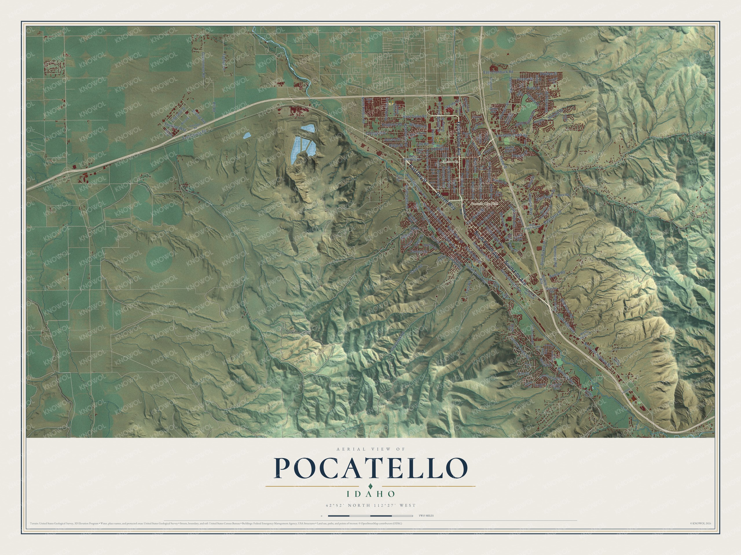
Pocatello, Idaho Map Art
Building by building, with labeled streets and shaded relief.
12" x 18" Archival Matte Print
A Map of Home. A Work of Art.
Explore Pocatello, Idaho from a whole new perspective. Created using aerial imagery and detailed geographic data, this map captures Pocatello building by building, with labeled streets, familiar landmarks, and shaded topographical relief that highlights the natural contours of the landscape.
Combining modern data with the timeless character of a vintage atlas, this map is just as interesting up close as it is beautiful on the wall. Whether you grew up in Pocatello, spent memorable years there, or call it home today, this unique map is a great way to celebrate a place that means something to you. Zoom in on the preview to look for your street, and then order a print to put your memories on the wall.
Three ways to hang it

Unframed archival matte, a black wood frame or a white wood frame.
Up close
Geography Worth Displaying
This map was created using accurate cartographic data and authoritative geographic sources, including the U.S. Geological Survey and the Census Bureau. The map brings together terrain, waterways, roads, and building detail. The majority of the streets are labeled, houses are accurately depicted, and the topography is derived from government sources. Combining local data with carefully composed color and shading leads to this beautifully detailed Pocatello artwork for your wall.
Rather than simply showing street outlines, we’ve included as many of the street names as we could reasonably fit on the map while keeping their names legible. Zoom in on the high resolution preview to see exactly what’s on the map. We truly set out to create a statement piece for anyone who loves Pocatello. So whether it’s for you, or a gift for someone you love, we hope this map of Pocatello brings back fond memories.
Read the story behind this map of Pocatello, Idaho from 2026.

Find your street
Names on the Pocatello map
Every name below is printed on this map. Look for your street, your school, the park where you played, or the pond down the road.
Places and landmarks2
- Pocatello City Hall
- Alameda
Streets and roads166
- South Fifth Avenue
- East Day Street
- Yellowstone Avenue
- South Fourth Avenue
- Garrett Way
- North Old Highway 91
- Hiline Road
- Pocatello Creek Road
- McKinley Avenue
- Hospital Way
- Hyde Avenue
- North Main Street
- East Wyeth Street
- East Terry Street
- West Quinn Road
- Jefferson Avenue
- North Arthur Avenue
- Memorial Drive
- Blandy Street
- Government Road
- North Hayes Avenue
- Ducey Street
- Bannock Highway
- City Creek Road
- South Second Avenue
- East Center Street
- South Grant Avenue
- Pole Line Road
- Satterfield Drive
- North Harrison Avenue
Show all 166 streets
- Barton Road
- East Chubbuck Road
- Johnny Creek Road
- South Main Street
- Bench Road
- Bartz Drive
- Hawthorne Road
- American Road
- East Clark Street
- Willard Avenue
- East County Road
- South Fairway Drive
- Fore Road
- Alvin Ricken Drive
- Wayne Avenue
- Pit Road
- South First Avenue
- Cedar Street
- Pershing Avenue
- Park Avenue
- Cottage Avenue
- Summit Drive
- North Philbin Road
- Highland Boulevard
- Butte Street
- Fairway Drive
- Stockman Road
- Cove Road
- Vista Drive
- Olympus Drive
- Franklin Avenue
- Jerome Street
- Canyon Drive
- North Gathe Drive
- Terminal Way
- Boeing Avenue
- Kinghorn Road
- South Eighth Avenue
- Taghee Lane
- Henderson Lane
- South 19th Avenue
- Jensen Street
- Ore Ida Court
- Richland Avenue
- Jason Avenue
- Liberator Street
- Horizon Drive
- Taft Avenue
- Wingate Drive
- Gwen Drive
- Hussey Street
- Ridge Street
- Owyhee Street
- Lott Road
- Kim Drive
- Park Lane
- South Lincoln Avenue
- Hurley Drive
- Shale Drive
- Shoshone Avenue
- West Alameda Road
- Country Club Drive
- West Eldredge Road
- Birdie Thompson Drive
- Monte Vista Drive
- Kraft Road
- Foothill Boulevard
- Swisher Road
- Ada Street
- Diane Lane
- Cahina Way
- Apex Road
- Dolostone Drive
- Skyline Drive
- Mohawk Street
- Riverside Drive
- Moreland Avenue
- Wildlife Way
- Tech Farm Road
- Ammon Street
- Lavine Drive
- West Puma Lane
- Daisy Lane
- Sunny Brook Drive
- Trevor Street
- Drake Avenue
- Patsy Drive
- Pearl Street
- Fir Street
- Smile Lane
- Cree Avenue
- Lark Lane
- Pocatello Avenue
- Mooney Avenue
- Pocatello Bench Road
- West Buckskin Road
- East Elm Street
- West Clark Street
- Avenue of the Chiefs
- Michelle Street
- Fairground Drive
- Bryan Road
- Frontage Road
- Aspen Lane
- Cheyenne Avenue
- Delphic Way
- Mustang
- Redhill Road
- Foxmore Street
- Willow Street
- Gray Avenue
- Leo Lane
- Parr Road
- Sue Road
- South Tenth Avenue
- El Rancho Boulevard
- Hildreth Drive
- East Cedar Street
- Valleyview Drive
- University Drive
- Booth Drive
- Steven Street
- Granite Drive
- Flandro Drive
- Berryman Road
- Sunset Road
- Navajo Street
- North Lower Road
- Daybreak Drive
- Hubbard Avenue
- Birch Street
- Tempe Drive
- Willow Lane
- Allen Road
- Iris Street
- Ivan Avenue
Names are listed as they appear on the printed map. Zoom into the product photos to find them.
About Pocatello, Idaho
Pocatello is a city of 56,320 people and the county seat of Bannock County, on the Portneuf River. Shoshone and Bannock people lived in this corner of Idaho for centuries, and the city carries the name of Chief Pocatello, a Northern Shoshone leader of the 19th century. In 1834 Nathaniel Wyeth of Massachusetts built Fort Hall a few miles to the northeast. When the fur trade died out, the fort became a supply stop for travelers on the Oregon Trail.
Settlers came in large numbers only after gold was found in 1860. Stage and freight lines hauled goods to the mines through the Portneuf Valley, and the Union Pacific Railroad came next, so the spot grew into a busy rail junction. Pocatello was founded in 1889. Because travelers passed through the Portneuf Gap on their way west, it became known as the Gate City, the doorway to Idaho and the Pacific Northwest.
- Idaho's largest city in 1962In 1962 the neighboring city of Alameda joined Pocatello. The 1960 census had counted 10,660 people in Alameda and 28,534 in Pocatello, so the merger put Pocatello ahead of Boise and Idaho Falls as the biggest city in the state. Chubbuck, to the north, voted against a similar merger and stayed on its own.
- From worst flag to Mountains LeftThe North American Vexillological Association judged the city flag used from 2001 to 2017 the worst in North America, and Roman Mars made it famous in a 2015 TED Talk. A new flag committee first met in April 2016, with Mars there. On July 20, 2017, the City Council chose a design nicknamed Mountains Left out of 709 entries.
- A university since 1963Idaho State University began as a branch campus of the University of Idaho and later became a state college. In 1963 it became the state's second university. Its Holt Arena opened in 1970 and was called the Minidome until 1988. Each year it hosts the Simplot Games, the largest indoor high school track meet in the nation.
- A mayor who became governorC. Ben Ross served as mayor of Pocatello and went on to become the 15th governor of Idaho.
Keep exploring Idaho
Pocatello is one of 279 Idaho towns we've mapped. Every dot on the map is a print of its own.
The search covers every state, Idaho first.
Near Pocatello
Order 2 or more town maps and save 10%. Shown in the size and finish you picked above, so they hang as a set.
- Chubbuck 12" x 18" / Archival Matte Print $39.99
- Tyhee 12" x 18" / Archival Matte Print $39.99
- Arbon Valley 12" x 18" / Archival Matte Print $39.99


More maps nearby: Fort Hall, Inkom, Aberdeen, McCammon and American Falls.
The art of mapping a place
How This Map Was Made
Real places. Remarkable detail. Discover the layers that turn geographic data into a map of home.

The view from above
Aerial imagery reveals the character of the land: woodland, open fields, and the patterns of a place.

The shape of the land
Elevation data brings hills, valleys, and subtle changes in the landscape into view.

The details of home
Roads, waterways, and building footprints come together to make the map feel unmistakably local.

Geography becomes art
Considered color, shading, and typography bring the layers together in a map made for your wall.


Process illustrated with Mendon, Massachusetts. Aerial imagery: USDA NAIP. Terrain: USGS 3D Elevation Program. Map details and finished artwork: KNOWOL.
The Details
About This Print
Choose an archival matte print, or a black or white Ayous wood frame. The archival matte print is unframed.
Select your size and finish above to see the matching product image and price.
Materials & Craftsmanship
A contemporary map with the character of a classic atlas, printed on archival matte paper. Optional frames are made from Ayous wood.
Your printed map does not include the watermark shown in the full-map preview.
Shipping & Delivery
Free shipping within the United States. Every print is made to order in the USA.
Buying a gift? Add a note in your cart and we'll include it. We never put prices in the package.
Prints ship within 2 to 3 business days. Allow 7 to 10 days total from ordering for delivery. Timing may vary during holidays or periods of high order volume.
Read our shipping policy.
Returns and damaged prints
Each print is made to order. Change-of-mind refunds are not available after production.
If your print arrives damaged, misprinted or incorrect, contact support@knowol.com within 30 days of receiving it. Include your order number, photos and a description of the issue.
Read our full refund and replacement policy. For questions about your order, email support@knowol.com.