


Search for another town


Free U.S. delivery 7 to 10 days after you order
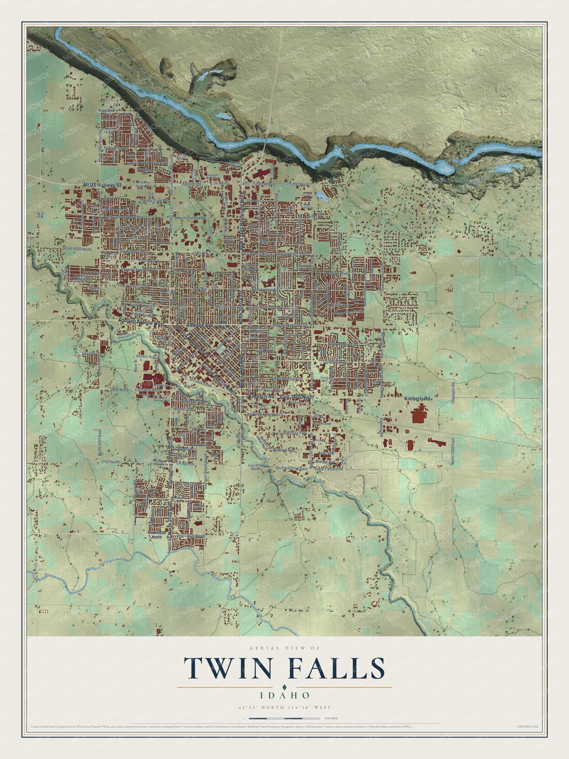
Twin Falls, Idaho Map Art
Building by building, with labeled streets and shaded relief.
12" x 18" Archival Matte Print
A Map of Home. A Work of Art.
Explore Twin Falls, Idaho from a whole new perspective. Created using aerial imagery and detailed geographic data, this map captures Twin Falls building by building, with labeled streets, familiar landmarks, and shaded topographical relief that highlights the natural contours of the landscape.
Combining modern data with the timeless character of a vintage atlas, this map is just as interesting up close as it is beautiful on the wall. Whether you grew up in Twin Falls, spent memorable years there, or call it home today, this unique map is a great way to celebrate a place that means something to you. Zoom in on the preview to look for your street, and then order a print to put your memories on the wall.
Three ways to hang it

Unframed archival matte, a black wood frame or a white wood frame.
Up close
Geography Worth Displaying
This map was created using accurate cartographic data and authoritative geographic sources, including the U.S. Geological Survey and the Census Bureau. The map brings together terrain, waterways, roads, and building detail. The majority of the streets are labeled, houses are accurately depicted, and the topography is derived from government sources. Combining local data with carefully composed color and shading leads to this beautifully detailed Twin Falls artwork for your wall.
Rather than simply showing street outlines, we’ve included as many of the street names as we could reasonably fit on the map while keeping their names legible. Zoom in on the high resolution preview to see exactly what’s on the map. We truly set out to create a statement piece for anyone who loves Twin Falls. So whether it’s for you, or a gift for someone you love, we hope this map of Twin Falls brings back fond memories.
Read the story behind this map of Twin Falls, Idaho from 2026.

Find your street
Names on the Twin Falls map
Every name below is printed on this map. Look for your street, your school, the park where you played, or the pond down the road.
Places and landmarks1
- Harmon Park
Streets and roads283
- Second Avenue South
- Blue Lakes Boulevard
- Addison Avenue
- North 3000 East
- Addison Avenue West
- North 2900 East
- Blue Lakes Boulevard North
- Kimberly Road
- East 3800 North
- Washington Street South
- Alt US Highway 93
- Second Avenue North
- Washington Street North
- Orchard Drive
- 3700 North
- 2900 East Road
- North 2800 East Road
- North 2800 East
- Minidoka Avenue
- 3800 North
- 4100 North
- Hankins Road South
- Hankins Road
- Pole Line Road East
- Poleline Road
- Canyon Rim Drive
- East 4100 North
- Blake Street North
- East 3600 North
- North 3200 East
Show all 283 streets
- Falls Avenue East
- Columbia Drive
- North 3100 Road East
- Filer Avenue West
- Sugar Factory Road
- Madison Street
- Tyler Street
- Orchard Drive East
- Eastland Drive
- East 4000 North Road
- Falls Avenue
- Filer Avenue
- Third Street West
- Tara Street
- East 4000 North
- North 3100 East
- Grandview Drive North
- Fillmore Street
- Fourth Avenue East
- Eldridge Avenue
- Locust Street North
- Filer Avenue East
- Addison Avenue East
- Elizabeth Boulevard
- Stadium Boulevard
- Ninth Avenue East
- Eastland Drive North
- Harrison Street South
- Park View Drive
- North College Road West
- Falls Avenue West
- Mountain View Drive
- Madrona Street North
- Caswell Avenue West
- Champlin Road
- Julie Lane
- North 3300 East
- Harrison Street
- North College Road
- Wendell Street
- Elm Street North
- Monroe Street
- Robbins Avenue
- Quincy Street
- Whispering Pine Drive
- Cheney Drive West
- Heyburn Avenue
- Shoup Avenue
- Locust Street
- Highland Avenue East
- Cheney Drive
- Federation Road
- Park Avenue
- Carriage Lane
- Trotter Drive
- Bitterroot Drive
- Meadowview Lane
- Buckingham Drive
- Ridgeway Drive
- Morningside Drive
- Heyburn Avenue East
- Meadowview Lane North
- Alturas Drive
- Jackson Street
- Longbow Drive
- Canyon Crest Drive West
- Buchanan Street
- Polk Street
- Ash Street
- Adams Street
- Galena Drive
- Highland Avenue
- Grandview Drive
- Elm Street
- Field Stream Way
- Shoshone Street East
- Silver Creek Way
- Clinton Drive
- Osterloh Avenue
- Maurice Street
- Sarah Avenue
- Beryl Avenue
- Diamond Avenue
- Floral Avenue
- Maple Avenue
- Atlantic Street
- Valencia Street
- Idaho Street East
- El Camino Avenue
- Rose Street
- Warren Avenue
- Martin Street
- Victory Avenue
- Frontier Road
- Wright Avenue
- Aspenwood Drive
- Grange Lane
- Canyon Street
- Hailee Avenue
- Del Mar Drive
- Sommer Street
- Noble Street
- Dierkes Road
- Sunshine Drive
- Oak Street
- Kenyon Road
- Starfire Street
- Valley Street
- Airport Road
- Spruce Street
- Cindy Drive
- Grant Avenue
- Earl Drive
- Dover Lane
- Mae Drive
- Deere Street
- 3900 North Road
- Pole Line Road West
- Diekes Street West
- North 3000 East Road
- Hankins Road North
- Clover Avenue
- Marjorie Street
- East 3700 North
- Third Avenue East
- Sunrise Boulevard North
- Sparks Street North
- Fillmore Avenue North
- Canyon Crest Drive
- Carriage Lane North
- Locust Street South
- Candleridge Drive
- Eleventh Avenue East
- Shoup Avenue West
- Crestview Drive
- Eighth Avenue East
- Wirsching Avenue West
- Pierce Street
- Jefferson Street
- Canyon Trail Way
- Heyburn Avenue West
- Second Avenue East
- Taylor Street
- Golden Pheasant Drive
- North Pointe Drive
- Welch Lane
- Fourth Avenue North
- Pheasant Road
- Morning Sun Drive
- East 4200 North
- Caswell Avenue
- Poplar Avenue
- Sunrise Boulevard
- Lois Street
- Blick Lane
- Buck Lane
- Parkway Drive
- Dubois Avenue
- North Fork Road
- Wiseman Avenue
- Butler Street
- Canyon Springs Road
- Arrow Wood Court
- Villa Road
- Plain View Drive
- Lynwood Boulevard
- Lawrence Avenue
- Pioneer Path
- Oleary Way
- Tendoy Street
- Bosero Way
- Sidney Street
- Madrin Street
- Garnet Street
- Delong Avenue
- Canyon Falls Drive
- Market Avenue
- Kanner Lane
- Arrowhead Path
- Briarcliff Drive
- Meadows Drive
- Fiesta Way
- Holly Drive
- Vista Drive
- Cherokee Lane
- Alder Drive
- Jeremy Lane
- Dorian Drive
- Kodiak Drive
- Feather Avenue
- Baker Street
- Sun Way
- Gimlet Drive
- Park Drive
- Butte Drive
- Lindy Lane
- Beta Street
- Rusty Lane
- All Street
- Lisa Court
- Orchard Drive West
- Madrona Street
- Bridgeview Boulevard
- Borah Avenue
- Walnut Street
- Shoup Avenue East
- Joshua Way
- Birchton Loop
- Diamond Avenue West
- Northern Sky Drive
- Terra Avenue
- Green Acres Drive
- Hometowne Road
- Wilmore Avenue
- Granada Drive
- Bolton Street
- Maxwell Avenue
- Caribel Street
- Aztec Drive
- North Temple Drive
- Castle Drive
- Rancho Vista Drive
- Leeann Drive
- Fourth Avenue
- Village Park Avenue
- River Vista Place
- Gem Avenue
- Billar Street
- Detters Road
- Robbi Way
- Bell Street
- Piller Street
- Seventh Avenue East
- Sunray Loop
- Sixth Avenue East
- Hansen Street East
- Blake Street South
- Van Buren Street
- Gardner Avenue
- Parkwood Drive
- Larkspur Drive
- Twin Parks Drive
- Sherry Lane
- Bracken Street South
- Eastgate Drive
- Lawndale Drive
- Linden Avenue
- Quail Street
- Cedar Block Drive
- Wall Street
- Concordia Way
- Harrisin Street
- Harold Street
Names are listed as they appear on the printed map. Zoom into the product photos to find them.
About Twin Falls, Idaho
Twin Falls is a city of 51,807 people and the seat of Twin Falls County, on a plain above the south rim of the Snake River Canyon. A few farms worked the canyon floor by 1890, but the dry land above could not be watered. In 1900 I. B. Perrine started the Twin Falls Land and Water Company to build canals. After a survey of 244,025 acres, it won its water rights that October and set aside lots for Twin Falls, Kimberly, Buhl, Filer, Hansen and Murtaugh.
Most investors quit in 1902, leaving only Stanley Milner of Salt Lake City. Perrine then raised private money from Milner and others under the Carey Act of 1894 and built Milner Dam near Caldron Linn, finished in 1905. The first townsite drawing, in July 1903, went poorly, but a second one in October 1904 sold well, and the lot money helped pay for the canals. Architect Emmanuel Louis Masqueray planned the town. It became a village on April 12, 1905, and the county seat in 1907.
“These falls are so named because the channel of the river is divided by a huge rock into two streams, each of which plunges over a precipice 197 feet in height.”
- Robert Stuart's route eastIn 1812 and 1813 Robert Stuart led a party overland from Astoria to St. Louis, crossing the land around Twin Falls on the way. His path became the basis of the Oregon Trail, and Robert Stuart Middle School is named for him. The first lasting settlement nearby came later, a stage stop set up at Rock Creek in 1864.
- Shareholders took the canalsFarm output in south-central Idaho climbed once Milner Dam was built. In 1909 the private Land and Water Company became the Twin Falls Canal Company, owned by its shareholders. The city grew into a processing center for farm crops, above all beans and sugar beets. The Twin Falls Canal Company Building is on the National Register.
- Evel Knievel's 1974 jumpIn September 1974 Evel Knievel tried to leap the Snake River Canyon on a rocket cycle while millions watched on closed-circuit television. High winds and a parachute that opened too soon ended the attempt short of the far side. The foundation of his launch ramp still sits on private land on the south rim, less than 2 miles west of Shoshone Falls.
Keep exploring Idaho
Twin Falls is one of 279 Idaho towns we've mapped. Every dot on the map is a print of its own.
The search covers every state, Idaho first.
Near Twin Falls
Order 2 or more town maps and save 10%. Shown in the size and finish you picked above, so they hang as a set.
- Kimberly 12" x 18" / Archival Matte Print $39.99
- Filer 12" x 18" / Archival Matte Print $39.99
- Hansen 12" x 18" / Archival Matte Print $39.99


More maps nearby: Jerome, Eden, Buhl, Hollister and Murtaugh.
The art of mapping a place
How This Map Was Made
Real places. Remarkable detail. Discover the layers that turn geographic data into a map of home.

The view from above
Aerial imagery reveals the character of the land: woodland, open fields, and the patterns of a place.

The shape of the land
Elevation data brings hills, valleys, and subtle changes in the landscape into view.

The details of home
Roads, waterways, and building footprints come together to make the map feel unmistakably local.

Geography becomes art
Considered color, shading, and typography bring the layers together in a map made for your wall.


Process illustrated with Mendon, Massachusetts. Aerial imagery: USDA NAIP. Terrain: USGS 3D Elevation Program. Map details and finished artwork: KNOWOL.
The Details
About This Print
Choose an archival matte print, or a black or white Ayous wood frame. The archival matte print is unframed.
Select your size and finish above to see the matching product image and price.
Materials & Craftsmanship
A contemporary map with the character of a classic atlas, printed on archival matte paper. Optional frames are made from Ayous wood.
Your printed map does not include the watermark shown in the full-map preview.
Shipping & Delivery
Free shipping within the United States. Every print is made to order in the USA.
Buying a gift? Add a note in your cart and we'll include it. We never put prices in the package.
Prints ship within 2 to 3 business days. Allow 7 to 10 days total from ordering for delivery. Timing may vary during holidays or periods of high order volume.
Read our shipping policy.
Returns and damaged prints
Each print is made to order. Change-of-mind refunds are not available after production.
If your print arrives damaged, misprinted or incorrect, contact support@knowol.com within 30 days of receiving it. Include your order number, photos and a description of the issue.
Read our full refund and replacement policy. For questions about your order, email support@knowol.com.