


Search for another town


Free U.S. delivery 7 to 10 days after you order
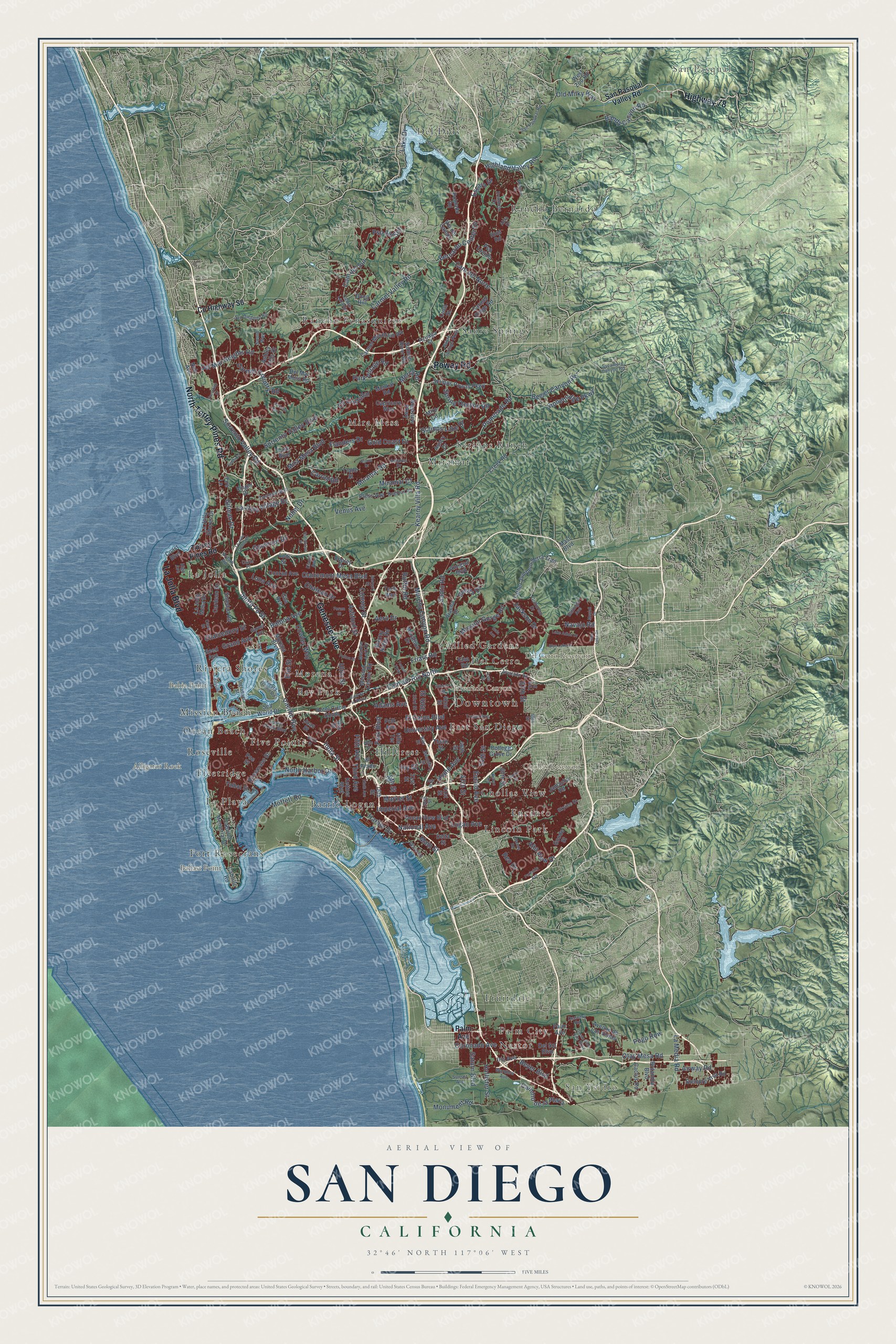
San Diego, California Map Art
Building by building, with labeled streets and shaded relief.
12" x 18" Archival Matte Print
A Map of Home. A Work of Art.
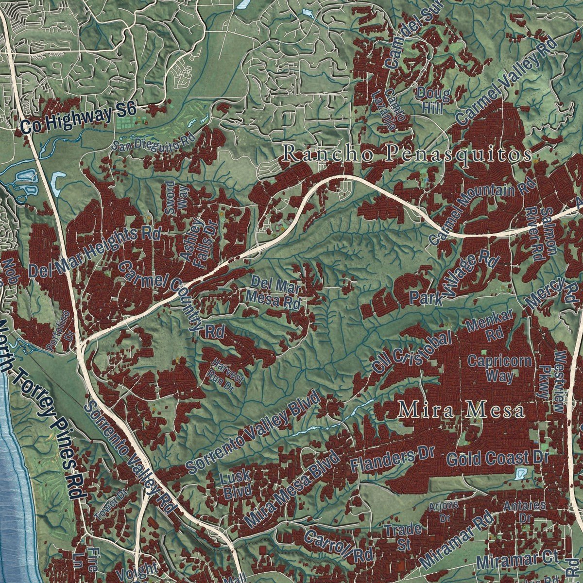
Explore San Diego, California from a whole new perspective. Created using aerial imagery and detailed geographic data, this map captures San Diego building by building, with labeled streets, familiar landmarks, and shaded topographical relief that highlights the natural contours of the landscape.
Combining modern data with the timeless character of a vintage atlas, this map is just as interesting up close as it is beautiful on the wall. Whether you grew up in San Diego, spent memorable years there, or call it home today, this unique map is a great way to celebrate a place that means something to you. Zoom in on the preview to look for your street, and then order a print to put your memories on the wall.
Three ways to hang it

Unframed archival matte, a black wood frame or a white wood frame.
Up close
Geography Worth Displaying
This map was created using accurate cartographic data and authoritative geographic sources, including the U.S. Geological Survey and the Census Bureau. The map brings together terrain, waterways, roads, and building detail. The majority of the streets are labeled, houses are accurately depicted, and the topography is derived from government sources. Combining local data with carefully composed color and shading leads to this beautifully detailed San Diego artwork for your wall.
Rather than simply showing street outlines, we’ve included as many of the street names as we could reasonably fit on the map while keeping their names legible. Zoom in on the high resolution preview to see exactly what’s on the map. We truly set out to create a statement piece for anyone who loves San Diego. So whether it’s for you, or a gift for someone you love, we hope this map of San Diego brings back fond memories.
Read the story behind this map of San Diego, California from 2026.

Find your street
Names on the San Diego map
Every name below is printed on this map. Look for your street, your school, the park where you played, or the pond down the road.
Places and landmarks38
- Downtown
- San Pasqual
- San Ysidro
- Alligator Rock
- Alvarado Canyon
- Bahia Point
- Ballast Point
- Chollas Reservoir
- Del Cerro Reservoir
- Allied Gardens
- Barrio Logan
- Bay Park
Show all 38 places
- Chollas View
- Del Cerro
- Del Dios
- East San Diego
- Encanto
- Five Points
- Fleetridge
- Fort Rosecrans
- Fruitdale
- Hillcrest
- La Jolla
- La Playa
- Lincoln Park
- Mira Mesa
- Miramar
- Mission Beach
- Morena
- Nestor
- Ocean Beach
- Palm City
- Rancho Bernardo
- Rancho Penasquitos
- Riviera Shores
- Roseville
- Sabre Springs
- Scripps Ranch
Streets and roads244
- Genesee Avenue
- North Torrey Pines Road
- La Jolla Boulevard
- Highway 78
- Poway Road
- Otay Mesa Road
- Carmel Valley Road
- Pomerado Road
- Clairemont Mesa Boulevard
- Kearny Villa Road
- Spring Canyon Road
- Friars Road
- Imperial Avenue
- Cam del Sur
- University Avenue
- Balboa Avenue
- El Cajon Boulevard
- Pacific Highway
- Mira Mesa Boulevard
- Mission Gorge Road
- 54th Street
- Market Street
- Miramar Road
- Adams Avenue
- Del Mar Heights Road
- Euclid Avenue
- Jackson Drive
- North Harbor Drive
- Airway Road
- Logan Avenue
Show all 244 streets
- Park Boulevard
- Stonebridge Parkway
- Navajo Road
- Sorrento Valley Road
- Bandy Canyon Road
- Cam del Rio North
- Moffett Road
- Monument Road
- Coronado Avenue
- Murphy Canyon Road
- Beyer Boulevard
- Flanders Drive
- La Media Road
- Santo Road
- Bernardo Center Drive
- Fifth Avenue
- Third Avenue
- Hollister Street
- 47th Street
- Main Street
- Harbor Drive
- National Avenue
- Sorrento Valley Boulevard
- Lake Drive
- Nobel Drive
- Governor Drive
- Carmel Country Road
- Grand Avenue
- Beeler Canyon Road
- Aero Drive
- Ruffin Road
- Saturn Boulevard
- Gilman Drive
- Park Village Road
- Highland Valley Road
- La Jolla Village Drive
- Cll Cristobal
- 35th Street
- Cam del Norte
- Miramar Court
- India Street
- Camino de la Plaza
- Gold Coast Drive
- Convoy Street
- Santa Fe Street
- Ulric Street
- Cowley Way
- Scripps Lake Drive
- Chalcedony Street
- Carroll Road
- Pso del Sur
- Alta View Drive
- Old Milky Way
- Home Avenue
- Venus Avenue
- Pogo Row
- Reo Drive
- Chateau Drive
- Mercy Road
- Escala Drive
- 26th Street
- Ashford Street
- Luna Avenue
- Erie Street
- Rueda Drive
- 67th Street
- Ivy Street
- San Pasqual Valley Road
- County Highway S6
- Torrey Pines Road
- Palm Avenue
- Carmel Mountain Road
- Morena Boulevard
- Rosecrans Street
- Siempre Viva Road
- Polk Avenue
- Thorn Street
- Ocean View Boulevard
- Scripps Poway Parkway
- Creek Road
- Father Junipero Serra Trail
- Kettner Boulevard
- Del Sol Boulevard
- Cabrillo Memorial Drive
- 60th Street
- 42nd Street
- Conrad Avenue
- La Jolla Shores Drive
- 31st Street
- Sea World Drive
- Antigua Boulevard
- Mission Center Road
- Pso Lucido
- 46th Street
- Westview Parkway
- Del Mar Mesa Road
- College Grove Drive
- 41st Street
- Lusk Boulevard
- Reed Avenue
- Jamacha Road
- Cabrillo Road
- 16th Street
- Cardeno Drive
- Salmon River Road
- Voight Drive
- Doug Hill
- Capricorn Way
- La Jolla Mesa Drive
- Poblado Road
- Murray Ridge Road
- Pless Avenue
- Hotel Circle South
- Britannia Boulevard
- Cactus Road
- Soledad Road
- Coast Boulevard
- Carmel Ridge Road
- Marathon Drive
- Menkar Road
- Avenue de Las Vistas
- Via del Campo
- Iris Avenue
- Ashley Falls Drive
- Copley Drive
- Talbot Street
- Ibis Street
- Viacha Drive
- Delta Street
- Goode Street
- Aviary Drive
- Trade Street
- Azuaga Street
- Rios Road
- Juan Street
- West Zoo Road
- Cuca Street
- Poe Street
- Tech Way
- Gila Avenue
- El Prado
- Miro Circle
- Lodi Street
- Elsa Road
- Mast Boulevard
- Fire Lane
- Villa Terrace
- Nob Avenue
- Fiesta Island Road
- 33rd Street
- San Dieguito Road
- 69th Street
- Skyline Drive
- Ingraham Street
- Boundary Street
- Sabre Springs Parkway
- Garnet Avenue
- Antares Drive
- Eastgate Mall
- Sycamore Canyon Road
- 36th Street
- Golfcrest Drive
- Dennery Road
- Sunset Avenue
- Sports Arena Boulevard
- Ardath Road
- San Pasqual Road
- Cass Street
- Alvarado Road
- Trojan Avenue
- Regulus Road
- Camto Lazanja
- Diane Avenue
- Ballinger Avenue
- Meadow Lark Drive
- Frondoso Drive
- Ward Road
- Nile Street
- Wardlow Avenue
- Sword Way
- 70th Street
- Abra Drive
- Curie Place
- High Avenue
- Mission Road
- Upas Street
- 55th Street
- Radio Drive
- Cam de la Reina
- Ash Street
- Bayside Lane
- Ocean View Hills Parkway
- Blue Lake Drive
- Kurtz Street
- Portofino Drive
- Parkside Avenue
- Mercury Street
- Ninth Avenue
- Lake Adlon Drive
- Fulton Street
- Tower Drive
- Fenton Parkway
- Kelton Road
- Gullstrand Street
- Arjons Drive
- La Jolla Colony Drive
- Aceituno Street
- East Lake Drive
- Harvest Run Drive
- Munda Road
- Hilldale Road
- Mewall Drive
- Forum Street
- Gala Avenue
Names are listed as they appear on the printed map. Zoom into the product photos to find them.
About San Diego, California
San Diego is a city of 1,386,932 people and the seat of San Diego County, on the Pacific coast beside the Mexican border. The Kumeyaay village of Kosa'aay, home to thirty to forty families, stood here when Juan Rodríguez Cabrillo claimed the bay for Spain in 1542 and called it San Miguel. Sebastián Vizcaíno surveyed the harbor in November 1602 and renamed it for Saint Didacus of Alcalá, known in Spanish as San Diego de Alcalá.
Gaspar de Portolá founded the Presidio of San Diego in May 1769 on a hill above the San Diego River. That July, Franciscans under Junípero Serra founded Mission San Diego de Alcalá, and together they became the first place Europeans settled in today's California. The town passed to Mexico in 1821 and to the United States under the Treaty of Guadalupe Hidalgo in 1848. In 1850 it was incorporated as a city and made the county seat.
“This lighthouse, built in 1854, was one of the first eight lighthouses on the Pacific Coast.”
- A revolt in 1775In 1775 the Kumeyaay rose up against the mission, and it moved six miles up the San Diego River. It grew anyway: by 1797 more than 1,400 converts lived in and around it, the largest native population in Alta California. It anchored the south end of El Camino Real, and the Presidio and the Mission are both National Historic Landmarks.
- The siege of 1846When war with Mexico began in 1846, Americans took San Diego, but after a revolt in Los Angeles the garrison left without firing a shot in early October. Mexican partisans held the town until the Americans retook it on October 24, then kept them blockaded for months. The Battle of San Pasqual, fought in a valley now inside the city, brought the Americans their worst losses of the campaign, and Alta California surrendered on January 13, 1847.
- A city without a charterJoshua H. Bean, the last alcalde, became the first mayor in 1850, but within two years the city was bankrupt. The state legislature took away its charter and put a board of trustees in charge, and San Diego did not get a charter back until 1889. The charter in use today dates from 1931.
- Mail across Texas in 30 daysBetween 1857 and 1860 the San Antonio-San Diego Mail Line carried passengers and letters overland, with San Diego as the end of the line in the west. It was the first stage and mail service to tie California to the eastern states by land. Leaving Texas, its coaches crossed New Mexico Territory and reached the coast in under 30 days.
- Old Town and New TownThe first town sat at the foot of Presidio Hill, miles from deep water. In 1850 William Heath Davis tried a bayside "New San Diego," but for decades it held little more than a pier, an Army depot and a few houses. In the late 1860s Alonzo Horton promoted his own "New Town" on the bay, businesses moved there for the shipping, and it became downtown San Diego. The railroad reached the city in 1878.
Keep exploring California
San Diego is one of 1,990 California towns we've mapped. Every dot on the map is a print of its own.
The search covers every state, California first.
Near San Diego
Order 2 or more town maps and save 10%. Shown in the size and finish you picked above, so they hang as a set.
- Kearny Mesa 12" x 18" / Archival Matte Print $39.99
- Serra Mesa 12" x 18" / Archival Matte Print $39.99
- Grantville 12" x 18" / Archival Matte Print $39.99


More maps nearby: Tierrasanta, Birdland, Allied Gardens, Navajo and Mission Valley.
The art of mapping a place
How This Map Was Made
Real places. Remarkable detail. Discover the layers that turn geographic data into a map of home.

The view from above
Aerial imagery reveals the character of the land: woodland, open fields, and the patterns of a place.

The shape of the land
Elevation data brings hills, valleys, and subtle changes in the landscape into view.

The details of home
Roads, waterways, and building footprints come together to make the map feel unmistakably local.

Geography becomes art
Considered color, shading, and typography bring the layers together in a map made for your wall.


Process illustrated with Mendon, Massachusetts. Aerial imagery: USDA NAIP. Terrain: USGS 3D Elevation Program. Map details and finished artwork: KNOWOL.
The Details
About This Print
Choose an archival matte print, or a black or white Ayous wood frame. The archival matte print is unframed.
Select your size and finish above to see the matching product image and price.
Materials & Craftsmanship
A contemporary map with the character of a classic atlas, printed on archival matte paper. Optional frames are made from Ayous wood.
Your printed map does not include the watermark shown in the full-map preview.
Shipping & Delivery
Free shipping within the United States. Every print is made to order in the USA.
Buying a gift? Add a note in your cart and we'll include it. We never put prices in the package.
Prints ship within 2 to 3 business days. Allow 7 to 10 days total from ordering for delivery. Timing may vary during holidays or periods of high order volume.
Read our shipping policy.
Returns and damaged prints
Each print is made to order. Change-of-mind refunds are not available after production.
If your print arrives damaged, misprinted or incorrect, contact support@knowol.com within 30 days of receiving it. Include your order number, photos and a description of the issue.
Read our full refund and replacement policy. For questions about your order, email support@knowol.com.