
Search for another town


Free U.S. delivery 7 to 10 days after you order
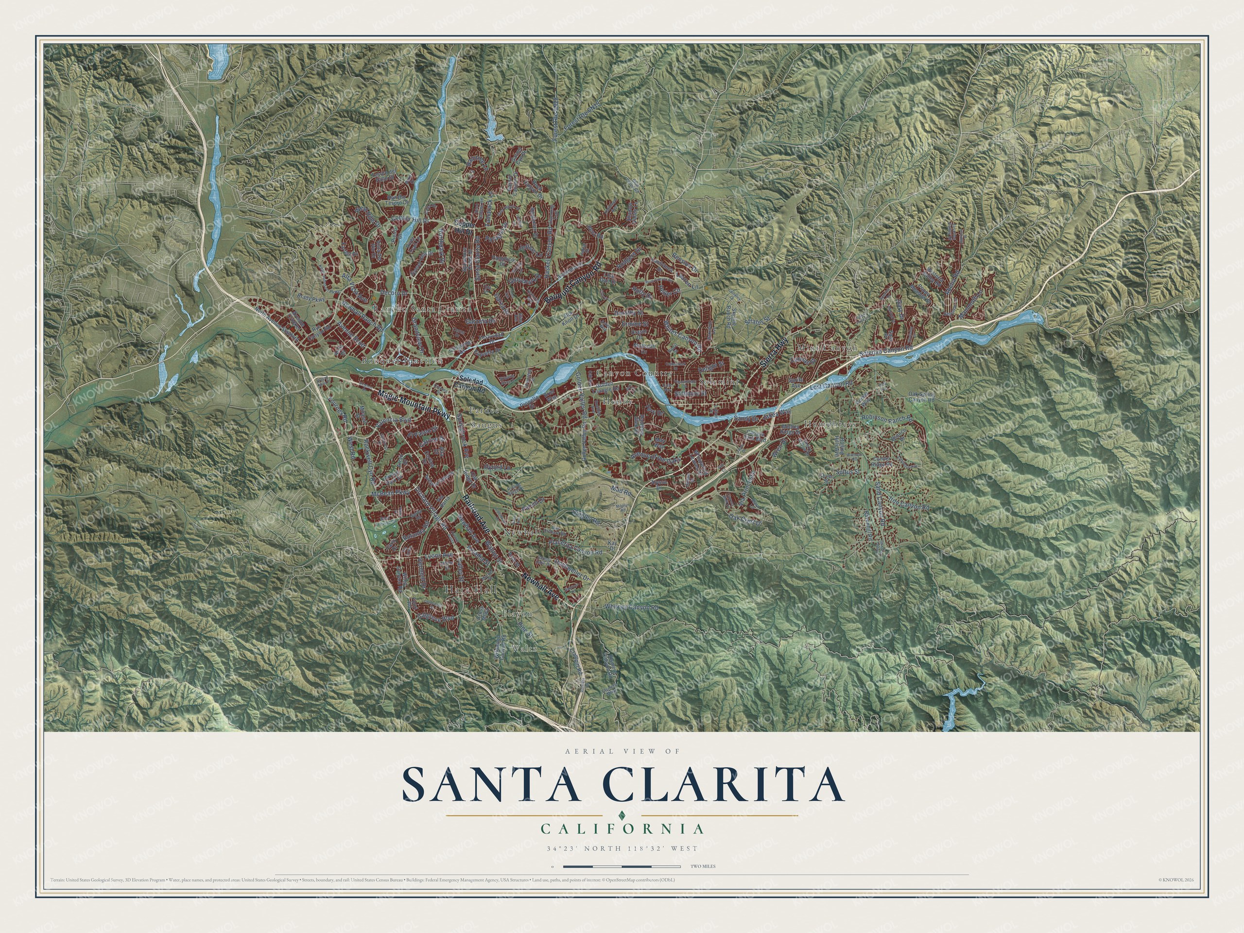
Santa Clarita, California Map Art
Building by building, with labeled streets and shaded relief.
12" x 18" Archival Matte Print
A Map of Home. A Work of Art.
Explore Santa Clarita, California from a whole new perspective. Created using aerial imagery and detailed geographic data, this map captures Santa Clarita building by building, with labeled streets, familiar landmarks, and shaded topographical relief that highlights the natural contours of the landscape.
Combining modern data with the timeless character of a vintage atlas, this map is just as interesting up close as it is beautiful on the wall. Whether you grew up in Santa Clarita, spent memorable years there, or call it home today, this unique map is a great way to celebrate a place that means something to you. Zoom in on the preview to look for your street, and then order a print to put your memories on the wall.
Three ways to hang it

Unframed archival matte, a black wood frame or a white wood frame.
Up close
Geography Worth Displaying
This map was created using accurate cartographic data and authoritative geographic sources, including the U.S. Geological Survey and the Census Bureau. The map brings together terrain, waterways, roads, and building detail. The majority of the streets are labeled, houses are accurately depicted, and the topography is derived from government sources. Combining local data with carefully composed color and shading leads to this beautifully detailed Santa Clarita artwork for your wall.
Rather than simply showing street outlines, we’ve included as many of the street names as we could reasonably fit on the map while keeping their names legible. Zoom in on the high resolution preview to see exactly what’s on the map. We truly set out to create a statement piece for anyone who loves Santa Clarita. So whether it’s for you, or a gift for someone you love, we hope this map of Santa Clarita brings back fond memories.
Read the story behind this map of Santa Clarita, California from 2026.

Find your street
Names on the Santa Clarita map
Every name below is printed on this map. Look for your street, your school, the park where you played, or the pond down the road.
Places and landmarks13
- Hart Hall
- Waltz
- Bouquet Junction
- Canyon Country
- Elayon
- Honby
- Humphreys
- Mint Canyon
- Newhall
- Pardee
- Rancho Santa Clarita
- Saugus
Show all 13 places
- Solemint
Streets and roads213
- Magic Mountain Parkway
- Newhall Avenue
- Sierra Highway
- Bouquet Canyon Road
- Railroad Avenue
- McBean Parkway
- Lyons Avenue
- Orchard Village Road
- Tourney Road
- Northpark Drive
- Copper Hill Drive
- Carrizo Drive
- Valley Street
- Golden Valley Road
- Avenue Scott
- Calgrove Boulevard
- West Road
- Rockwell Cyn Road
- Decoro Drive
- Delight Street
- Robinson Ranch Road
- Soledad Canyon Road
- Newhall Ranch Road
- Sand Canyon Road
- Via Princessa
- Placerita Canyon Road
- Lost Canyon Road
- Whites Canyon Road
- Valencia Boulevard
- Pine Street
Show all 213 streets
- Haskell Canyon Road
- Abelia Road
- Quigley Road
- Grandview Drive
- Avenue of the Oaks
- Stratus Street
- Ermine Street
- Walnut Street
- Santa Clarita Road
- West Hills Drive
- Jakes Way
- Oak Crest Drive
- Tamarack Lane
- Mammoth Lane
- Whitney Canyon Road
- Alta Vista Avenue
- Springbrook Avenue
- Garza Drive
- Iron Canyon Road
- Dockweiler Drive
- Bension Drive
- Paragon Drive
- Rodgers Drive
- Raintree Lane
- Parvin Drive
- Stillmore Street
- Grovepark Drive
- Wren Drive
- El Paseo Drive
- Rotunda Road
- Garzota Drive
- Dorothy Street
- Canvas Street
- Sultus Street
- Jeffers Lane
- Vermont Drive
- Heller Circle
- Arcadia Street
- Oxford Lane
- Lauren Lane
- Sandy Drive
- Mad Road
- Terri Drive
- Holly Drive
- Gary Drive
- Arroyo Park Drive
- Arryo Drive
- Wiley Canyon Road
- Sam Place
- Oak Spring Canyon Road
- Rainbow Glen Drive
- Alaminos Drive
- Poppy Meadow Street
- Golden Triangle Road
- Rye Canyon Road
- Elsmere Canyon Road
- Clampitt Road
- Rolling Hills Avenue
- Tesoro del Valle Drive
- Wildwood Canyon Road
- Skyline Ranch Road
- Sycamore Creek Drive
- Pamplico Drive
- Rock Canyon Drive
- Gollen Valley Road
- North Avenue Stanford
- Medley Ridge Drive
- Vista del Rio Drive
- Agajanian Drive
- Sunset Hills Drive
- Garnet Canyon Drive
- Alta Knoll Drive
- Anza Drive
- Fourl Road
- Avenue Velarte
- Canyon Park Boulevard
- Brady Parkway
- Wisteria Valley Road
- Shadow Valley Lane
- Cheyenne Drive
- Festividad Drive
- Condor Ridge Road
- Arch Street
- Rancho Tesoro Drive
- Whispering Leaves Drive
- River Trail Lane
- Diver Street
- May Way
- Ravenhill Road
- Propello Drive
- Farrier Drive
- Lanfranca Drive
- Avenue Crocker
- Espuella Drive
- Northcliff Drive
- Oak Ridge Drive
- Comet Way
- Cross Mtwy
- Via Barra
- Lisa Gail Drive
- Mirasol Street
- Kay Drive
- Garnet Cyn Drive
- Bronco Drive
- Cortina Drive
- Sarita Avenue
- Cariz Drive
- Benz Road
- Pietro Drive
- Drasin Drive
- Alyssa Drive
- Brier Way
- Alta Drive
- Calex Drive
- Seco Canyon Road
- Bakerton Avenue
- Elsmere Mtwy
- Market Street
- Ruether Avenue
- Oak Orchard Road
- Nadal Street
- Kelly Johnson Parkway
- Begonias Lane
- Cherry Willow Drive
- Jasmine Valley Drive
- Blue Cloud Road
- Kathleen Avenue
- Rolling Ridge Drive
- Township Street
- West Trevino Drive
- Silverking Trail
- Abdale Street
- Deputy Jake Drive
- Sarda Road
- Cinema Drive
- Kristin Lane
- Oak Avenue
- Cerca Drive
- Tula Drive
- Luther Drive
- Incline Lane
- Oaklar Drive
- Cherry Street
- Alara Lane
- Aster Way
- Duke Drive
- Elias Avenue
- Flo Lane
- Plum Canyon Road
- Avignon Drive
- Saddleback Drive
- Mikelyn Road
- Cedarcreek Street
- Marilyn Drive
- Goldcrest Drive
- Gold Canyon Drive
- Pleasantdale Street
- Aden Avenue
- Fambrough Street
- Warmuth Road
- Centurion Way
- Fir Court
- Refinery Road
- Gladiolus Drive
- Alderbrook Drive
- Jason Drive
- Skipping Stone Drive
- Cypress Bluff Drive
- Oakriver Lane
- Spencer Drive
- Happy Trails Road
- Sunrose Place
- Cheryl Lane
- Onlee Avenue
- Vista Point Lane
- Avenue Balita
- Cumulus Court
- Wayne Mills Place
- Calla Way
- Via Artina
- Velan Drive
- Holt Avenue
- Pad Court
Names are listed as they appear on the printed map. Zoom into the product photos to find them.
About Santa Clarita, California
Santa Clarita is a city of 228,673 people in Los Angeles County, on the Santa Clara River. Spanish explorers named the river for Saint Clare of Assisi. The valley later took the Spanish diminutive, Santa Clarita, to set it apart from Santa Clara in Northern California. Henry Mayo Newhall bought the Rancho San Francisco in 1875 for $2 an acre. He sold the Southern Pacific the land where it built the town of Newhall. In 1879 he moved the town south, and the first townsite became Saugus, named for his hometown in Massachusetts.
After Newhall died, his heirs formed the Newhall Land and Farming Company in 1883. The company guided the growth of the communities across the valley. The name Santa Clarita first went on a housing tract, Rancho Santa Clarita in Saugus, in 1947. In December 1987 Canyon Country, Newhall, Saugus and Valencia came together as the city of Santa Clarita. Many residents still name their own community when asked where they're from.
- Gold in 1842In 1842 Francisco Lopez found gold in Placerita Canyon. It was the first documented gold find in California, and Governor Alvarado issued a mining claim for it. The Oak of the Golden Dream still marks the spot. Its name lives on in Golden Oak Road, Golden Oak Ranch and several local schools.
- The West's first paying oil wellCharles Alexander Mentry, a French immigrant, founded Mentryville on September 26, 1876. Its Pico Number 4 well was the first in the western states to turn a steady profit, and it kept pumping until 1990. Its oil went to the Pioneer Oil Refinery in Newhall, the state's first refinery that worked. The refinery joined the National Register in 2020.
- The St. Francis Dam, 1928The St. Francis Dam failed just before midnight on March 12, 1928. A wave up to 140 feet high rushed down San Francisquito Canyon and the Santa Clara River, and five hours later it reached the Pacific near Ventura. The flood killed 411 people. Buildings in Newhall served as makeshift morgues, and William Mulholland resigned as head of the Los Angeles water bureau.
- Cowboy stars at homeStudios from Los Angeles began filming here soon after the turn of the century, and the actors who worked here included Tom Mix, a young John Wayne, William S. Hart and Harry Carey. Hart and Carey both settled in the valley, and their estates are now county parks. The local high school district, created in 1945, was renamed for Hart the next year.
- Saugus Cafe since 1886The Saugus Cafe opened in 1886 near what is now Railroad Avenue and Magic Mountain Parkway. No other restaurant in Los Angeles County has stayed open longer.
Keep exploring California
Santa Clarita is one of 1,990 California towns we've mapped. Every dot on the map is a print of its own.
The search covers every state, California first.
Near Santa Clarita
Order 2 or more town maps and save 10%. Shown in the size and finish you picked above, so they hang as a set.
- Stevenson Ranch 12" x 18" / Archival Matte Print $39.99
- Valencia 12" x 18" / Archival Matte Print $39.99
- Pico 12" x 18" / Archival Matte Print $39.99


More maps nearby: Sylmar, Castaic, Porter Ranch, San Fernando and Val Verde.
The art of mapping a place
How This Map Was Made
Real places. Remarkable detail. Discover the layers that turn geographic data into a map of home.

The view from above
Aerial imagery reveals the character of the land: woodland, open fields, and the patterns of a place.

The shape of the land
Elevation data brings hills, valleys, and subtle changes in the landscape into view.

The details of home
Roads, waterways, and building footprints come together to make the map feel unmistakably local.

Geography becomes art
Considered color, shading, and typography bring the layers together in a map made for your wall.


Process illustrated with Mendon, Massachusetts. Aerial imagery: USDA NAIP. Terrain: USGS 3D Elevation Program. Map details and finished artwork: KNOWOL.
The Details
About This Print
Choose an archival matte print, or a black or white Ayous wood frame. The archival matte print is unframed.
Select your size and finish above to see the matching product image and price.
Materials & Craftsmanship
A contemporary map with the character of a classic atlas, printed on archival matte paper. Optional frames are made from Ayous wood.
Your printed map does not include the watermark shown in the full-map preview.
Shipping & Delivery
Free shipping within the United States. Every print is made to order in the USA.
Buying a gift? Add a note in your cart and we'll include it. We never put prices in the package.
Prints ship within 2 to 3 business days. Allow 7 to 10 days total from ordering for delivery. Timing may vary during holidays or periods of high order volume.
Read our shipping policy.
Returns and damaged prints
Each print is made to order. Change-of-mind refunds are not available after production.
If your print arrives damaged, misprinted or incorrect, contact support@knowol.com within 30 days of receiving it. Include your order number, photos and a description of the issue.
Read our full refund and replacement policy. For questions about your order, email support@knowol.com.