


Search for another town



Free U.S. delivery 7 to 10 days after you order
Thomasville, North Carolina Map Art
Building by building, with labeled streets and shaded relief.
12" x 18" Archival Matte Print
A Map of Home. A Work of Art.
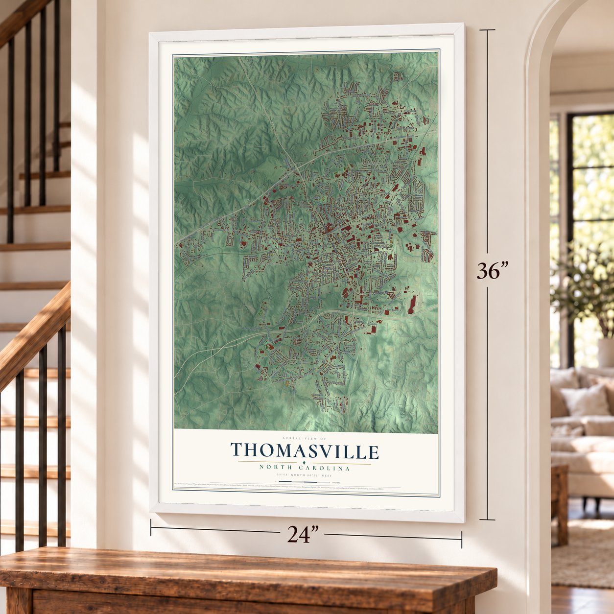
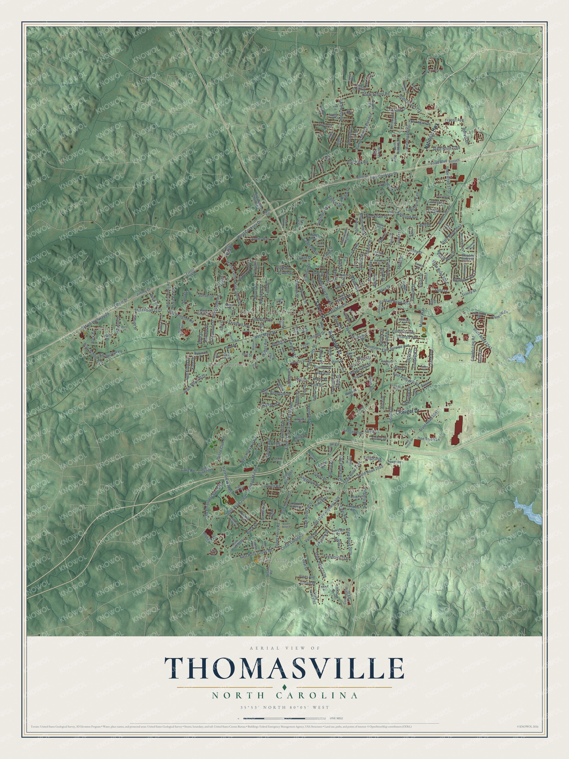
Explore Thomasville, North Carolina from a whole new perspective. Created using aerial imagery and detailed geographic data, this map captures Thomasville building by building, with labeled streets, familiar landmarks, and shaded topographical relief that highlights the natural contours of the landscape.
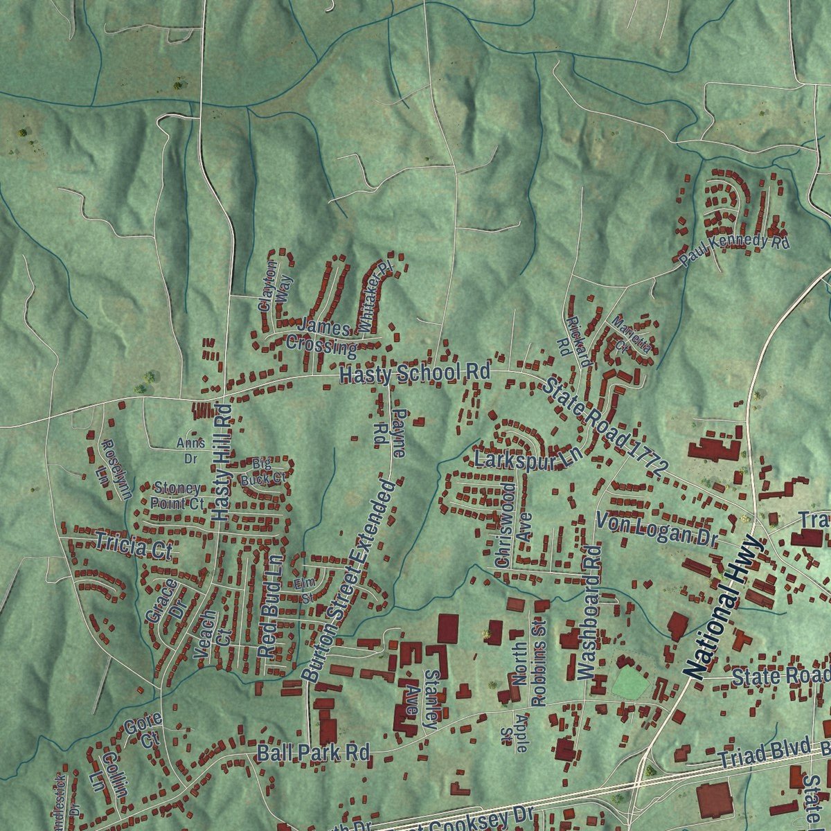
Combining modern data with the timeless character of a vintage atlas, this map is just as interesting up close as it is beautiful on the wall. Whether you grew up in Thomasville, spent memorable years there, or call it home today, this unique map is a great way to celebrate a place that means something to you. Zoom in on the preview to look for your street, and then order a print to put your memories on the wall.
Three ways to hang it
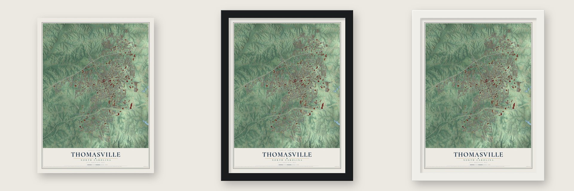
Unframed archival matte, a black wood frame or a white wood frame.
Up close
Geography Worth Displaying
This map was created using accurate cartographic data and authoritative geographic sources, including the U.S. Geological Survey and the Census Bureau. The map brings together terrain, waterways, roads, and building detail. The majority of the streets are labeled, houses are accurately depicted, and the topography is derived from government sources. Combining local data with carefully composed color and shading leads to this beautifully detailed Thomasville artwork for your wall.
Rather than simply showing street outlines, we’ve included as many of the street names as we could reasonably fit on the map while keeping their names legible. Zoom in on the high resolution preview to see exactly what’s on the map. We truly set out to create a statement piece for anyone who loves Thomasville. So whether it’s for you, or a gift for someone you love, we hope this map of Thomasville brings back fond memories.
Read the story behind this map of Thomasville, North Carolina from 2026.

Find your street
Names on the Thomasville map
Every name below is printed on this map. Look for your street, your school, the park where you played, or the pond down the road.
Places and landmarks6
- Thomasville City Hall
- Glen Anna
- Fair Grove
- Erwin Heights
- Pilot
- Johnsontown
Streets and roads328
- National Highway
- Salem Street
- Cloniger Drive
- Randolph Street
- Liberty Drive
- West Holly Hill Road
- Cedar Lodge Road
- Old State Highway 109
- State Road 2184
- East Main Street
- State Road 2054
- Trinity Street
- Fisher Ferry Road
- Fisher Ferry Street Extended
- Pineywood Road
- Turner Street
- Unity Street
- West Cooksey Drive
- State Road 2060
- West Main Street
- Lexington Avenue
- State Road 1769
- State Road 2051
- Martin Luther King Junior Drive
- County Line Road
- Blair Street
- State Road 2053
- Old US Highway 29
- Fisher Ferry Street
- Kendall Mill Road
Show all 328 streets
- Julian Avenue
- State Road 2085
- State Road 2055
- Concord Street
- Ray Street
- Brookdale Drive
- State Road 2032
- Litwin Drive
- Maple Avenue
- Jimmy Drive
- Colonial Drive
- Ball Park Road
- Hasty School Road
- State Road 1772
- Lake Road
- Albertson Road
- East Sunrise Avenue
- Lakeview Drive
- Culbreth Avenue
- State Road 2123
- East Holly Hill Road
- Carolina Avenue
- Fairgrove Road
- Memorial Park Drive
- Mendenhall Street
- State Road 2136
- Hasty Hill Road
- Ferndale Drive
- Cox Avenue
- Burton Street Extended
- State Road 2061
- State Road 2071
- Fleer Road
- State Road 2074
- Barnwell Street
- Duke Street
- Doak Street
- Washboard Road
- East Holly Grove Road
- Council Street
- Hinkle Street
- Old Emanuel Church Road
- Davidson Street
- Overbrook Drive
- Black Road
- Koontz Avenue
- Jarrett Road
- Huntsford Terrace
- Virginia Avenue
- Moore Street
- Leach Avenue
- James Avenue
- Forest Drive
- Meadow Lark Lane
- Church Street
- Hedrick Drive
- Cedar Drive
- Lowery Drive
- Old Lexington Road
- Griffith Street
- Carmalt Street
- State Road 1770
- East Cooksey Drive
- State Road 1547
- Cannon Street
- Taylor Street
- Valley Drive
- Arthur Drive
- Georgia Avenue
- Valley Road
- Pilot School Road
- Kathland Avenue
- Goforth Drive
- Spring Street
- Bell Drive
- Triad Boulevard
- Lake Drive East
- Lakeview Circle
- Long Street
- Harmon Drive
- Pine Street
- Evergreen Trail
- Sam Kinley Drive
- Mason Way
- White Street
- Polk Street
- Biggs Avenue
- Stadium Drive
- Police Club Road
- Alice Drive
- Carter Drive
- Tremont Street
- Longview Drive
- Field Street
- Oaklawn Drive
- Smith Street
- Conrad Street
- Von Logan Drive
- State Road 2815
- Broad Street
- South Street
- Rosedale Drive
- Ford Street
- Don Truell Lane
- Vivian Street
- Larkspur Lane
- Sunset Drive
- Pineywood Street
- Lambeth Street
- Transit Avenue
- Howard Street
- Reid Street
- Sunset Court
- Royal Oaks Street
- Lodge Drive
- Kern Street
- Moon Street
- Hill Street
- Fremont Drive
- Sedgehill Drive
- Red Bud Lane
- Fleer Avenue
- Kate Drive
- Laura Lane
- Tricia Court
- Cable Street
- Brown Street
- Willow Drive
- June Street
- Center Street
- Trotter Street
- Beck Road
- Donvic Drive
- Braxton Lane
- High Street
- School Street
- Aycock Street
- Todd Court
- Smith Drive
- Fife Street
- Lynn Drive
- Hyde Street
- Idol Street
- West Green Street
- Piney Wood Road
- Mount Calvary Road
- Hillcrest Circle
- State Road 2183
- State Road 2087
- Payne Road
- East Guilford Street
- Crestview Drive
- State Road 2086
- State Road 2084
- State Road 2073
- Pine Woods Church Road
- Winston Street
- Meadow Wood Drive
- Lambeth Drive
- Fairway Avenue
- Pilot Drive
- Hillcrest Road
- Lambeth Road
- Foster Street
- North Drive
- Woodlawn Street
- Finch Avenue
- East Meadow Road
- Santa Fe Circle
- Kinney Avenue
- Forest Park Drive
- Dillon Street
- Commercial Park Drive
- Heitman Road
- Pennington Avenue
- Melody Lane
- Warner Street
- Bowerwood Drive
- Trexler Avenue
- James Crossing
- Forest Park Lane
- Rebecca Drive
- Lines Street
- State Road 2762
- Lanford Drive
- Bulldog Drive
- Hillside Street
- Harris Street
- Grace Drive
- Chriswood Avenue
- Amazon Street
- Florida Drive
- Thomasville High Drive
- Rapp Street
- Summey Drive
- Morton Street
- Barrington Street
- North Robbins Street
- Meadow Ridge Drive
- Virginia Street
- Harvest Drive
- Fifth Avenue
- Burke Trail
- Denton Road
- Black Avenue
- English Street
- Harris Farm Court
- Fox Trace Court
- Tower Road
- Freemont Drive
- Marsh Street
- Loftin Street
- King Row
- Jennings Street
- Diana Drive
- Mock Street
- Hodges Drive
- Bassett Drive
- Louise Avenue
- Welloski Drive
- Flick Circle
- Collin Lane
- Circle Place
- Stanley Avenue
- Eagle Drive
- Rotary Lane
- Swaim Drive
- Cole Street
- Bish Court
- Carr Street
- Veach Court
- Elliott Drive
- Gore Court
- Clark Street
- Rickard Road
- Paul Kennedy Road
- Johnia Court
- Grimes Park Drive
- Rodelia Street
- Emma Street
- Hospital Drive West
- Russell Street
- Estes Street
- Roselynn Lane
- Franklin Street
- High Tech Boulevard
- Railroad Avenue
- Coral Lane
- Walker Street
- Pleasant Drive
- Timber Creek Lane
- Whitaker Place
- Robinhood Road
- Tennessee Avenue
- Cedar Lane Drive
- Pershing Street
- Watson Avenue
- Roosevelt Avenue
- Clayton Way
- Stoney Point Court
- Woodland Lane
- Terry Drive
- Clover Lane
- Wood Street
- City Line Drive
- Sharon Drive
- Hazy Lane
- Import Avenue
- Apple Street
- Circle Drive
- Old Raleigh Road
- Lakeshore Drive
- Jones Avenue
- Nance Drive
- Noahs Trail
- Oak Meadow Lane
- Morrison Avenue
- Brewer Street
- Jewell Street
- Brinkley Drive
- Thomas Street
- Brooke Ridge Drive
- Candlestick Drive
- Elm Street
- Rotary Circle
- Trotters Run
- Big Buck Court
- Lynella Lane
- Small Street
- Crestview Terrace
- Marietta Court
- Brandy Wine Drive
- Miller Street
- Gail Street
- Anns Drive
- Clay Street
- Kesler Drive
- Nicole Court
Names are listed as they appear on the printed map. Zoom into the product photos to find them.
About Thomasville, North Carolina
Thomasville is a city of 27,183 people in Davidson County, with parts reaching into Randolph County. John Warwick Thomas, born in 1800, served in the state House by age 30 and became a state senator in 1848. He pushed for a railroad through Davidson County and put his own money into it. Sure the line was coming, he opened the community's first store in 1852 at what is now West Main and Salem streets, and the settlement took his name.
The North Carolina Railroad reached Thomasville on November 9, 1855. The town was incorporated on January 8, 1857, as one square mile, split by the tracks into a north side and a south side. It had 308 people in 1860 and only 217 after the Civil War, but it grew to 450 by 1880 and 751 by 1890. Today it holds Everybody's Day, the oldest festival in North Carolina.
- The Big ChairIn 1922 the Thomasville Chair Company built a giant chair from lumber and Swiss steer hide to show off the town's furniture trade. After 15 years in the weather it was scrapped in 1936. Local businesses and civic groups put up a larger concrete chair in 1951, a 30-foot copy of a Duncan Phyfe armchair, and it still stands between the two Main Streets.
- 2,000 chairs a dayThe first furniture maker may have been Long Bill Whiteheart, who built split-bottom chairs in his own house. D.S. Westmoreland started making chairs at home in 1866 as well, and in 1879 he opened a factory, which burned in 1897 and was never rebuilt. Standard Chair's plant of 1898 was the oldest still standing in 1990.
- Thomasville Chair, 1904 to 2014Thomasville Chair started in 1904 and soon led the town's furniture makers. It grew into a full furniture manufacturer in the 1960s as Thomasville Furniture Industries, and the city's name became a trade name for its furniture. The company closed its last two plants here in 2014, and its local showroom later closed too, though it still runs a plant in Lenoir.
- Cotton and hosiery millsTextiles became the town's second industry when Jewel Cotton Mills and Amazon Cotton Mills were running by 1909. Sellers Hosiery Mills of Burlington opened a plant here in 1913, and Thomasville Hosiery followed in 1916.
Keep exploring North Carolina
Thomasville is one of 952 North Carolina towns we've mapped. Every dot on the map is a print of its own.
The search covers every state, North Carolina first.
Near Thomasville
Order 2 or more town maps and save 10%. Shown in the size and finish you picked above, so they hang as a set.
- Trinity 12" x 18" / Archival Matte Print $39.99
- Archdale 12" x 18" / Archival Matte Print $39.99
- High Point 12" x 18" / Archival Matte Print $39.99


More maps nearby: Welcome, Midway, Wallburg, Silver Valley and Jamestown.
The art of mapping a place
How This Map Was Made
Real places. Remarkable detail. Discover the layers that turn geographic data into a map of home.

The view from above
Aerial imagery reveals the character of the land: woodland, open fields, and the patterns of a place.

The shape of the land
Elevation data brings hills, valleys, and subtle changes in the landscape into view.

The details of home
Roads, waterways, and building footprints come together to make the map feel unmistakably local.

Geography becomes art
Considered color, shading, and typography bring the layers together in a map made for your wall.


Process illustrated with Mendon, Massachusetts. Aerial imagery: USDA NAIP. Terrain: USGS 3D Elevation Program. Map details and finished artwork: KNOWOL.
The Details
About This Print
Choose an archival matte print, or a black or white Ayous wood frame. The archival matte print is unframed.
Select your size and finish above to see the matching product image and price.
Materials & Craftsmanship
A contemporary map with the character of a classic atlas, printed on archival matte paper. Optional frames are made from Ayous wood.
Your printed map does not include the watermark shown in the full-map preview.
Shipping & Delivery
Free shipping within the United States. Every print is made to order in the USA.
Buying a gift? Add a note in your cart and we'll include it. We never put prices in the package.
Prints ship within 2 to 3 business days. Allow 7 to 10 days total from ordering for delivery. Timing may vary during holidays or periods of high order volume.
Read our shipping policy.
Returns and damaged prints
Each print is made to order. Change-of-mind refunds are not available after production.
If your print arrives damaged, misprinted or incorrect, contact support@knowol.com within 30 days of receiving it. Include your order number, photos and a description of the issue.
Read our full refund and replacement policy. For questions about your order, email support@knowol.com.