


Search for another town


Free U.S. delivery 7 to 10 days after you order
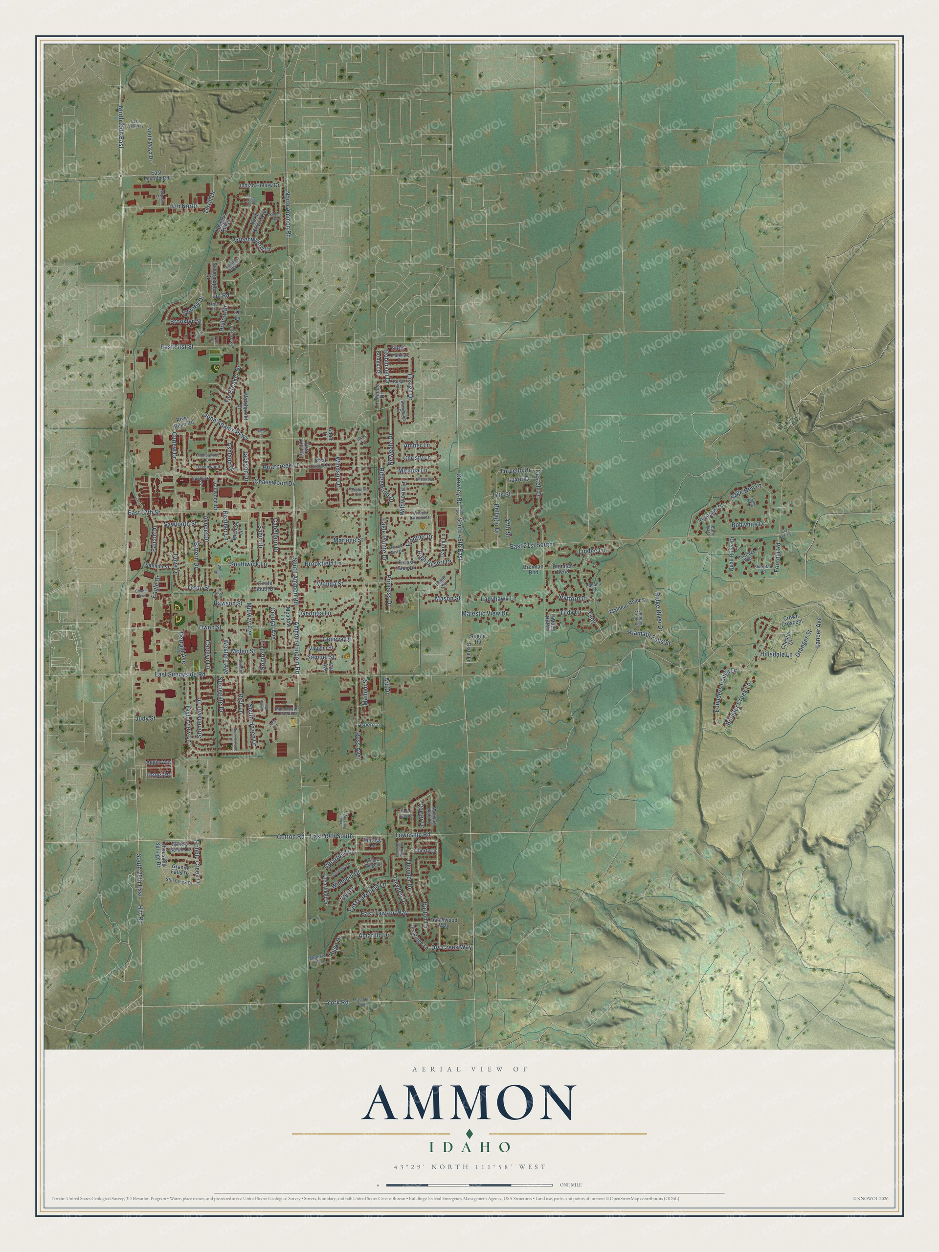
Ammon, Idaho Map Art
Building by building, with labeled streets and shaded relief.
12" x 18" Archival Matte Print
A Map of Home. A Work of Art.
Explore Ammon, Idaho from a whole new perspective. Created using aerial imagery and detailed geographic data, this map captures Ammon building by building, with labeled streets, familiar landmarks, and shaded topographical relief that highlights the natural contours of the landscape.
Combining modern data with the timeless character of a vintage atlas, this map is just as interesting up close as it is beautiful on the wall. Whether you grew up in Ammon, spent memorable years there, or call it home today, this unique map is a great way to celebrate a place that means something to you. Zoom in on the preview to look for your street, and then order a print to put your memories on the wall.
Three ways to hang it

Unframed archival matte, a black wood frame or a white wood frame.
Up close
Geography Worth Displaying
This map was created using accurate cartographic data and authoritative geographic sources, including the U.S. Geological Survey and the Census Bureau. The map brings together terrain, waterways, roads, and building detail. The majority of the streets are labeled, houses are accurately depicted, and the topography is derived from government sources. Combining local data with carefully composed color and shading leads to this beautifully detailed Ammon artwork for your wall.
Rather than simply showing street outlines, we’ve included as many of the street names as we could reasonably fit on the map while keeping their names legible. Zoom in on the high resolution preview to see exactly what’s on the map. We truly set out to create a statement piece for anyone who loves Ammon. So whether it’s for you, or a gift for someone you love, we hope this map of Ammon brings back fond memories.

Find your street
Names on the Ammon map
Every name below is printed on this map. Look for your street, your school, the park where you played, or the pond down the road.
Streets and roads206
- York Road
- Clearfield Lane
- Township Road
- Hitt Road
- North 25th East
- Ammon-Lincoln Road
- South Ammon Road
- Cotton Road
- Greenwillow Lane
- Teton Street
- John Adams Parkway
- Derrald Avenue
- Ensign Drive
- Lin Road
- East 17th Street
- East Sunnyside Road
- East 21st South
- Ross Avenue
- East 49th South
- Curlew Drive
- Midway Avenue
- Crowley Road
- South 45th East
- Chasewood Drive
- East First Street
- Eagle Drive
- Judy Street
- Wanda Street
- Taylorview Lane
- Tie Breaker Drive
Show all 206 streets
- South 25th East
- Boulder Creek Lane
- Stafford Drive
- Thunder Drive
- Founders Pointe Drive
- Falcon Drive
- Owen Street
- Barton Lane
- Foothill Road
- 14th North
- North Ammon Road
- Rawson Street
- Castelli Drive
- East Tawzer Way
- Georgia Lane
- Avocet Drive
- Klamath Falls Street
- Cabellaro Drive
- Rich Lane
- Romrell Lane
- Bellagio Drive
- Stonehaven Drive
- Briarcreek Lane
- Treyden Drive
- Hollow Drive
- Sage Hen Lane
- Central Avenue
- Western Avenue
- Tildy Lane
- Bobwhite Drive
- Molen Street
- Dove Drive
- Newgate Drive
- Brookfield Lane
- Windsor Drive
- Lancer Avenue
- 47th Street
- Bittern Drive
- Tildy
- Southwick Lane
- East Lakefield Lane
- South Hazen Drive
- Heather Lane
- Sydney Drive
- Ladyhawk Lane
- Sabin Drive
- High Desert Drive
- Ridge River Drive
- Samuel Street
- Ridgewood Drive
- Granger Street
- Geneva Drive
- Hobble Creek Drive
- Amarillo Drive
- Majestic View Drive
- Frontier Drive
- Wildwood Lane
- Eagle Pointe Drive
- Dry Creek Way
- Carolyn Lane
- Torcello Drive
- Princess Drive
- Mirinda Lane
- Sawtooth Street
- Ashland Drive
- Stonegate Drive
- Hillsdale Lane
- Veil Drive
- Windmill Drive
- Robinson Drive
- Jackson Drive
- Maiben Street
- Marlene Street
- Brooklyn Street
- Mason Street
- Terrill Drive
- Luxor Drive
- Hugo Drive
- Amber Lane
- Christy Lane
- Lindee Lane
- Porter Drive
- 17th Street
- Rebel Road
- Niles
- Ard Drive
- Silvermaple Drive
- Crown Crescent
- Rustle Road
- Clearfield Drive
- Hazelwood Way
- East Lincoln Road
- Indian Hollow Drive
- Meadow Lane
- North Robin Avenue
- Pheasant Drive
- Salmon Street
- Malheur River Street
- Brennan Bend
- Thousand Springs Drive
- Trappers Ridge
- Forest Glen Drive
- Matchpoint Drive
- Granite Falls Drive
- Spring Gulch Drive
- Bridger Drive
- North Maya Drive
- Quail Ridge Drive
- Vaughn Street
- Spencer Lane
- Trailwood Drive
- Holladay Drive
- Dry Ridge Lane
- Circle South Drive
- Briar Creek Lane
- River Bend Road
- Vintage Lane
- Dakota Lane
- Liberty Drive
- Aggie Way
- Chester Drive
- Aspen Lane
- Riata Lane
- Vista Villa Road
- Brennan Bnd
- Dal Avenue
- Hidden Hutch
- Kit Lane
- Adam Lane
- Ileen Circle
- Willow Ridge Drive
- Willow Canyon Drive
- Mountain Bend Drive
- Still Creek Drive
- Juniper Creek Drive
- Rulan Drive
- Partridge Way
- Barbwood Drive
- Sharptail Road
- Devonwood
- Manchester United Road
- Red Fox Drive
- Modesto Drive
- Mathews Drive
- Sunburst Drive
- 60th East
- Cross Lane
- Orchard Circle
- Cabana Drive
- Autumnwood
- Williams Street
- Yvonne Way
- Blue Grass Lane
- 45th East
- East 65th South
- Church Street
- Robins Avenue
- Trappers Ridge Street
- Rosedale Lane
- Birchwood Circle
- Chimney Rock Drive
- East Logo Way
- Summerwood Lane
- Sweet Water Way
- Brettonwood Drive
- Morning Mist Drive
- Sage Hen Court
- Brianne Avenue
- Majestic Circle
- Hillam Drive
- East Lydia Street
- Pond View Drive
- Laura Circle
- Clara Court
- First Street
- Judy Circle
Names are listed as they appear on the printed map. Zoom into the product photos to find them.
About Ammon, Idaho
Ammon is a city of 17,694 people in Bonneville County, just east of Idaho Falls. Latter-day Saints settled here in 1888. Their congregation started out as a dependent branch at the south end of the Iona ward, so the settlement was first known as South Iona. In 1889 the church made it a ward of its own, with Arthur M. Rawson as bishop.
Now that the ward no longer belonged to Iona, it needed a new name. Rawson chose Ammon, a missionary in the Book of Mormon, and the change took effect in 1893. The farm village was incorporated as a city on October 10, 1905. By 1930 it had 270 residents, while about 1100 people lived in the wider Ammon district.
- A grain elevator on the railsAmmon began as a farming center. It later had several general stores, a brickyard and the Ammon Elevator. In the early 1900s the Union Pacific Railroad built a spur line out to the elevator.
- A suburb since the 1940sNew housing divisions began going up in the 1940s, and Ammon grew into a suburb of Idaho Falls. In 1963 the state of Idaho raised its standing to a Second Class City. Both homes and businesses boomed in the 1990s.
- 123.3% growth in a decadeBetween 2000 and 2010 Ammon's population grew by 123.3%, one of the fastest rates in Idaho, and reached 13,816. By 2020 it was the state's 15th most populous city and the second largest in the Idaho Falls metro area.
- Its own fiber networkThe city builds, owns and runs a fiber-to-the-premises network. Outside internet providers use the city's fiber to reach their customers.
Keep exploring Idaho
Ammon is one of 279 Idaho towns we've mapped. Every dot on the map is a print of its own.
The search covers every state, Idaho first.
Near Ammon
Order 2 or more town maps and save 10%. Shown in the size and finish you picked above, so they hang as a set.
- Lincoln 12" x 18" / Archival Matte Print $39.99
- Idaho Falls 12" x 18" / Archival Matte Print $39.99
- Iona 12" x 18" / Archival Matte Print $39.99


The art of mapping a place
How This Map Was Made
Real places. Remarkable detail. Discover the layers that turn geographic data into a map of home.

The view from above
Aerial imagery reveals the character of the land: woodland, open fields, and the patterns of a place.

The shape of the land
Elevation data brings hills, valleys, and subtle changes in the landscape into view.

The details of home
Roads, waterways, and building footprints come together to make the map feel unmistakably local.

Geography becomes art
Considered color, shading, and typography bring the layers together in a map made for your wall.


Process illustrated with Mendon, Massachusetts. Aerial imagery: USDA NAIP. Terrain: USGS 3D Elevation Program. Map details and finished artwork: KNOWOL.
The Details
About This Print
Choose an archival matte print, or a black or white Ayous wood frame. The archival matte print is unframed.
Select your size and finish above to see the matching product image and price.
Materials & Craftsmanship
A contemporary map with the character of a classic atlas, printed on archival matte paper. Optional frames are made from Ayous wood.
Your printed map does not include the watermark shown in the full-map preview.
Shipping & Delivery
Free shipping within the United States. Every print is made to order in the USA.
Buying a gift? Add a note in your cart and we'll include it. We never put prices in the package.
Prints ship within 2 to 3 business days. Allow 7 to 10 days total from ordering for delivery. Timing may vary during holidays or periods of high order volume.
Read our shipping policy.
Returns and damaged prints
Each print is made to order. Change-of-mind refunds are not available after production.
If your print arrives damaged, misprinted or incorrect, contact support@knowol.com within 30 days of receiving it. Include your order number, photos and a description of the issue.
Read our full refund and replacement policy. For questions about your order, email support@knowol.com.