
Search for another town


Free U.S. delivery 7 to 10 days after you order
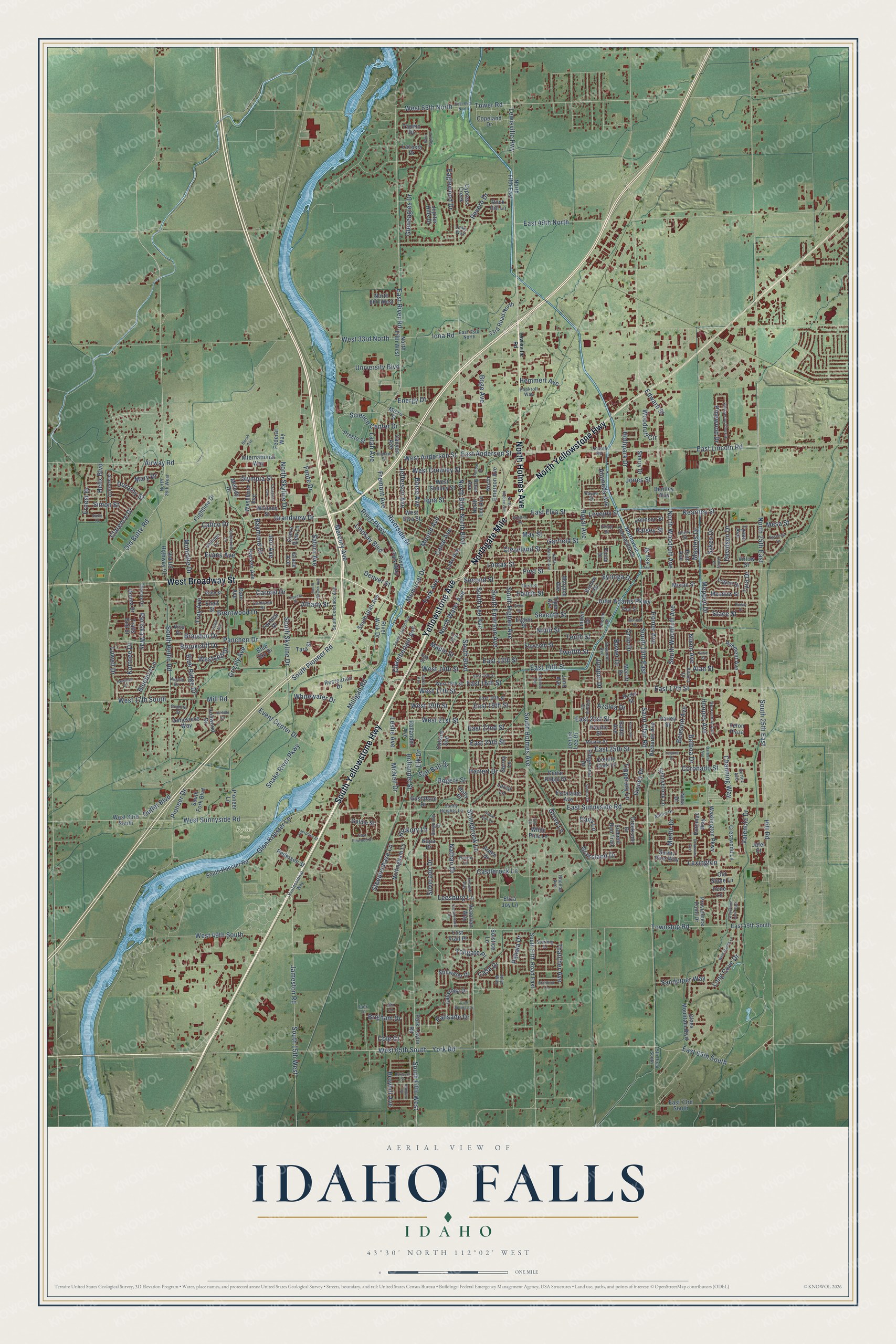
Idaho Falls, Idaho Map Art
Building by building, with labeled streets and shaded relief.
12" x 18" Archival Matte Print
A Map of Home. A Work of Art.
Explore Idaho Falls, Idaho from a whole new perspective. Created using aerial imagery and detailed geographic data, this map captures Idaho Falls building by building, with labeled streets, familiar landmarks, and shaded topographical relief that highlights the natural contours of the landscape.
Combining modern data with the timeless character of a vintage atlas, this map is just as interesting up close as it is beautiful on the wall. Whether you grew up in Idaho Falls, spent memorable years there, or call it home today, this unique map is a great way to celebrate a place that means something to you. Zoom in on the preview to look for your street, and then order a print to put your memories on the wall.
Three ways to hang it

Unframed archival matte, a black wood frame or a white wood frame.
Up close
Geography Worth Displaying
This map was created using accurate cartographic data and authoritative geographic sources, including the U.S. Geological Survey and the Census Bureau. The map brings together terrain, waterways, roads, and building detail. The majority of the streets are labeled, houses are accurately depicted, and the topography is derived from government sources. Combining local data with carefully composed color and shading leads to this beautifully detailed Idaho Falls artwork for your wall.
Rather than simply showing street outlines, we’ve included as many of the street names as we could reasonably fit on the map while keeping their names legible. Zoom in on the high resolution preview to see exactly what’s on the map. We truly set out to create a statement piece for anyone who loves Idaho Falls. So whether it’s for you, or a gift for someone you love, we hope this map of Idaho Falls brings back fond memories.
Read the story behind this map of Idaho Falls, Idaho from 2026.

Find your street
Names on the Idaho Falls map
Every name below is printed on this map. Look for your street, your school, the park where you played, or the pond down the road.
Places and landmarks1
- Ryder Park
Streets and roads396
- South Yellowstone Highway
- Northgate Mile
- Yellowstone Avenue
- North Yellowstone Highway
- West Broadway Street
- North Holmes Avenue
- Pancheri Drive
- East Lincoln Road
- East Anderson Street
- Grandview Drive
- West 65th South
- West Anderson Street
- West 17th Street
- Science Center Drive
- Old Butte Road
- East River Road
- North Boulevard
- East 21st Street
- South Holmes Avenue
- East 25th Street
- Lindsay Boulevard
- South Bellin Road
- Pevero Drive
- West 49th South
- Saturn Avenue
- Hollipark Drive
- Jefferson Avenue
- Saint Clair Road
- Snake River Parkway
- West 65th North
Show all 396 streets
- South Skyline Drive
- Latah Avenue
- Calico Drive
- Fremont Avenue
- Lewisville Highway
- Meppen Drive
- Chamberlain Avenue
- Stace Street
- Energy Drive
- Easy Street
- Hitt Road
- South 25th East
- First Street
- East 17th Street
- South Woodruff Avenue
- John Adams Parkway
- Twelfth Street
- South 15th East
- Township Road
- North Woodruff Avenue
- West Sunnyside Road
- East Sunnyside Road
- York Road
- South Pioneer Road
- Channing Way
- South Boulevard
- South Higbee Avenue
- Ninth Street
- Milligan Road
- North Skyline Drive
- Garfield Street
- South Lee Avenue
- South Fifth West
- South Emerson Avenue
- Hemmert Avenue
- Jameston Road
- South 15th West
- West 17th South
- Mill Road
- Tenth Street
- Hoopes Avenue
- West 33rd North
- Iona Road
- East 16th Street
- Memorial Drive
- East Elva Street
- North 25th East
- Rollandet Street
- Foote Drive
- Riverside Drive
- Glen Koester Lane
- Kearney Street
- East 13th Street
- East 14th Street
- Seventh Street
- River Parkway
- Tower Road
- Balboa Drive
- May Street
- Gleneagles Drive
- Lomax Street
- East 65th South
- Clarence Drive
- Castlerock Lane
- Cleveland Street
- Stonebrook Lane
- Long Cove Drive
- Hartert Drive
- Grizzly Avenue
- Nathan Drive
- Brentwood Drive
- Homer Avenue
- Coronado Street
- Fourth Street
- Olympia Street
- Eaglewood Drive
- West Crowley Street
- Mercury Avenue
- Valencia Drive
- Iona Street
- Brandon Drive
- West 19th Street
- West 21st Street
- Second Street
- Mesa Street
- Bluebird Lane
- Sykes Drive
- Ernest Drive
- Merlin Drive
- Masters Drive
- Raymond Drive
- Outlet Boulevard
- Event Center Drive
- Brookcliff Drive
- Boge Avenue
- Park Avenue
- Royal Avenue
- Periska Way
- Woodruff Circle
- Davidson Drive
- McNeil Drive
- Rogers Street
- East 49th North
- Silverado Drive
- Casa Drive
- Evans Avenue
- Boise Avenue
- Troy Avenue
- East 19th Street
- Pioneer Drive
- Sandpiper Way
- East 22nd Street
- North Water Avenue
- Canal Avenue
- East 24th Street
- Jones Street
- University Boulevard
- Pinewood Drive
- Syringa Drive
- Soft Ball Drive
- Blue Ridge Drive
- Westcliff Drive
- Bower Drive
- Airway Road
- Halsey Street
- Simon Street
- Moonlite Drive
- Steeplechase Lane
- Tyra Drive
- Helix Boulevard
- Tipperary Lane
- Broyhill Avenue
- Maple Street
- Belmont Avenue
- West 14th Street
- Grassland Drive
- Alan Street
- Leslie Avenue
- Disney Drive
- Lowell Drive
- Whitewater Drive
- Edward Street
- Thatcher Avenue
- Carmel Drive
- Alameda Avenue
- Lexington
- Hickory Lane
- Palisade Drive
- Dorothy Street
- Brigham Drive
- Pahala Drive
- Leesburg Lane
- Albany Street
- Azalea Drive
- Juniper Drive
- Nixon Avenue
- Mound Avenue
- Tollgate Place
- Lovejoy Street
- Kortnee Drive
- Mary Drive
- Jeri Avenue
- Orlin Drive
- Denver Street
- Grove Lane
- Dairy Lane
- Elk Drive
- Cole Court
- South Utah Avenue
- Old US Highway 91
- Jennie Lee Drive
- North Fifth West
- North Fifth East
- Gustafson Drive
- East 49th South
- Canyon Avenue
- South Koester Road
- Eleventh Street
- Rollandet Avenue
- Eighth Street
- Park-Taylor Road
- North Emerson Avenue
- West Shelley Street
- Presto Street
- Ashment Avenue
- Calkins Avenue
- Glass Mountain Boulevard
- West Elva Street
- River Park Way
- Linden Drive
- Washington Parkway
- North Lee Avenue
- International Way
- Escalante Avenue
- Northwest Bonneville Drive
- South Fifth Road East
- West 33rd South
- Jupiter Hills Drive
- River Walk Drive
- Richards Avenue
- June Avenue
- Nottingham Lane
- Stillwater Drive
- Ruth Avenue
- Johnson Street
- 33rd Road North
- Creekside Drive
- Ironwood Drive
- Merritt Drive
- Calistoga Drive
- Summit Run Trail
- Blue Sky Drive
- Pedersen Street
- Sunny Pine Way
- Claire View Lane
- Washburn Avenue
- Potomac Way
- Crestwood Lane
- Hansen Avenue
- Solstice Lane
- Trails End Street
- Recreation Drive
- Donna Drive
- Sunnybrook Lane
- Logan Drive
- East 73rd South
- Genevieve Way
- County Cork Lane
- Cypress Creek
- Copeland Drive
- Lake Avenue
- Melody Drive
- Whitney Street
- Meadow Street
- Tiger Avenue
- South Fork Boulevard
- Dale Avenue
- Pioneer Lane
- Flightline Drive
- Federal Way
- White Pine Lane
- Providence Point Drive
- North 660 West
- Cedar Ridge Drive
- Eliza Joy Lane
- Sherry Drive
- Ridgecrest Drive
- Terrace Drive
- Old Stone Lane
- Viva Drive
- Virlow Street
- Rock Hill Lane
- Marjacq Avenue
- Goldie Street
- Barlow Drive
- Enell Street
- Tapitio Drive
- Lacosta Drive
- Bentley Way
- Victorian Way
- Moran Street
- Baltic Avenue
- Pacific Street
- Micro Street
- Parley Street
- Napa Drive
- Arden Drive
- Teton Plaza
- Tara Street
- Lariat Lane
- Ricks Street
- Lost Trail Place
- Surrey Lane
- Tyson Avenue
- Holly Place
- Rose Avenue
- Pinon Drive
- Jafer Court
- Grace Avenue
- Irene Lane
- Nina Drive
- Lincoln Road
- North 26th West
- South Colorado Avenue
- Third Street
- Lincoln Drive
- Professional Way
- Mojave Street
- West 16th Street
- East 18th Street
- Henryanna Avenue
- Elm Street
- Irving Street
- Calliope Lane
- Riviera Drive
- Alayssa Drive
- East 33rd North
- Payne Street
- Susanne Avenue
- Sterling Drive
- Camrose Street
- Sunny Heights Lane
- Thomas Drive
- Popkroll Way
- Jolyn Way
- Harold Drive
- Antler Drive
- Haven Lane
- Burgundy Drive
- 15th Road South
- Robb Street
- Tiffany Drive
- Cortez Avenue
- Paul Street
- Granite Street
- Rhonda Avenue
- Henry Street
- Links Way
- Jack Lane
- Oak Street
- Jex Lane
- Lewisville Road
- East 15th Street
- Eastview Drive
- North Higbee Avenue
- Whittier Street
- Cranmer Avenue
- Newman Drive
- South Capital Avenue
- Curtis Avenue
- North Wabash Avenue
- East 65th North
- Colonial Way
- East Elswood Drive
- Sixth Street
- Wild Dunes Lane
- Sun Circle
- Whispering Pines Drive
- Laguna Drive
- South Saturn Avenue
- Bodily Street
- Valley Drive
- Delaware Avenue
- Dunbar Drive
- Borah Avenue
- Laprele Street
- Cumberland Drive
- Higham Street
- Singletree Lane
- Crescent Avenue
- Greystone Lane East
- Stone Run Lane
- Enterprise Street
- Glen Eagle Drive
- Adell Avenue
- Sonora Drive
- Bradford Lane
- Saddle Lane
- Barbara Avenue
- Stella Drive
- Roxbury Street
- Koro Avenue
- Cold Springs Drive
- Benton Street
- Hamden Street
- Ririe Circle
Names are listed as they appear on the printed map. Zoom into the product photos to find them.
About Idaho Falls, Idaho
Idaho Falls is a city of 64,818 people and the seat of Bonneville County, on the Snake River in eastern Idaho. In 1864 Harry Rickets started a ferry across the Snake for travelers on the Montana Trail. Soon after, the freighter Matt Taylor put a wooden toll bridge over a narrow basalt gorge 7 miles downstream. By the end of 1865 a bank, a hotel, a livery stable, a post office and a stage station stood near his bridge.
People first called the place Taylor's Crossing. By 1866 it was Eagle Rock, named for a basalt island near the ferry where about twenty eagles nested. The Utah and Northern Railway reached town in late 1878 and crossed the river at Taylor's gorge, bringing train service and railroad shops. In 1887 most of those shops moved to Pocatello, and the town nearly died. Leaders renamed it Idaho Falls in 1891 for the rapids below the bridge. The Great Feeder canal opened on June 22, 1895, and its irrigated farms brought the city back.
- An iron bridge in 1879The railroad had a new iron bridge built in Athens, Pennsylvania, for $30,000 and shipped it west by train. Crews raised it over the Snake in April and May 1879. It stretched 800 feet and was split into two spans by an island. A rowdy tent camp of saloons and gambling halls had followed the grading crews, but it moved on, and the town kept its trains.
- First nuclear electricity, 1951The Atomic Energy Commission set up the National Reactor Testing Station on the desert west of town in 1949. There, on December 20, 1951, a reactor made usable electricity for the first time anywhere. The site grew into the Idaho National Laboratory, which with its contractors now employs more than 8,000 people.
- A zoo since 1935Tautphaus Park has been home to the Idaho Falls Zoo since 1935, and the zoo now keeps more than 300 animals. It also runs Funland, a small amusement park from 1947 that has been fully restored.
Keep exploring Idaho
Idaho Falls is one of 279 Idaho towns we've mapped. Every dot on the map is a print of its own.
The search covers every state, Idaho first.
Near Idaho Falls
Order 2 or more town maps and save 10%. Shown in the size and finish you picked above, so they hang as a set.
- Lincoln 12" x 18" / Archival Matte Print $39.99
- Ammon 12" x 18" / Archival Matte Print $39.99
- Iona 12" x 18" / Archival Matte Print $39.99


More maps nearby: Ucon, Shelley, Basalt, Rigby and Lewisville.
The art of mapping a place
How This Map Was Made
Real places. Remarkable detail. Discover the layers that turn geographic data into a map of home.

The view from above
Aerial imagery reveals the character of the land: woodland, open fields, and the patterns of a place.

The shape of the land
Elevation data brings hills, valleys, and subtle changes in the landscape into view.

The details of home
Roads, waterways, and building footprints come together to make the map feel unmistakably local.

Geography becomes art
Considered color, shading, and typography bring the layers together in a map made for your wall.


Process illustrated with Mendon, Massachusetts. Aerial imagery: USDA NAIP. Terrain: USGS 3D Elevation Program. Map details and finished artwork: KNOWOL.
The Details
About This Print
Choose an archival matte print, or a black or white Ayous wood frame. The archival matte print is unframed.
Select your size and finish above to see the matching product image and price.
Materials & Craftsmanship
A contemporary map with the character of a classic atlas, printed on archival matte paper. Optional frames are made from Ayous wood.
Your printed map does not include the watermark shown in the full-map preview.
Shipping & Delivery
Free shipping within the United States. Every print is made to order in the USA.
Buying a gift? Add a note in your cart and we'll include it. We never put prices in the package.
Prints ship within 2 to 3 business days. Allow 7 to 10 days total from ordering for delivery. Timing may vary during holidays or periods of high order volume.
Read our shipping policy.
Returns and damaged prints
Each print is made to order. Change-of-mind refunds are not available after production.
If your print arrives damaged, misprinted or incorrect, contact support@knowol.com within 30 days of receiving it. Include your order number, photos and a description of the issue.
Read our full refund and replacement policy. For questions about your order, email support@knowol.com.