


Search for another town


Free U.S. delivery 7 to 10 days after you order
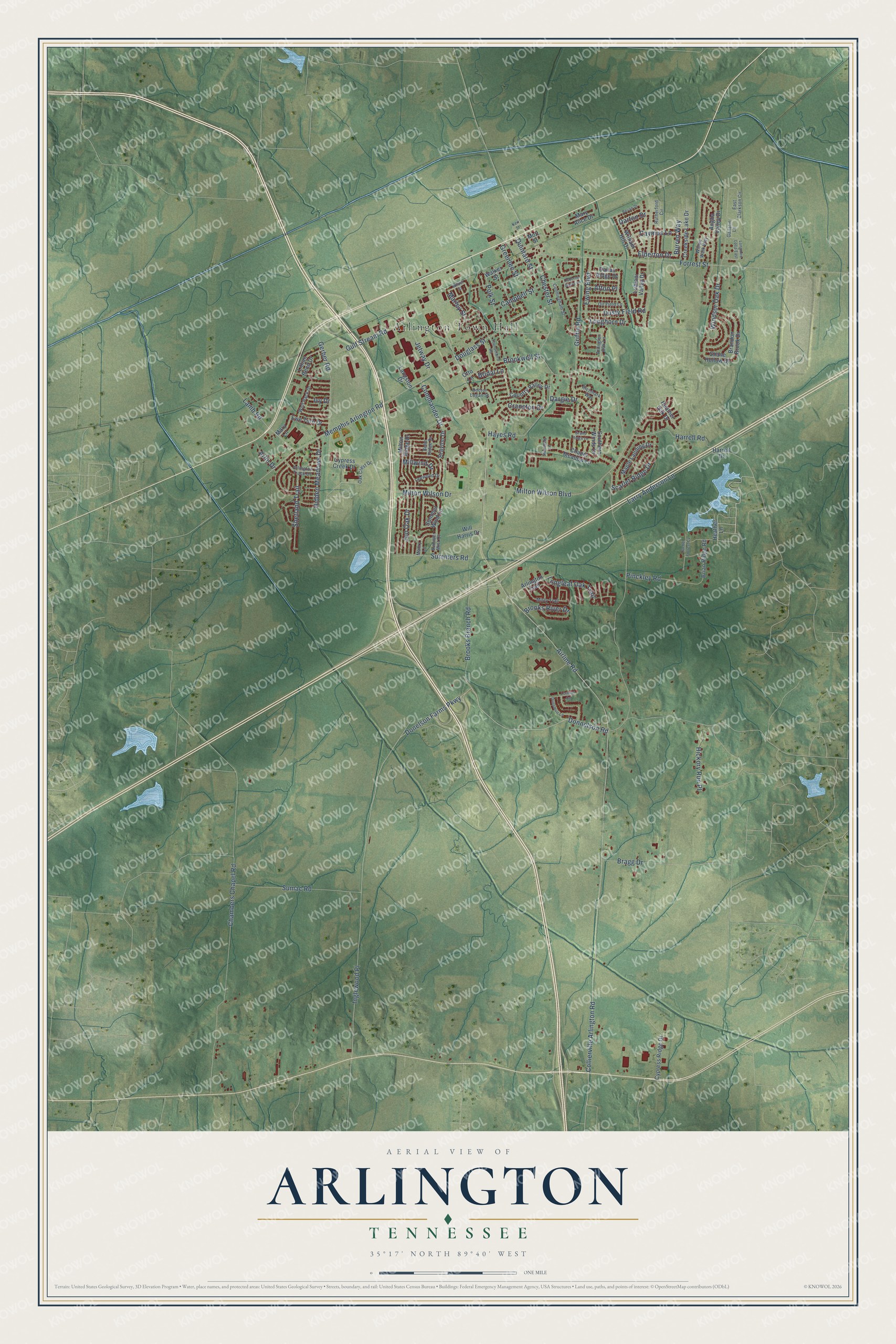
Arlington, Tennessee Map Art
Building by building, with labeled streets and shaded relief.
12" x 18" Archival Matte Print
A Map of Home. A Work of Art.
Explore Arlington, Tennessee from a whole new perspective. Created using aerial imagery and detailed geographic data, this map captures Arlington building by building, with labeled streets, familiar landmarks, and shaded topographical relief that highlights the natural contours of the landscape.
Combining modern data with the timeless character of a vintage atlas, this map is just as interesting up close as it is beautiful on the wall. Whether you grew up in Arlington, spent memorable years there, or call it home today, this unique map is a great way to celebrate a place that means something to you. Zoom in on the preview to look for your street, and then order a print to put your memories on the wall.
Three ways to hang it

Unframed archival matte, a black wood frame or a white wood frame.
Up close
Geography Worth Displaying
This map was created using accurate cartographic data and authoritative geographic sources, including the U.S. Geological Survey and the Census Bureau. The map brings together terrain, waterways, roads, and building detail. The majority of the streets are labeled, houses are accurately depicted, and the topography is derived from government sources. Combining local data with carefully composed color and shading leads to this beautifully detailed Arlington artwork for your wall.
Rather than simply showing street outlines, we’ve included as many of the street names as we could reasonably fit on the map while keeping their names legible. Zoom in on the high resolution preview to see exactly what’s on the map. We truly set out to create a statement piece for anyone who loves Arlington. So whether it’s for you, or a gift for someone you love, we hope this map of Arlington brings back fond memories.
Read the story behind this map of Arlington, Tennessee from 2026.

Find your street
Names on the Arlington map
Every name below is printed on this map. Look for your street, your school, the park where you played, or the pond down the road.
Places and landmarks1
- Arlington Town Hall
Streets and roads112
- Donnelson Road
- Burren Way
- Marley Street
- Donelson Farms Parkway
- Elderton Drive
- Inglewood Place
- Airline Road
- Shetland Trail
- Jon Oak Drive
- Bragg Drive
- Longhorn Drive
- Chester Street
- Milton Wilson Boulevard
- Chambers Chapel Road
- Memphis Arlington Road
- Milton Wilson Drive
- Forrest Street
- Collierville Arlington Road
- Sumac Road
- Brooks Branch Road
- Larry Anderson Lane
- Griffin Road
- Hayes Road
- Lamb Road
- Douglass Street
- Gerber Road
- Summers Road
- Polk Street
- Jetway Drive
- Gulf Stream Road
Show all 112 streets
- Harrell Road
- Pinckley Road
- Campbell Street
- Windsor Oak Drive
- Cranston Drive
- Hidden Meadows Drive
- Hickory Run Place
- Dusty Field Road
- Scarlet Ridge Drive
- Quintard Street
- Ewing Boulevard
- Dargie Drive
- Longleaf Oak Trail
- Greenlee Street
- Commander Drive
- Caymus Lane
- Brooks River Drive
- Brockwell Street
- Millwind Drive
- Darton Drive
- Arlin Drive
- Bridal Lane
- Afton Place
- Ivy Drive
- Heather Lane
- Milton Ridge Drive
- Heather Oak Drive
- Cypress Creek Drive
- Maple Landing Drive
- Southern Winds Drive
- Brandon Brook Drive
- Creekside Lake Drive
- Walker Street
- Chapel Meadow Lane
- Anglia Valley Drive
- Arlington Trail
- Cypress Ridge Drive
- Country Valley Drive
- Mary Alice Drive
- Summer Wind Lane
- Brian Ridge Road
- William Hill Drive
- Mott Street
- Ewe Turn Drive
- Lillian Bend Drive
- Will Harris Drive
- Brayton Drive
- Shane Hollow Drive
- Lubiani Valley Drive
- Dallas Ridge Drive
- Langston Drive
- Mary Lane
- Otto Lane
- Harrell Drive
- Arlington Oak Lane
- Richmark Way
- Rutherford Circle
- Misty Trail
- Arlington Trace Drive
- Cunningham Street
- Wolf Pack Drive
- Oil Field Lane
- East Clarkson Circle
- Mabry Lane
- Oak Crest Drive
- Willow Walk Way
- Doctor Logan Street
- Summer Mist Cv
- Leewood Drive
- Belle Ridge Drive
- Gallatin Lane
- Wilder Street
- Dunsmuir Lane
- Bevan Drive
- Thunderbird Road
- Grand Ridge Lane
- Rachel Forrest Cv
- Longmire Loop East
- Stansbury Lane
- Osborne Grove Drive
- Lorimer Cv
- Kerr Street
Names are listed as they appear on the printed map. Zoom into the product photos to find them.
About Arlington, Tennessee
Arlington is a town of 14,549 people in Shelby County. The Chickasaw Nation lived here until the Treaty of Tuscaloosa gave this part of West Tennessee to the United States, and Shelby County was created on November 24, 1819. Fewer than 20 settlers lived in the young community in the 1830s, but by 1856 about 200 people farmed the area, most of them growing cotton.
Those farmers needed a way to ship their crop. Samuel J. Hays, a general and a nephew of President Andrew Jackson, donated land for Withe Depot on the Memphis, Clarksville and Louisville Railroad, and the depot became the place where local cotton left for market. In gratitude the community took the name Haysville.
- From Haysville to ArlingtonMany men left for the Civil War, and many never returned. The Hays estate was divided into lots and auctioned in 1872, its streets named for General Nathan Bedford Forrest, Colonel Robert I. Chester, Bishop Charles Quintard and Andrew Jackson. On February 10, 1878, Haysville became a town with W.B. Nolley as mayor. Seeking a post office in 1883, officials found Tennessee already had a Haysville, so depot agent Captain Henry Pitman suggested Arlington, for the Virginia national cemetery.
- A yellow fever quarantineYellow fever swept the region soon after Haysville incorporated. To keep the epidemic out, town officials shut the town to outsiders, and early mayors such as Dr. J.P. Bone, H.Y. Marley, C.C. Poole and W.I. Hooks guided residents through the crisis.
- The AccommodationA local train known as "The Accommodation" carried Haysville people to jobs and schools in Memphis. The engineer, flagman and conductor knew their regular riders, and stories say they sometimes eased off the throttle so a late passenger running from home could still climb aboard.
- A Rosenwald school, 1924-25Wells School went up in 1924-25, at the peak of the building program that the Rosenwald fund helped pay for. It joined the National Register in 1995.
- The depot returns in 2003Depot Square has long been where Arlington gathers, from the old Brunswick Stew town reunion to Arlington in April, Music on the Square, the Harvest Gathering and the Christmas Parade. In 2003 the town built a copy of its first railroad depot there, and it now houses the Arlington Senior Citizens Center.
Keep exploring Tennessee
Arlington is one of 640 Tennessee towns we've mapped. Every dot on the map is a print of its own.
The search covers every state, Tennessee first.
Near Arlington
Order 2 or more town maps and save 10%. Shown in the size and finish you picked above, so they hang as a set.
- Lakeland 12" x 18" / Archival Matte Print $39.99
- Gallaway 12" x 18" / Archival Matte Print $39.99
- Pisgah 12" x 18" / Archival Matte Print $39.99


More maps nearby: Oakland, Bolton, Bartlett, Braden and Mason.
The art of mapping a place
How This Map Was Made
Real places. Remarkable detail. Discover the layers that turn geographic data into a map of home.

The view from above
Aerial imagery reveals the character of the land: woodland, open fields, and the patterns of a place.

The shape of the land
Elevation data brings hills, valleys, and subtle changes in the landscape into view.

The details of home
Roads, waterways, and building footprints come together to make the map feel unmistakably local.

Geography becomes art
Considered color, shading, and typography bring the layers together in a map made for your wall.


Process illustrated with Mendon, Massachusetts. Aerial imagery: USDA NAIP. Terrain: USGS 3D Elevation Program. Map details and finished artwork: KNOWOL.
The Details
About This Print
Choose an archival matte print, or a black or white Ayous wood frame. The archival matte print is unframed.
Select your size and finish above to see the matching product image and price.
Materials & Craftsmanship
A contemporary map with the character of a classic atlas, printed on archival matte paper. Optional frames are made from Ayous wood.
Your printed map does not include the watermark shown in the full-map preview.
Shipping & Delivery
Free shipping within the United States. Every print is made to order in the USA.
Buying a gift? Add a note in your cart and we'll include it. We never put prices in the package.
Prints ship within 2 to 3 business days. Allow 7 to 10 days total from ordering for delivery. Timing may vary during holidays or periods of high order volume.
Read our shipping policy.
Returns and damaged prints
Each print is made to order. Change-of-mind refunds are not available after production.
If your print arrives damaged, misprinted or incorrect, contact support@knowol.com within 30 days of receiving it. Include your order number, photos and a description of the issue.
Read our full refund and replacement policy. For questions about your order, email support@knowol.com.