


Search for another town


Free U.S. delivery 7 to 10 days after you order
Bartlett, Tennessee Map Art
Building by building, with labeled streets and shaded relief.
12" x 18" Archival Matte Print
A Map of Home. A Work of Art.
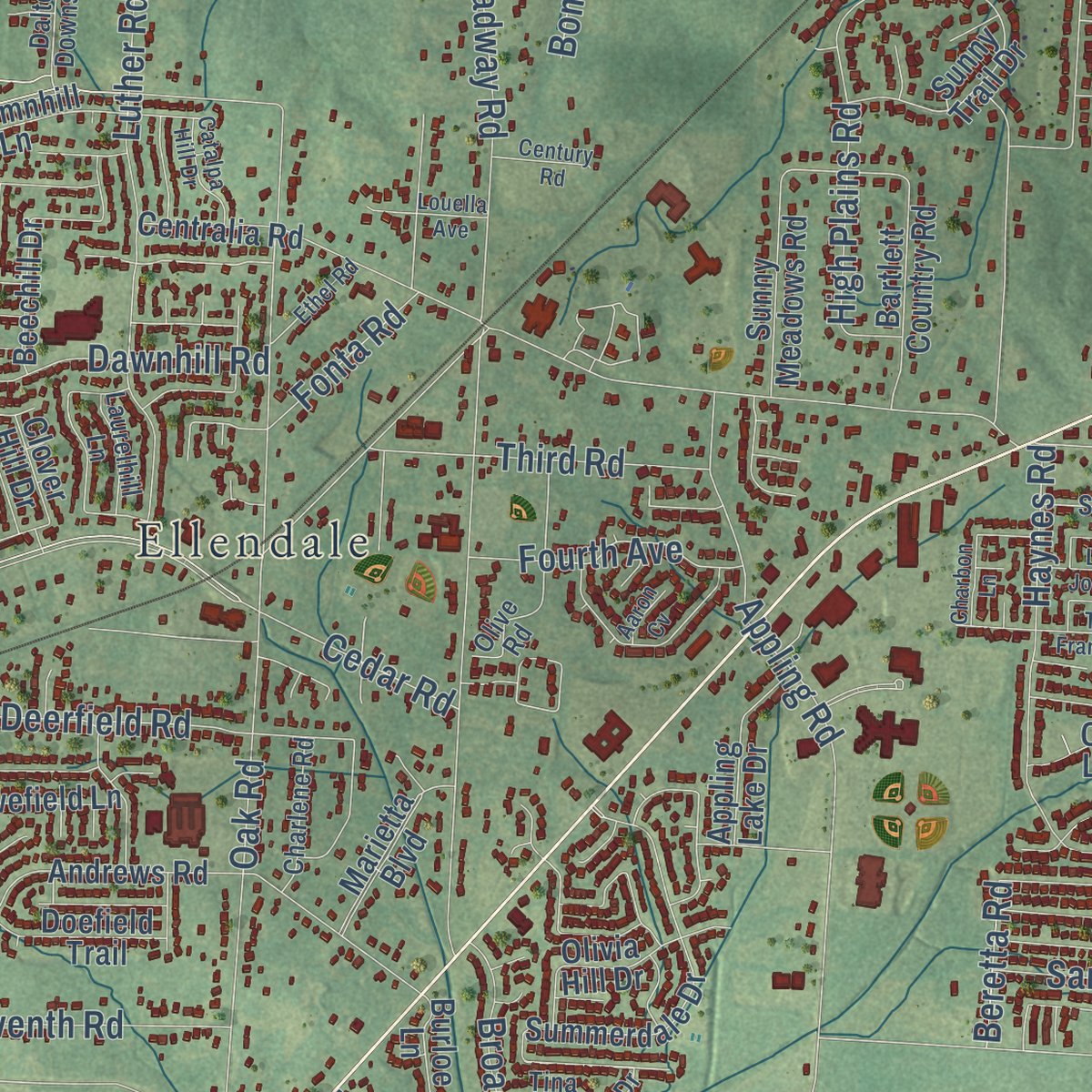
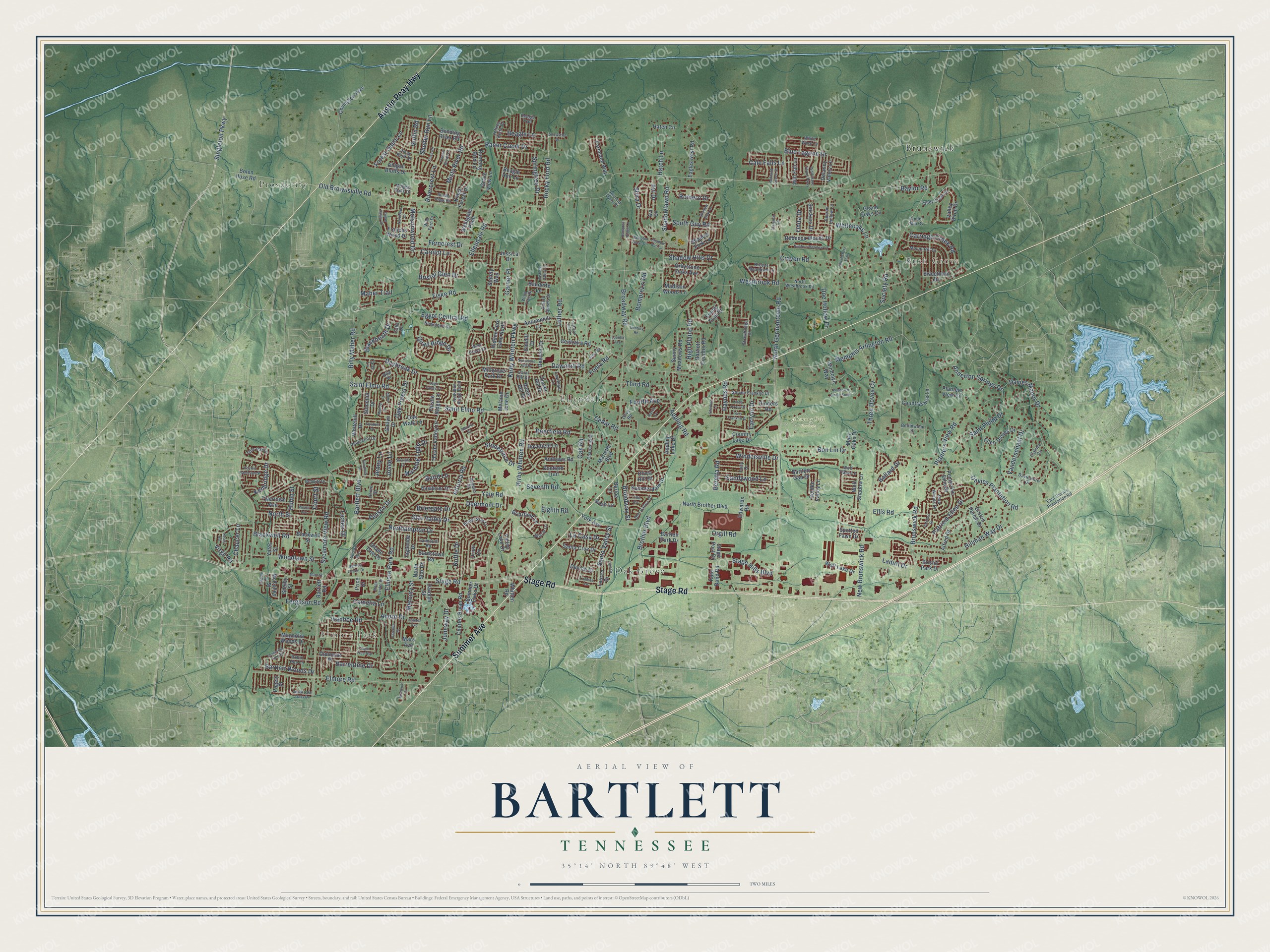
Explore Bartlett, Tennessee from a whole new perspective. Created using aerial imagery and detailed geographic data, this map captures Bartlett building by building, with labeled streets, familiar landmarks, and shaded topographical relief that highlights the natural contours of the landscape.
Combining modern data with the timeless character of a vintage atlas, this map is just as interesting up close as it is beautiful on the wall. Whether you grew up in Bartlett, spent memorable years there, or call it home today, this unique map is a great way to celebrate a place that means something to you. Zoom in on the preview to look for your street, and then order a print to put your memories on the wall.
Three ways to hang it

Unframed archival matte, a black wood frame or a white wood frame.
Up close
Geography Worth Displaying
This map was created using accurate cartographic data and authoritative geographic sources, including the U.S. Geological Survey and the Census Bureau. The map brings together terrain, waterways, roads, and building detail. The majority of the streets are labeled, houses are accurately depicted, and the topography is derived from government sources. Combining local data with carefully composed color and shading leads to this beautifully detailed Bartlett artwork for your wall.
Rather than simply showing street outlines, we’ve included as many of the street names as we could reasonably fit on the map while keeping their names legible. Zoom in on the high resolution preview to see exactly what’s on the map. We truly set out to create a statement piece for anyone who loves Bartlett. So whether it’s for you, or a gift for someone you love, we hope this map of Bartlett brings back fond memories.
Read the story behind this map of Bartlett, Tennessee from 2026.

Find your street
Names on the Bartlett map
Every name below is printed on this map. Look for your street, your school, the park where you played, or the pond down the road.
Places and landmarks7
- Prosperity
- Elmore Park
- Bush Grove
- Memory Hill Gardens
- Oak Grove
- Ellendale
- Brunswick
Streets and roads321
- Stage Road
- Summer Avenue
- Austin Peay Highway
- Kirby Whitten Parkway
- Kirby Whitten Road
- Ferncrest Drive
- Rocky Ford Road
- Old Brownsville Road
- Memphis Arlington Road
- North Germantown Road
- Yale Road
- Bartlett Boulevard
- Brunswick Road
- Saint Elmo Road
- Altruria Road
- Billy Maher Road
- Oak Road
- Brother Boulevard
- Appling Road
- Egypt Central Road
- Broadway Road
- Ellis Road
- Ellendale Road
- Elmore Park Road
- Shadowlawn Road
- Luther Road
- Elmore Road
- New Brunswick Road
- Westbrook Road
- Davies Manor Drive
Show all 321 streets
- Davies Plantation Road
- Ivanhoe Road
- Blackwell Road
- Raner Creek Drive
- Daybreak Drive
- Hillman Way Drive
- Craven Road
- Dawnhill Road
- Windersville Drive
- Fiske Road
- Saint Philip Drive
- Sycamore View Road
- Planters View Road
- Star Valley Drive
- Venson Drive
- High Plains Road
- Singleton Parkway
- Patricia Ellen Drive
- Quail Ridge Drive
- Court Street
- North Street
- Shelter Run Lane
- Earlynn Drive
- Guffin Road
- Oak Forest Drive
- Carolot Lane
- Woodlawn Street
- Three Doves Cv
- Shira Drive
- Rivercrest Lane
- Anderton Springs Drive
- Deerfield Road
- Misty River Road
- Bon Lin Drive
- Carriage Creek Road
- Garner Place
- Santa Valley Street
- Fonta Road
- Blue Lagoon Drive
- Haynes Road
- Vanderschaaf Drive
- Northampton Drive
- Whiteoaks Lane
- Stonetrace Drive
- Orgill Road
- Stage Hills Boulevard
- Third Road
- Juneway Drive
- Blackheath Drive
- Springtree Drive
- Baird Lane
- Seventh Road
- Ladurl Drive
- Shadow Hills Drive
- Ballard Drive
- Sandywood Lane
- Doe Hollow Drive
- Morning Light Drive
- Deermont Drive
- Bartlett Woods Drive
- Forest Oasis Lane
- Fourth Avenue
- Broadway Street
- Hatch Lane
- Bristol Glen Drive
- Molsonwood Drive
- Beagle Lane
- Society Road
- Cale Falls Lane
- South Guy Road
- Barrentine Drive
- La Casa Drive
- Chaucer Lane
- Acorn Drive
- Mercury Street
- Ferguson Road
- Kenbridge Drive
- Cedar Road
- Bomprezzi Road
- Romero Drive
- Virgil Road
- Onita Drive
- Baylor Road
- Briergate Drive
- Avi Drive
- Jenny Lane
- Maher Trail
- Camelia Lane
- Lichen Drive
- Eighth Road
- Josee Lane
- Beretta Road
- Hulon Street
- Ruffle Drive
- Valley Birch Drive
- Stonehill Drive
- Charles Bryan Road
- Andrews Road
- Shelby Street
- Blackwell Street
- Alfred Drive
- Pembroke Ellis Drive
- Summerdale Drive
- Bending River Road
- Centralia Road
- Marietta Boulevard
- Covington Pike
- Bolen Huse Road
- Autumnhill Lane
- North Brother Boulevard
- Yates Street
- North Star Drive
- Gailyn Drive
- Lauren Drive
- Bartlett Country Road
- Sunny Meadows Road
- Ellen Davies Drive
- Rebecca Woods Drive
- Baudette Lane
- Thistle Valley Lane
- Bristol Park Drive
- Summer Oaks Drive
- Santa Cruz Drive
- Darolyn Street
- Beagle Run Lane
- Shade Tree Drive
- Countryshire Lane
- Shadow Fork Lane
- Oak Walk Lane
- Magnolia Woods Drive
- Greystone Oaks Avenue
- Diplomat Place
- Sunny Trail Drive
- Beechill Drive
- Eagles Nest Road
- Farmland Way
- Eastbrier Drive
- Wolf Lake Drive
- Thistle Ridge Lane
- Wolf Shadow Lane
- Abigail Bluffs Drive
- Millgrove Park Drive
- Ingleside Drive
- Appling Lake Drive
- Hidden Fern Lane North
- Snickers Drive
- Will Fall Lane
- Robin Hill Drive
- Olivia Hill Drive
- Bartlett Road
- Doefield Trail
- Delaney Valley Lane
- Mary Oaks Drive
- Bruton Parish Drive
- Dovefield Lane
- Tylertown Avenue
- York Avenue
- Running Bird Lane
- Valley Lake Drive
- Briarfield Lane
- Windolyn Way
- Kate Bond Road
- Kings Forest Drive
- Bartlett Gap Drive
- McCulley Street
- Country Lake Drive
- Bardstown Road
- Sweethorn Drive
- Devine Street
- Golden Valley Lane
- Whitehill Drive
- Stage Post Drive
- Frances Wood Drive
- Wellsgate Point
- Melanie June Drive
- Edwards Road
- Cinders Road
- Spotted Fawn Drive
- Hatch Circle
- Madison Woods Lane
- Whitten Road
- Planters View Cv
- Bartlett Park Drive
- Noah Lane
- Mars Avenue
- Burloe Lane
- Grace View Lane
- Stately Way
- Clover Hill Drive
- Grand Oaks Cv
- Jessica Drive
- Pagely Place
- Elmhill Drive
- Price Drive
- Orion Cv
- Avi Cv
- Mount Hill Drive
- North Westbrook Road
- Davieshire Drive
- Olive Road
- Steven Franklin Drive
- Jeffrey Keith Drive
- Sara Woods Drive
- Newstone Drive
- Don Valley Drive
- Dalton Downs Drive
- East Davies Plantation Road
- Audubon Ridge Bend
- Bright Star Lane
- Valley Creek Drive
- Polly Drive
- Robin Hop Lane
- Charlene Road
- Angelin Drive
- Pine Oak Lane
- Beagle Trail
- Wild Fern Drive
- Breezy Meadows Lane
- Coral Hill Drive
- Strawbridge Drive
- Pebblehill Drive
- Piney Bluff Drive
- Berlinwood Drive
- Bobbitt Drive
- Falmouth Road
- Wolf Trace Lane
- Laurelhill Lane
- West Grove Drive
- Briarly Lane
- Bourne Hollow Lane
- Wind Tree Drive
- Kinder Mill Cv
- Gila Drive
- Maggie Oaks Drive
- Clairice Cv
- White Wing Lane
- Ancient Oaks Place
- Carla Lane
- Tina Cv
- Calla Drive
- Acree Street
- Windolyn Circle South
- Hunters Meadow Lane
- Flowering Tree Drive
- Skylight Drive
- Terry Franklin Drive
- Satellite Street
- Shadow View Lane
- Wolfchase Farms Parkway
- Gail Drive
- Narcissus Drive
- Patches Drive
- Lamesa Lane
- Stage Center Drive
- Pinola Avenue
- Bartlett Center Drive
- Sycamore Hill Drive
- Peyton Randolph Street
- Goforth Way
- Needle Ridge Road
- Old Hickory Trail
- Dylan Valley Drive
- Catalpa Hill Drive
- Ethel Road
- Linda Joyce Drive
- South Lake Oaks Drive
- Ashland Grove Street
- Eagle Valley Cv
- Brannick Drive
- Alfaree Street
- French Broad Lane
- Snowshoe Drive
- Century Road
- Adina Drive
- Flynthill Drive
- Hampton Grove Lane
- Keats Road
- Bishops Valley Lane
- Hampton Ridge Lane
- Sugar Tree Avenue
- Clarence Road
- Charbon Lane
- Mendel Drive
- Flintlock Drive
- Shadow Run Lane
- Fluss Road
- Altruria Court
- Main Street
- Louella Avenue
- Jupiter Avenue
- Aaron Cv
Names are listed as they appear on the printed map. Zoom into the product photos to find them.
About Bartlett, Tennessee
Bartlett is a city of 57,786 people in Shelby County. It began as Union Depot, the last big Tennessee stop on the stagecoach road west from Nashville. Later the Memphis & Ohio Railroad replaced the stagecoaches, and the depot became a rail station. A farm community slowly grew up around it.
The place stayed small until after the Civil War. It was incorporated on November 1, 1866, with fewer than 100 people, and Bryan Wither was its first mayor. Then it grew fast during Reconstruction. By 1886 it had about 300 people, a school, two gristmills, three churches and several general stores.
“It was named for Major Gabriel M. Bartlett, a planter, whose homeplace was located on the old Raleigh-Somerville Road (Stage) at the present location of Bartlett Station Plaza.”
- Art Garfunkel opened itThe Bartlett Performing Arts & Conference Center was finished in 1999. Art Garfunkel gave its first show.
- Its own schools since 2014Bartlett's schools were once part of Shelby County Schools. On July 16, 2013, Bartlett voters chose to form their own city school district. It opened in the fall of 2014 with the 11 school buildings in the city. David Stephens, once a top leader of Shelby County Schools, became its superintendent.
Keep exploring Tennessee
Bartlett is one of 640 Tennessee towns we've mapped. Every dot on the map is a print of its own.
The search covers every state, Tennessee first.
Near Bartlett
Order 2 or more town maps and save 10%. Shown in the size and finish you picked above, so they hang as a set.
- Lakeland 12" x 18" / Archival Matte Print $39.99
- Raleigh 12" x 18" / Archival Matte Print $39.99
- Bolton 12" x 18" / Archival Matte Print $39.99


More maps nearby: Pisgah, Millington, Arlington, Woodstock and East Memphis.
The art of mapping a place
How This Map Was Made
Real places. Remarkable detail. Discover the layers that turn geographic data into a map of home.

The view from above
Aerial imagery reveals the character of the land: woodland, open fields, and the patterns of a place.

The shape of the land
Elevation data brings hills, valleys, and subtle changes in the landscape into view.

The details of home
Roads, waterways, and building footprints come together to make the map feel unmistakably local.

Geography becomes art
Considered color, shading, and typography bring the layers together in a map made for your wall.


Process illustrated with Mendon, Massachusetts. Aerial imagery: USDA NAIP. Terrain: USGS 3D Elevation Program. Map details and finished artwork: KNOWOL.
The Details
About This Print
Choose an archival matte print, or a black or white Ayous wood frame. The archival matte print is unframed.
Select your size and finish above to see the matching product image and price.
Materials & Craftsmanship
A contemporary map with the character of a classic atlas, printed on archival matte paper. Optional frames are made from Ayous wood.
Your printed map does not include the watermark shown in the full-map preview.
Shipping & Delivery
Free shipping within the United States. Every print is made to order in the USA.
Buying a gift? Add a note in your cart and we'll include it. We never put prices in the package.
Prints ship within 2 to 3 business days. Allow 7 to 10 days total from ordering for delivery. Timing may vary during holidays or periods of high order volume.
Read our shipping policy.
Returns and damaged prints
Each print is made to order. Change-of-mind refunds are not available after production.
If your print arrives damaged, misprinted or incorrect, contact support@knowol.com within 30 days of receiving it. Include your order number, photos and a description of the issue.
Read our full refund and replacement policy. For questions about your order, email support@knowol.com.