
Search for another town





Free U.S. delivery 7 to 10 days after you order
Avon, Connecticut Map Art
Building by building, with labeled streets and shaded relief.
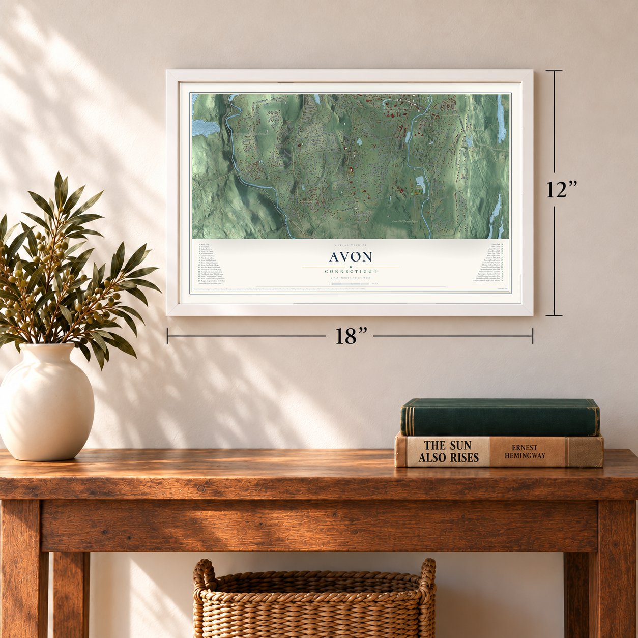
12" x 18" Archival Matte Print
A Map of Home. A Work of Art.
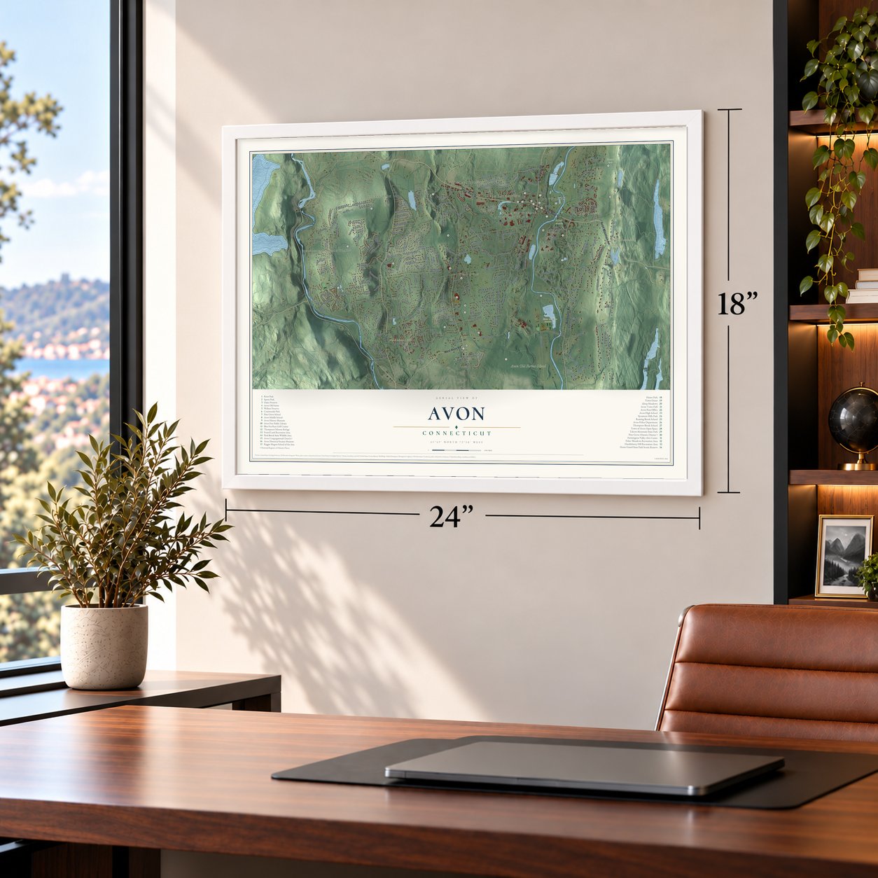
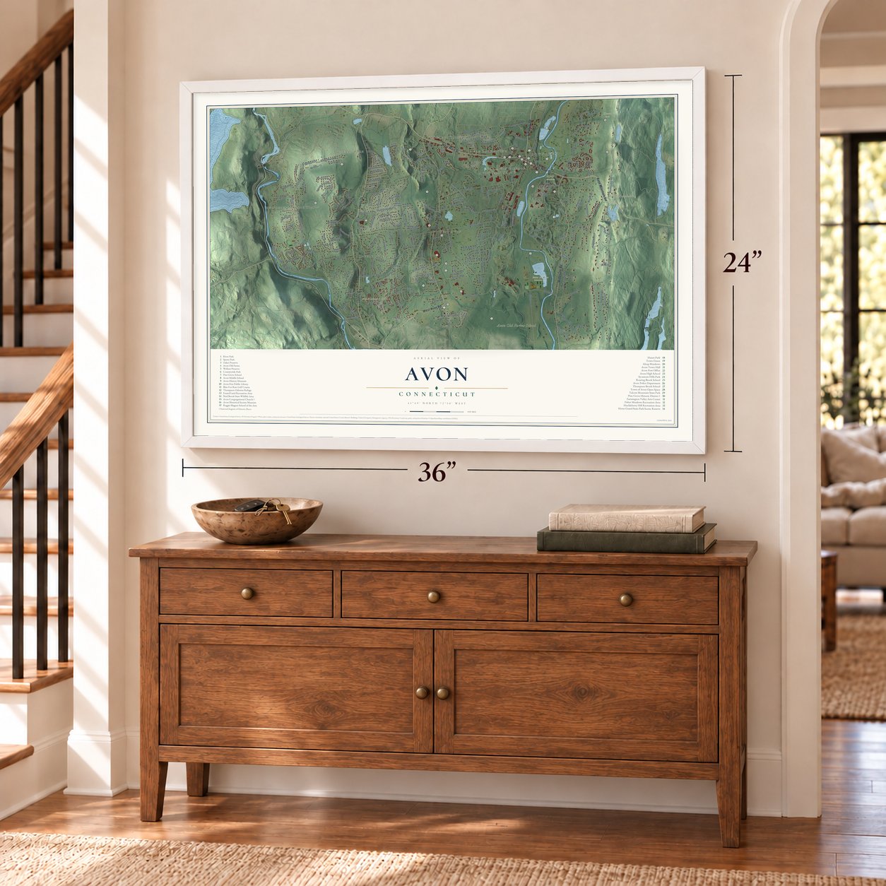
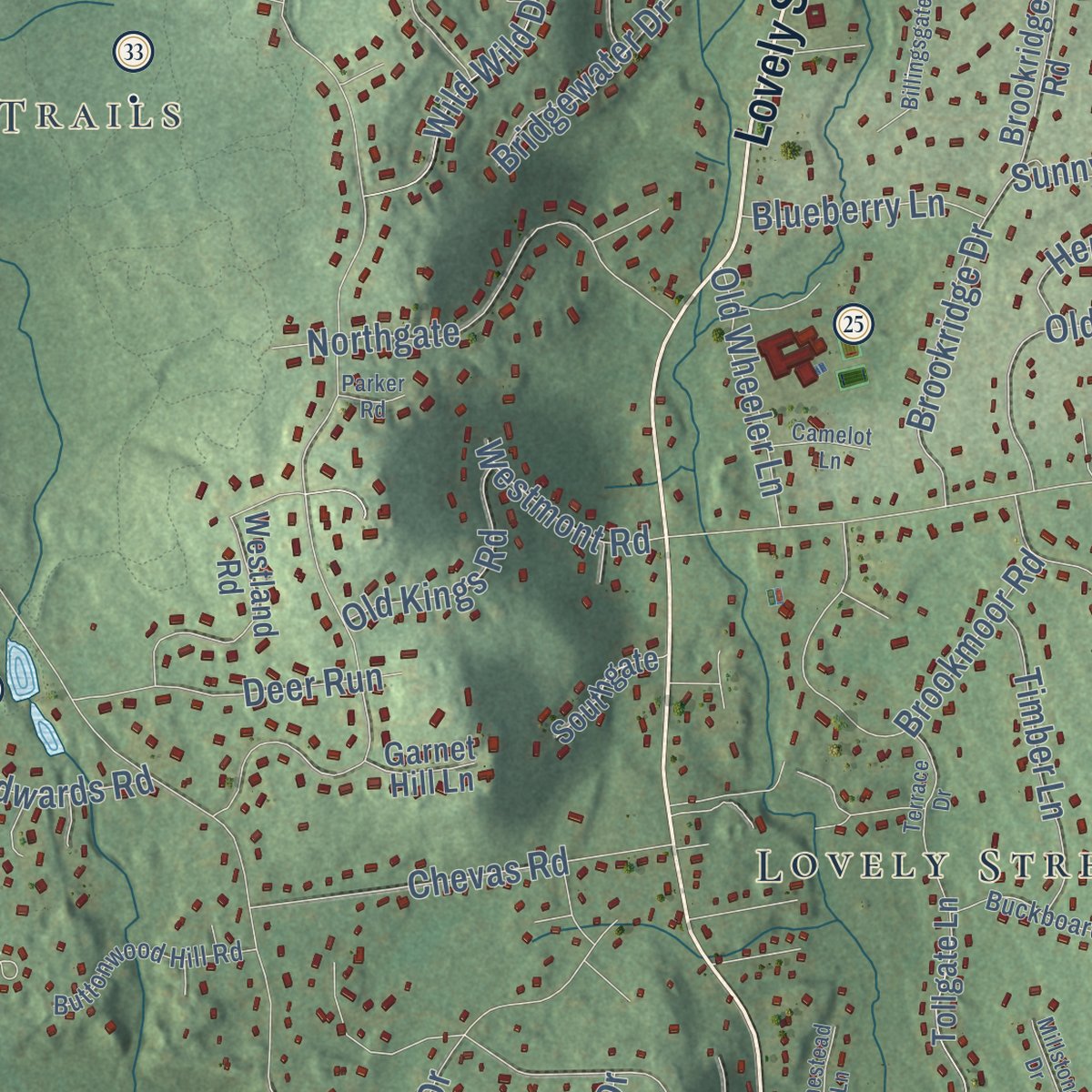
Explore Avon, Connecticut from a whole new perspective. Created using aerial imagery and detailed geographic data, this map captures Avon building by building, with labeled streets, familiar landmarks, and shaded topographical relief that highlights the natural contours of the landscape.
Combining modern data with the timeless character of a vintage atlas, this map is just as interesting up close as it is beautiful on the wall. Whether you grew up in Avon, spent memorable years there, or call it home today, this unique map is a great way to celebrate a place that means something to you. Zoom in on the preview to look for your street, and then order a print to put your memories on the wall.

Three ways to hang it
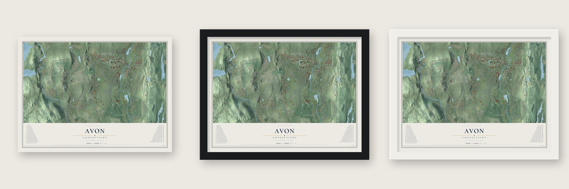
Unframed archival matte, a black wood frame or a white wood frame.
Up close
Geography Worth Displaying
This map was created using accurate cartographic data and authoritative geographic sources, including the U.S. Geological Survey (USGS) and FEMA. The map brings together terrain, waterways, roads, and building detail. The majority of the streets are labeled, houses are accurately depicted, and the topography is derived from government sources. Combining local data with carefully composed color and shading leads to this beautifully detailed Avon artwork for your wall.
Rather than simply showing street outlines, we’ve included as many of the street names as we could reasonably fit on the map while keeping their names legible. Zoom in on the high resolution preview to see exactly what’s on the map. We truly set out to create a statement piece for anyone who loves Avon. So whether it’s for you, or a gift for someone you love, we hope this map of Avon brings back fond memories.
Explore the full map of Avon, Connecticut and read about the local places it shows.

Find your street
Names on the Avon map
Every name below is printed on this map. Look for your street, your school, the park where you played, or the pond down the road.
Places and landmarks17
- Downtown
- Alsop Corner
- Huckleberry Hills Trails
- Old Avon Village
- Avon Park North
- Cherry Park
- Avon Mountain
- Ely Mound
- Huckleberry Hill
- Avon Old Farms School
- Alsop Meadows
- Fisher Meadows Recreation Area
Show all 17 places
- Hazen Park
- West Avon
- Crowleys Corner
- Lovely Street
- Avon Park South
Streets and roads232
- East Main Street
- West Main Street
- Avon Mountain Road
- Simsbury Road
- West Avon Road
- Waterville Road
- Gatewood
- Kingswood Drive
- Arch Road
- Woodmont Road
- Windsor Court
- Arlington Drive
- Oakridge Drive
- Old Farms Road
- Huckleberry Hill Road
- New Road
- Country Club Road
- Deercliff Road
- Northington Drive
- Byron Drive
- Hollister Drive
- Montevideo Road
- Burnham Road
- Nod Road
- Haynes Road
- Hollister Drive West
- Bayberry Hill Road
- Scoville Road
- Thompson Road
- Stagecoach Road
Show all 232 streets
- Juniper Drive
- Reverknolls
- Tillotson Road
- Cold Spring Road
- Pond Place
- Vermillion Drive
- Woodford Hills Drive
- Carriage Drive
- Kings Wood Drive
- Winding Lane
- Ayrshire Lane
- Anvil Drive
- Tamara Circle
- Mallard Drive
- Craigemore Circle
- Wright Drive
- Cider Brook Road
- Old Mill Road
- Climax Road
- Parkview Drive
- Woodhaven Drive
- Brookmoor Road
- Northgate
- Wellington Heights Road
- Rosewood Road
- Heritage Drive
- Wild Wild Drive
- Fox Den Road
- Moravia Road
- Chevas Road
- Lofgren Road
- Ridgecrest Lane
- Cotswold Way
- Pine Hill Road
- Avonridge
- Somerset Drive
- Forge Drive
- Meadow Ridge
- Sepous Road
- Oak Bluff
- Bishop Lane
- Wheeler Road
- Bridgewater Drive
- Bronson Road
- Brookridge Drive
- Tyler Court
- Secret Lake Road
- Beverly Drive
- Harris Road
- Fairway Ridge
- Deer Run
- Daventry Hill Road
- Westbury
- Fenwick Drive
- Timber Lane
- Sylvan Street
- School Street
- Knollwood Lane
- Stony Cors
- Kingsbridge
- Helena Road
- Henley Way
- Richard Street
- Sunnyridge Road
- Talcott Notch Road
- Weatherstone
- Stonefield Road
- Cheltenham Way
- Industrial Drive
- Nod Way
- Old Wheeler Lane
- Fisher Drive
- Old Kings Road
- Far Hills Drive
- High Gate Drive
- Brentwood Drive
- Lexington Road
- Blueberry Lane
- Sunrise Drive
- Old Wood Road
- Surrey Lane
- Breezy Knoll
- Brian Lane
- Riverview
- Deer Ridge Road
- Westmont Road
- Hitchcock Lane
- Stevens Street
- Orchard Street
- Dale Road
- Smith Road
- Edwards Road
- Cliff Drive
- Grant Drive
- Pioneer Drive
- Eddy Street
- Avalon Drive
- Park Road
- Hurdle Fence Drive
- Darling Drive
- Deepwood Drive
- Westland Road
- Catalpa Court
- North Farms Road
- Ensign Drive
- Oakengates
- Pheasant Run
- Tollgate Lane
- Briar Hill Road
- Spyglass Drive
- Sachem Trail
- Highwood Drive
- Hazen Drive
- Verville Road
- Sheffield Lane
- River Head Road
- Scarborough Drive
- Alcott Way
- Sconsett Bluff
- Rivermead
- Orchard Farms
- West Hills Drive
- Hastings Turn
- Ridgebury Road
- Cambridge Crossing
- Brookridge Road
- Mountain Estates Drive
- Oxbow Drive
- Quail Ridge
- Thistle Hollow
- Lakeview Boulevard
- Hillcrest Drive
- Poduny Trail
- Sky View Drive
- Fawn Run
- Ariel Way
- Avonside Knolls
- Southgate
- Monroe Lane
- Old Town Road
- Knoll Lane
- Hawley Hill Road
- Valley View Drive
- White Birch Lane
- Hemlock Lane
- Haber Drive
- Hickory Hill Road
- Crocus Lane
- Garnet Hill Lane
- Birch Road
- Day Road
- Diane Drive
- Alder Lane
- Frandel Drive
- Chidsey Road
- Buckingham Road
- Highridge Road
- Paper Chase Trail
- Security Drive
- Coventry Lane
- Lenox Road
- Buttonwood Hill Road
- Henderson Drive
- Foxcroft Run
- Buckboard Lane
- Pine Tree Lane
- Indian Pipe Trail
- Longview Road
- Saw Mill Lane
- Bailey Road
- Vista Terrace
- Woodland Drive
- Stillbrook Road
- Sudbury Way
- Delbon Lane
- Manion Lane
- Terry's Ridge
- Stony Corners Circle
- Lawrence Avenue
- Brocklesby Road
- Nottingham Ridge
- Billingsgate
- Applewood Lane
- Copplestone Road
- Saddle Ridge Drive
- Terrace Drive
- Rockledge Drive
- Princeton Drive
- Bolleswood Lane
- Cherry Tree Lane
- Homestead Lane
- Millstone Drive
- Brian Woods Drive
- Camelot Lane
- Sycamore Hills Road
- Biltmore
- Canal Court
- Holly Lane
- Parker Road
- Curtis Lane
- Bridal Path
- Jay Court
Names are listed as they appear on the printed map. Zoom into the product photos to find them.
About Avon, Connecticut
Avon is a town of 18,932 people in Hartford County, in the Farmington Valley below Talcott Mountain. Europeans settled here in 1645, when this ground was the northern end of Farmington. In 1750 the families up north won a parish of their own, called Northington, so they could worship at a church closer to home, and their first pastor, Ebenezer Booge, arrived in 1751.
In 1828 the Farmington Canal, dug from New Haven toward Northampton, reached East Avon at the spot where it met the turnpike from Hartford to Albany. Francis Woodford opened a three-story hotel by the crossing in 1830, and the village soon had three hotels along with harness, carriage and blacksmith shops. That same year the Connecticut General Assembly made Northington the town of Avon, named for County Avon in England. Within a few years the canal failed and the railroads drew the traffic away, so the growth Avon hoped for never arrived.
“It was at this time of stir and hopefulness in the community that the prominent men moved successfully for the incorporation of the town.”
- A camp 12,400 years oldAround 12,400 years ago, as the last Ice Age ended, nomadic people set up camp along the Farmington River. They were some of the earliest people to live in southern New England. Later groups came back to the spot again and again until floods buried it under river sediment. The camp was excavated in Avon in the winter of 2019, with stone tools made from materials carried in from neighboring regions.
- A church split 44 to 37In May 1817 Northington annexed the new Lovely Street and Whortleberry Hill lots, shifting people west. That December the old riverside meetinghouse burned; people suspected arson, an 1886 history says. In 1818 West Avon won the new church, 44 votes to 37, and the losers formed an East Avon society. They parted kindly, raising over $15,000 within a year. David Hoadley's 1819 meetinghouse, now Avon Congregational Church, joined the National Register in 1972.
- Safety fuse and tobaccoAlbert Franklin Andrews, born in Avon in 1824, started making safety fuse here in 1852 with his father Romeo and brother, running machines for his own invention, the Endless Safety Fuse. By 1902 the firm, now the Climax Fuse Company, was Avon's chief industry; it later merged with Simsbury's fuse makers. Chester R. Woodford, who bought the Webster farm in 1841, was Avon's first tobacco grower; he also helped found the Avon Creamery and was its president.
- Towers on Talcott MountainDaniel Wadsworth of Hartford built his first tower on Talcott Mountain in 1810 and a second one in 1840. Wind brought down one and fire destroyed the other, and in 1867 Bartlett's Tower went up on the highest point of the ridge. The ridge is now Talcott Mountain State Park.
- A library from 1791Avon's free public library dates back to 1791, 39 years before Avon became a town. In 1798 a resident turned his own home into the library, lending from a collection of 111 titles.
Keep exploring Connecticut
Avon is one of 382 Connecticut towns we've mapped. Every dot on the map is a print of its own.
The search covers every state, Connecticut first.
Near Avon
Order 2 or more town maps and save 10%. Shown in the size and finish you picked above, so they hang as a set.
- Canton Valley 12" x 18" / Archival Matte Print $39.99
- West District 12" x 18" / Archival Matte Print $39.99
- Farmington 12" x 18" / Archival Matte Print $39.99


More maps nearby: Weatogue, Collinsville, West Hartford, Tootin' Hills and Burlington.
The art of mapping a place
How This Map Was Made
Real places. Remarkable detail. Discover the layers that turn geographic data into a map of home.

The view from above
Aerial imagery reveals the character of the land: woodland, open fields, and the patterns of a place.

The shape of the land
Elevation data brings hills, valleys, and subtle changes in the landscape into view.

The details of home
Roads, waterways, and building footprints come together to make the map feel unmistakably local.

Geography becomes art
Considered color, shading, and typography bring the layers together in a map made for your wall.


Process illustrated with Mendon, Massachusetts. Aerial imagery: USDA NAIP. Terrain: USGS 3D Elevation Program. Map details and finished artwork: KNOWOL.
The Details
About This Print
Choose an archival matte print, or a black or white Ayous wood frame. The archival matte print is unframed.
Select your size and finish above to see the matching product image and price.
Materials & Craftsmanship
A contemporary map with the character of a classic atlas, printed on archival matte paper. Optional frames are made from Ayous wood.
Your printed map does not include the watermark shown in the full-map preview.
Shipping & Delivery
Free shipping within the United States. Every print is made to order in the USA.
Buying a gift? Add a note in your cart and we'll include it. We never put prices in the package.
Prints ship within 2 to 3 business days. Allow 7 to 10 days total from ordering for delivery. Timing may vary during holidays or periods of high order volume.
Read our shipping policy.
Returns and damaged prints
Each print is made to order. Change-of-mind refunds are not available after production.
If your print arrives damaged, misprinted or incorrect, contact support@knowol.com within 30 days of receiving it. Include your order number, photos and a description of the issue.
Read our full refund and replacement policy. For questions about your order, email support@knowol.com.