


Search for another town


Free U.S. delivery 7 to 10 days after you order
Brentwood, California Map Art
Building by building, with labeled streets and shaded relief.
12" x 18" Archival Matte Print
A Map of Home. A Work of Art.
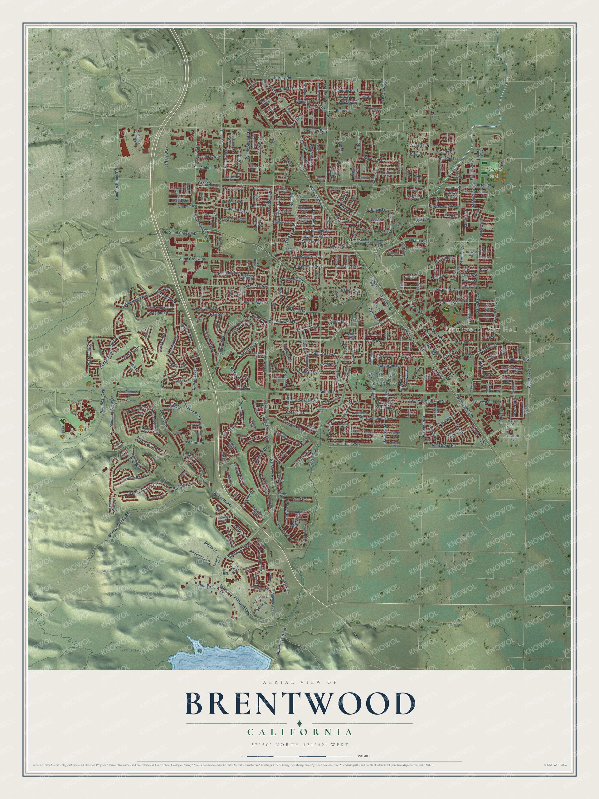
Explore Brentwood, California from a whole new perspective. Created using aerial imagery and detailed geographic data, this map captures Brentwood building by building, with labeled streets, familiar landmarks, and shaded topographical relief that highlights the natural contours of the landscape.
Combining modern data with the timeless character of a vintage atlas, this map is just as interesting up close as it is beautiful on the wall. Whether you grew up in Brentwood, spent memorable years there, or call it home today, this unique map is a great way to celebrate a place that means something to you. Zoom in on the preview to look for your street, and then order a print to put your memories on the wall.
Three ways to hang it

Unframed archival matte, a black wood frame or a white wood frame.
Up close
Geography Worth Displaying
This map was created using accurate cartographic data and authoritative geographic sources, including the U.S. Geological Survey and the Census Bureau. The map brings together terrain, waterways, roads, and building detail. The majority of the streets are labeled, houses are accurately depicted, and the topography is derived from government sources. Combining local data with carefully composed color and shading leads to this beautifully detailed Brentwood artwork for your wall.
Rather than simply showing street outlines, we’ve included as many of the street names as we could reasonably fit on the map while keeping their names legible. Zoom in on the high resolution preview to see exactly what’s on the map. We truly set out to create a statement piece for anyone who loves Brentwood. So whether it’s for you, or a gift for someone you love, we hope this map of Brentwood brings back fond memories.
Read the story behind this map of Brentwood, California from 2026.

Find your street
Names on the Brentwood map
Every name below is printed on this map. Look for your street, your school, the park where you played, or the pond down the road.
Places and landmarks3
- Brentwood City Hall
- Arbor
- Sunset Park
Streets and roads429
- Central Boulevard
- Walnut Boulevard
- Grant Street
- Walking Path
- Curtis Drive
- Sand Creek Road
- Solera Street
- Regal Drive
- Dawnview Drive
- Lone Tree Way
- Sunset Road
- Montecito Drive
- Mendota Street
- Birch Street
- San Jose Avenue
- Jeffery Way
- Amber Lane
- Lone Oak Road
- Fairview Avenue
- John Muir Parkway
- Highland Way
- Andalucia Lane
- Bedford Lane
- Rose Street
- Arlington Way
- Cobalt Lane
- Carmel Parkway
- Steeple Boulevard
- Balfour Road
- O'Hara Avenue
Show all 429 streets
- Brentwood Boulevard
- Garin Parkway
- Minnesota Avenue
- Saint Andrews Drive
- Concord Avenue
- Ohara Avenue
- Old Sand Creek Road
- Vineyard Parkway
- Shady Willow Lane
- Griffith Lane
- Neroly Road
- Apple Hill Drive
- Oak Street
- Foothill Drive
- Creek Road
- First Street
- Armstrong Road
- West Country Club Drive
- Empire Avenue
- Sellers Avenue
- Heidorn Ranch Road
- Lakeview Drive
- Presidio Drive
- Continente Avenue
- Spyglass Drive
- Palmillia Drive
- Chestnut Street
- Dainty Avenue
- Sycamore Avenue
- Rutherford Circle
- Baldwin Drive
- Crescent Drive
- Bismarck Lane
- Briones Valley Road
- McClarren Road
- Spruce Street
- Regent Drive
- American Avenue
- Valley Green Drive
- Mountain View Drive
- Adams Lane
- Pebble Beach Drive
- Apricot Way
- Second Street
- Centennial Drive
- Spanish Bay Drive
- Saint Regis Avenue
- Vintage Circle
- Redhaven Street
- Stonewood Drive
- Putter Drive
- Chianti Lane
- 1 Street
- Marsh Creek Road
- Atherton Boulevard
- Miwok Avenue
- Pippo Avenue
- Anderson Lane
- Summerset Drive
- Anastasia Drive
- Guthrie Lane
- Carnegie Lane
- Central Park Place
- Mills Drive
- Chamomile Lane
- Windy Springs Lane
- Country Glen Lane
- Stewart Way
- Demartini Lane
- Kent Drive
- Roundhill Drive
- Castellina Drive
- Berkshire Lane
- Armstrong Way
- Big Basin Drive
- Waterville Drive
- Latour Avenue
- Meadow Brook Drive
- Pomona Drive
- Jubilee Drive
- Franklin Drive
- Milford Street
- Elkins Way
- Winesap Drive
- Breakwater Way
- California Trail
- Randy Way
- Michael Way
- Prominent Drive
- Summerwood Drive
- Bacchini Lane
- Cortona Way
- Garland Way
- Harvest Park Drive
- Ventura Drive
- Richardson Drive
- Europena Drive
- Zinfandel Drive
- Brighton Drive
- Eileen Street
- Vivian Street
- Havenwood Avenue
- Salice Way
- Bonnie Lane
- Hanson Lane
- Rosegate Avenue
- Suntan Lane
- Burghley Lane
- Myrtle Beach Drive
- Wayne Drive
- Brookdale Drive
- Fawnbrook
- Village Drive
- Alta Street
- Fletcher Lane
- La Pergola Drive
- Persimmon Drive
- Gann Street
- Henry Hart Drive
- Gold Poppy Street
- Sunrise Drive
- Buena Vista Street
- Blumen Avenue
- Guise Way
- Twain Way
- Gracie Lane
- Woodside Drive
- Iron Club Drive
- Glenwillow Drive
- Newton Drive
- Date Nut Street
- Beverly Place
- Bamboo Drive
- Smith Road
- Carlisle Drive
- Sarah Street
- Yardley Place
- Rockwell Street
- Woodfield Lane
- Pippin Drive
- Rossano Street
- Caraway Drive
- Larkspur Lane
- Buckeye Court
- Ash Court
- Poppy Court
- Tilton Lane
- Rice Street
- Kayla Place
- Benoni Lane
- Gregory Lane
- Antica Drive
- Cabada Drive
- Bond Lane
- Ray Court
- Pecan Place
- Brandy Street
- Pasco Drive
- Dill Drive
- Laird Place
- Ray Street
- Mint Drive
- Effie Court
- Ash Street
- Iris Court
- Fir Street
- Berry Lane
- Ann Street
- Alloro Drive
- Gladstone Drive
- Rainer Street
- Sunflower Lane
- Pescara Boulevard
- Panorama Way
- Diablo Way
- Reserve Drive
- Torrey Pines Drive
- Upton Pyne Drive
- Hudson Drive
- Marina Way
- Eagle Rock Avenue
- Gamay Way
- Saint Augustine Drive
- Fremont Peak Drive
- Orchid Drive
- Rosie Lane
- Barbaresco Lane
- Bus Center Drive
- Ranchwood Drive
- Roper Circle
- Stephens Drive
- Coventry Circle
- Wildrose Way
- Saint Michaels Way
- Wintergreen Drive
- Baird Circle
- Nunn Street
- Sherwood Drive
- Canada Valley Road
- San Marino Drive
- Princess Way
- Saint Julien Street
- Peachwillow Drive
- San Juan Oaks Road
- Empire Road
- Yelland Way
- Bountiful Way
- Pondlilly Lane
- Hickory Drive
- Chaucer Drive
- Anderson Avenue
- Centennial Place
- Windsor Way
- Portofino Drive
- Veneto Lane
- Sage Sparrow Street
- Wright Way
- Jonagold Way
- Boulder Street
- Bridgewater Drive
- Sweetgrass Drive
- Exeter Way
- Tayberry Way
- Rioja Way
- Gala Lane
- Pearl Way
- Toulouse Lane
- Clearview Drive
- Blue Ridge Avenue
- Blossom Drive
- Pacific Grove Court
- Ironwood Drive
- Hanover Street
- Century Oaks Drive
- Hamilton Street
- Mojave Drive
- Star Lilly Street
- Tarragon Drive
- Giotto Drive
- Sofia Way
- Breton Drive
- Trailside Drive
- French Drive
- Bella Drive
- Saddle Creek Court
- Liberty Lane
- Montclair Place
- Douglas Drive
- Finn Way
- Caper Drive
- Lillian Street
- Boone Drive
- Lone Oak Court
- Wildcat Lane
- Fiano Lane
- Hedge Avenue
- Cashew Place
- Walsh Street
- Auburn Street
- Kenwood Drive
- Cayenne Drive
- Sequoia Street
- Waldon Street
- Bel Air Court
- Water Street
- Trinity Place
- Whitby Lane
- Malaga Way
- Troon Drive
- Dean Court
- Ellen Lane
- Caddie Court
- Brooks Street
- George Court
- Baja Court
- Linden Street
- Iparq Way
- Duffy Way
- Wolfe Road
- Pippo Place
- Craig Court
- Tulare Street
- Avery Court
- Elm Street
- Topaz Street
- Prato Street
- Loring Way
- Anjou Parkway
- East Country Club Drive
- Crispin Drive
- Wildflower Loop
- Dynasty Drive
- Trilogy Parkway
- Grovewood Loop
- Saint Edmunds Way
- Tempranillo Lane
- Mandevilla Drive
- Symphony Circle
- Red Rome Lane
- Woodsong Lane
- Begonia Drive
- Revenna Way
- Hallmark Way
- La Costa Drive
- Fitzgerald Way
- Brookshire Street
- Frascati Way
- Arezzo Street
- Sheldon Drive
- Brandon Miles Way
- Clarksburg Place
- Armstong Way
- Bismarck Terrace
- Jefferson Drive
- Dunedin Drive
- Amberleaf Way
- Belmont Avenue
- Provence Lane
- Marigold Drive
- Susan Street
- Carter Place
- Camden Court
- Mildred Avenue
- Country Court
- Monarch Terrace
- Nassau Lane
- Oxford Lane
- Desert Gold Terrace
- White Sands Street
- Thornhill Lane
- Poe Court
- Piva Court
- Arch Court
- Trinity Drive
- Oakville Court
- Fairview Court
- Cashew Court
- Holly Court
- Victoria Drive
- Orchid Court
- Capital Drive
- Lee Way
- Quail Court
- Kent Place
- Sand Creek Drive
- Ghiggeri Drive
- Comice Parkway
- Outrigger Circle
- Claremont Drive
- Corte Vista Street
- Nottingham Drive
- Homecoming Way
- Pheasant Run Terrace
- Medallion Drive
- Amanda Circle
- Camelback Road
- Cristina Way
- Tachella Way
- Edgefield Street
- Stanwick Street
- Pioneer Square
- Brushwood Place
- Altessa Drive
- Orchard Drive
- North Estates Drive
- Pomerol Circle
- Cambrian Place
- Los Colinas Drive
- Pearson Drive
- Sassafras Drive
- Crawford Drive
- Alexander Way
- Augusta Drive
- Atterbury Lane
- Spartan Terrace
- Technology Way
- Rubidoux Terrace
- Huntington Way
- Paradise Lane
- Thomas Road
- Villa Terrace
- Bramhall Street
- Beatrice Street
- Darby Drive
- Blue Oak Court
- Larkspur Court
- Natwick Way
- Bristol Court
- Sienna Lane
- Brampton Place
- Caddie Lane
- Lavender Drive
- Nicholas Court
- Maggiore Court
- Arroyo Seco Road
- Lincoln Avenue
- Cellini Terrace
- Emory Oak Court
- Sims Road
Names are listed as they appear on the printed map. Zoom into the product photos to find them.
About Brentwood, California
Brentwood is a city of 64,292 people in Contra Costa County, at the edge of the Sacramento-San Joaquin Delta. The Julpun, a Bay Miwok people, lived here first. In 1837 John Marsh got Rancho Los Méganos, the land grant under today's city, from Jose Noriega. Marsh wrote letters praising California as farm country, and Eastern newspapers printed them. They drew the first wagon trains west. Marsh let the newcomers stay on his ranch while they settled, so his rancho became the end of the California Trail.
The town was later laid out on land given from Marsh's property. It was named for Marsh's ancestral home, Brentwood in Essex, England. A post office opened in 1878. In 1879 the Tulare & San Pablo Railroad was finished, with stations at Antioch, Brentwood and Byron. Brentwood became a city in 1948 and started its own police department that same year.
- The Julpun and the missionThe Julpun built villages along creeks full of fish, and they held the peaks of Mt. Diablo sacred as the birthplace of the world. A few moved to Mission San Jose between 1806 and 1808, and about 100 had gone by 1813. By 1819, 141 had been baptized there. After the mission was turned into a secular institution, the Julpun left in 1836 and went back to their old land. Many may have worked for John Marsh there.
- The Brentwood Hotel of 1910Balfour, Guthrie & Co., a British investment firm, bought the Marsh ranch in 1910. The same year the firm put up the Brentwood Hotel facing the railroad station, on the corner of Oak Street and Brentwood Boulevard. An earlier hotel on that site had burned in 1903. The hotel came down in 1967 to make room for a service station. Its Mission style later inspired the new City Hall, which was begun in November 2009 and finished in May 2012.
- Cherries, corn and peachesBay Area shoppers still know Brentwood for its cherries, corn and peaches. Since 1990 many old farms and orchards have become housing, but the Contra Costa County Agricultural Core still borders the city on three sides. It holds 11,000 acres of protected farmland that is still worked.
Keep exploring California
Brentwood is one of 1,990 California towns we've mapped. Every dot on the map is a print of its own.
The search covers every state, California first.
Near Brentwood
Order 2 or more town maps and save 10%. Shown in the size and finish you picked above, so they hang as a set.
- Knightsen 12" x 18" / Archival Matte Print $39.99
- Oakley 12" x 18" / Archival Matte Print $39.99
- Antioch 12" x 18" / Archival Matte Print $39.99


More maps nearby: Byron, Discovery Bay, Bethel Island, Pittsburg and Clayton.
The art of mapping a place
How This Map Was Made
Real places. Remarkable detail. Discover the layers that turn geographic data into a map of home.

The view from above
Aerial imagery reveals the character of the land: woodland, open fields, and the patterns of a place.

The shape of the land
Elevation data brings hills, valleys, and subtle changes in the landscape into view.

The details of home
Roads, waterways, and building footprints come together to make the map feel unmistakably local.

Geography becomes art
Considered color, shading, and typography bring the layers together in a map made for your wall.


Process illustrated with Mendon, Massachusetts. Aerial imagery: USDA NAIP. Terrain: USGS 3D Elevation Program. Map details and finished artwork: KNOWOL.
The Details
About This Print
Choose an archival matte print, or a black or white Ayous wood frame. The archival matte print is unframed.
Select your size and finish above to see the matching product image and price.
Materials & Craftsmanship
A contemporary map with the character of a classic atlas, printed on archival matte paper. Optional frames are made from Ayous wood.
Your printed map does not include the watermark shown in the full-map preview.
Shipping & Delivery
Free shipping within the United States. Every print is made to order in the USA.
Buying a gift? Add a note in your cart and we'll include it. We never put prices in the package.
Prints ship within 2 to 3 business days. Allow 7 to 10 days total from ordering for delivery. Timing may vary during holidays or periods of high order volume.
Read our shipping policy.
Returns and damaged prints
Each print is made to order. Change-of-mind refunds are not available after production.
If your print arrives damaged, misprinted or incorrect, contact support@knowol.com within 30 days of receiving it. Include your order number, photos and a description of the issue.
Read our full refund and replacement policy. For questions about your order, email support@knowol.com.