
Search for another town


Free U.S. delivery 7 to 10 days after you order
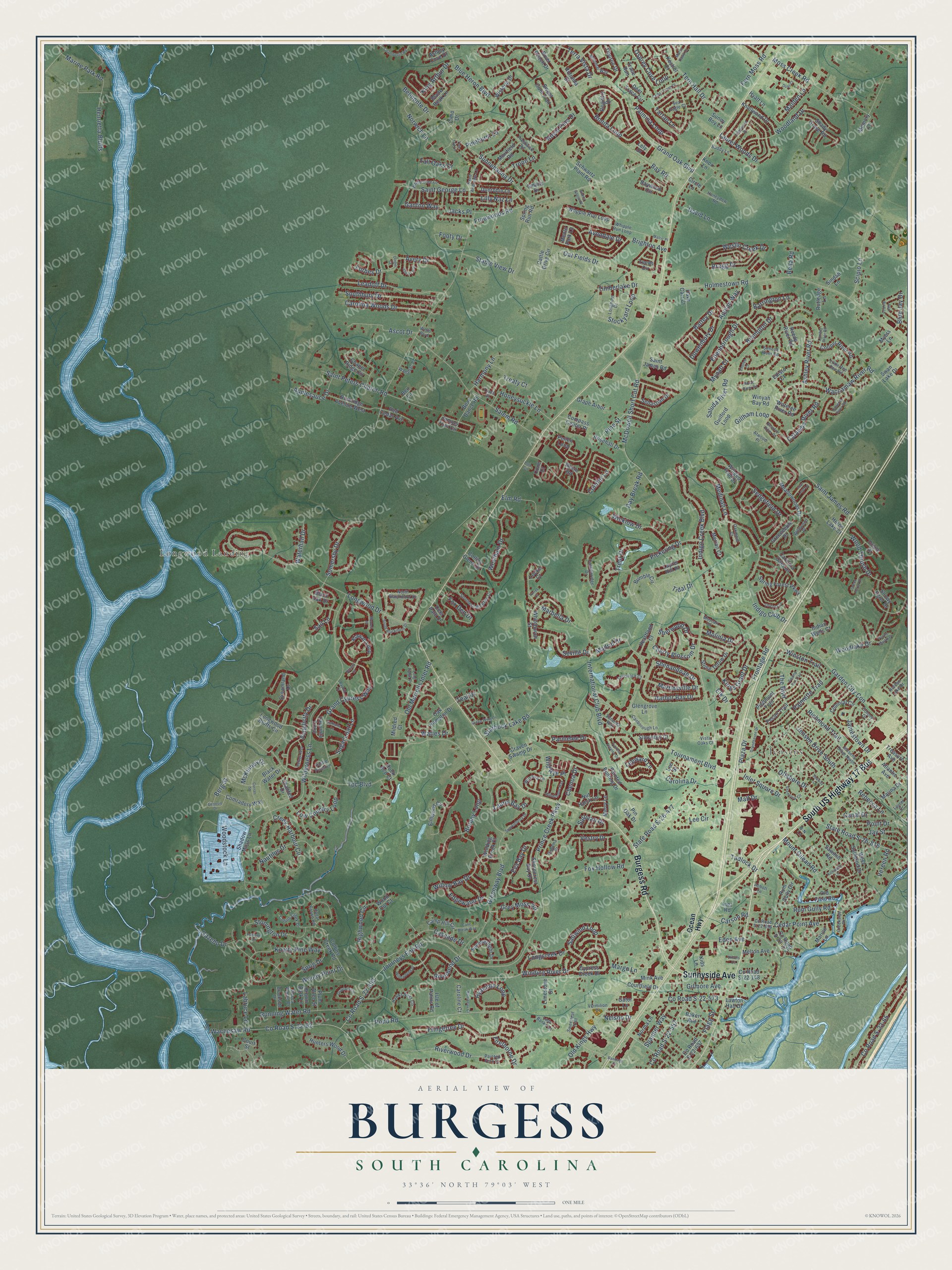
Burgess, South Carolina Map Art
Building by building, with labeled streets and shaded relief.
12" x 18" Archival Matte Print
A Map of Home. A Work of Art.
Explore Burgess, South Carolina from a whole new perspective. Created using aerial imagery and detailed geographic data, this map captures Burgess building by building, with labeled streets, familiar landmarks, and shaded topographical relief that highlights the natural contours of the landscape.
Combining modern data with the timeless character of a vintage atlas, this map is just as interesting up close as it is beautiful on the wall. Whether you grew up in Burgess, spent memorable years there, or call it home today, this unique map is a great way to celebrate a place that means something to you. Zoom in on the preview to look for your street, and then order a print to put your memories on the wall.
Three ways to hang it

Unframed archival matte, a black wood frame or a white wood frame.
Up close
Geography Worth Displaying
This map was created using accurate cartographic data and authoritative geographic sources, including the U.S. Geological Survey and the Census Bureau. The map brings together terrain, waterways, roads, and building detail. The majority of the streets are labeled, houses are accurately depicted, and the topography is derived from government sources. Combining local data with carefully composed color and shading leads to this beautifully detailed Burgess artwork for your wall.
Rather than simply showing street outlines, we’ve included as many of the street names as we could reasonably fit on the map while keeping their names legible. Zoom in on the high resolution preview to see exactly what’s on the map. We truly set out to create a statement piece for anyone who loves Burgess. So whether it’s for you, or a gift for someone you love, we hope this map of Burgess brings back fond memories.
Read the story behind this map: Detailed Map of Burgess, South Carolina.

Find your street
Names on the Burgess map
Every name below is printed on this map. Look for your street, your school, the park where you played, or the pond down the road.
Places and landmarks2
- Longwood Landing
- Jensens
Streets and roads416
- South US Highway 17 Bus
- Burgess Road
- Sunnyside Avenue
- Highwood Circle
- Winding River Drive
- Low Country Loop
- Grey Moss Road
- Plaza Drive
- Carolina Drive
- The Boulevard
- Palmetto Trail
- McDowell Short Cut Road
- State Road S-26-477
- Freewoods Road
- Wilderness Lane
- Pond Road
- Riverwood Drive
- Frontage Road
- Pickering Drive
- Longwood Drive
- Prince Creek Parkway
- Holmestown Road
- Tpc Boulevard
- Tournament Boulevard
- Grand Cypress Way
- Waccamaw River Road
- Old Kings Highway
- Bay Road
- Greenway Boulevard
- Offshore Drive
Show all 416 streets
- Indigo Creek Boulevard
- Fringetree Drive
- County Road S-22-62
- Wachesaw Road
- Saluda River Road
- Mall Drive
- Indigo Club Drive
- Grand Oak Boulevard
- Conifer Lane
- Blue Heron Boulevard
- Garden City Con
- Salem Road
- Moss Creek Road
- County Road S-22-392
- Journeys End Road
- Bonita Loop
- Sedgefield Drive
- Oat Fields Drive
- Brighton Avenue
- Creek Harbour Circle
- Knotty Pine Way
- Woody Point Drive
- International Club Boulevard
- Sunnehanna Drive
- Kings Grant Drive
- Firethorne Drive
- Parmelee Drive
- Waties Drive
- Palmina Loop
- Rum Gully Road
- Point Drive
- Tartan Lane
- State Road S-26-816
- Woodland Drive
- Saint Peters Church Road
- Timberlake Drive
- Edenborough Drive
- Woodlake Drive
- Scipio Lane
- Henrietta Bluffs
- Royal Pine Drive
- County Road S-22-557
- Stonington Drive
- Leadoff Drive
- Southbury Drive
- Marbella Drive
- Tern Hall Drive
- County Road S-22-65
- Cherry Blossom Drive
- Ashley River Road
- Winston Trail
- Mount Gilead Road
- Wood Thrush Drive
- Running Water Road
- Starbuck Lake Road
- Weslin Creek Drive
- Applesauce Drive
- Stockyard Loop
- Inlet Square Drive
- Nautilus Drive
- Fox Den Drive
- Elm Road
- Botany Loop
- Saint George Lane
- Carolina Woods Drive
- Labruce Lane
- Avery Drive
- Lee Circle
- Saint James Road
- Old Murrells Inlet Road
- Osprey Cove Loop
- Leeward Lane
- Hyacinth Loop
- Cedar Point Avenue
- Belmonte Drive
- Jensen Drive South
- Simplicity Drive
- Cascade Drive
- Willow Bay Drive
- Fox Hollow Road
- County Road S-22-573
- Chenoa Drive
- Honeysuckle Lane
- Berg Street
- Laurel Woods Drive
- Somersby Drive
- Harbor Bay Drive
- Ascot Drive
- Westham Drive
- Battey Drive
- Seville Drive
- Harmony Lane
- Saltwind Loop
- Marine Park Road
- Lilly Naz Lane
- Norwich Lane
- Sugar Loaf Lane
- Footy Drive
- Gillham Loop
- Flagg Street
- Medinah Lane
- Shenandoah Drive
- Wicklow Drive
- Brampton Drive
- Richmond Trail
- Riverbend Drive
- Sullivan Drive
- Rebecca Lane
- Longcreek Drive
- Jamestown Drive
- Spanner Way
- David Lane
- Martinsville Drive
- Jay Street
- Bragg Drive
- Ganton Way
- Vestry Drive
- Mynatt Court
- Stable View Drive
- Tall Oaks Court
- Woodstock Lane
- Catawba River Road
- Pinehurst Lane
- Eden Avenue
- Edgewater Drive
- Sprig Drive
- Sherwood Drive
- Terra Vista Drive
- Elk Drive
- Fern Moss Road
- Dowenbury Drive
- Canal Drive
- Avondale Drive
- McKinney Drive
- Gilmore Avenue
- King Arthur Drive
- Blue Jay Drive
- Maiden Lane
- Jacks Place
- Wild Rye Place
- Eva Bay Drive
- Appian Way
- Laurel Bay Drive
- Molinia Drive
- Waterhall Drive
- Pine Street
- Carson Road
- Barrington Lane
- Day Break Road
- Trent Drive
- Tadlock Drive
- Troon Lane
- Sail Lane
- Nelson Drive
- Gazebo Drive
- Margo Lane
- Teal Drive
- Vereen Road
- Madrid Drive
- Tidal Drive
- Bella Road
- Forbes Drive
- Treaty Court
- Ocean Highway
- Pecan Trail
- Meadowoods Drive
- Cattle Drive Circle
- Summerlight Drive
- Whpple Run Loop
- Longwood Bluffs Circle
- Bumble Circle
- Chapel Ridge Circle
- Collins Creek Road
- Shadow Moss Lane
- Wisteria Drive
- Dreamland Drive
- Baywood Circle
- Cooper River Road
- Stone Throw Drive
- Cypress Creek Drive
- Deer Trace Circle
- Shorecrest Bay Drive
- Jumper Trail Circle
- Whitchurch Street
- Elmwood Circle
- Collins Glenn Drive
- Painted Bunting Drive
- Winged Foot Drive
- Leeds Circle
- Black Water Drive
- Kiawah Loop
- Burkridge Avenue West
- Reedy River Road
- County Road S-22-697
- Colonial Circle
- Schwartz Plant Road
- Pollen Loop
- Heron Lake Court
- Marina Drive
- Oak Hampton Drive
- Muirfield Road
- Comradery Way
- Wateree River Road
- Spring Forest Parkway
- Knollwood Drive
- Dunrobin Lane
- Hunters Wood Drive
- Shady Grove Road
- Old Field Road
- Isle of Palms Road
- Atlantic Avenue
- Guilford Loop
- Camp Hill Circle
- Tiburon Drive
- Craven Swamp Drive
- Laquinta Loop
- Circle Lane
- County Road S-22-272
- Sebastian Drive
- Indian Wells Court
- Smalls Drive
- Oriole Drive
- County Road S-22-148
- Bear Dance Road
- Swan Lake Drive
- Snowy Egret Drive
- West Surfwind Drive
- Rosehall Drive
- Heartland Court
- River Reach Drive
- Rum Gully Circle
- Blade Beak Lane
- Grape Arbor
- Compass Center Place
- Red Cedar Avenue
- Simonton Court
- Registry Drive
- Greeneedle Place
- Piedmont Trail
- Merion Court
- Merry Lane
- Sweet Gum Trail
- Resin Road
- Courtfield Drive
- Mink Avenue
- Caroline Court
- Nut Hatch Lane
- Norma Lane
- Melton Avenue
- Laurel Hill Place
- Treasure Avenue
- Winyah Bay Road
- Dave Carr Court
- Glengrove Lane
- Limestone Street
- Carolina Oaks Drive
- Black Oak Drive
- Ashley Cove Drive
- Brown Bark Lane
- Rutledge Lane
- Chanted Drive
- Plum Allee Street
- Sawmill Road
- Marion Lane
- Mildred Court
- Sunny Boy Lane
- Baker Avenue
- Winding Brook Court
- Hyatt Lane
- Kids Lane
- Court Street
- Memory Lane
- Rotunda Court
- Trace Run
- Kestrel Court
- Gator Lane
- Lee Street
- Sindab Lane
- Deer Path Drive
- Spring Run Road
- Menlo Park Lane
- Lawton Hall Drive
- Locke Court
- Pin Oak Drive
- Cimo Drive
- Myers Lane
- Wood Cut Court
- Edisto Court
- Rock Bed Court
- Knox Lane
- Lely Drive
- Inez Road
- Cone Court
- Ben Lane
- Saint Andrews Lane
- Southern Breezes Circle
- County Road S-22-656
- North Blackmoor Drive
- Hawks Nest Circle
- Hagar Brown Road
- Collins Creek Drive
- Colony Drive
- Tavistock Court
- Laurel Drive
- Castlebridge Drive
- Whipple Run Loop
- Hidden Lake Drive
- Veranda Way
- Jensens Drive North
- Wilshire Lane
- White Tree Lane
- Wacca Wache Drive
- Buddy Lane
- Miromar Way
- Canborough Lane
- Painted Fern Court
- Prestwick Road
- Longhorn Drive
- Honeydew Road
- Lady Banks Lane
- Bahama Drive
- Wanabac Place
- Brookside Drive
- Truce Street
- Creekside Drive
- Wildwood Place
- Seneca River Road
- Muscari Drive
- Sweetleaf Trail
- Little Pee Dee Road
- Castle Pines Lane
- Vermilion Drive
- Oakmont Court
- Sea Eagle Court
- Vista Oaks Court
- Atwood Place
- Abbott Lane
- Wells Boulevard
- B-N Lane
- Cypress Estates Drive
- Willowbend Drive
- Graytwig Circle
- Grandhaven Drive
- Four Leaf Lane
- Red Bird Lane
- Kittiwake Lane
- Wimbledon Way
- Curran Street
- Shamrock Circle
- Edgewood Drive
- South Blackmoor Drive
- Long Ridge Drive
- Purple Martin Drive
- Refuge Way
- Cedar Trace Drive
- Hatteras River Road
- Sparkleberry Drive
- Green Wing Drive
- Chamberlin Road
- Shea Loop
- Chicory Lane
- Beaufort River Drive
- Genesis Drive
- Murrell Place
- Tree Top Lane
- Lumber River Road
- Cane Break Way
- Swamp Fox Trail
- Seaway Lane
- Broad River Road
- Green Heron Drive
- Valhalla Lane
- Barrineau Court
- Bandage Court
- Marsh Hawk Drive
- Dinger Court
- Bayhill Court
- Emma Gause Place
- Malric Place
- Barlowe Court
- Nittany Court
- Duel Court
- Enoree Court
- Vinters Lane
- Turret Court
- Polo Circle
Names are listed as they appear on the printed map. Zoom into the product photos to find them.
About Burgess, South Carolina
Burgess was first called Marlow, after its first postmaster, John W. Marlow, appointed in 1880. William Burgess took over the post office in 1887. He had the name changed to Burgess in 1906. He stayed postmaster until his death in 1934.
Keep exploring South Carolina
Burgess is one of 540 South Carolina towns we've mapped. Every dot on the map is a print of its own.
The search covers every state, South Carolina first.
Near Burgess
Order 2 or more town maps and save 10%. Shown in the size and finish you picked above, so they hang as a set.
- Garden City 12" x 18" / Archival Matte Print $39.99
- Murrells Inlet 12" x 18" / Archival Matte Print $39.99
- Surfside Beach 12" x 18" / Archival Matte Print $39.99


More maps nearby: Bucksport, Lakewood, Socastee, Forestbrook and Plantersville.
The art of mapping a place
How This Map Was Made
Real places. Remarkable detail. Discover the layers that turn geographic data into a map of home.

The view from above
Aerial imagery reveals the character of the land: woodland, open fields, and the patterns of a place.

The shape of the land
Elevation data brings hills, valleys, and subtle changes in the landscape into view.

The details of home
Roads, waterways, and building footprints come together to make the map feel unmistakably local.

Geography becomes art
Considered color, shading, and typography bring the layers together in a map made for your wall.


Process illustrated with Mendon, Massachusetts. Aerial imagery: USDA NAIP. Terrain: USGS 3D Elevation Program. Map details and finished artwork: KNOWOL.
The Details
About This Print
Choose an archival matte print, or a black or white Ayous wood frame. The archival matte print is unframed.
Select your size and finish above to see the matching product image and price.
Materials & Craftsmanship
A contemporary map with the character of a classic atlas, printed on archival matte paper. Optional frames are made from Ayous wood.
Your printed map does not include the watermark shown in the full-map preview.
Shipping & Delivery
Free shipping within the United States. Every print is made to order in the USA.
Buying a gift? Add a note in your cart and we'll include it. We never put prices in the package.
Prints ship within 2 to 3 business days. Allow 7 to 10 days total from ordering for delivery. Timing may vary during holidays or periods of high order volume.
Read our shipping policy.
Returns and damaged prints
Each print is made to order. Change-of-mind refunds are not available after production.
If your print arrives damaged, misprinted or incorrect, contact support@knowol.com within 30 days of receiving it. Include your order number, photos and a description of the issue.
Read our full refund and replacement policy. For questions about your order, email support@knowol.com.