
Search for another town


Free U.S. delivery 7 to 10 days after you order
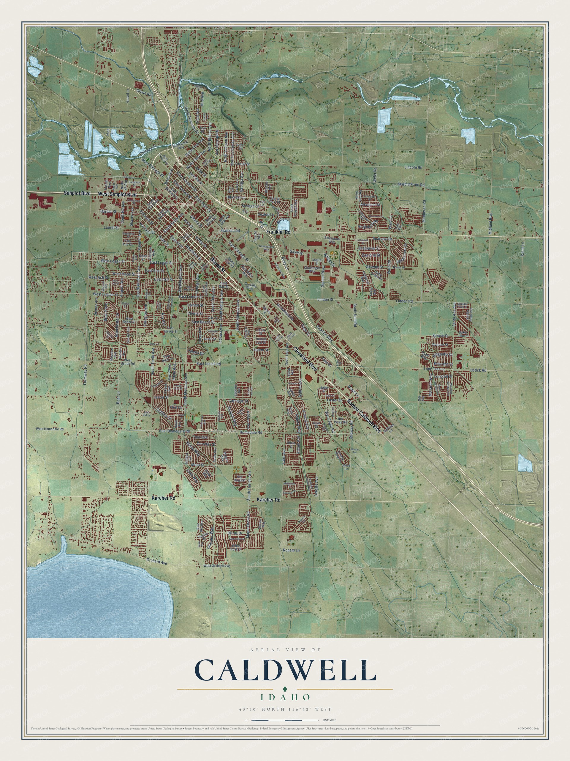
Caldwell, Idaho Map Art
Building by building, with labeled streets and shaded relief.
12" x 18" Archival Matte Print
A Map of Home. A Work of Art.
Explore Caldwell, Idaho from a whole new perspective. Created using aerial imagery and detailed geographic data, this map captures Caldwell building by building, with labeled streets, familiar landmarks, and shaded topographical relief that highlights the natural contours of the landscape.
Combining modern data with the timeless character of a vintage atlas, this map is just as interesting up close as it is beautiful on the wall. Whether you grew up in Caldwell, spent memorable years there, or call it home today, this unique map is a great way to celebrate a place that means something to you. Zoom in on the preview to look for your street, and then order a print to put your memories on the wall.
Three ways to hang it

Unframed archival matte, a black wood frame or a white wood frame.
Up close
Geography Worth Displaying
This map was created using accurate cartographic data and authoritative geographic sources, including the U.S. Geological Survey and the Census Bureau. The map brings together terrain, waterways, roads, and building detail. The majority of the streets are labeled, houses are accurately depicted, and the topography is derived from government sources. Combining local data with carefully composed color and shading leads to this beautifully detailed Caldwell artwork for your wall.
Rather than simply showing street outlines, we’ve included as many of the street names as we could reasonably fit on the map while keeping their names legible. Zoom in on the high resolution preview to see exactly what’s on the map. We truly set out to create a statement piece for anyone who loves Caldwell. So whether it’s for you, or a gift for someone you love, we hope this map of Caldwell brings back fond memories.
Read the story behind this map of Caldwell, Idaho from 2026.

Find your street
Names on the Caldwell map
Every name below is printed on this map. Look for your street, your school, the park where you played, or the pond down the road.
Places and landmarks3
- Caldwell City Hall
- Luby Park
- Underkoflers Corner
Streets and roads280
- Cleveland Boulevard
- Blaine Street
- West Simplot Boulevard
- Karcher Road
- Nampa-Caldwell Boulevard
- Simplot Boulevard
- Franklin Road
- South Kimball Avenue
- South Georgia Avenue
- East Freeport Street
- East Linden Street
- Boise Avenue
- East Homedale Road
- West Logan Street
- East Ustick Road
- Middleton Road
- Ustick Road
- Linden Street
- Ray Avenue
- Albany Street
- South Ninth Avenue
- West Hazel Street
- Roanoke Drive
- Carnegie Street
- Indiana Avenue
- South Indiana Avenue
- South Tenth Avenue
- South Montana Avenue
- South Florida Avenue
- Aviation Way
Show all 280 streets
- Homedale Road
- Marble Front Road
- Lincoln Road
- Farmway Road
- East Chicago Street
- Maple Grove Road
- Lake Avenue
- Midland Boulevard
- South Kcid Road
- Arthur Street
- Dearborn Street
- Everett Street
- North Illinois Avenue
- Spruce Street
- Airport Avenue
- Laster Street
- Cirrus Drive
- Midway Road
- Orchard Avenue
- East Beech Street
- Santa Ana Avenue
- Smeed Parkway
- Fillmore Street
- Washington Avenue
- Idaho Avenue
- East Ash Street
- College Avenue
- East Elgin Street
- Linden Road
- Lone Tree Lane
- Ward Road
- Cherry Street
- Arlington Avenue
- East Denver Street
- North Indiana Avenue
- Locust Street
- Moss Street
- Ward Lane
- Iowa Avenue
- Laster Lane
- Paynter Avenue
- South Ohio Avenue
- North Third Avenue
- Grant Street
- Chicago Street
- East Logan Street
- West Linden Street
- West Ash Street
- Laurel Street
- Manchester Drive
- Syringa Lane
- Georgia Avenue
- Hillcrest Lane
- Barkley Way
- Arrowhead Drive
- Garber Street
- Skyway Street
- North La Cresta Avenue
- Cumulus Way
- East Elm Street
- West Plymouth Street
- North First Avenue
- West Chicago Street
- Celeste Avenue
- War Eagle Road
- Bristol Avenue
- Asbury Way
- Andy Lane
- Bayou Way
- South Kit Avenue
- Hird Avenue
- Muller Lane
- Ormsby Avenue
- Knott Lane
- Ashton Avenue
- Rice Avenue
- Helena Drive
- Joliet Street
- Bear Lane
- Sage Drive
- Shelburne Street
- North Ohio Avenue
- Dietz Way
- Monarch Way
- Wilderness Drive
- Virginia Parkway
- Dragonfly Drive
- Altamont Street
- Ropers Lane
- Avalon Street
- Graye Lane
- Smeed Drive
- Carolina Street
- Settlers Street
- Longtail Drive
- Shaver Avenue
- Empress Street
- Harrison Street
- Green Road
- Cambria Street
- Abram Avenue
- Tara Avenue
- Friar Drive
- Skyway
- Wells Road
- Flint Drive
- Salem Street
- West Ustick Road
- Jump Creek Drive
- Pillar Rock Street
- Equinox Avenue
- Citrus Street
- Key West Street
- West Orchard Avenue
- Sunset Avenue
- Main Street
- East Oak Street
- East Belmont Street
- South Sixth Avenue
- Oregon Avenue
- West Homedale Road
- Oxbow Avenue
- Hannibal Street
- Polk Street
- Meadow Avenue
- Larch Street
- Fairview Avenue
- Griffiths Parkway
- South Lake Avenue
- Lincoln Street
- North 14th Avenue
- East Spruce Street
- Challenger Way
- Dorman Avenue
- Smiley Peak Avenue
- South Third Avenue
- West Beech Street
- Goldfinch Way
- Wallace Way
- Nez Perce Road
- Royal Way
- North Kcid Road
- Moss Lane
- North 16th Avenue
- Central Park Street
- London Park Place
- Layton Avenue
- Enterprise Way
- South Voyage Avenue
- Blue Sky Avenue
- Fractus Drive
- North Kit Avenue
- Centennial Way
- Palo Alto Drive
- Owyhee Lane
- East Ross Lane
- Hoffman Lane
- Roedel Avenue
- Sadie Avenue
- Madera Way
- Gravel Lane
- Red Robin Way
- Turning Leaf Street
- Conley Way
- Lolo Avenue
- Midvale Avenue
- Stock Trail Road
- Hawk Avenue
- Taft Street
- Capitol Street
- Jewel Way
- Mead Street
- Baker Lake Street
- Antigua Avenue
- Preston Avenue
- Specht Avenue
- Eaton Avenue
- Duke Street
- Pond Lane
- Alicia Street
- Muller Drive
- Silk Avenue
- Emily Avenue
- Julie Street
- Jay Lane
- West Freeport Street
- South Illinois Avenue
- Commercial Way
- Alder Street
- Marshall Avenue
- South 13th Avenue
- Mountain Springs Avenue
- Alaska Avenue
- Parker Avenue
- Industrial Way
- Colebrook Avenue
- Colfax Drive
- Meander Creek Way
- Signorello Street
- Crookham Street
- Worth Way
- Windsor Drive
- Parkhurst Drive
- Summers Street
- Skyway Drive
- Trailside Drive
- Felton Street
- Hill Lane
- Tidewater Street
- Princeton Avenue
- Loop Street
- Rodeo Avenue
- Millstone Street
- Boulder Peak Street
- Chance Street
- Colonial Drive
- Starlight Avenue
- Dynasty Avenue
- East Pat Lane
- Winn Avenue
- Crow Drive
- Kadie Street
- East Maple Street
- North Fifth Avenue
- North 21st Avenue
- South 18th Avenue
- South 20th Avenue
- Syringa Way
- West Oak Street
- Mesa Springs Avenue
- Fairoaks Drive
- Amber Street
- Hargrove Avenue
- South Willow Brook Place
- Johnson Lane
- Fieldcrest Drive
- Richmond Street
- Shoshoni Road
- Hilton Street
- Honey Crisp Drive
- Lansing Avenue
- South 43rd Avenue
- Aspen Falls Avenue
- Redrock Avenue
- Autumn Leaf Avenue
- South 41st Avenue
- Hanks Way
- Wilson Street
- Meeker Avenue
- Falcon Street
Names are listed as they appear on the printed map. Zoom into the product photos to find them.
About Caldwell, Idaho
Caldwell is a city of 59,996 people and the county seat of Canyon County, about 24 miles west of Boise. Long before the town, Native American tribes from as far away as Colorado gathered on the banks of the Boise River for yearly trading fairs. Later, emigrants on the Oregon Trail crossed the river near the spot where the Silver Bridge now carries Plymouth Street.
In 1883 Robert E. Strahorn came to the valley to choose a route for the Oregon Short Line Railroad. He judged the climb into Boise City too steep, so he picked a flat of sagebrush and greasewood 30 miles west and drove a stake there. The town was platted that August and named for his partner Alexander Caldwell, a former senator from Kansas. Settlers came so fast that within four months Caldwell had 600 residents in 150 homes. The new town also had two newspapers, a telephone exchange, a school and 40 businesses. Ada County's commissioners made it a city by a handwritten order on January 15, 1890.
- The College of IdahoThe Wood River Presbytery voted to place its Presbyterian college at Caldwell, and the College of Idaho opened here in 1891. It now sits on a 55-acre campus. John T. Morrison, one of its first teachers, later became governor of Idaho.
- Seat of Canyon CountyWhen Canyon County was carved out of Ada County, Caldwell became its county seat, and a brick and stone courthouse went up soon after. Irrigation canals turned the county into farm country. The Oregon Short Line joined the Union Pacific network, and Caldwell got a new freight and passenger depot in 1906.
- Indian Creek uncoveredIndian Creek runs through downtown, but it had been covered over and used by local industries to carry away sewage. In 2009 the city finished restoring it, adding suspended bridges, walkways and picnic tables. Indian Creek Plaza puts in an ice ribbon each winter.
Keep exploring Idaho
Caldwell is one of 279 Idaho towns we've mapped. Every dot on the map is a print of its own.
The search covers every state, Idaho first.
Near Caldwell
Order 2 or more town maps and save 10%. Shown in the size and finish you picked above, so they hang as a set.
- Middleton 12" x 18" / Archival Matte Print $39.99
- Nampa 12" x 18" / Archival Matte Print $39.99
- Notus 12" x 18" / Archival Matte Print $39.99


More maps nearby: Greenleaf, Star, Marsing, Wilder and Eagle.
The art of mapping a place
How This Map Was Made
Real places. Remarkable detail. Discover the layers that turn geographic data into a map of home.

The view from above
Aerial imagery reveals the character of the land: woodland, open fields, and the patterns of a place.

The shape of the land
Elevation data brings hills, valleys, and subtle changes in the landscape into view.

The details of home
Roads, waterways, and building footprints come together to make the map feel unmistakably local.

Geography becomes art
Considered color, shading, and typography bring the layers together in a map made for your wall.


Process illustrated with Mendon, Massachusetts. Aerial imagery: USDA NAIP. Terrain: USGS 3D Elevation Program. Map details and finished artwork: KNOWOL.
The Details
About This Print
Choose an archival matte print, or a black or white Ayous wood frame. The archival matte print is unframed.
Select your size and finish above to see the matching product image and price.
Materials & Craftsmanship
A contemporary map with the character of a classic atlas, printed on archival matte paper. Optional frames are made from Ayous wood.
Your printed map does not include the watermark shown in the full-map preview.
Shipping & Delivery
Free shipping within the United States. Every print is made to order in the USA.
Buying a gift? Add a note in your cart and we'll include it. We never put prices in the package.
Prints ship within 2 to 3 business days. Allow 7 to 10 days total from ordering for delivery. Timing may vary during holidays or periods of high order volume.
Read our shipping policy.
Returns and damaged prints
Each print is made to order. Change-of-mind refunds are not available after production.
If your print arrives damaged, misprinted or incorrect, contact support@knowol.com within 30 days of receiving it. Include your order number, photos and a description of the issue.
Read our full refund and replacement policy. For questions about your order, email support@knowol.com.