
Search for another town


Free U.S. delivery 7 to 10 days after you order
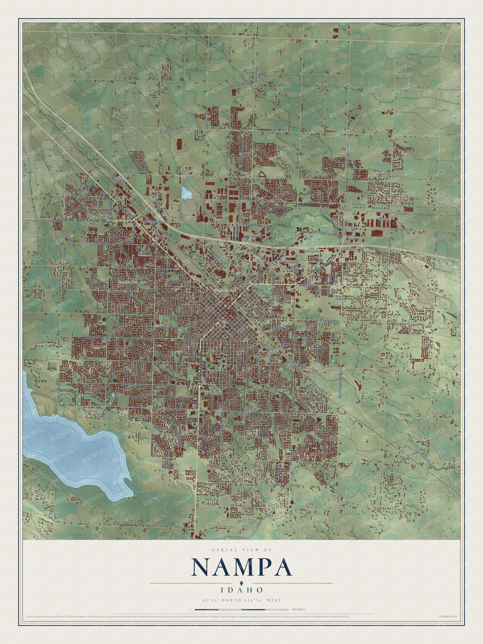
Nampa, Idaho Map Art
Building by building, with labeled streets and shaded relief.
12" x 18" Archival Matte Print
A Map of Home. A Work of Art.
Explore Nampa, Idaho from a whole new perspective. Created using aerial imagery and detailed geographic data, this map captures Nampa building by building, with labeled streets, familiar landmarks, and shaded topographical relief that highlights the natural contours of the landscape.
Combining modern data with the timeless character of a vintage atlas, this map is just as interesting up close as it is beautiful on the wall. Whether you grew up in Nampa, spent memorable years there, or call it home today, this unique map is a great way to celebrate a place that means something to you. Zoom in on the preview to look for your street, and then order a print to put your memories on the wall.
Three ways to hang it

Unframed archival matte, a black wood frame or a white wood frame.
Up close
Geography Worth Displaying
This map was created using accurate cartographic data and authoritative geographic sources, including the U.S. Geological Survey and the Census Bureau. The map brings together terrain, waterways, roads, and building detail. The majority of the streets are labeled, houses are accurately depicted, and the topography is derived from government sources. Combining local data with carefully composed color and shading leads to this beautifully detailed Nampa artwork for your wall.
Rather than simply showing street outlines, we’ve included as many of the street names as we could reasonably fit on the map while keeping their names legible. Zoom in on the high resolution preview to see exactly what’s on the map. We truly set out to create a statement piece for anyone who loves Nampa. So whether it’s for you, or a gift for someone you love, we hope this map of Nampa brings back fond memories.

Find your street
Names on the Nampa map
Every name below is printed on this map. Look for your street, your school, the park where you played, or the pond down the road.
Places and landmarks4
- Nampa City Hall
- Fischer
- Karcher Junction
- Rv Park
Streets and roads289
- Twelfth Avenue Road
- Garrity Boulevard
- Third Street South
- Caldwell Boulevard
- West Karcher Road
- Karcher Road
- North Midland Boulevard
- Nampa Boulevard
- East Franklin Road
- Ustick Road
- Can-Ada Road
- Eleventh Avenue South
- McDermott Road
- South Midland Boulevard
- East Victory Road
- High Street
- South Happy Valley Road
- Lake Lowell Avenue
- Midland Boulevard
- South Canyon Street
- Holly Street
- Eleventh Avenue North Extended
- West Roosevelt Avenue
- Franklin Boulevard
- Chicago Street
- Third Street North
- Cherry Lane
- Franklin Road
- Birch Lane
- East Amity Avenue
Show all 289 streets
- East Greenhurst Road
- Northside Boulevard
- East Railroad Street
- West Greenhurst Road
- Madison Road
- Lone Star Road
- Southside Boulevard
- Smith Avenue
- North Middleton Road
- Orchard Avenue
- South Middleton Road
- West Iowa Avenue
- East Locust Lane
- West Flamingo Avenue
- First Street South
- Midway Road
- East Sherman Avenue
- South Powerline Road
- West Blaine Avenue
- North Kings Road
- East Karcher Road
- Star Road
- Sunny Ridge Road
- South Juniper Street
- East Dewey Avenue
- West Railroad Street
- Sunnyridge Road
- Fifth Street South
- East Iowa Avenue
- North Sugar Avenue
- North Sugar Street
- Fern Street
- Ten Lane
- Ridgecrest Drive
- Fifth Street North
- Moss Lane
- Iowa Avenue
- East Roosevelt Avenue
- Davis Avenue
- South Grays Lane
- Airport Road
- Winther Boulevard
- First Street North
- South Midway Road
- South Kings Road
- Dooley Lane
- Madison Avenue
- Ivy Street
- Alma Lane
- Port Street
- South Valley Drive
- Industrial Road
- Maple Street
- Roosevelt Avenue
- North Armstead Avenue
- Blakeslee Drive
- West Buteo Drive
- Stonehedge Drive
- Stamm Lane
- Edgebrook Drive
- Queens Drive
- West Belknap Drive
- Sunflower Drive
- Sunny Lane
- North Cassia Street
- Sugar Cane Drive
- Fairway Drive
- Beniton Boulevard
- Wildflower Drive
- South Pine Street
- Linden Road
- Elm Lane
- Hudson Avenue
- Norco Way
- Barger Lane
- Banner Street
- Tayten Drive
- Aaron Drive
- Leo Drive
- Fall Drive
- York Avenue
- Fern Drive
- Can Ada Road
- North Franklin Boulevard
- Nevada Avenue
- West Orchard Avenue
- Central Southside Boulevard
- Second Street South
- Lone Tree Lane
- South State Street
- South Elder Street
- South Chestnut Street
- East Flamingo Avenue
- Blaine Avenue
- Sixth Street South
- North Midway Road
- Sixth Street North
- East Maine Avenue
- Greenhurst Road
- East Park Ridge Drive
- North 39th Street
- Dale Lane
- Sixth Street North Extended
- 14th Avenue South
- South Bonneville Drive
- South Taylor Street
- North 20th Street
- Karcher Bypass
- East Fargo Avenue
- Third Avenue North
- Prescott Lane
- West Kipling Way
- East Dooley Lane
- East Manowar Lane
- South Skyview Drive
- East Terra Linda Way
- South Raintree Drive
- Sugar Factory Road
- Discovery Place
- South Horton Street
- East Brooklyn Drive
- South Spring Valley Drive
- South Lancaster Drive
- North Elder Street
- South Miller Way
- East Gate Boulevard
- North Sagehen Avenue
- West Willow Avenue
- South Fairview Street
- Stiel Creek Drive
- South Herron Drive
- Latah Drive
- Burnett Drive
- South Ada Street
- South Fork Avenue
- West Bird Avenue
- Brandt Avenue
- State Street
- Wentworth Lane
- West Cactus Street
- Hunt Avenue
- North 44th Street
- Aries Drive
- Red Oak Drive
- Bannock Avenue
- Ruby Drive
- School Avenue
- Meyer Avenue
- East Emory Avenue
- Camelot Drive
- Oak Street
- Municipal Way
- North Pilatus Lane
- Wagon Road
- Shannon Drive
- Murray Street
- Delta Drive
- Portner Road
- Mason Lane
- Kings Road
- North 42nd Street
- Erin Avenue
- Shane Street
- Astor Avenue
- Shilo Drive
- Park Avenue
- West Bayhill Drive
- North Happy Valley Road
- West Trinity Avenue
- East Colorado Avenue
- Seventh Street South
- North Horton Street
- South Lava Springs Loop
- Pascoe Lane
- Delaware Avenue
- South Avondale Avenue
- Seventh Street North
- Arrowhead Drive
- East Comstock Avenue
- West Teton Avenue
- East Greens Drive
- West Radcliff Street
- East Elm Grove Drive
- South Sugar Avenue
- East Kings Gate Drive
- North Zion Park Drive
- Sunnybrook Drive
- West Boone Avenue
- Ord Boulevard
- Sundance Road
- Solomon Drive
- North Black Butte Court
- Augusta Drive
- North Tiegs Way
- East Feather Creek Lane
- West Red Hawk Drive
- East Toussand Drive
- North Clover Valley Way
- West Pine Creek Drive
- Copper Tree
- West Neilscott Drive
- Treasure Valley Way
- Bright Street
- West Bella Lane
- Brookdale
- North Sunset Street
- East Kara Anne Avenue
- East Monroe Street
- Cessna Way
- Sterling Drive
- Silgan Way
- Laurel Way
- Purple Sage Drive
- Checola Drive
- Arbor Drive
- Cattail Street
- East Iris Court
- Teton Drive
- South Don Street
- Holly Lane
- Idaho Center Boulevard
- North High Desert Street
- West McGraw Drive
- East Orah Way
- Ninth Avenue South
- East Florida Avenue
- First Street North Extended
- North Clearview Avenue
- Constitution Way
- West Havenwood Avenue
- East Sunrise Rim Road
- East Switzer Way
- South Whitewater Drive
- South Skye Drive
- Stony Meadow Drive
- Hawkins Avenue
- Creekside Place
- Centennial Drive
- South Plateau Drive
- West Willow Point Avenue
- North Greenleaf Street
- South Sienna Drive
- West Pamela's Lane
- East Bunker Hill Street
- Woodduck Street
- Elder Street
- Eldoran Drive
- West Dew Mist Drive
- Newby Street
- Long Valley Street
- North Ashbury
- North Abby Lane
- Sierra Drive
- West Lava Avenue
- Muirfield Lane
- North Wylie Place
- Hurren Lane
- Shady Lane
- Ann Street
Names are listed as they appear on the printed map. Zoom into the product photos to find them.
About Nampa, Idaho
Nampa is a city of 100,200 people in Canyon County, and the third-largest city in Idaho. Its name may come from a Shoshoni word for foot. The Oregon Short Line Railroad laid its track through here in the early 1880s, and in 1885 Alexander Duffes, from Arlington, Ontario, took up a homestead beside it. A branch line to Boise followed in 1886, and Nampa grew into a railroad town.
Duffes and his wife Hannah started one of the first homesteads, and with their friend James McGee they set up the Nampa Land and Improvement Company. Duffes lined the downtown streets up with the tracks on purpose. In a town he had platted near Toronto, a buggy wheel had stuck on a crossing, and a train killed a woman and her two children. Many early settlers called the place New Jerusalem for its strong faith. In a single year the count of homes rose from 15 to 50, and Nampa was incorporated in 1891.
“Men and horses finished the Phyllis Canal in 1892 and agriculture became the second industry.”
- The Dewey Palace HotelColonel William H. Dewey, who grew rich from mines at Silver City, opened the Dewey Palace Hotel in 1902 at a cost of $250,000. He died there in 1903. The hotel came through the fire of 1909 that destroyed several downtown blocks, but it was torn down in 1963 when plans to redevelop it failed. Its chandelier and safe are now in the Canyon County Historical Museum, in the old train depot.
- Snake River Stampede since 1937Starting around 1908, Nampa held a harvest festival and farmers' market each year. The Snake River Stampede Rodeo grew out of that festival in 1937 and still runs today, ranked among the top 12 rodeos on the pro circuits. It is held at the Ford Idaho Center.
- Lake Ethel to Lakeview ParkLake Ethel, an irrigation reservoir, drew picnickers, swimmers and fishermen, but hunting ended when neighbor O. F. Persons objected to hunters shooting his pet ducks. The city auctioned the lake to former mayor E. H. Dewey, its only bidder, and after floods brought lawsuits he drained it. On August 7, 1924, the council voted to buy the Fritz Miller property for Lakeview Park. A bandstand came in 1928 and a pool on August 13, 1934.
- Northwest Nazarene since 1913In 1913 a local Nazarene congregation built a small elementary school. It became Northwest Nazarene College in 1915 and later Northwest Nazarene University, which had about 1,800 students as of 2025.
Keep exploring Idaho
Nampa is one of 279 Idaho towns we've mapped. Every dot on the map is a print of its own.
The search covers every state, Idaho first.
Near Nampa
Order 2 or more town maps and save 10%. Shown in the size and finish you picked above, so they hang as a set.
- Caldwell 12" x 18" / Archival Matte Print $39.99
- Meridian 12" x 18" / Archival Matte Print $39.99
- Star 12" x 18" / Archival Matte Print $39.99


More maps nearby: Middleton, Kuna, Eagle, Marsing and Greenleaf.
The art of mapping a place
How This Map Was Made
Real places. Remarkable detail. Discover the layers that turn geographic data into a map of home.

The view from above
Aerial imagery reveals the character of the land: woodland, open fields, and the patterns of a place.

The shape of the land
Elevation data brings hills, valleys, and subtle changes in the landscape into view.

The details of home
Roads, waterways, and building footprints come together to make the map feel unmistakably local.

Geography becomes art
Considered color, shading, and typography bring the layers together in a map made for your wall.


Process illustrated with Mendon, Massachusetts. Aerial imagery: USDA NAIP. Terrain: USGS 3D Elevation Program. Map details and finished artwork: KNOWOL.
The Details
About This Print
Choose an archival matte print, or a black or white Ayous wood frame. The archival matte print is unframed.
Select your size and finish above to see the matching product image and price.
Materials & Craftsmanship
A contemporary map with the character of a classic atlas, printed on archival matte paper. Optional frames are made from Ayous wood.
Your printed map does not include the watermark shown in the full-map preview.
Shipping & Delivery
Free shipping within the United States. Every print is made to order in the USA.
Buying a gift? Add a note in your cart and we'll include it. We never put prices in the package.
Prints ship within 2 to 3 business days. Allow 7 to 10 days total from ordering for delivery. Timing may vary during holidays or periods of high order volume.
Read our shipping policy.
Returns and damaged prints
Each print is made to order. Change-of-mind refunds are not available after production.
If your print arrives damaged, misprinted or incorrect, contact support@knowol.com within 30 days of receiving it. Include your order number, photos and a description of the issue.
Read our full refund and replacement policy. For questions about your order, email support@knowol.com.