


Search for another town


Free U.S. delivery 7 to 10 days after you order
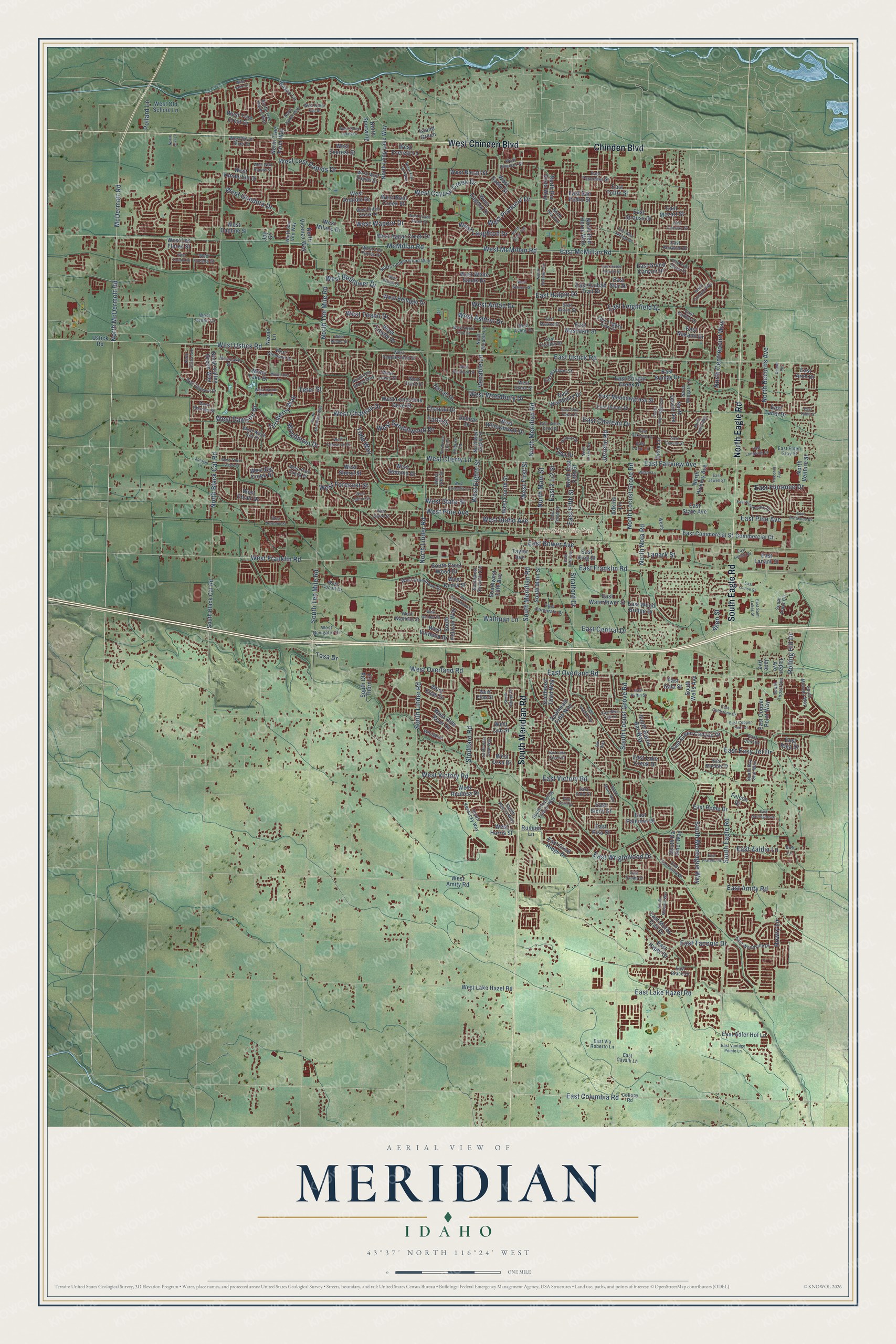
Meridian, Idaho Map Art
Building by building, with labeled streets and shaded relief.
12" x 18" Archival Matte Print
A Map of Home. A Work of Art.
Explore Meridian, Idaho from a whole new perspective. Created using aerial imagery and detailed geographic data, this map captures Meridian building by building, with labeled streets, familiar landmarks, and shaded topographical relief that highlights the natural contours of the landscape.
Combining modern data with the timeless character of a vintage atlas, this map is just as interesting up close as it is beautiful on the wall. Whether you grew up in Meridian, spent memorable years there, or call it home today, this unique map is a great way to celebrate a place that means something to you. Zoom in on the preview to look for your street, and then order a print to put your memories on the wall.
Three ways to hang it

Unframed archival matte, a black wood frame or a white wood frame.
Up close
Geography Worth Displaying
This map was created using accurate cartographic data and authoritative geographic sources, including the U.S. Geological Survey and the Census Bureau. The map brings together terrain, waterways, roads, and building detail. The majority of the streets are labeled, houses are accurately depicted, and the topography is derived from government sources. Combining local data with carefully composed color and shading leads to this beautifully detailed Meridian artwork for your wall.
Rather than simply showing street outlines, we’ve included as many of the street names as we could reasonably fit on the map while keeping their names legible. Zoom in on the high resolution preview to see exactly what’s on the map. We truly set out to create a statement piece for anyone who loves Meridian. So whether it’s for you, or a gift for someone you love, we hope this map of Meridian brings back fond memories.
Read the story behind this map of Meridian, Idaho from 2026.

Find your street
Names on the Meridian map
Every name below is printed on this map. Look for your street, your school, the park where you played, or the pond down the road.
Places and landmarks1
- Meridian City Hall
Streets and roads329
- West Chinden Boulevard
- South Meridian Road
- North Eagle Road
- Chinden Boulevard
- South Eagle Road
- West Ustick Road
- West Franklin Road
- East Overland Road
- East Ustick Road
- East Franklin Road
- East Amity Road
- East Columbia Road
- West Sandalwood Drive
- West Laughton Drive
- West Wapoot Drive
- West Producer Drive
- East Halpin Drive
- East Fairview Avenue
- Lanark Street
- McMillan Road
- South Locust Grove Road
- West McMillan Road
- North Linder Road
- North Meridian Road
- North Ten Mile Road
- North Locust Grove Road
- North Black Cat Road
- West Cherry Lane
- West Pine Avenue
- West Overland Road
Show all 329 streets
- East Pine Avenue
- South Linder Road
- East Lake Hazel Road
- East Victory Road
- McDermott Road
- North McDermott Road
- East McMillan Road
- South Ten Mile Road
- East Chateau Drive
- West Victory Road
- North Main Street
- East Taconic Drive
- West Chateau Drive
- West Lost Rapids Drive
- Stoddard Road
- East Easy Jet Drive
- West Cayuse Creek Drive
- East Leighfield Drive
- East Wrightwood Drive
- West Ashton Drive
- North Records Avenue
- West First Street
- South Montague Way
- West Gondola Drive
- West Woodbury Drive
- East Central Drive
- West Teano Drive
- North Centrepoint Way
- West Idaho Avenue
- West Eighth Street
- East Fifth Street
- Turnberry Way
- West Anton Drive
- Woodmont Drive
- East Florence Drive
- Jericho Road
- West Dawson Drive
- West State Street
- Stratford Drive
- Howry Lane
- East Zaldia Lane
- West Belltower Drive
- West Forecast Street
- East Bower Avenue
- North Nola Road
- Rolling Hill Drive
- Waltman Lane
- Todd Way
- Teter Street
- Venable Lane
- Pollard Lane
- Tasa Drive
- Allen Street
- Tana Drive
- East Green Canyon Drive
- East Washakie Street
- East Lake Creek Drive
- West Amity Road
- West Riodosa Drive
- East Pisa Street
- East Crest Ridge Drive
- South Pelican Way
- Delmar Drive
- Rumpel Lane
- East Commercial Street
- Southeast Fifth Way
- West White Sands Drive
- East Meadowgrass Street
- North Long Lake Way
- North Red Horse Way
- East State Avenue
- West Vanderbilt Drive
- East Copper Point Way
- West Bellagio Drive
- East San Pedro Street
- West Everest Street
- South Old Thorn Lane
- South Main Street
- East Lanark Street
- East Sicily Street
- North Tree Farm Way
- North Hickory Avenue
- West Root Creek Street
- South Black Cat Road
- West Willowbrook Drive
- North Vicenza Way
- West Apgar Creek Drive
- West Fourth Street
- East Watertower Street
- East King Street
- West Lake Hazel Road
- West Los Flores Street
- North Devlin Avenue
- East Cougar Creek Drive
- East Woodbury Drive
- Southeast Third Way
- South Crest Wood Drive
- West Daphne Street
- West Verbena Drive
- West Lonesome Dove Street
- East Palermo Drive
- East Adler Hof Lane
- West Cagney Drive
- East Mores Trail Drive
- Ustick Road
- North Valley Green Way
- West Tree Crest Drive
- West Bacall Street
- West Kimra Street
- Commercial Court
- West Olds River Drive
- South Bayou Bar Way
- West Sonoma Drive
- East Kaibab Trail Drive
- Taylor Avenue
- North Rio Vista Way
- Southwest Fifth Avenue
- South Wells Avenue
- West Everest Lane
- East Grand Canyon Drive
- East Kamay Drive
- West Milano Drive
- West Gable Street
- West Dover Drive
- North Venture Street
- East Nakano Drive
- East Rome Drive
- West Trestle Drive
- East Strauss Drive
- East Raja Drive
- West Sheryl Street
- North Spurwing
- Moon Lake Drive
- West Harris Street
- West Old School Lane
- East Tahiti Drive
- East Gala Street
- West Elias Drive
- North East Fifth Street
- South Da Vinci Way
- Chateau Drive
- East Wood Bridge Drive
- East Star Drive
- Dixie Lane
- Lynn Drive
- West Anatole Drive
- Darrah Drive
- East Tuttle Street
- West Orso Drive
- Basco Lane
- East Mozart Street
- West Big Creek Drive
- Adkins Lane
- West Cub Street
- East Hyper Drive
- Falcon Drive
- Island Green
- Topaz Avenue
- Jade Avenue
- Naomi Lane
- East Arch Drive
- Joy Street
- West Ditch Creek Drive
- East Cassidy Drive
- North Coppercloud Way
- West Silver River Street
- East Baldwin Street
- East Mackay Drive
- East Third Street
- Collopy Road
- West Park Creek Drive
- West Ashby Drive
- West Niemann Drive
- West Lowry Street
- West Los Flores Drive
- South Kentucky Way
- West Pebblestone Street
- South Arbor Circle
- West Claire Street
- West White Ash Drive
- East Corporate Drive
- North Old Stone Way
- West Greenhead Drive
- Northwest Eighth Street
- East Taormina Drive
- East Woodville Drive
- South Movado Way
- North Venable Lane
- East Pasacana Street
- South Peoria Way
- East Cavalli Lane
- North Tree Haven Way
- South Standing Timber Way
- East Redwick Drive
- West Director Street
- East Hunter Drive
- East Legacy View Drive
- East Anton Street
- Southwest Seventh Avenue
- West Navigator Drive
- North Wingate Lane
- South Bay Star Way
- West Cobalt Drive
- West Wolf Rapids Drive
- East Elden Gray Street
- West Waltman Street
- East Via Roberto Lane
- South Topaz Avenue
- North San Vito Way
- Whitehall
- West Charles Street
- West Jordan Lane
- West Torana Street
- Leisure Lane
- Moonlake Drive
- East Garber Drive
- East Italy Street
- West Claire Drive
- East Brace Drive
- East Loop Lane
- Bott Lane
- West Elias Street
- East Quin Drive
- North Isla Avenue
- West 14th Street
- Webb
- West Divide Creek Street
- North Price Avenue
- East Trail Blazer Drive
- East Clarene Street
- East Moskee Street
- East Lanark Drive
- West Torana Drive
- East Saint Lukes Street
- Barbara Drive
- Northwest 13th Street
- North Beaham Avenue
- East Fratello Street
- East Presidential Drive
- East Goldstone Drive
- North Aronmink Way
- South Bear Claw Way
- West Harbor Point Drive
- East Blue Tick Street
- East Comisky Street
- West Three Lakes Drive
- East Puffin Street
- East Lake Creek Street
- West Newland Street
- West Talamore Drive
- West Jayton Drive
- North Elisha Avenue
- East Oakcrest Drive
- East Longwing Lane
- North Laughridge Avenue
- East Blue Heron Street
- East Copper Point Drive
- East Louise Street
- South Marsala Way
- North Jayker Way
- West Stanhope Street
- West Salix Drive
- West Apple Pine Street
- West Thorn Creek Street
- North Linwood Way
- East James Court Drive
- West Gemstone Drive
- East Grand Canyon Street
- East Jewell Street
- West Greenhead Street
- West Camellia Lane
- Wilson Lane
- East Driftwood Drive
- North Justin Way
- West Wolf Rapids Street
- West Ryder Cup Drive
- East Vantage Pointe Lane
- East Darlington Drive
- South Murlo Way
- West Wilder Street
- Moonlake Street
- East Fifth Avenue
- West Wausau Street
- East Cayman Drive
- West Carlton Street
- West Gander Drive
- Sunfish Lane
- Records Avenue
- North Flat Tail Way
- North Lakes Avenue
- East Bear Springs Drive
- East Daulby Street
- South Riptide Place
- East Ionia Drive
- West Piazza Street
- East Tahiti Street
- North Levi Lane
- Duane Drive
- Bar Way
Names are listed as they appear on the printed map. Zoom into the product photos to find them.
About Meridian, Idaho
Meridian is a city of 117,635 people in Ada County, second in size only to Boise among Idaho's cities. It began in 1891 as a settlement called Hunter, on the Onweiler farm just north of where downtown stands now. In 1893 the new Odd Fellows lodge named itself Meridian because it sat on the Boise Meridian, the line the surveyors had run north and south, and the town took the name as well.
That year Christian Zenger filed a plat called Meridian on homestead land that belonged to his wife, Eliza Ann Zenger. Many of the first families were relatives who had left Missouri and come west by wagon or train. Water mattered from the start, since a settler needed a water source to get the patent for a homestead. The Settlers' Irrigation Ditch of 1892 turned the dry ground into farms, and in 1941 Meridian changed from a village to a city.
“The lowest days of the Great Depression brightened for area dairymen when the Ada County Dairymen's cooperative creamery began operation in 1929.”
- Apples and Italian prunesAround 1900 settlers planted orchards and put up packing houses and prune dryers beside the railroad tracks. The orchards grew many kinds of apples, along with Italian prunes. The fruit trade lasted until the mid-1940s, when it stopped paying and the businesses shut down.
- The Interurban to BoiseResidents raised $4,000 to extend the Interurban from Onweiler, at Meridian and Ustick Roads, into the village center. The last car stayed in Meridian overnight, then left early for Boise each morning with passengers and freight. A station and generator building rose at Meridian and Idaho Streets in 1912, and the tracks continued to Nampa.
- Challenge Butter for 40 yearsMembers of the dairymen's cooperative got milk checks that helped them pay their taxes and feed their families, and neighbors earned wages hauling milk and working in the plant. The creamery made Challenge Butter and ran seven days a week for 40 years. Later it worked with Wyeth Laboratories to make SMA baby formula. When it closed in 1970, local dairymen began shipping their milk to the creamery in Caldwell.
- Idaho's first congresswomanGracie Pfost, the first woman Idaho elected to Congress, is among Meridian's notable people. So is Wilbert Lee Gore, who created Gore-Tex.
Keep exploring Idaho
Meridian is one of 279 Idaho towns we've mapped. Every dot on the map is a print of its own.
The search covers every state, Idaho first.
Near Meridian
Order 2 or more town maps and save 10%. Shown in the size and finish you picked above, so they hang as a set.
- Kuna 12" x 18" / Archival Matte Print $39.99
- Eagle 12" x 18" / Archival Matte Print $39.99
- Garden City 12" x 18" / Archival Matte Print $39.99


More maps nearby: Star, Nampa, Boise, Hidden Springs and Middleton.
The art of mapping a place
How This Map Was Made
Real places. Remarkable detail. Discover the layers that turn geographic data into a map of home.

The view from above
Aerial imagery reveals the character of the land: woodland, open fields, and the patterns of a place.

The shape of the land
Elevation data brings hills, valleys, and subtle changes in the landscape into view.

The details of home
Roads, waterways, and building footprints come together to make the map feel unmistakably local.

Geography becomes art
Considered color, shading, and typography bring the layers together in a map made for your wall.


Process illustrated with Mendon, Massachusetts. Aerial imagery: USDA NAIP. Terrain: USGS 3D Elevation Program. Map details and finished artwork: KNOWOL.
The Details
About This Print
Choose an archival matte print, or a black or white Ayous wood frame. The archival matte print is unframed.
Select your size and finish above to see the matching product image and price.
Materials & Craftsmanship
A contemporary map with the character of a classic atlas, printed on archival matte paper. Optional frames are made from Ayous wood.
Your printed map does not include the watermark shown in the full-map preview.
Shipping & Delivery
Free shipping within the United States. Every print is made to order in the USA.
Buying a gift? Add a note in your cart and we'll include it. We never put prices in the package.
Prints ship within 2 to 3 business days. Allow 7 to 10 days total from ordering for delivery. Timing may vary during holidays or periods of high order volume.
Read our shipping policy.
Returns and damaged prints
Each print is made to order. Change-of-mind refunds are not available after production.
If your print arrives damaged, misprinted or incorrect, contact support@knowol.com within 30 days of receiving it. Include your order number, photos and a description of the issue.
Read our full refund and replacement policy. For questions about your order, email support@knowol.com.