


Search for another town


Free U.S. delivery 7 to 10 days after you order
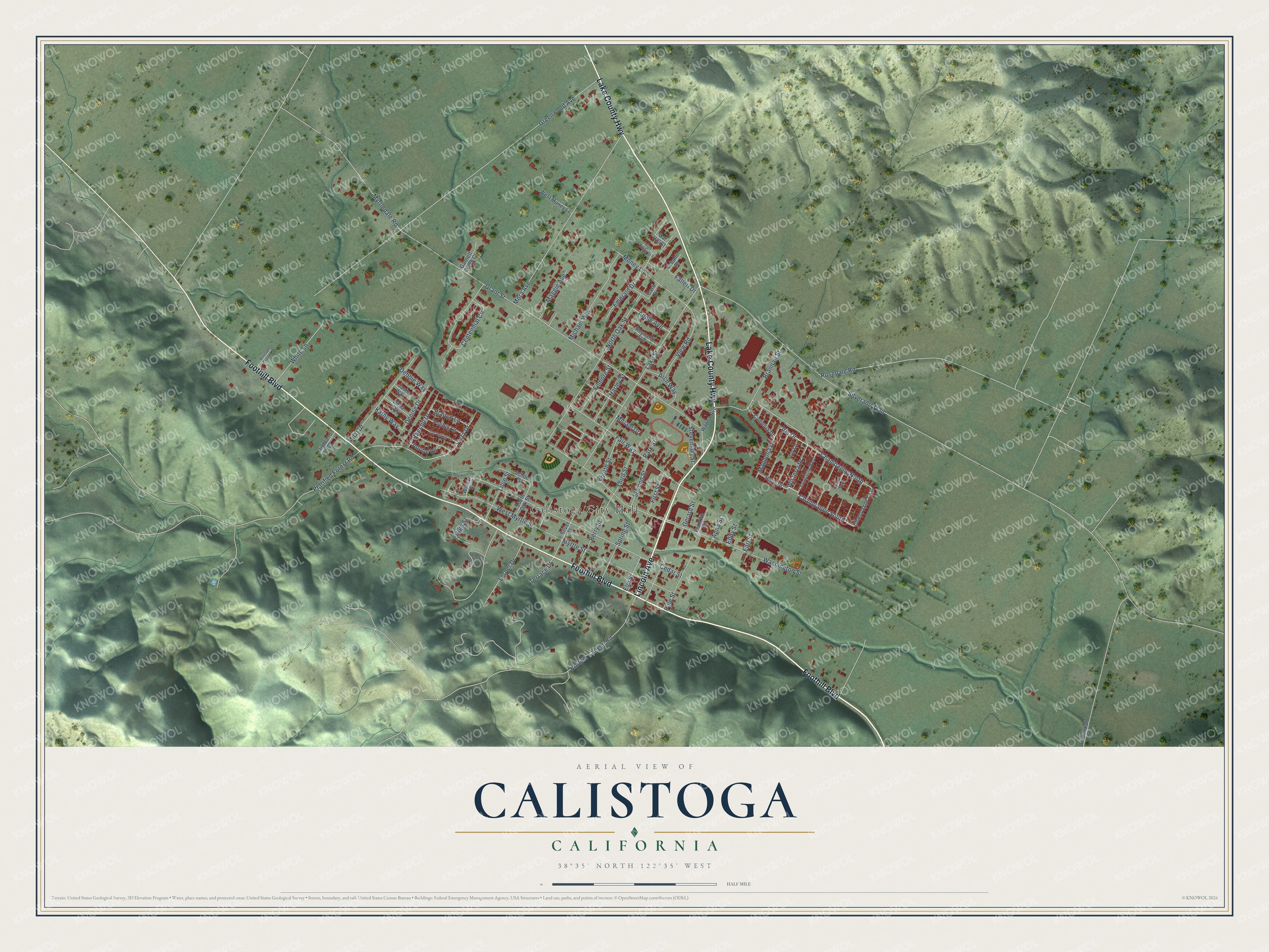
Calistoga, California Map Art
Building by building, with labeled streets and shaded relief.
12" x 18" Archival Matte Print
A Map of Home. A Work of Art.
Explore Calistoga, California from a whole new perspective. Created using aerial imagery and detailed geographic data, this map captures Calistoga building by building, with labeled streets, familiar landmarks, and shaded topographical relief that highlights the natural contours of the landscape.
Combining modern data with the timeless character of a vintage atlas, this map is just as interesting up close as it is beautiful on the wall. Whether you grew up in Calistoga, spent memorable years there, or call it home today, this unique map is a great way to celebrate a place that means something to you. Zoom in on the preview to look for your street, and then order a print to put your memories on the wall.
Three ways to hang it

Unframed archival matte, a black wood frame or a white wood frame.
Up close
Geography Worth Displaying
This map was created using accurate cartographic data and authoritative geographic sources, including the U.S. Geological Survey and the Census Bureau. The map brings together terrain, waterways, roads, and building detail. The majority of the streets are labeled, houses are accurately depicted, and the topography is derived from government sources. Combining local data with carefully composed color and shading leads to this beautifully detailed Calistoga artwork for your wall.
Rather than simply showing street outlines, we’ve included as many of the street names as we could reasonably fit on the map while keeping their names legible. Zoom in on the high resolution preview to see exactly what’s on the map. We truly set out to create a statement piece for anyone who loves Calistoga. So whether it’s for you, or a gift for someone you love, we hope this map of Calistoga brings back fond memories.
Read the story behind this map of Calistoga, California from 2026.

Find your street
Names on the Calistoga map
Every name below is printed on this map. Look for your street, your school, the park where you played, or the pond down the road.
Places and landmarks1
- Calistoga City Hall
Streets and roads89
- Foothill Boulevard
- Lincoln Avenue
- Lake County Highway
- Champagne South
- Wisteria Drive
- Iris Drive
- Cedar Street
- Grant Street
- Greenwood Avenue
- Silverado Trail
- Washington Street
- Lake Street
- Mora Avenue
- North Oak Street
- Rosedale Road
- Champagne North
- Myrtle Street
- Centennial Circle
- Fair Way
- Brannan Street
- West Myrtle Street
- Mitzi Drive
- Kortum Canyon Road
- Michael Way
- Petrified Forest Road
- Myrtledale Road
- Money Lane
- View Road
- Berry Street
- Pine Street
Show all 89 streets
- White Lane
- Lerner Drive
- Spring Street
- Rancho Drive
- Emerald Drive
- Maggie Avenue
- Magnolia Drive
- Harley Street
- Filmore Street
- Arch Way
- High Street
- Lillie Street
- Denise Drive
- Gerard Street
- Second Street
- Third Street
- Fourth Street
- Stevenson Street
- Adele Avenue
- First Street
- Vista Drive
- Blanco Lane
- Elm Street
- Terrace Drive
- Debbie Way
- Kathy Way
- Falleri Drive
- Adobe Lane
- Miriam Drive
- Anna Street
- Eddy Street
- Park Street
- Earl Street
- Champagne East
- Silver Street
- Wapoo Avenue
- Pueblo Lane
- West Money Lane
- South Oak Street
- School Street
- Holly Drive
- Camellia Drive
- Oat Hill Court
- Dena Way
- Garnett Creek Court
- Reynard Avenue
- Janis Way
- Dunaweal Lane
- Highland Court
- Franklin Street
- Willow Street
- Urbani Place
- Ivy Lane
- Carli Drive
- Champagne West
- Los Robles Lane
- High Rocks Drive
- Blossom Creek Lane
- Sherry North
Names are listed as they appear on the printed map. Zoom into the product photos to find them.
About Calistoga, California
Calistoga is a city of 5,228 people in the upper Napa Valley, in Napa County. Long before Americans came, the Wappo lived here in several villages, drawn by oaks that gave them acorns and by hot springs they used for healing. Their name for the place meant "Chicken Hawk Place." Settlers from the East began claiming land nearby in the 1840s, and one of the first homes was John York's log cabin, built in October 1845.
Sam Brannan had brought a shipload of Mormon settlers into San Francisco Bay in 1846. He grew rich after gold turned up at Coloma, and he bought more than 2,000 acres around the springs. He wanted a spa to rival Saratoga Springs in New York, and his resort around Mt. Lincoln opened to wealthy Californians in 1862. Brannan gave the place its name in the fall of 1867.
- Calistoga of SaraforniaBrannan liked to say a slip of the tongue gave him the name: he meant to call his spa the "Saratoga of California" and it came out "Calistoga of Sarafornia." Before that, the few Americans here called the place Hot Springs, while the Spanish and the Indians called it Agua Caliente. A cottage from his resort survives as the Sam Brannan Cottage, which joined the National Register in 1983.
- The railroad arrives in 1868The Napa Valley Railroad Company finished laying its track to Calistoga in 1868. Visitors from San Francisco could now ride the ferry and then the train to the springs, and the town became the transportation center of the upper valley and the door to Lake and Sonoma counties. The Napa Valley Railroad Depot joined the National Register in 1977.
- Stevenson's honeymoonIn its early years Calistoga lived on silver and mercury mines, on grapes, prunes and walnuts, and on visitors to the hot springs. One of those visitors was Robert Louis Stevenson, who spent his honeymoon with his wife, Fanny Vandegrift, in a cabin near the Silverado Mine on Mount Saint Helena. He wrote about the stay in The Silverado Squatters.
- Hot water at the Railway ExchangeIn 1920 Giuseppe Musante, who ran a candy store and soda fountain in town, was drilling at the Railway Exchange for a cold water well when he struck hot water instead. By 1924 he had a bottling line selling Calistoga Sparkling Mineral Water. Elwood Sprenger bought the small plant in 1970, and as the Calistoga Water Company it grew into a major name in bottled water.
- Fire twice in four yearsThe Tubbs Fire of 2017 began off Highway 128 and Bennett Lane in Calistoga, followed the same path as the Hanly Fire of 1964, killed at least 19 people and emptied nearly the whole town. In 2020 the Glass Fire forced the city to evacuate again. In 2024 PG&E paid for the Calistoga Resiliency Center, a microgrid of six hydrogen fuel cells built to power the city for at least 48 hours.
Keep exploring California
Calistoga is one of 1,990 California towns we've mapped. Every dot on the map is a print of its own.
The search covers every state, California first.
Near Calistoga
Order 2 or more town maps and save 10%. Shown in the size and finish you picked above, so they hang as a set.
- Deer Park 12" x 18" / Archival Matte Print $39.99
- Angwin 12" x 18" / Archival Matte Print $39.99
- St. Helena 12" x 18" / Archival Matte Print $39.99


More maps nearby: Pope Valley, Larkfield-Wikiup, Santa Rosa, Kenwood and Rutherford.
The art of mapping a place
How This Map Was Made
Real places. Remarkable detail. Discover the layers that turn geographic data into a map of home.

The view from above
Aerial imagery reveals the character of the land: woodland, open fields, and the patterns of a place.

The shape of the land
Elevation data brings hills, valleys, and subtle changes in the landscape into view.

The details of home
Roads, waterways, and building footprints come together to make the map feel unmistakably local.

Geography becomes art
Considered color, shading, and typography bring the layers together in a map made for your wall.


Process illustrated with Mendon, Massachusetts. Aerial imagery: USDA NAIP. Terrain: USGS 3D Elevation Program. Map details and finished artwork: KNOWOL.
The Details
About This Print
Choose an archival matte print, or a black or white Ayous wood frame. The archival matte print is unframed.
Select your size and finish above to see the matching product image and price.
Materials & Craftsmanship
A contemporary map with the character of a classic atlas, printed on archival matte paper. Optional frames are made from Ayous wood.
Your printed map does not include the watermark shown in the full-map preview.
Shipping & Delivery
Free shipping within the United States. Every print is made to order in the USA.
Buying a gift? Add a note in your cart and we'll include it. We never put prices in the package.
Prints ship within 2 to 3 business days. Allow 7 to 10 days total from ordering for delivery. Timing may vary during holidays or periods of high order volume.
Read our shipping policy.
Returns and damaged prints
Each print is made to order. Change-of-mind refunds are not available after production.
If your print arrives damaged, misprinted or incorrect, contact support@knowol.com within 30 days of receiving it. Include your order number, photos and a description of the issue.
Read our full refund and replacement policy. For questions about your order, email support@knowol.com.