
Search for another town


Free U.S. delivery 7 to 10 days after you order
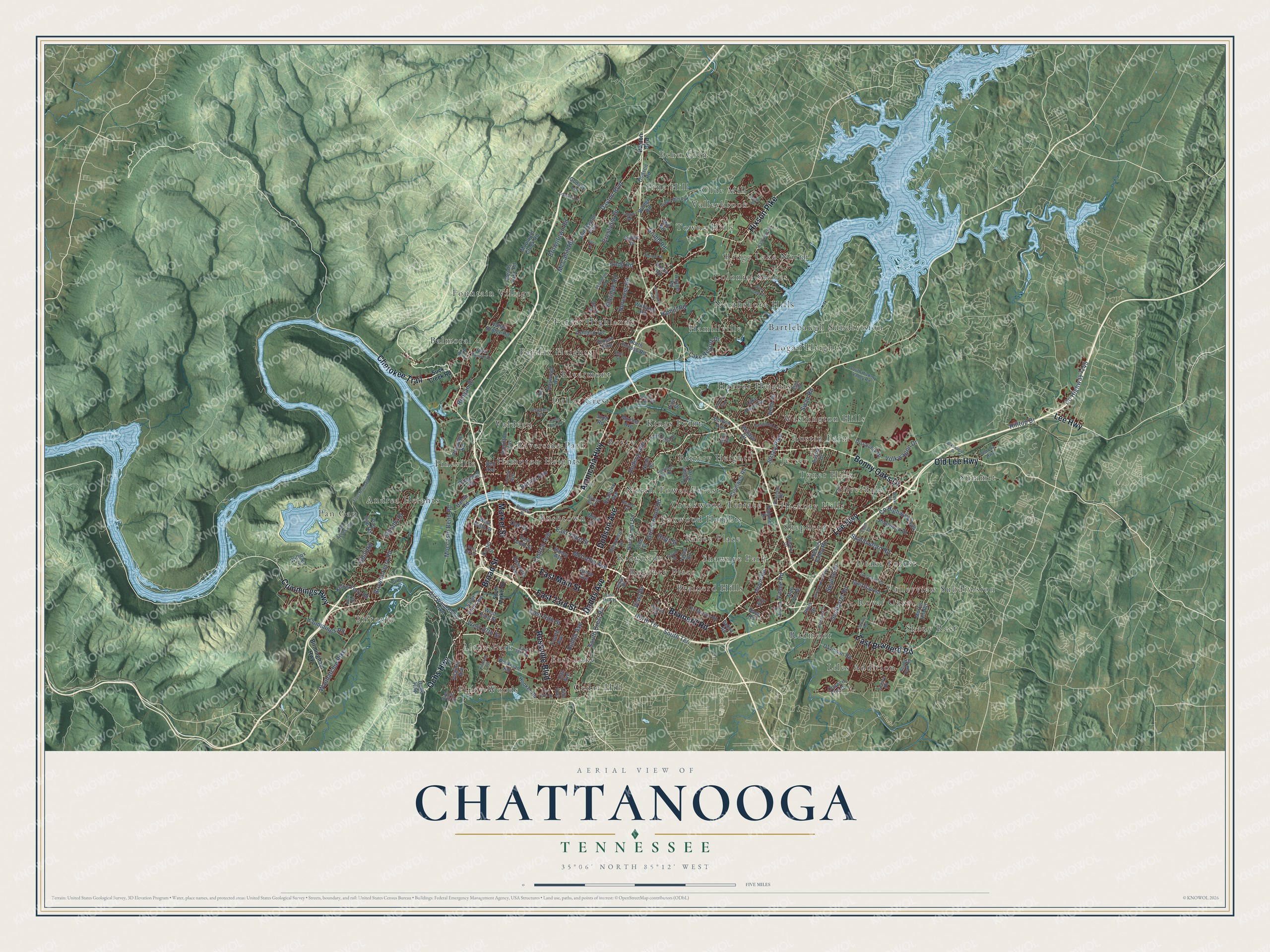
Chattanooga, Tennessee Map Art
Building by building, with labeled streets and shaded relief.
12" x 18" Archival Matte Print
A Map of Home. A Work of Art.
Explore Chattanooga, Tennessee from a whole new perspective. Created using aerial imagery and detailed geographic data, this map captures Chattanooga building by building, with labeled streets, familiar landmarks, and shaded topographical relief that highlights the natural contours of the landscape.
Combining modern data with the timeless character of a vintage atlas, this map is just as interesting up close as it is beautiful on the wall. Whether you grew up in Chattanooga, spent memorable years there, or call it home today, this unique map is a great way to celebrate a place that means something to you. Zoom in on the preview to look for your street, and then order a print to put your memories on the wall.
Three ways to hang it

Unframed archival matte, a black wood frame or a white wood frame.
Up close
Geography Worth Displaying
This map was created using accurate cartographic data and authoritative geographic sources, including the U.S. Geological Survey and the Census Bureau. The map brings together terrain, waterways, roads, and building detail. The majority of the streets are labeled, houses are accurately depicted, and the topography is derived from government sources. Combining local data with carefully composed color and shading leads to this beautifully detailed Chattanooga artwork for your wall.
Rather than simply showing street outlines, we’ve included as many of the street names as we could reasonably fit on the map while keeping their names legible. Zoom in on the high resolution preview to see exactly what’s on the map. We truly set out to create a statement piece for anyone who loves Chattanooga. So whether it’s for you, or a gift for someone you love, we hope this map of Chattanooga brings back fond memories.
Read the story behind this map of Chattanooga, Tennessee from 2026.

Find your street
Names on the Chattanooga map
Every name below is printed on this map. Look for your street, your school, the park where you played, or the pond down the road.
Places and landmarks56
- Tiftonia
- Royal Oaks
- Balmoral
- Summit
- North Tower Forest
- Austin Farm
- Andrea Heights
- Cedar Hill
- Northshore Hills
- Fountain Village
- Hampton Heights
- Brainerd Hills
Show all 56 places
- Pine Hill
- Hickory Hills
- Dallas Crest
- Valleyview Subdivision
- Kings Point
- Ridgeside
- Liles Addition
- Piney Woods
- Harbor Heights
- Ridge Lake North
- Pineville
- East Lake
- Talley Place
- Rivermont
- Riverside Park
- Towne Hills
- Logan Heights
- Valdeau
- Silverdale
- Jersey
- Bartlebaugh Subdivision
- Washington Hills
- Olde Mill
- Foxwood Heights
- Alton Park
- Pan Gap
- Fairfax Heights
- Radmoor
- Drake Forest
- Bushtown
- Boyce
- Battery Heights
- Echo Glen
- Shawnee Park
- Creekwood Terrace
- Hamillville
- Shepherd
- Colonial Shores
- Regency Place
- Forest Highlands
- Valleybrook
- Tyner Hills
- Shady Rest
- Northgate Park
Streets and roads182
- Bonny Oaks Drive
- Lee Highway
- Cummings Highway
- Brainerd Road
- Rossville Boulevard
- East 23rd Street
- Broad Street
- Market Street
- Dodson Avenue
- Dodds Avenue
- Amnicola Highway
- Hixson Pike
- East Main Street
- Old Lee Highway
- East Brainerd Road
- Cherokee Trail
- Ochs Highway
- South Crest Road
- Dayton Boulevard
- Barton Avenue
- East Third Street
- Shallowford Road
- McCallie Avenue
- Hamill Road
- Gunbarrel Road
- Central Avenue
- Browntown Road
- Browns Ferry Road
- Jersey Pike
- Oak Street
Show all 182 streets
- Wauhatchie Pike
- Gadd Road
- Grubb Road
- Moccasin Bend Road
- South Terrace
- North Terrace
- Norcross Road
- County Highway 1145
- Ogrady Drive
- Crestview Drive
- Greenwood Road
- Cummings Road
- Isbill Road
- Runyan Drive
- Lake Resort Drive
- County Highway 2154
- East 28th Street
- Volkwagon Drive
- Vance Road
- Eldridge Road
- Hilltop Drive
- West 37th Street
- McCahill Road
- Skyline Drive
- Hoyt Street
- Swan Road
- Vista Drive
- North Crest Road
- West Ninth Street
- Roanoke Avenue
- Morris Hill Road
- Bailey Avenue
- Glenwood Drive
- Talley Road
- Mountain Creek Road
- Hickory Valley Road
- Tunnel Boulevard
- Igou Gap Road
- Airport Road
- North Access Road
- Webb Road
- Kellys Ferry Road
- Old Dayton Pike
- 13th Avenue
- Whitehall Road
- Pineville Road
- 14th Avenue
- Fourth Avenue
- Adams Road
- Workman Road
- Reads Lake Road
- Ashland Terrace
- Virginia Avenue
- Cromwell Road
- Lake Haven Drive
- Hooker Road
- Davidson Road
- Haywood Avenue
- Wilcox Road
- East Tenth Street
- Old Wauhatchie Pike
- Saint Elmo Avenue
- Vance Avenue
- Hamilton Avenue
- Pinewood Drive
- Pan Gap Road
- Council Fire Drive
- Williams Road
- Carter Street
- Benton Avenue
- Milne Street
- Mill Road
- Discovery Drive
- Mari Jon Drive
- Godsey Lane
- Rossville Avenue
- Hamm Road
- West 33rd Street
- Valley Bridge Road
- Polymer Drive
- Austin Drive
- Pine Street
- Willard Drive
- Dodson Road
- Wilder Road
- Line Street
- Austin Road
- Sutton Drive
- Mueller Avenue
- Noah Street
- Debra Road
- Bass Road
- Judd Road
- Bell Avenue
- Phils Drive
- Birmingham Highway
- Suck Creek Road
- Fairview Road
- Wilcox Boulevard
- South Hickory Valley Road
- Lower Mill Road
- East 38th Street
- Conner Street
- Ocoee Street
- Old Mission Road
- Tva Access Road
- Forest Avenue
- Goodwin Road
- Ridge Crest Drive
- South Creek Road
- North Runyan Drive
- Fairwood Lane
- Altamont Road
- Kayla Circle
- Shady Fork Road
- Premier Drive
- West 57th Street
- Gentry Road
- Chapman Road
- Ridge Road
- Meharry Drive
- Battery Place
- Sherry Lane
- Elam Lane
- Eller Road
- Elm Street
- West Road
- Friar Road
- South Market Street
- Carter Lake Road
- North Concord Road
- Jenkins Road
- Lightfoot Mill Road
- Elder Mountain Road
- Volkswagon Drive
- Harrison Pike
- Delashmitt Road
- Parker Lane
- Eagle Drive
- Kirkland Avenue
- East 49th Street
- West 19th Street
- Walker Road
- Panorama Drive
- Thomas Lane
- Sylvan Drive
- Courtney Lane
- Taggart Road
- River Chase Road
- Folts Circle
- Rose Circle
- Allen Street
Names are listed as they appear on the printed map. Zoom into the product photos to find them.
About Chattanooga, Tennessee
Chattanooga is a city of 181,099 people and the county seat of Hamilton County, on the Tennessee River at the Georgia line. John Ross, the future Principal Chief of the Cherokee, founded Ross's Landing in 1816 along today's Broad Street. In 1838 the U.S. Army made the landing one of three large camps where Cherokees were held before they were forced west on the Trail of Tears. The next year the settlement at Ross's Landing incorporated as the city of Chattanooga.
River trade fed the young city, and when the railroad arrived in 1850 it became a boom town. Those rail lines made it a prize in the Civil War. Union troops took the city on September 9, 1863, and after losing at Chickamauga the Union army fell back inside it. Grant's forces broke the Confederate siege that November, taking Lookout Mountain and then routing the Confederates at Missionary Ridge on November 25. After the war, the railroads helped Chattanooga grow into a major industrial city.
- The great flood of 1867The worst flood in the city's history came in 1867. The river crested at 58 feet and covered all of Chattanooga. Congress created the TVA in 1933, and protecting the city shaped how its dams were planned. The highest flood since then, in 1973, reached nearly 37 feet. Without the dams it would have crested at 52.4 feet.
- Student sit-ins in 1960In 1960 students at Howard High School followed the lead of activists in Nashville and Greensboro. Led by class president Paul Walker and Lehman Pierce, as many as 200 Black students sat in at four stores on one downtown block. White mobs answered with threats and violence. On the third day the mayor had firefighters turn hoses on the crowds. Three months later the city agreed to desegregate downtown.
- Five women who beat the KlanThree Ku Klux Klan members opened fire on five Black women on East 9th Street, now M. L. King Blvd., on April 19, 1980. Fannie Crumsey, Opal Lee Jackson, Viola Ellison, Katherine O. Johnson and Lela Mae Evans all survived. When an all-white jury acquitted the gunmen, the women sued the Klan, and in 1982 federal courts ordered it to pay them $535,000. Lawyers went on to use the case to dismantle the Klan nationwide.
- Home of the Choo ChooIn the 1930s people called Chattanooga the "Dynamo of Dixie." Glenn Miller's 1941 big-band hit "Chattanooga Choo Choo" grew out of that image and carried the city's name around the world.
- Gig City since 2010In September 2010 the city-owned utility EPB began offering one-gigabit internet. It was the first service of its kind run by a government in the United States, and it earned Chattanooga the nickname Gig City. In August 2012 the city unveiled Chatype, the first typeface made for an American city and the world's first crowd-funded custom typeface.
Keep exploring Tennessee
Chattanooga is one of 640 Tennessee towns we've mapped. Every dot on the map is a print of its own.
The search covers every state, Tennessee first.
Near Chattanooga
Order 2 or more town maps and save 10%. Shown in the size and finish you picked above, so they hang as a set.
- Ridgeside 12" x 18" / Archival Matte Print $39.99
- Highland Park 12" x 18" / Archival Matte Print $39.99
- Red Bank 12" x 18" / Archival Matte Print $39.99


More maps nearby: East Ridge, Harrison, Signal Mountain, Walden and Lookout Mountain.
The art of mapping a place
How This Map Was Made
Real places. Remarkable detail. Discover the layers that turn geographic data into a map of home.

The view from above
Aerial imagery reveals the character of the land: woodland, open fields, and the patterns of a place.

The shape of the land
Elevation data brings hills, valleys, and subtle changes in the landscape into view.

The details of home
Roads, waterways, and building footprints come together to make the map feel unmistakably local.

Geography becomes art
Considered color, shading, and typography bring the layers together in a map made for your wall.


Process illustrated with Mendon, Massachusetts. Aerial imagery: USDA NAIP. Terrain: USGS 3D Elevation Program. Map details and finished artwork: KNOWOL.
The Details
About This Print
Choose an archival matte print, or a black or white Ayous wood frame. The archival matte print is unframed.
Select your size and finish above to see the matching product image and price.
Materials & Craftsmanship
A contemporary map with the character of a classic atlas, printed on archival matte paper. Optional frames are made from Ayous wood.
Your printed map does not include the watermark shown in the full-map preview.
Shipping & Delivery
Free shipping within the United States. Every print is made to order in the USA.
Buying a gift? Add a note in your cart and we'll include it. We never put prices in the package.
Prints ship within 2 to 3 business days. Allow 7 to 10 days total from ordering for delivery. Timing may vary during holidays or periods of high order volume.
Read our shipping policy.
Returns and damaged prints
Each print is made to order. Change-of-mind refunds are not available after production.
If your print arrives damaged, misprinted or incorrect, contact support@knowol.com within 30 days of receiving it. Include your order number, photos and a description of the issue.
Read our full refund and replacement policy. For questions about your order, email support@knowol.com.