
Search for another town


Free U.S. delivery 7 to 10 days after you order
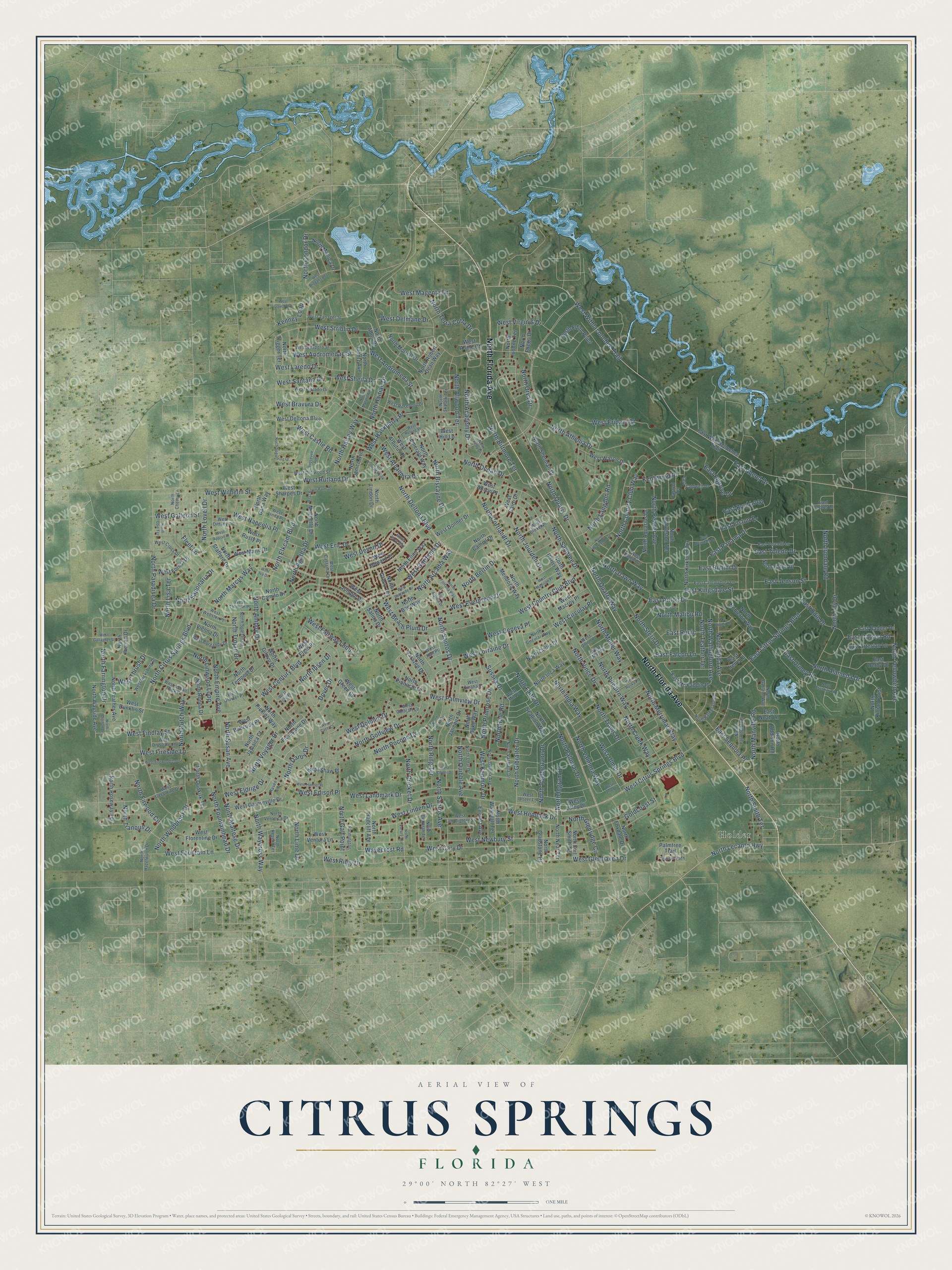
Citrus Springs, Florida Map Art
Building by building, with labeled streets and shaded relief.
12" x 18" Archival Matte Print
A Map of Home. A Work of Art.
Explore Citrus Springs, Florida from a whole new perspective. Created using aerial imagery and detailed geographic data, this map captures Citrus Springs building by building, with labeled streets, familiar landmarks, and shaded topographical relief that highlights the natural contours of the landscape.
Combining modern data with the timeless character of a vintage atlas, this map is just as interesting up close as it is beautiful on the wall. Whether you grew up in Citrus Springs, spent memorable years there, or call it home today, this unique map is a great way to celebrate a place that means something to you. Zoom in on the preview to look for your street, and then order a print to put your memories on the wall.
Three ways to hang it

Unframed archival matte, a black wood frame or a white wood frame.
Up close
Geography Worth Displaying
This map was created using accurate cartographic data and authoritative geographic sources, including the U.S. Geological Survey and the Census Bureau. The map brings together terrain, waterways, roads, and building detail. The majority of the streets are labeled, houses are accurately depicted, and the topography is derived from government sources. Combining local data with carefully composed color and shading leads to this beautifully detailed Citrus Springs artwork for your wall.
Rather than simply showing street outlines, we’ve included as many of the street names as we could reasonably fit on the map while keeping their names legible. Zoom in on the high resolution preview to see exactly what’s on the map. We truly set out to create a statement piece for anyone who loves Citrus Springs. So whether it’s for you, or a gift for someone you love, we hope this map of Citrus Springs brings back fond memories.
Read the story behind this map of Citrus Springs, Florida from 2026.

Find your street
Names on the Citrus Springs map
Every name below is printed on this map. Look for your street, your school, the park where you played, or the pond down the road.
Places and landmarks1
- Holder
Streets and roads328
- North Florida Avenue
- West Eric Drive
- North Citrus Springs Boulevard
- North Santos Drive
- North Merrimac Way
- West Citrus Springs Boulevard
- North Quarry Drive
- North Gibralter Drive
- West Andromeda Street
- North Elkcam Boulevard
- North Deltona Boulevard
- North Athenia Drive
- North Golfview Drive
- North Travis Drive
- East Citrus Springs Boulevard
- West Withlacoochee Trail
- North Maltese Drive
- North Sandree Drive
- West Magenta Drive
- North Alameda Drive
- North Paradisea Drive
- North Fountainhead Drive
- North Voyager Drive
- West Riley Drive
- West Country Club Boulevard
- West Hackberry Place
- West Century Boulevard
- West Gardenia Drive
- North Academy Drive
- North Quarry Way
Show all 328 streets
- North Pitcairn Way
- North Creek Way
- North Country Club Way
- North Lily Drive
- North Vince Drive
- North Ocean Drive
- North Firwood Circle
- West Kenmore Drive
- North Cortlandt Drive
- West Lorraine Drive
- East Abend Drive
- East Kingsdale Street
- West Rutland Drive
- West Landmark Drive
- North Pocono Drive
- North Primrose Drive
- West Ulmer Drive
- West Newbury Street
- North India Way
- North Langdon Road
- North Amboy Drive
- North Ibsen Drive
- East Anton Drive
- East Bimini Drive
- West Palmview Drive
- North Lime Drive
- West Glenhaven Drive
- West Sheila Drive
- North Tamberlane Drive
- East Toledo Drive
- East Odin Drive
- West Edison Place
- West Fairway Loop
- West Virginis Drive
- West Striblin Drive
- West Cary Drive
- North Manville Road
- North Haitian Drive
- North Bertin Drive
- West Evergreen Drive
- North Farrington Drive
- Kenney Loop
- East Panama Drive
- West Beach Plum Drive
- North Cricket Drive
- East Elgrove Drive
- North Condor Drive
- West Fireside Lane
- North Biscayne Drive
- North Palomar Drive
- North Pewter Avenue
- North Faith Drive
- North Glenridge Circle
- North Biltmore Terrace
- North Malibu Road
- Wavecrest Road
- West Naegelia Place
- North Allwood Terrace
- North Irondale Road
- West Andromedae Street
- North Trojan Drive
- North Linwood Loop
- North Windbrook Drive
- North Jourden Drive
- North Santos Avenue
- West Wilhelm Street
- West Findlay Street
- North Yellowbird Avenue
- North Stern Drive
- West Fountain Lane
- North Galt Point
- North Tranquil Drive
- North Elida Avenue
- West Delmane Drive
- West Bravura Drive
- East Carson Road
- West Alhambra Drive
- Goldcoast Street
- West Linden Drive
- North Arcadia Way
- North Wallingford Avenue
- North Lecanto Highway
- North Agatha Drive
- North Saponaria Drive
- North Susan Avenue
- West Laredo Drive
- West Devon Drive
- West Eridani Court
- West Dolphin Drive
- North Teather Terrace
- West Thrush Drive
- North Dawn Way
- North Terra Cotta Drive
- West Castle Road
- Dover Drive
- East Jenson Street
- North Hale Road
- West Hemlock Drive
- West Eldrige Drive
- North Halsey Way
- East Urmey Place
- North Smith Terrace
- North Valmora Way
- North Waycross Way
- North Empire Avenue
- North Lisa Terrace
- North Darby Drive
- North Dutch Way
- North Quibble Avenue
- North Marcus Way
- West Santana Drive
- North Ingram Drive
- Sussex Drive
- North Ring Terrace
- North Lovell Drive
- East Falcon Lane
- West Circular Place
- West Galleon Street
- East Sequoia Place
- Kentwood Place
- West Geneva Place
- East Byrd Loop
- North Muller Way
- East Elston Place
- North Orva Drive
- East Runic
- Fleet Lane
- West Deltona Boulevard
- North Sherman Drive
- North Sarazen Drive
- North Adler Drive
- West Arbutus Drive
- East Withlacoochee Trail
- North Camilo Drive
- North Ronda Drive
- North Janeaux Drive
- North Mendoza Way
- North Tempest Drive
- North Gilovu Drive
- North Stafford Drive
- East Derby Drive
- West Marie Drive
- West Sharpes Drive
- East Artesian Lane
- North Patch Drive
- North Frantz Avenue
- North Fieldstone Drive
- North Pickinz Way
- North Greco Terrace
- North Mitchelle Drive
- North Elliot Way
- North Fuego Drive
- North Feather Avenue
- North Collie Drive
- East Mc Faddin Place
- West Wason Drive
- East Badger Drive
- North Pinnacle Drive
- North Jamaica Court
- West Gainseville Drive
- North Inca Way
- North Aquarius Drive
- North Kirkland Terrace
- West Florentine Drive
- North Waterfall Terrace
- West Donner Drive
- East Noah Lane
- North Nobleton Way
- North Wayside Avenue
- North Addison Road
- West Babcock Place
- North Harris Way
- West Dunklin Street
- North Foxdale Drive
- North Roseway Terrace
- North Neal Terrace
- North Iberian Drive
- Palmtree Trail
- North Monica Drive
- North Dyke Way
- North Gladstone Drive
- North Galveston Terrace
- North Emerald Way
- North Dunkirk Terrace
- North Edith Point
- North Vienna Drive
- West Forest Drive
- North Bee Way
- West Cairo Drive
- North Morrell Drive
- Everest Avenue
- North Lindon Drive
- North Fort Smith Terrace
- West Lafoy Drive
- North Scallion Way
- West Ventura Lane
- West Macroy Place
- North Ivonne Terrace
- North Salina Drive
- West Elgin Place
- West Howard Place
- North Robert Dean Way
- North Camcil Drive
- North Dana Way
- West Jonquil Drive
- North Trigger Terrace
- North Janice Avenue
- West Shaw Place
- North Radcliff Avenue
- West Green Court
- North Killian Point
- East Irene Lane
- West Rusty Place
- West Anson Place
- West Adele Court
- West Hill Lane
- North Galena Avenue
- North Garland Way
- West Geraldine Drive
- North Spartan Drive
- West Dellwood Street
- East Caldwell Drive
- North Parker Loop
- East Vercelli Lane
- West Castania Drive
- North Hazelwood Drive
- West Vespero Street
- North Veronica Drive
- West Indian Rock Place
- West Vicksburg Drive
- North Val Halla Drive
- East Canturybury Lane
- West Pintado Drive
- West Dittany Drive
- North Cherry Lane
- North Udal Drive
- West Mac Place
- West Lamplighter Street
- West Tanager Street
- North Yarmouth Terrace
- West Burgandy Drive
- West Roseboro Drive
- West Talinum Place
- West Webster Place
- West Drexel Place
- West Gloster Place
- West Cross Drive
- West Linda Place
- North Circular Way
- West Drysdale Lane
- North Deborah Terrace
- West Union Place
- Sunset Path
- West Golfcart Lane
- West Ulster Lane
- North Skylark Terrace
- West Bimini Drive
- North Regent Terrace
- Caravel Terrace
- Farmington
- West Omaha Place
- East Cactus Lane
- Raven Lane
- West Hall Place
- West Mill Place
- North Wayland Avenue
- North Triana Drive
- North Spaulding Drive
- West Hamlet Place
- North Mataro Avenue
- West Royal Palm Drive
- North Alpinia Drive
- West Oliver Drive
- North Varsity Avenue
- West Iva Drive
- West Firewood Loop
- West Madison Place
- West Lynx Drive
- North Escobar Road
- North Fontana Way
- West Gallagher Street
- West Zoo Drive
- West Braganza Street
- North Conrad Point
- East Avondale Drive
- West Gaucho Drive
- North Abby Drive
- Roosevelt Avenue
- East Abady Lane
- West Belgrade Drive
- North Dothan Drive
- West Ruska Place
- West Appian Place
- West Rolling Place
- North Davy Way
- North Lois Terrace
- West Cacti Court
- West Echo Place
Names are listed as they appear on the printed map. Zoom into the product photos to find them.
About Citrus Springs, Florida
The Mackle brothers' Deltona company built Citrus Springs on 15,000 acres that had belonged to the Camp Phosphate company. They switched on the landmark water fountain at the opening on January 4, 1970, and by their count flew 70,000 people from frozen northern cities to see it that month. Their sales manager was former New York Yankees great Bill Skowron, a Chicago native.
When Citrus Springs was planned in 1969, its builders promised land for an elementary school, a middle school and a high school at no charge to the county. Their goal was that no home would be more than 2 miles from a school.
Keep exploring Florida
Citrus Springs is one of 1,067 Florida towns we've mapped. Every dot on the map is a print of its own.
The search covers every state, Florida first.
Near Citrus Springs
Order 2 or more town maps and save 10%. Shown in the size and finish you picked above, so they hang as a set.
- Pine Ridge 12" x 18" / Archival Matte Print $39.99
- Hernando 12" x 18" / Archival Matte Print $39.99
- Dunnellon 12" x 18" / Archival Matte Print $39.99


More maps nearby: Beverly Hills, Black Diamond, Rainbow Springs, Citrus Hills and Inverness Highlands North.
The art of mapping a place
How This Map Was Made
Real places. Remarkable detail. Discover the layers that turn geographic data into a map of home.

The view from above
Aerial imagery reveals the character of the land: woodland, open fields, and the patterns of a place.

The shape of the land
Elevation data brings hills, valleys, and subtle changes in the landscape into view.

The details of home
Roads, waterways, and building footprints come together to make the map feel unmistakably local.

Geography becomes art
Considered color, shading, and typography bring the layers together in a map made for your wall.


Process illustrated with Mendon, Massachusetts. Aerial imagery: USDA NAIP. Terrain: USGS 3D Elevation Program. Map details and finished artwork: KNOWOL.
The Details
About This Print
Choose an archival matte print, or a black or white Ayous wood frame. The archival matte print is unframed.
Select your size and finish above to see the matching product image and price.
Materials & Craftsmanship
A contemporary map with the character of a classic atlas, printed on archival matte paper. Optional frames are made from Ayous wood.
Your printed map does not include the watermark shown in the full-map preview.
Shipping & Delivery
Free shipping within the United States. Every print is made to order in the USA.
Buying a gift? Add a note in your cart and we'll include it. We never put prices in the package.
Prints ship within 2 to 3 business days. Allow 7 to 10 days total from ordering for delivery. Timing may vary during holidays or periods of high order volume.
Read our shipping policy.
Returns and damaged prints
Each print is made to order. Change-of-mind refunds are not available after production.
If your print arrives damaged, misprinted or incorrect, contact support@knowol.com within 30 days of receiving it. Include your order number, photos and a description of the issue.
Read our full refund and replacement policy. For questions about your order, email support@knowol.com.