
Search for another town


Free U.S. delivery 7 to 10 days after you order
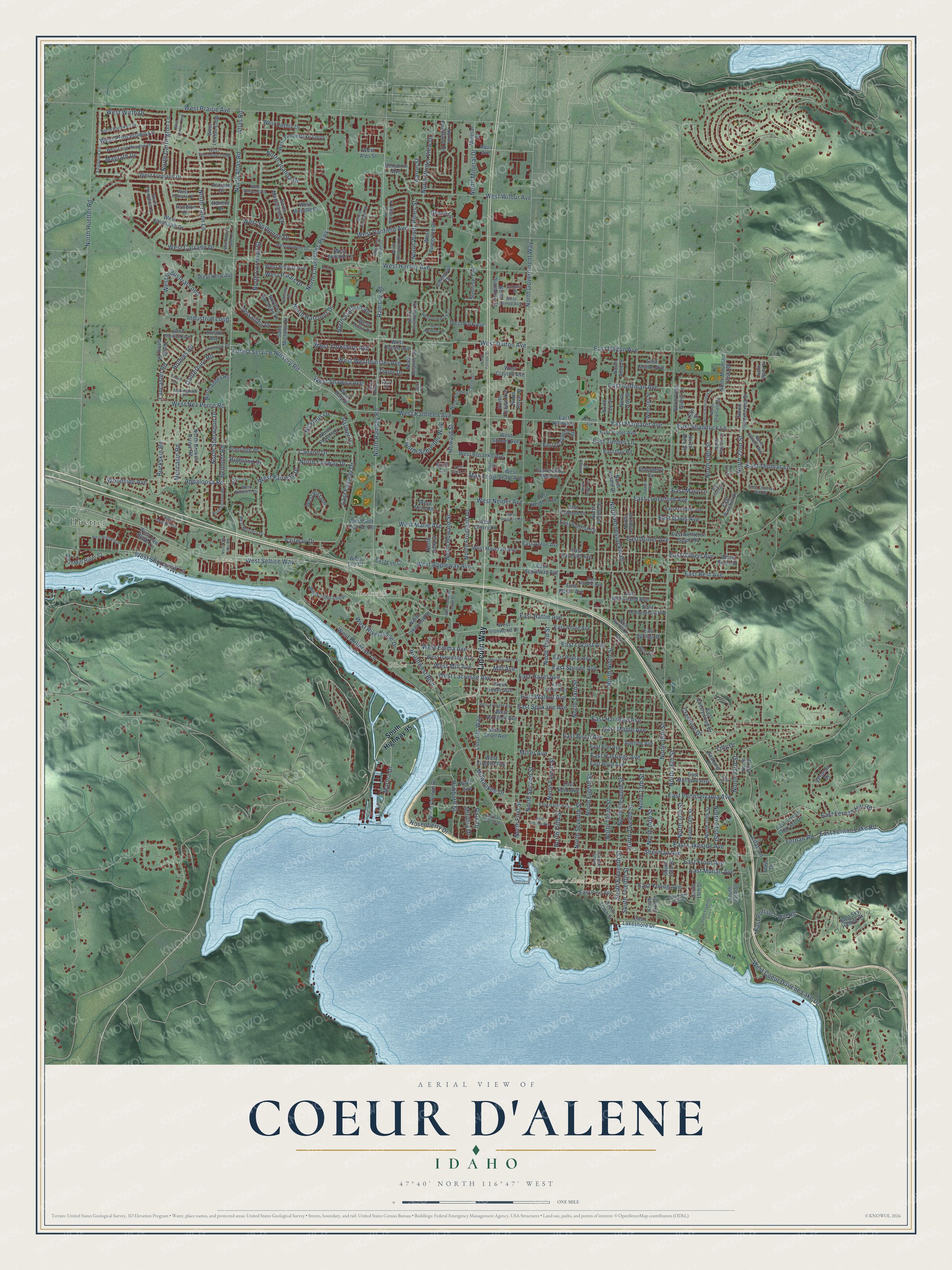
Coeur d'Alene, Idaho Map Art
Building by building, with labeled streets and shaded relief.
12" x 18" Archival Matte Print
A Map of Home. A Work of Art.
Explore Coeur d'Alene, Idaho from a whole new perspective. Created using aerial imagery and detailed geographic data, this map captures Coeur d'Alene building by building, with labeled streets, familiar landmarks, and shaded topographical relief that highlights the natural contours of the landscape.
Combining modern data with the timeless character of a vintage atlas, this map is just as interesting up close as it is beautiful on the wall. Whether you grew up in Coeur d'Alene, spent memorable years there, or call it home today, this unique map is a great way to celebrate a place that means something to you. Zoom in on the preview to look for your street, and then order a print to put your memories on the wall.
Three ways to hang it

Unframed archival matte, a black wood frame or a white wood frame.
Up close
Geography Worth Displaying
This map was created using accurate cartographic data and authoritative geographic sources, including the U.S. Geological Survey and the Census Bureau. The map brings together terrain, waterways, roads, and building detail. The majority of the streets are labeled, houses are accurately depicted, and the topography is derived from government sources. Combining local data with carefully composed color and shading leads to this beautifully detailed Coeur d'Alene artwork for your wall.
Rather than simply showing street outlines, we’ve included as many of the street names as we could reasonably fit on the map while keeping their names legible. Zoom in on the high resolution preview to see exactly what’s on the map. We truly set out to create a statement piece for anyone who loves Coeur d'Alene. So whether it’s for you, or a gift for someone you love, we hope this map of Coeur d'Alene brings back fond memories.
Read the story behind this map of Coeur d'Alene, Idaho from 2026.

Find your street
Names on the Coeur d'Alene map
Every name below is printed on this map. Look for your street, your school, the park where you played, or the pond down the road.
Places and landmarks5
- Coeur d'Alene City Hall
- Huetter
- Atlas
- Gibbs
- Blackwell
Streets and roads327
- Lincoln Way
- West Seltice Way
- West Kathleen Avenue
- West Dalton Avenue
- North Harcourt Drive
- Rosenberry Drive
- Hubbard Street
- North Fairway Drive
- Park Drive
- North Seventh Street
- East Margaret Avenue
- West Fairway Drive
- West Sorbonne Drive
- South Eleventh Street
- North Windy Pines Street
- North Winter View Drive
- Howard Street
- Palmer Drive
- North Government Way
- North Fourth Street
- North 15th Street
- North Ramsey Road
- Ramsey Road
- Atlas Road
- North Atlas Road
- West Hanley Avenue
- North Ninth Street
- West Prairie Avenue
- North Fifth Street
- North Twelfth Street
Show all 327 streets
- North Sixth Street
- Fairway Drive
- North Huetter Road
- Northwest Boulevard
- North Second Street
- North Eighth Street
- East Lakeside Avenue
- North Third Street
- North Eleventh Street
- East Dalton Avenue
- North 13th Street
- North Tenth Street
- West Wilbur Avenue
- West Appleway Avenue
- Sherman Avenue
- East Best Avenue
- West Canfield Avenue
- North Courcelles Parkway
- North Honeysuckle Drive
- East Front Avenue
- North 19th Street
- North 17th Street
- North 14th Street
- North 22nd Street
- North 16th Street
- East Fernan Hill Road
- East Mullan Avenue
- East Birch Avenue
- North Carrington Lane
- East Harrison Avenue
- East Lunceford Avenue
- West Coeur D'Alene Lake Drive
- West Nez Perce Road
- East Pennsylvania Avenue
- North Cornwall Street
- East Hazel Avenue
- East Spokane Avenue
- North Mineral Drive
- East Hastings Avenue
- East Walnut Avenue
- North Sherwood Drive
- West Riverstone Drive
- East Potlatch Hill Road
- East Gilbert Avenue
- East Fernan Lake Road
- East Locust Avenue
- East Thomas Lane
- North First Street
- West Mill Avenue
- East Young Avenue
- Moccasin Road
- Fernan Road
- East Timber Lane
- North Fruitland Lane
- North 21st Street
- Buckskin Road
- West Princetown Lane
- East Davis Avenue
- West Emma Avenue
- East Hattie Avenue
- Mill Avenue
- East Maple Avenue
- West Lacrosse Avenue
- West Industrial Loop
- West Shoreview Lane
- East Spruce Avenue
- East Shadduck Lane
- North Schreiber Way
- North Talon Lane
- East Hoffman Avenue
- North Howard Street
- Canyon Drive
- Forest Service Nursery Road
- West Westminster Avenue
- West Bellerive Lane
- North Joanna Drive
- Appaloosa Road
- Belmont Road
- West Neider Avenue
- Crestline Drive
- West Marie Avenue
- East Fairway Drive
- Marina Drive
- Sunrise Terrace
- Military Drive
- East Stiner Avenue
- South Twelfth Street
- West Calzado Drive
- Lilac Lane
- West Wirth Drive
- North 23rd Street
- Industrial Loop
- Holmes Road
- West Yorkshire Avenue
- North Stafford Road
- Nicklaus Drive
- Canterbury Road
- West Shawna Avenue
- Woodside Avenue
- Lancaster Road
- West Palais Drive
- Versailles Drive
- Highland Drive
- Magrath Drive
- Milwaukee Drive
- East Mary Lane
- Miller Avenue
- Grove Lane
- Timor Drive
- Aaron Street
- Max Loop
- Lilly Drive
- South Highway 95
- West Ironwood Drive
- North Atlantic Drive
- West Bolivar Avenue
- West Ocean Avenue
- Knoll Lane
- Saint Michelle Drive
- East Sky Harbor Drive
- East Montana Avenue
- North Madellaine Drive
- East Boyd Avenue
- West Pinegrove Drive
- West Freeland Drive
- East Homestead Avenue
- West Davidson Avenue
- East Fernan Terrace Drive
- East Elm Avenue
- North Player Drive
- East McFarland Avenue
- North College Drive
- West Timberlake Loop
- West Vista Drive
- West Jonshawk Drive
- North 18th Street
- North Anne Street
- North Broken Arrow Road
- West Loxton Loop
- East Borah Avenue
- Mineral Drive
- North Julia Street
- South Tenth Street
- East Poplar Avenue
- North Tenth Place
- North La Rochelle Drive
- Elderberry Circle
- Pineridge Drive
- West Harrison Avenue
- East Annie Avenue
- North Lakewood Drive
- East Nettleton Gulch Road
- West Linden Avenue
- West John Loop
- East Haycraft Avenue
- West Park Avenue
- Accipter Drive
- South 14th Street
- North Forest Street
- North Heartland Drive
- East Pinehill Drive
- North 20th Street
- West Bosanko Avenue
- West Haycraft Avenue
- River Avenue
- West Clayton Avenue
- South 19th Street
- East Lakeshore Drive
- West Voltaire Lane
- West Mill River Court
- North Mountain Vista Drive
- West Sunset Avenue
- East Dragonfly Drive
- West Hern Avenue
- South 23rd Street
- North Huntercrest Drive
- North Abbey Road
- White Pines Drive
- West Daylily Drive
- South 16th Street
- East Violet Avenue
- East Knotty Pine Lane
- East Cherrywood Drive
- West Short Avenue
- West Virginia Avenue
- West Cherry Lane
- East Neider Avenue
- East Sunrise Drive
- East Pine Avenue
- Webster Street
- North Troy Street
- North Ezy Street
- West Saw Blade Lane
- East Appleway Avenue
- East Anton Avenue
- North Sunshine Street
- East Ichabod Lane
- East Syringa Drive
- North Crown Avenue
- West Daly Drive
- East Kathleen
- West Moselle Drive
- North Arthur Street
- North Royal Street
- East Milton Avenue
- West Seale Avenue
- West Golf Course Road
- North Echo Glenn Lane
- East Day Road
- East Reid Avenue
- Adeline Avenue
- North Hill Drive
- East Lee Court
- West Alps Street
- North Estate Drive
- Pandion Drive
- Galewood Drive
- Hedburg Drive
- North Alex Street
- West Deni Road
- Benjamin Avenue
- Burl Lane
- West Tullis Drive
- Veranda Drive
- Bristol Avenue
- West Lee Court
- Aqua Avenue
- Ranero Drive
- 16th Street
- Theis Drive
- Fairborne Lane
- Sulu Street
- East Garden Avenue
- West Thorndale Loop
- East Thomas Hill Drive
- West Long Meadow Drive
- East Linden Avenue
- West Dumont Drive
- West Masters Drive
- North Building Center Drive
- North Hourglass Drive
- East Randle Avenue
- South Ninth Street
- East Fruitdale Avenue
- North Deerfield Drive
- North Idlewood Drive
- North Bardwell Drive
- North Christopher Drive
- West Hillcrest Drive
- North Sutters Way
- North Calispel Drive
- West Sherlock Avenue
- West Furcula Drive
- West Sunup Avenue
- Nottingham Lane
- North Syringa Drive
- North Aldridge Drive
- North Playfair Street
- Rose Lane
- North Wade Street
- State Street
- Bolivar Lane
- East Indiana Avenue
- West Davidson Street
- North Parkwood Circle
- West Idewild Loop
- West Lennox Loop
- South Floating Green Drive
- East Tower Pointe Drive
- West Tea Olive Lane
- North Alderbrook Drive
- North Pioneer Drive
- Laurel Avenue
- West Pinehill Drive
- Greenwich Road
- West Spokane Avenue
- North Belmont Road
- West Riverway Place
- Hillcrest Circle
- West Rimbaud Avenue
- Sunburst Street
- West Fort Grounds Drive
- West Ironwood Center Drive
- West Mulberry Lane
- Twelfth Street
- West Cosgrove Road
- North Driver Lane
- Belleville Drive
- North Harris Hawk Lane
- East 21st Place
- North Old Atlas Road
- West Clady Lane
- Kathleen Avenue
- North Martin Lane
- Moyer Street
- Whisper Drive
- 22nd Place
Names are listed as they appear on the printed map. Zoom into the product photos to find them.
About Coeur d’Alene, Idaho
Coeur d’Alene is a city of 54,628 people and the county seat of Kootenai County, on the north shore of Lake Coeur d’Alene. General William Tecumseh Sherman was touring the Inland Northwest on the Mullan Road when he admired the scenery and, in 1877, ordered a fort built beside the lake. Fort Coeur d’Alene opened in 1878, and it was later renamed Fort Sherman in his honor.
Gold and silver turned up in the mountains to the east, and the Northern Pacific Railroad reached the village in 1883. Steamboats brought ore down the Coeur d’Alene River from the Cataldo Mission, and crews loaded it onto trains here. The town was incorporated by petition on August 22, 1887. Hard times followed: the Panic of 1893 struck, floodwaters came in 1894, and Fort Sherman closed. A boom in white pine timber then brought new growth. Coeur d’Alene became a city on September 4, 1906, and the county seat by 1908.
“The small mill cut the lumber that was used to build more than 50 military buildings on the fort grounds.”
- Named for the Pointed HeartsThe city takes its name from the Coeur d’Alene people, a Salish tribe who hunted game, fished the salmon runs and gathered berries along the lakes and rivers of the region. Fur trader David Thompson, who explored here from 1807, called them the Pointed Hearts. The French name means "heart of an awl." French-speaking Iroquois apparently gave it to the tribe because they saw them as shrewd traders.
- Seven mills in 1925The timber boom filled the town with houses. From 1900 to 1915, hundreds were built across 70 newly platted additions. Trucks and chainsaws made logging faster, and by 1925 seven lumber mills in the area were turning out 500 million board feet of lumber.
- A floating boardwalkBy the 1980s, tourism had become the main driver of the local economy. Downtown, the Coeur d’Alene Resort has a world-record floating boardwalk 3,300 feet long, and its golf course plays to a floating green on the 14th hole. Next door, Tubbs Hill keeps 165 acres as a natural area.
Keep exploring Idaho
Coeur d'Alene is one of 279 Idaho towns we've mapped. Every dot on the map is a print of its own.
The search covers every state, Idaho first.
Near Coeur d'Alene
Order 2 or more town maps and save 10%. Shown in the size and finish you picked above, so they hang as a set.
- Dalton Gardens 12" x 18" / Archival Matte Print $39.99
- Huetter 12" x 18" / Archival Matte Print $39.99
- Fernan Lake Village 12" x 18" / Archival Matte Print $39.99


More maps nearby: Hayden, Hayden Lake, Post Falls, Rathdrum and Garwood.
The art of mapping a place
How This Map Was Made
Real places. Remarkable detail. Discover the layers that turn geographic data into a map of home.

The view from above
Aerial imagery reveals the character of the land: woodland, open fields, and the patterns of a place.

The shape of the land
Elevation data brings hills, valleys, and subtle changes in the landscape into view.

The details of home
Roads, waterways, and building footprints come together to make the map feel unmistakably local.

Geography becomes art
Considered color, shading, and typography bring the layers together in a map made for your wall.


Process illustrated with Mendon, Massachusetts. Aerial imagery: USDA NAIP. Terrain: USGS 3D Elevation Program. Map details and finished artwork: KNOWOL.
The Details
About This Print
Choose an archival matte print, or a black or white Ayous wood frame. The archival matte print is unframed.
Select your size and finish above to see the matching product image and price.
Materials & Craftsmanship
A contemporary map with the character of a classic atlas, printed on archival matte paper. Optional frames are made from Ayous wood.
Your printed map does not include the watermark shown in the full-map preview.
Shipping & Delivery
Free shipping within the United States. Every print is made to order in the USA.
Buying a gift? Add a note in your cart and we'll include it. We never put prices in the package.
Prints ship within 2 to 3 business days. Allow 7 to 10 days total from ordering for delivery. Timing may vary during holidays or periods of high order volume.
Read our shipping policy.
Returns and damaged prints
Each print is made to order. Change-of-mind refunds are not available after production.
If your print arrives damaged, misprinted or incorrect, contact support@knowol.com within 30 days of receiving it. Include your order number, photos and a description of the issue.
Read our full refund and replacement policy. For questions about your order, email support@knowol.com.