
Search for another town


Free U.S. delivery 7 to 10 days after you order
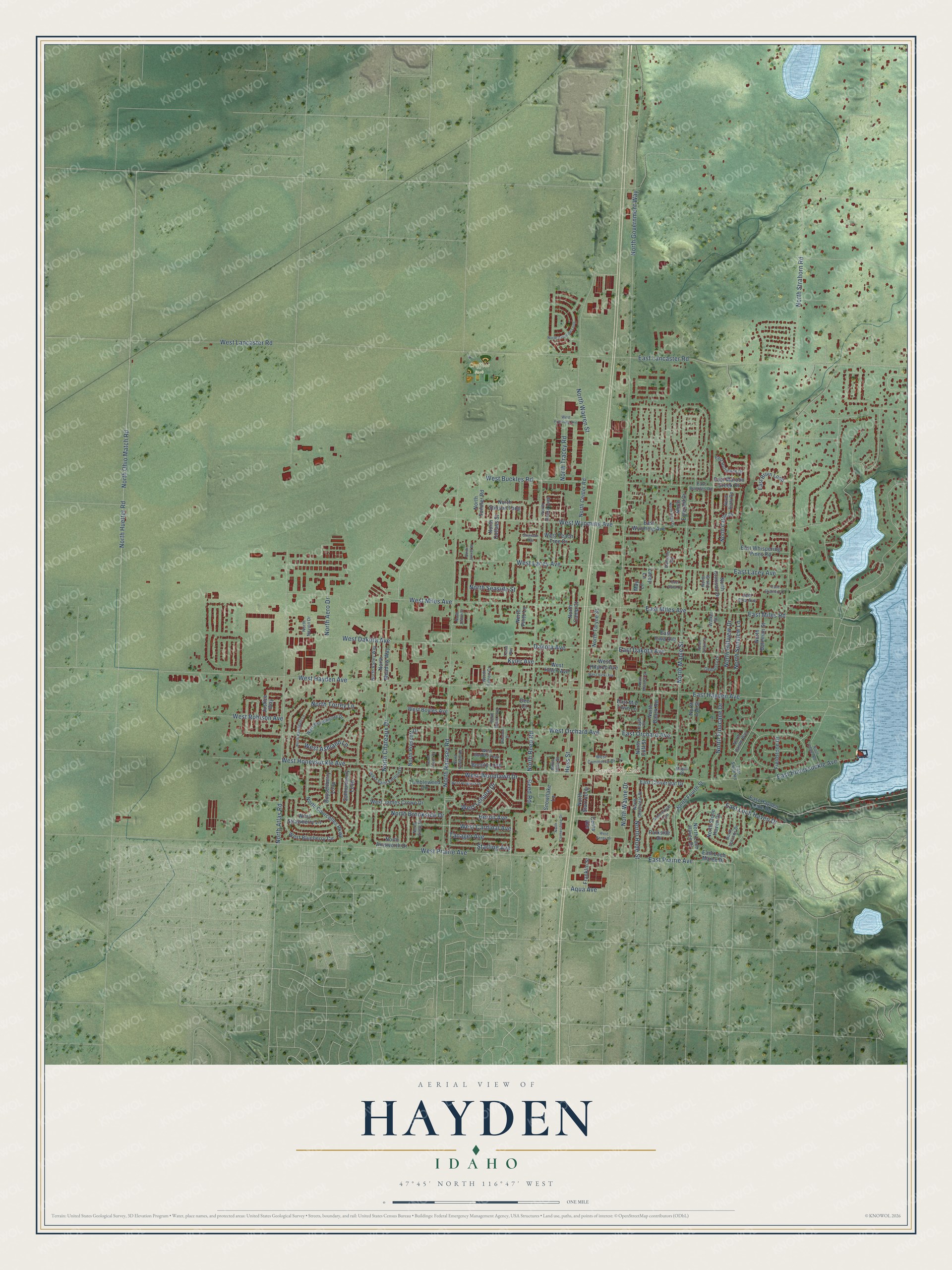
Hayden, Idaho Map Art
Building by building, with labeled streets and shaded relief.
12" x 18" Archival Matte Print
A Map of Home. A Work of Art.
Explore Hayden, Idaho from a whole new perspective. Created using aerial imagery and detailed geographic data, this map captures Hayden building by building, with labeled streets, familiar landmarks, and shaded topographical relief that highlights the natural contours of the landscape.
Combining modern data with the timeless character of a vintage atlas, this map is just as interesting up close as it is beautiful on the wall. Whether you grew up in Hayden, spent memorable years there, or call it home today, this unique map is a great way to celebrate a place that means something to you. Zoom in on the preview to look for your street, and then order a print to put your memories on the wall.
Three ways to hang it

Unframed archival matte, a black wood frame or a white wood frame.
Up close
Geography Worth Displaying
This map was created using accurate cartographic data and authoritative geographic sources, including the U.S. Geological Survey and the Census Bureau. The map brings together terrain, waterways, roads, and building detail. The majority of the streets are labeled, houses are accurately depicted, and the topography is derived from government sources. Combining local data with carefully composed color and shading leads to this beautifully detailed Hayden artwork for your wall.
Rather than simply showing street outlines, we’ve included as many of the street names as we could reasonably fit on the map while keeping their names legible. Zoom in on the high resolution preview to see exactly what’s on the map. We truly set out to create a statement piece for anyone who loves Hayden. So whether it’s for you, or a gift for someone you love, we hope this map of Hayden brings back fond memories.

Find your street
Names on the Hayden map
Every name below is printed on this map. Look for your street, your school, the park where you played, or the pond down the road.
Places and landmarks2
- Hayden City Hall
- Croffoot Park
Streets and roads150
- West Honeysuckle Avenue
- Heron Avenue
- East Loch Haven Drive
- North Government Way
- West Lancaster Road
- West Hayden Avenue
- West Prairie Avenue
- North Huetter Road
- North Atlas Road
- North Ramsey Road
- West Dakota Avenue
- North Reed Road
- North Strahorn Road
- North Maple Street
- North Ohio Match Road
- East Honeysuckle Avenue
- West Miles Avenue
- North Chateaux Drive
- West Orchard Avenue
- North Torrey Lane
- West Wyoming Avenue
- West Lacey Avenue
- East Lacey Avenue
- East Miles Avenue
- East Dakota Avenue
- North Warren Street
- West Woodlawn Drive
- East Lancaster Road
- East Hayden Avenue
- East Prairie Avenue
Show all 150 streets
- North Hillview Drive
- West Buckles Road
- West Cardinal Avenue
- North Finucane Drive
- North Wayne Drive
- West Leisure Drive
- North Rude Street
- North Brookside Drive
- Dakota Avenue
- North Sunview Lane
- West Ashland Lane
- North Tracey Road
- East Orchard Avenue
- Tanager Avenue
- North Seaside Street
- Starling Avenue
- West Robison Avenue
- East Miles Road
- Aqua Avenue
- Reed Road
- North Aero Drive
- Hess Street
- Kyler Avenue
- West Blueberry Circle
- North Cattle Drive
- North Courcelles Parkway
- North Stone Haven Drive
- North Ainsworth Drive
- North Fourth Street
- Salmonberry Loop
- East Wyoming Avenue
- Bounty Loop
- East Bruin Loop
- Tumbleweed Circle
- North Ash Street
- North Starr Loop
- Boysenberry Loop
- East Cloverleaf Drive
- North Stinson Loop
- East Whispering Pines Road
- West Peach Tree Drive
- West James Crowe Drive
- North Loch Haven Drive
- East Maroon Creek Drive
- North Baack Road
- West Strawberry Lane
- North Prescott Drive
- Parkside Drive
- North Center Road
- Centa Avenue
- North Emerald Drive
- Fieldstone Drive
- North Taryne Street
- North Crimson Drive
- Justice Way
- North Meadow Way
- North Sundler Road
- North Bateman Street
- West Boyles Avenue
- East Loch Maree Drive
- Snowflake Lane
- East Hayden Lake Road
- West Helen Avenue
- North Cutlass Street
- East Mid Town Lane
- North Camp Court
- Franklin Street
- East Iowa Avenue
- West Hilgren Avenue
- North Pinto Lane
- North Cuff Street
- Dee Court
- Lacey Lane
- May Lane
- West Broadmoore Drive
- West Bounty Loop
- North Alaska Loop
- West Saint Emilion Drive
- West Commerce Drive
- North Valley Way
- North Uplands Drive
- East Hurricane Drive
- North Cloverleaf Drive
- North Castle Way
- Danielle Road
- East Buckles Road
- Maple Place
- North Riata Road
- North Sally Street
- Dempsey Drive
- North Navion Drive
- North Eileen Court
- East Smith Road
- East Ezra Avenue
- North Oak Street
- Walker Street
- North Hess Street
- Kayla Court
- North Ramsgate Lane
- Summerfield Loop
- North Macie Loop
- West Centa Drive
- North Telluride Loop
- North Cornerstone Drive
- West Progress Drive
- Blossom Drive
- North Chalet Road
- West Fryeburg Avenue
- North Melrose Street
- North Beryl Drive
- West Vicki Avenue
- North Neufeld Road
- North Fitzue Drive
- East Stratford Drive
- North Jannel Street
- North Zenith Street
- North Justin Court
- Sheridan Avenue
- East Dana Court
- Tessa Way
Names are listed as they appear on the printed map. Zoom into the product photos to find them.
About Hayden, Idaho
Hayden is a city of 15,570 people in Kootenai County, at the southwestern end of Hayden Lake. The Coeur d'Alene tribe fished, hunted and picked huckleberries around the lake. Father DeSmet, a missionary to the tribe, was the first white visitor, and he called it Lake DeNuf. Settlers came in the 1870s for the good soil and timber, and Mat Heyden, a soldier from Fort Sherman, planted the area's first orchard on the western shore.
Cars later pulled the center of town away from the lake and the trolley line toward Government Way, which had become Highway 95 by the 1950s. Shops at its corner with Honeysuckle Avenue were known as Hayden Village. In 1955 the owners of Sargent's Restaurant were blocked from getting a liquor license by Idaho law. The village first tried to join the lakeshore town of Hayden Lake. When that failed, local leaders chose to incorporate, and the Village of Hayden began that year with 440 acres and about 700 people. Sargent's then got its license.
“Legend has it that Hayden and Hager, whose homestead was on the site of the present-day Hayden Lake Country Club, played a game of seven-up to determine who should name the lake. Hayden won the card game.”
- Sawmills and railroad tiesAround the turn of the century, Hayden Lake had no fewer than three sawmills working on its shores. One of them became part of the Atlas Tie Company, which sold railroad ties all over Idaho. In the early 20th century, steamboats on the lake carried goods for the mills and the towns along the shore.
- Two presidents at Bozanta TavernAvondale Cottage, a resort built in 1903 on part of John Hickey's land claim, was rebuilt by investors in 1906 as Bozanta Tavern. Spokane architect KK Cutter designed the hotel in a Swiss chalet style, and John Charles Olmsted laid out the grounds. A trolley line brought thousands of visitors from Spokane and Coeur d'Alene, and both Theodore Roosevelt and William Howard Taft came to see it.
- A school moved for a hotelWorkers began a schoolhouse on the lakeshore, but before it was done it was moved to make room for Bozanta Tavern. The building was finished closer to Government Way. In 1936 an Art Deco school went up on that site, and it is still standing.
- Sugar beets and cherry orchardsIn 1906 DC Corbin used the high tariff on sugar to his advantage, buying land north of Hayden and hiring Japanese workers to grow sugar beets. Poultry and dairy farms followed, the area's first fruit packing plant opened in 1914, and by the 1920s cherry and apple orchards covered the land. Cold winters in the 1930s killed many trees, and many of the orchards were never replanted.
Keep exploring Idaho
Hayden is one of 279 Idaho towns we've mapped. Every dot on the map is a print of its own.
The search covers every state, Idaho first.
Near Hayden
Order 2 or more town maps and save 10%. Shown in the size and finish you picked above, so they hang as a set.
- Hayden Lake 12" x 18" / Archival Matte Print $39.99
- Dalton Gardens 12" x 18" / Archival Matte Print $39.99
- Garwood 12" x 18" / Archival Matte Print $39.99


More maps nearby: Coeur d'Alene, Rathdrum, Huetter, Fernan Lake Village and Post Falls.
The art of mapping a place
How This Map Was Made
Real places. Remarkable detail. Discover the layers that turn geographic data into a map of home.

The view from above
Aerial imagery reveals the character of the land: woodland, open fields, and the patterns of a place.

The shape of the land
Elevation data brings hills, valleys, and subtle changes in the landscape into view.

The details of home
Roads, waterways, and building footprints come together to make the map feel unmistakably local.

Geography becomes art
Considered color, shading, and typography bring the layers together in a map made for your wall.


Process illustrated with Mendon, Massachusetts. Aerial imagery: USDA NAIP. Terrain: USGS 3D Elevation Program. Map details and finished artwork: KNOWOL.
The Details
About This Print
Choose an archival matte print, or a black or white Ayous wood frame. The archival matte print is unframed.
Select your size and finish above to see the matching product image and price.
Materials & Craftsmanship
A contemporary map with the character of a classic atlas, printed on archival matte paper. Optional frames are made from Ayous wood.
Your printed map does not include the watermark shown in the full-map preview.
Shipping & Delivery
Free shipping within the United States. Every print is made to order in the USA.
Buying a gift? Add a note in your cart and we'll include it. We never put prices in the package.
Prints ship within 2 to 3 business days. Allow 7 to 10 days total from ordering for delivery. Timing may vary during holidays or periods of high order volume.
Read our shipping policy.
Returns and damaged prints
Each print is made to order. Change-of-mind refunds are not available after production.
If your print arrives damaged, misprinted or incorrect, contact support@knowol.com within 30 days of receiving it. Include your order number, photos and a description of the issue.
Read our full refund and replacement policy. For questions about your order, email support@knowol.com.