
Search for another town


Free U.S. delivery 7 to 10 days after you order
Post Falls, Idaho Map Art
Building by building, with labeled streets and shaded relief.
12" x 18" Archival Matte Print
A Map of Home. A Work of Art.
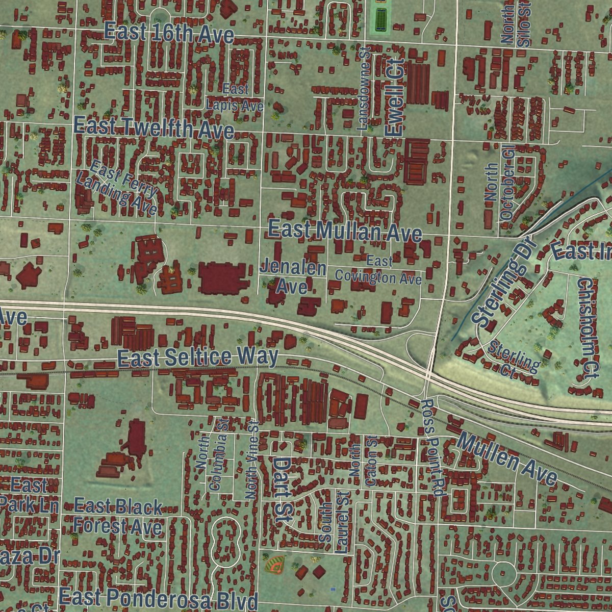
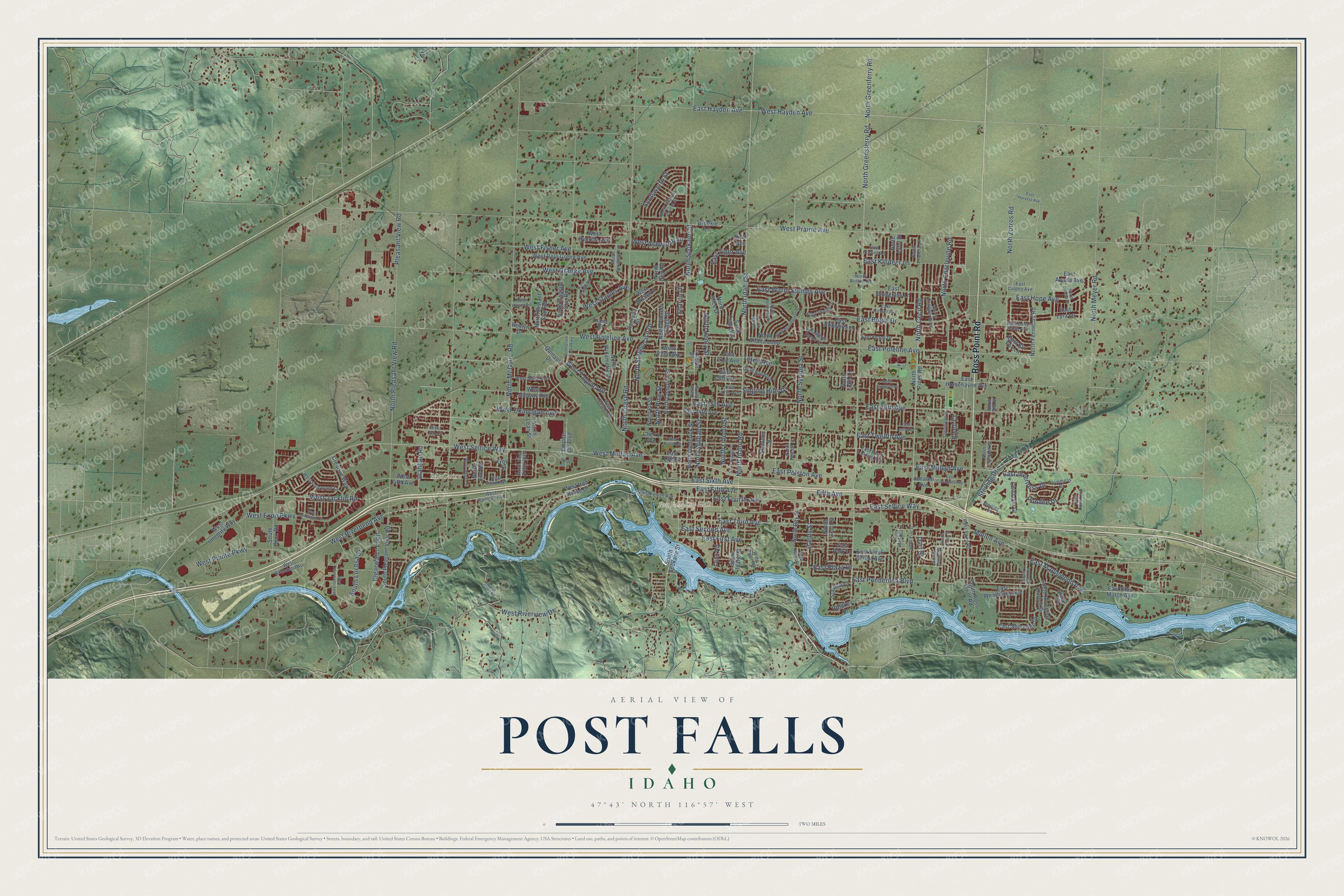
Explore Post Falls, Idaho from a whole new perspective. Created using aerial imagery and detailed geographic data, this map captures Post Falls building by building, with labeled streets, familiar landmarks, and shaded topographical relief that highlights the natural contours of the landscape.
Combining modern data with the timeless character of a vintage atlas, this map is just as interesting up close as it is beautiful on the wall. Whether you grew up in Post Falls, spent memorable years there, or call it home today, this unique map is a great way to celebrate a place that means something to you. Zoom in on the preview to look for your street, and then order a print to put your memories on the wall.
Three ways to hang it

Unframed archival matte, a black wood frame or a white wood frame.
Up close
Geography Worth Displaying
This map was created using accurate cartographic data and authoritative geographic sources, including the U.S. Geological Survey and the Census Bureau. The map brings together terrain, waterways, roads, and building detail. The majority of the streets are labeled, houses are accurately depicted, and the topography is derived from government sources. Combining local data with carefully composed color and shading leads to this beautifully detailed Post Falls artwork for your wall.
Rather than simply showing street outlines, we’ve included as many of the street names as we could reasonably fit on the map while keeping their names legible. Zoom in on the high resolution preview to see exactly what’s on the map. We truly set out to create a statement piece for anyone who loves Post Falls. So whether it’s for you, or a gift for someone you love, we hope this map of Post Falls brings back fond memories.
Read the story behind this map of Post Falls, Idaho from 2026.

Find your street
Names on the Post Falls map
Every name below is printed on this map. Look for your street, your school, the park where you played, or the pond down the road.
Places and landmarks2
- Post Falls City Hall
- McGuire
Streets and roads196
- Ross Point Road
- East Seltice Way
- West Seltice Way
- North Charleville Road
- East Maplewood Avenue
- Sterling Drive
- North William Street
- Idahline Road
- North Spokane Street
- East 16th Avenue
- East Fourth Avenue
- North Pine Street
- East Killdeer Lane
- West Prairie Avenue
- North Greensferry Road
- North Greenferry Road
- North Idaho Street
- East Poleline Avenue
- West Hayden Avenue
- East Mullan Avenue
- North Idaho Road
- East Bogie Drive
- East Third Avenue
- North McGuire Road
- East Hayden Avenue
- North Chase Road
- North Pleasant View Road
- East Twelfth Avenue
- West Poleline Avenue
- East Second Avenue
Show all 196 streets
- North Cecil Road
- North Henry Street
- East First Avenue
- East Hope Avenue
- West Grange Avenue
- North Lincoln Street
- Clearwater Loop
- West Expo Parkway
- North Syringa Street
- North Zorros Road
- West Riverbend Avenue
- West Fisher Avenue
- East Inverness Drive
- North Stagecoach Drive
- West Pointe Parkway
- West Jacklin Road
- East Ponderosa Boulevard
- East Polston Avenue
- West Riverview Drive
- West Mullan Avenue
- West Staples Avenue
- South Lochsa Street
- Pleasant View Road
- East Warm Springs Avenue
- Scotsworth Street
- West Okanogan Avenue
- West Ashworth Lane
- East 15th Avenue
- Singing Hills Drive
- Dundee Drive
- North Meyer Road
- East Sixth Avenue
- East Fifth Avenue
- East Tiger Avenue
- West Yaquina Drive
- Mullen Avenue
- East Plaza Drive
- Handy Street
- Fifth Avenue
- Sharon Drive
- Teton Avenue
- Ewell Court
- Dart Street
- East Horsehaven Avenue
- South Spokane Street
- West Iron Horse Drive
- West Fifth Avenue
- Sand Trap Way
- North Pines Road
- East Ohio Match Avenue
- North Compton Street
- North Alfalfa Loop
- South Riverside Harbor Drive
- North Frederick Street
- North Fennecus Road
- West Polo Green Avenue
- North Willamette Drive
- South Pleasant View Road
- South Beck Road
- East Shoreline Drive
- West Midway Avenue
- South Ross Point Road
- East Black Forest Avenue
- North Radiant Star Road
- East Weatherby Avenue
- East 14th Avenue
- East 21st Avenue
- Brookie Lane
- East Park Lane
- North Elm Road
- Sunrise Court
- Chisholm Court
- North Distant Star Road
- North Guy Road
- West 22nd Avenue
- Creative Way
- East Bobwhite Lane
- North Bay Street
- West Integrity Way
- North Lean Street
- West Hydrilla Avenue
- East 19th Avenue
- North Pioneer Ridge Drive
- South Idaho Street
- West Bridle Lane
- Empire Ctr Boulevard
- East Bluegrass Lane
- North Slice Drive
- East Aquila Avenue
- East Kit Fox Lane
- North Lynn Street
- North Fir Street
- Shannon Lane
- Coho Road
- North Luke Lane
- Rodkey Drive
- Divot Avenue
- Quinault Drive
- North Scott Street
- East Lyra Lane
- Railroad Street
- Shore Cv
- East 13th Street
- Roslyn Drive
- Jenalen Avenue
- Cherry Avenue
- Hana Street
- Troy Street
- West Railroad Avenue
- North Lucas Street
- Inverness Drive
- East White Sands Lane
- West Palmwood Lane
- Quail Run Boulevard
- North Britton Road
- East Thrush Drive
- East Early Dawn Avenue
- West Fourth Avenue
- West Dawn Avenue
- West Tualatin Drive
- West Grassland Avenue
- East Ferry Landing Avenue
- West Malad Avenue
- North Pradera Lane
- East Knapp Drive
- North Oconner Boulevard
- North Crown Pointe Street
- North Ivy Lane
- North Serenity Avenue
- North October Gl
- East Culpeo Avenue
- Wide River Road
- North King Arthur Boulevard
- East Corrine Lane
- North Tuscon Street
- East Cinder Avenue
- East 17th Avenue
- West Elk Drive
- South Laurel Street
- Sterling Court
- North Silo Street
- North Bill Street
- South Cedar Street
- West Clearwater Loop
- North Howell Road
- West Gumwood Circle
- North Coles Loop
- North Bunchgrass Drive
- North Viking Loop
- South Curvy Road
- West Staples Road
- North Clark Fork Parkway
- East Covington Avenue
- North Vine Street
- North Brigger Street
- North Megan Street
- North Tucana Street
- Lansdowne Street
- East Harvest Avenue
- North Dandelion Street
- North Columbia Street
- West Tenth Avenue
- East Lapis Avenue
- Park Wood Place
- North Caton Street
- Griffin Street
Names are listed as they appear on the printed map. Zoom into the product photos to find them.
About Post Falls, Idaho
Post Falls is a city of 38,485 people in Kootenai County, on the Rathdrum Prairie between the Spokane River and the Washington state line. In 1871 Frederick Post, who had come to America from Germany, bought land beside the river from the Coeur d'Alene Tribe's leader, Chief Andrew Seltice. Post put up a lumber mill on that land, and the town that grew around it took his name.
- Treaty RockThe sale of the land by Chief Andrew Seltice to Frederick Post is recorded in a pictograph on a granite cliff. The cliff now stands in Treaty Rock Park, and Treaty Rock joined the National Register in 1992.
- The county's only flour millThe Dart Brothers built a flouring mill at Post Falls in 1889. When An Illustrated History of North Idaho came out in 1903, it was still the only one in all of Kootenai County.
- From timber to knivesKootenai County long made its living from timber. In more recent years Buck Knives moved its manufacturing headquarters to Post Falls, bringing a workforce of 250.
Keep exploring Idaho
Post Falls is one of 279 Idaho towns we've mapped. Every dot on the map is a print of its own.
The search covers every state, Idaho first.
Near Post Falls
Order 2 or more town maps and save 10%. Shown in the size and finish you picked above, so they hang as a set.
- Hauser 12" x 18" / Archival Matte Print $39.99
- State Line 12" x 18" / Archival Matte Print $39.99
- Huetter 12" x 18" / Archival Matte Print $39.99


More maps nearby: Rathdrum, Coeur d'Alene, Hayden, Dalton Gardens and Hayden Lake.
The art of mapping a place
How This Map Was Made
Real places. Remarkable detail. Discover the layers that turn geographic data into a map of home.

The view from above
Aerial imagery reveals the character of the land: woodland, open fields, and the patterns of a place.

The shape of the land
Elevation data brings hills, valleys, and subtle changes in the landscape into view.

The details of home
Roads, waterways, and building footprints come together to make the map feel unmistakably local.

Geography becomes art
Considered color, shading, and typography bring the layers together in a map made for your wall.


Process illustrated with Mendon, Massachusetts. Aerial imagery: USDA NAIP. Terrain: USGS 3D Elevation Program. Map details and finished artwork: KNOWOL.
The Details
About This Print
Choose an archival matte print, or a black or white Ayous wood frame. The archival matte print is unframed.
Select your size and finish above to see the matching product image and price.
Materials & Craftsmanship
A contemporary map with the character of a classic atlas, printed on archival matte paper. Optional frames are made from Ayous wood.
Your printed map does not include the watermark shown in the full-map preview.
Shipping & Delivery
Free shipping within the United States. Every print is made to order in the USA.
Buying a gift? Add a note in your cart and we'll include it. We never put prices in the package.
Prints ship within 2 to 3 business days. Allow 7 to 10 days total from ordering for delivery. Timing may vary during holidays or periods of high order volume.
Read our shipping policy.
Returns and damaged prints
Each print is made to order. Change-of-mind refunds are not available after production.
If your print arrives damaged, misprinted or incorrect, contact support@knowol.com within 30 days of receiving it. Include your order number, photos and a description of the issue.
Read our full refund and replacement policy. For questions about your order, email support@knowol.com.