


Search for another town


Free U.S. delivery 7 to 10 days after you order
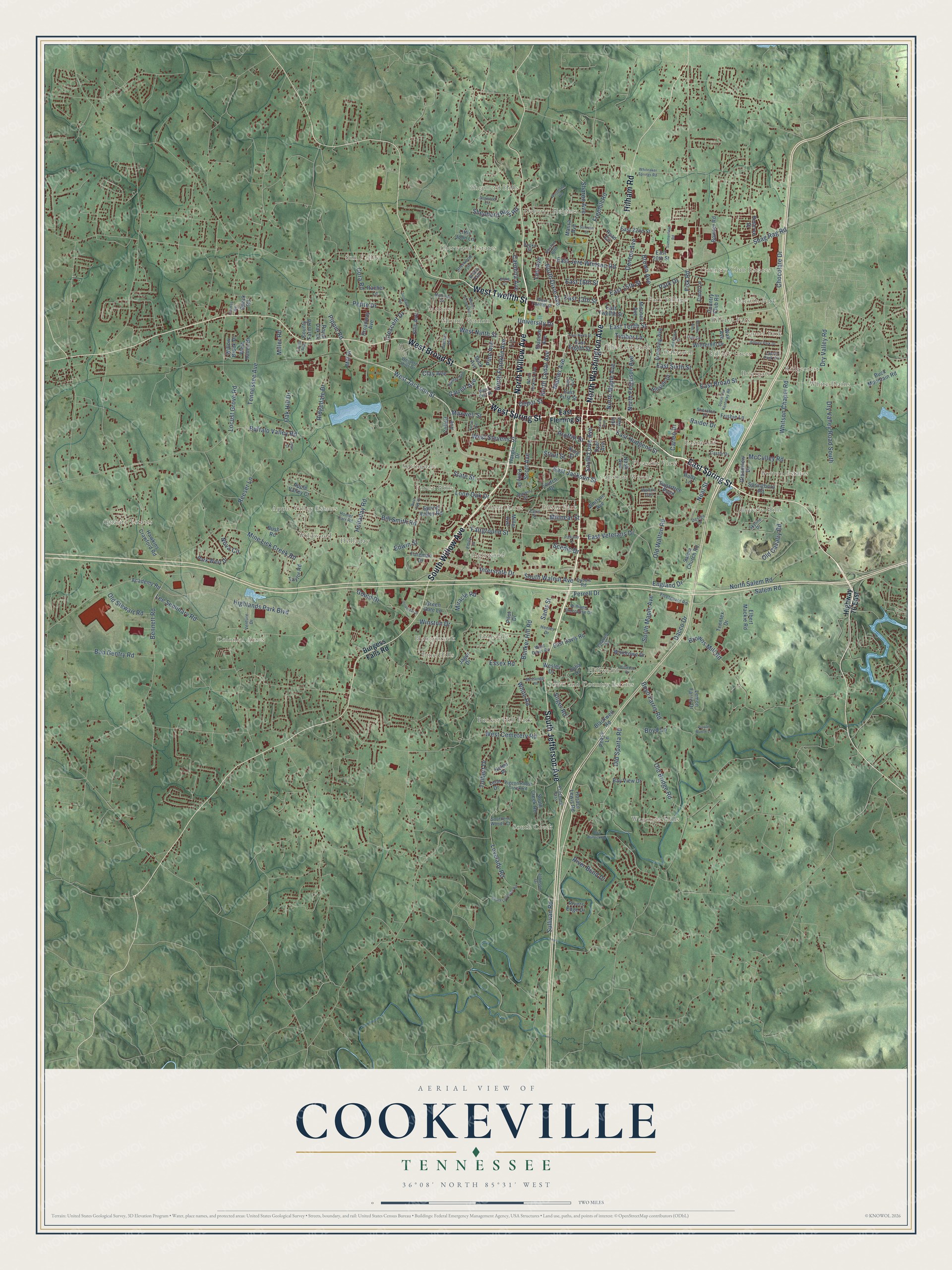
Cookeville, Tennessee Map Art
Building by building, with labeled streets and shaded relief.
12" x 18" Archival Matte Print
A Map of Home. A Work of Art.
Explore Cookeville, Tennessee from a whole new perspective. Created using aerial imagery and detailed geographic data, this map captures Cookeville building by building, with labeled streets, familiar landmarks, and shaded topographical relief that highlights the natural contours of the landscape.
Combining modern data with the timeless character of a vintage atlas, this map is just as interesting up close as it is beautiful on the wall. Whether you grew up in Cookeville, spent memorable years there, or call it home today, this unique map is a great way to celebrate a place that means something to you. Zoom in on the preview to look for your street, and then order a print to put your memories on the wall.
Three ways to hang it

Unframed archival matte, a black wood frame or a white wood frame.
Up close
Geography Worth Displaying
This map was created using accurate cartographic data and authoritative geographic sources, including the U.S. Geological Survey and the Census Bureau. The map brings together terrain, waterways, roads, and building detail. The majority of the streets are labeled, houses are accurately depicted, and the topography is derived from government sources. Combining local data with carefully composed color and shading leads to this beautifully detailed Cookeville artwork for your wall.
Rather than simply showing street outlines, we’ve included as many of the street names as we could reasonably fit on the map while keeping their names legible. Zoom in on the high resolution preview to see exactly what’s on the map. We truly set out to create a statement piece for anyone who loves Cookeville. So whether it’s for you, or a gift for someone you love, we hope this map of Cookeville brings back fond memories.
Read the story behind this map of Cookeville, Tennessee from 2026.

Find your street
Names on the Cookeville map
Every name below is printed on this map. Look for your street, your school, the park where you played, or the pond down the road.
Places and landmarks40
- Ensor Park
- Country Club Estates
- Colonial Acres
- Wagonda Hills
- Sherwood Estates
- Burton Estates
- Holladay
- Hillwood
- Village Green
- Pleasant View
- Deberry Heights
- Quality Estates
Show all 40 places
- Bunker Hill Park
- Tanglewood
- South Creek
- Sun Valley
- The Lowlands
- Springdale
- Hillsdale
- Mount Vernon
- White Plains
- Beverly Hills
- Pine Hills
- Eastwood
- Green Acres
- Park Village
- Laurel Park
- Shepherd Hills
- Capshaw Woods
- Town and Country Estates
- Oaklawn
- Darwin Park
- Apple Valley Estates
- Wildwood
- Ridgecrest
- Bilbrey Park
- Forest Hills
- Briargate
- Honeybrook
- Melrose
Streets and roads245
- East Spring Street
- West Spring Street
- West Broad Street
- North Washington Avenue
- West Twelfth Street
- South Jefferson Avenue
- North Willow Avenue
- South Willow Avenue
- Hilham Road
- South Walnut Avenue
- South Lowe Avenue
- East Jackson Street
- West Jackson Street
- East Broad Street
- North Dixie Avenue
- Neal Street
- Depot Street
- East Veterans Drive
- Crescent Drive
- East Tenth Street
- Bunker Hill Road
- Buffalo Valley Road
- Mine Lick Creek Road
- South Maple Avenue
- Tennessee Avenue
- Interstate Drive
- Fisk Road
- Lee Seminary Road
- Salem Road
- Old Sparta Road
Show all 245 streets
- Holladay Road
- North Maple Avenue
- Highlands Park Boulevard
- Boyd Farris Road
- Fairground Street
- Bill Smith Road
- Dry Valley Road South
- Brown Avenue
- East Hudgens Street
- Reeser Lane
- Locust Grove Road
- Whitson Chapel Road
- East Sixth Street
- North Salem Road
- Shag Rag Road
- North Franklin Avenue
- Old Bridge Road
- Denton Avenue
- Old Walton Road
- Lovelady Road
- Mahler Avenue
- East Jere Whitson Road
- West Ninth Street
- Ridgedale Drive
- Bennett Road
- Bob Gentry Road
- West Stevens Street
- University Drive
- River Bend Drive
- Old Cavalry Road
- East 15th Street
- Scott Avenue
- Park Drive
- Gould Drive
- Chocolate Drive
- Freehill Road
- Cora Road
- Lone Oak Drive
- Sliger Road
- West Cemetery Road
- Raider Drive
- Pine Avenue
- Essex Road
- Tolbert Drive
- East 13th Street
- State Street
- Proffitt Street
- White Road
- Dry Valley Road
- North Ferguson Avenue
- Browns Mill Road
- Old Stewart Road
- Shepherd Hills Road
- England Drive
- Sharon Avenue
- Winston Drive
- North Cedar Avenue
- McCulley Road
- Nova Circle
- Miracle Road
- East 16th Street
- Oak Hill Drive
- Carolina Avenue
- Garrett Avenue
- Scenic Drive
- Ferrell Drive
- Sullivan Road
- Lee Avenue
- Petite Drive
- Maxwell Street
- Sams Street
- Clay Avenue
- Boyd Lane
- Carlen Drive
- Miller Road
- Minnear Street
- Dacco Drive
- Stout Street
- Timber Lane
- Pippin Road
- Edwin Street
- East Fleming Street
- Burgess Falls Road
- Highway 70 East
- East Twelfth Street
- Foreman Drive
- Nash Avenue
- Buck Mountain Road
- Julia Drive
- Whitson Avenue
- Bay View Drive
- Park West Drive
- Pilot Drive
- South Creek Road
- Horace Lewis Road
- Lemon Farris Drive
- Apple Valley Court
- Bowser Road
- Windrowe Drive
- East 20th Street
- East First Street
- Foutch Drive
- Polly Drive
- Salem Church Road
- Hawkins Crawford Road
- Stadium Avenue
- Massa Avenue
- Little John Lane
- Wall Avenue
- Elbert Mackie Road
- East Eighth Street
- West Haven Drive
- Broadway Avenue
- Breeding Avenue
- Country Club Road
- Rivers Edge Drive
- Grandview Drive
- Winterhill Drive
- East Davis Road
- Spring Valley Road
- Peace Lane
- Sugartree Point
- Hillside Drive
- Ruby Lane
- Taylor Road
- Blackwell Road
- Springboro Road
- East 22nd Street
- Mitchell Avenue
- Ryan Circle
- Royal Oak Drive
- Tenntex Drive
- Academy Road
- Ellis Avenue
- Frisbie Lane
- Bush Road
- Reserve Drive
- Willow Brook Drive
- Green Gate Lane
- County Farm Road
- Leon Drive
- Hargis Drive
- Dyer Avenue
- Carol Lane
- Wesley Drive
- Rachel Lane
- Mill Drive
- Buck Avenue
- Coffelt Avenue
- King Street
- Speck Road
- Miller Avenue
- Jager Drive
- Helen Place
- Hill Avenue
- Bridle Path
- Skyline Drive
- Charles Street
- Pigeon Roost Creek Road
- Fleetguard Road
- Melrose Drive
- Sherwood Lane
- Laurel Park Circle
- West End Street
- Paris Street
- Emily Lane
- North Hickory Avenue
- Hunter Avenue
- Southern Woods Court
- Homer Carr Road
- Williams Enterprise Drive
- Walton Trail
- West Davis Road
- Darwin Street
- Venture Drive
- Sheraton Drive
- Castle Drive
- Pritchard Pass
- Johnson Drive
- Dubois Road
- Bouton Bnd
- Western Hills Drive
- Cooke Street
- Henley Drive
- Design Drive
- Louis Avenue
- South Old Kentucky Road
- Hillwood Drive
- West Oak Drive
- Summerfield Road
- Mount Vernon Road
- Dogwood Circle
- Bilbrey Park Drive
- Woodland Heights
- South Lovelady Road
- East Ninth Street
- Palkway Drive
- Whiteaker Springs Road
- Goodwin Road
- Messenger Road
- Blake Circle
- Universal Drive
- Bob Bullock Road
- Sullivan Street
- Purple Martin Lane
- Kacie Avenue
- Braswell Avenue
- Flatt Circle
- Oaklawn Court
- Holly Avenue
- Jean Court
- Thomas Road
- Locust Avenue
- Shanks Avenue
- Joy Drive
Names are listed as they appear on the printed map. Zoom into the product photos to find them.
About Cookeville, Tennessee
Cookeville is a city of 34,842 people and the county seat of Putnam County, on the Highland Rim. The Cherokee hunted this country until the Treaty of Tellico, signed in October 1805, ended their claims. Settlers then came in on Avery's Trace, known locally as the Walton Road. Putnam County was first formed in 1842. When a new state law set it up again in 1854, it needed a county seat. Leaders chose land bought by Charles Crook because its springs could supply a town. They named the town for Richard Fielding Cooke, who had settled nearby in 1810, served two terms in the state senate and helped create the county.
The Civil War split Cookeville. Most residents opposed secession, yet local men joined both armies, and the county courthouse on the square was burned. Bad feeling between neighbors and families held the town back for years. Growth returned after the Isbell, its first hotel, opened in 1886, and the Nashville and Knoxville Railroad arrived in 1890. Cookeville was chartered as a city in 1903.
- A depot saved in 1985The Tennessee Central built the Cookeville Depot in the West Side District in 1909, and passenger trains stopped there until 1955. The empty building then fell apart. Local residents and preservationists kept it from being torn down, and the city bought it. They restored the depot and opened it as a railroad museum in 1985, the same year it joined the National Register.
- From Dixie College to Tennessee TechLocal religious leaders started Dixie College in 1909 with help from the state. Students and money fell off, so the state took over the school in 1915. It reopened as Tennessee Polytechnic Institute, teaching science, engineering and mathematics. It was renamed Tennessee Technological University in 1965, and its growth made Cookeville a college town.
- John's Place since 1949This grocery and restaurant at 11 Gibson Avenue opened as Ed's Place in 1949. It later became McClellan's Cafe and took the name John's Place in 1957. In the Jim Crow years it was a place where white and black residents could eat together over fried chicken, catfish, meatloaf and corn bread. It joined the National Register in 2011.
- The Hub CityBy 1928 Cookeville was calling itself the Hub of the Upper Cumberland. U.S. Route 70N, its first modern highway, was finished by 1930. The city and the Civil Works Administration split the cost of an airport in 1934, and Interstate 40 was completed south of downtown by 1966.
Keep exploring Tennessee
Cookeville is one of 640 Tennessee towns we've mapped. Every dot on the map is a print of its own.
The search covers every state, Tennessee first.
Near Cookeville
Order 2 or more town maps and save 10%. Shown in the size and finish you picked above, so they hang as a set.
- Algood 12" x 18" / Archival Matte Print $39.99
- Baxter 12" x 18" / Archival Matte Print $39.99
- Dodson Branch 12" x 18" / Archival Matte Print $39.99


More maps nearby: Monterey, Cassville, Sparta, Rickman and Gainesboro.
The art of mapping a place
How This Map Was Made
Real places. Remarkable detail. Discover the layers that turn geographic data into a map of home.

The view from above
Aerial imagery reveals the character of the land: woodland, open fields, and the patterns of a place.

The shape of the land
Elevation data brings hills, valleys, and subtle changes in the landscape into view.

The details of home
Roads, waterways, and building footprints come together to make the map feel unmistakably local.

Geography becomes art
Considered color, shading, and typography bring the layers together in a map made for your wall.


Process illustrated with Mendon, Massachusetts. Aerial imagery: USDA NAIP. Terrain: USGS 3D Elevation Program. Map details and finished artwork: KNOWOL.
The Details
About This Print
Choose an archival matte print, or a black or white Ayous wood frame. The archival matte print is unframed.
Select your size and finish above to see the matching product image and price.
Materials & Craftsmanship
A contemporary map with the character of a classic atlas, printed on archival matte paper. Optional frames are made from Ayous wood.
Your printed map does not include the watermark shown in the full-map preview.
Shipping & Delivery
Free shipping within the United States. Every print is made to order in the USA.
Buying a gift? Add a note in your cart and we'll include it. We never put prices in the package.
Prints ship within 2 to 3 business days. Allow 7 to 10 days total from ordering for delivery. Timing may vary during holidays or periods of high order volume.
Read our shipping policy.
Returns and damaged prints
Each print is made to order. Change-of-mind refunds are not available after production.
If your print arrives damaged, misprinted or incorrect, contact support@knowol.com within 30 days of receiving it. Include your order number, photos and a description of the issue.
Read our full refund and replacement policy. For questions about your order, email support@knowol.com.