


Search for another town


Free U.S. delivery 7 to 10 days after you order
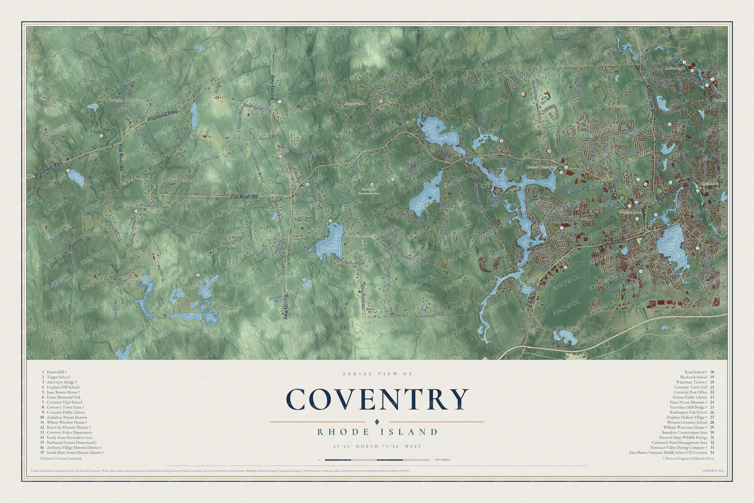
Coventry, Rhode Island Map Art
Building by building, with labeled streets and shaded relief.
12" x 18" Archival Matte Print
A Map of Home. A Work of Art.
Explore Coventry, Rhode Island from a whole new perspective. Created using aerial imagery and detailed geographic data, this map captures Coventry building by building, with labeled streets, familiar landmarks, and shaded topographical relief that highlights the natural contours of the landscape.
Combining modern data with the timeless character of a vintage atlas, this map is just as interesting up close as it is beautiful on the wall. Whether you grew up in Coventry, spent memorable years there, or call it home today, this unique map is a great way to celebrate a place that means something to you. Zoom in on the preview to look for your street, and then order a print to put your memories on the wall.
Three ways to hang it

Unframed archival matte, a black wood frame or a white wood frame.
Up close
Geography Worth Displaying
This map was created using accurate cartographic data and authoritative geographic sources, including the U.S. Geological Survey (USGS) and FEMA. The map brings together terrain, waterways, roads, and building detail. The majority of the streets are labeled, houses are accurately depicted, and the topography is derived from government sources. Combining local data with carefully composed color and shading leads to this beautifully detailed Coventry artwork for your wall.
Rather than simply showing street outlines, we’ve included as many of the street names as we could reasonably fit on the map while keeping their names legible. Zoom in on the high resolution preview to see exactly what’s on the map. We truly set out to create a statement piece for anyone who loves Coventry. So whether it’s for you, or a gift for someone you love, we hope this map of Coventry brings back fond memories.
Explore the full map of Coventry, Rhode Island and read about the local places it shows.

Find your street
Names on the Coventry map
Every name below is printed on this map. Look for your street, your school, the park where you played, or the pond down the road.
Places and landmarks13
- Coventry Town Hall
- Greene
- Quidnick
- Arkwright
- Beaudoin Conservation Area
- Hopkins Hollow
- Vernon
- Potterville
- Colvintown
- Vaughn Hollow
- Gortons Corner
- Washington
Show all 13 places
- Phenix
Streets and roads217
- Plainfield Pike
- Flat River Road
- Victory Highway
- Tiogue Avenue
- Knotty Oak Road
- Main Street
- Washington Street
- Perry Hill Road
- Hill Street
- Kiley Way
- Arbor Drive
- Island Drive
- Linda Drive
- Arnold Road
- Harkney Hill Road
- Hill Farm Road
- Town Farm Road
- Fish Hill Road
- Colvintown Road
- Sisson Road
- Phillips Hill Road
- Hopkins Hollow Road
- Narrow Lane
- Whaley Hollow Road
- Carrs Trail
- Weaver Hill Road
- Nicholas Road
- Read School House Road
- Gibson Hill Road
- Hammet Road
Show all 217 streets
- Lewis Farm Road
- Greenhouse Road
- Hopkins Hill Road
- Blackrock Road
- Station Street
- Wood Cove Drive
- Hope Furnace Road
- Waterman Hill Road
- Fairview Avenue
- Reservoir Road
- Cahoone Road
- Franklin Road
- Teakwood Drive
- Susan Bowen Road
- Wisteria Drive
- Ledge Road
- Read Avenue
- Fieldstone Drive
- Matteson Road
- Ginger Trail
- Newport Road
- Rice City Road
- John Franklin Road
- New London Turnpike
- Barbs Hill Road
- Hunters Crossing
- Sand Hill Road
- Chaplin Drive
- Boston Street
- Pilgrim Avenue
- Mile Road
- Walker Lane
- Old North Road
- Tillinghast Road
- Molasses Hill Road
- Log Bridge Road
- Macarthur Boulevard
- Club House Road
- Old Flat River Road
- Provident Place
- Clark Road
- Casey Lane
- Piggy Lane
- Leuba Road
- Hornbeam Road
- Quidnick Street
- Watercress Court
- Lear Drive
- Red Oak Drive
- Weeks Hill Road
- Arrowwood Road
- Gervais Street
- Bowen Hill Road
- Indian Trail
- Gentry Farm Road
- Pig Hill Road
- Clark Mill Street
- York Drive
- Potter Road
- Sharon Drive
- Airport Road
- Lydia Road
- Raven Boulevard
- Rock Hill Road
- Great Road
- Hall Road
- Maple Street
- Metro Drive
- Clover Drive
- Benoit Street
- Lori Lane
- Taft Street
- Lynn Drive
- Sheltra Avenue
- Fairway Drive
- Maple Valley Road
- Hill Farm Camp Road
- Twin Brook Lane
- East Shore Drive
- Camp Westwood Road
- Shady Valley Road
- South Main Street
- Richardson Road
- Pinehaven Road
- Audubon Lane
- Princeton Avenue
- Tiffany Road
- Howard Avenue
- Highwood Drive
- Vaughn Hollow Road
- Bramble Bush Road
- Acres of Pine Road
- Dante Boulevard
- Helen Avenue
- West Log Bridge Road
- Victory Falls Road
- Northup Plat Road
- Abbotts Crossing Road
- Leisure Way
- David Drive
- Silver Maple Drive
- Nike Site Road
- Juniper Hill Drive
- Aster Lane
- Stone Gate Drive
- Fen Way
- Pine Tree Road
- Kivranta Drive
- Rock Pine Road
- Pulaski Street
- Harrington Road
- Allison Avenue
- Harris Street
- Doe Run
- Alvero Road
- Angus Street
- Grant Drive
- Maple Root Road
- Lionel Avenue
- Nichole Lane
- Stuart Drive
- Country View Drive
- Park Avenue
- Lane East
- Ames Street
- Potter Court
- Battey Avenue
- Edith Street
- Jenks Road
- Phillip Street
- Windy Hill Lane
- Idaho Street
- Ian Street
- Williams Crossing Road
- Cobblestone Terrace
- Ironwood Drive
- Woodmist Circle
- Poor Farm Road
- Laurel Avenue
- Scott Hollow Road
- Wood Street
- Torch Lane
- Hazard Street
- Catalpa Way
- Big River Road
- Apple Blossom Lane
- Paige Drive
- Meredith Drive
- Hillside Avenue
- Mason Street
- Viola Street
- Jade Road
- New Dam Road
- October Trail
- Benefit Street
- Gibson Lane
- Rhema Way
- Oak Road
- Gay Street
- Sherwood Valley Lane
- Pembroke Lane
- Remington Farm Drive
- South Pond Drive
- Old Carriage Drive
- Black Walnut Drive
- Angelina Drive
- Old Summit Road
- Lionel Pierson Road
- Jefferson Drive
- Shippee Plat Road
- Weymouth Ridge
- Sunset Lake Circle
- Marion Drive
- Ridgewood Trail
- King Street
- Rainone Court
- Park Lane
- Leslie Lane
- Industrial Drive
- Circle Drive
- Railroad Avenue
- Wilshire Way
- Gareau Drive
- Regent Street
- Cheryl Lane
- Pine Street
- Vine Street
Names are listed as they appear on the printed map. Zoom into the product photos to find them.
About Coventry, Rhode Island
Coventry is a town of 35,688 people in Kent County, reaching from West Warwick all the way west to the Connecticut line. The first English colonists farmed this ground early in the 18th century, back when it was a remote corner of Warwick. By 1741 roughly 100 families had settled, so they petitioned the General Assembly for a separate town. The Assembly agreed, and the new town was named for Coventry in England.
Mills changed the east end in the 19th century. William and Richard Anthony opened a textile mill in 1805 in the Quaker village that took their name, and more factories followed at Washington, Quidnick and Harris. The work drew French Canadian and Irish families, and by the end of the 1800s almost a fourth of Coventry's people had been born abroad. French became the everyday language in much of eastern Coventry.
- General Greene's home, 1770Nathanael Greene was living in Coventry as the Revolution started, and he ended the war as second in command to George Washington. In 1770 he built Spell Hall at 50 Taft Street on 2,000 acres, and he kept more than 300 books in its front room. The Greene family held the house until 1899. Restorers organized in 1919, and they opened it as a museum in 1924.
- The 7:25 milk trainGreene was only a swamp crossed by a cart path until the railroad came in the early 1850s. The stop began as Coffin Station, and in 1856 the railroad renamed it for the general. Farmers met the 7:25 train to Providence with milk, and the village also shipped wood and cranberries. From 1880 Advent Christian camp meetings drew as many as 10,000 people. The depot closed in 1969, and the rail bed became the 15 mile Coventry Greenway.
- An iron truss from 1888The Dean and Westbrook firm built the Arkwright Bridge in 1888, paid for by the town and the Interlaken Mills, to carry Hill Street across the Pawtuxet River where it divides Coventry from Cranston. The iron truss runs 128 feet, 6 inches, and it was added to the National Register in 1978. The two communities shut it to traffic in 2011, and it has sat unused since then.
- The town poor farmJoseph Briggs built his farmhouse around 1790. In 1851 Coventry bought it from his heirs to house and feed the town's poor, and the farm served that purpose into the 1930s. It survives as the Joseph Briggs House, or Coventry Town Farm, and is now a two-family home.
- A tavern for Connecticut travelersRice Tavern opened in 1804 on Plainfield Pike, in the northwest corner of town, to serve travelers heading to Connecticut. Rice City grew up around it, stretching for several miles along the road, and in 1846 the village gained a church. The Rice City Historic District has been listed on the National Register since 1980.
Keep exploring Rhode Island
Coventry is one of 86 Rhode Island towns we've mapped. Every dot on the map is a print of its own.
The search covers every state, Rhode Island first.
Near Coventry
Order 2 or more town maps and save 10%. Shown in the size and finish you picked above, so they hang as a set.
- Greene 12" x 18" / Archival Matte Print $39.99
- West Greenwich 12" x 18" / Archival Matte Print $39.99
- Washington 12" x 18" / Archival Matte Print $39.99


More maps nearby: Hope, Clayville, Foster Center, Foster and West Warwick.
The art of mapping a place
How This Map Was Made
Real places. Remarkable detail. Discover the layers that turn geographic data into a map of home.

The view from above
Aerial imagery reveals the character of the land: woodland, open fields, and the patterns of a place.

The shape of the land
Elevation data brings hills, valleys, and subtle changes in the landscape into view.

The details of home
Roads, waterways, and building footprints come together to make the map feel unmistakably local.

Geography becomes art
Considered color, shading, and typography bring the layers together in a map made for your wall.


Process illustrated with Mendon, Massachusetts. Aerial imagery: USDA NAIP. Terrain: USGS 3D Elevation Program. Map details and finished artwork: KNOWOL.
The Details
About This Print
Choose an archival matte print, or a black or white Ayous wood frame. The archival matte print is unframed.
Select your size and finish above to see the matching product image and price.
Materials & Craftsmanship
A contemporary map with the character of a classic atlas, printed on archival matte paper. Optional frames are made from Ayous wood.
Your printed map does not include the watermark shown in the full-map preview.
Shipping & Delivery
Free shipping within the United States. Every print is made to order in the USA.
Buying a gift? Add a note in your cart and we'll include it. We never put prices in the package.
Prints ship within 2 to 3 business days. Allow 7 to 10 days total from ordering for delivery. Timing may vary during holidays or periods of high order volume.
Read our shipping policy.
Returns and damaged prints
Each print is made to order. Change-of-mind refunds are not available after production.
If your print arrives damaged, misprinted or incorrect, contact support@knowol.com within 30 days of receiving it. Include your order number, photos and a description of the issue.
Read our full refund and replacement policy. For questions about your order, email support@knowol.com.