


Search for another town


Free U.S. delivery 7 to 10 days after you order
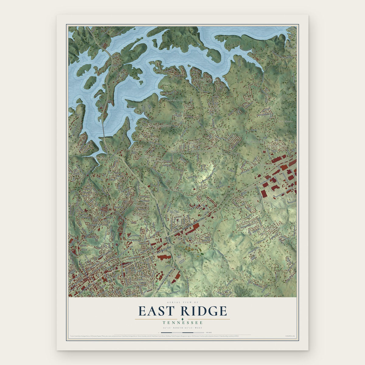
East Ridge, Hamblen County, Tennessee Map Art
Building by building, with labeled streets and shaded relief.
12" x 18" Archival Matte Print
A Map of Home. A Work of Art.
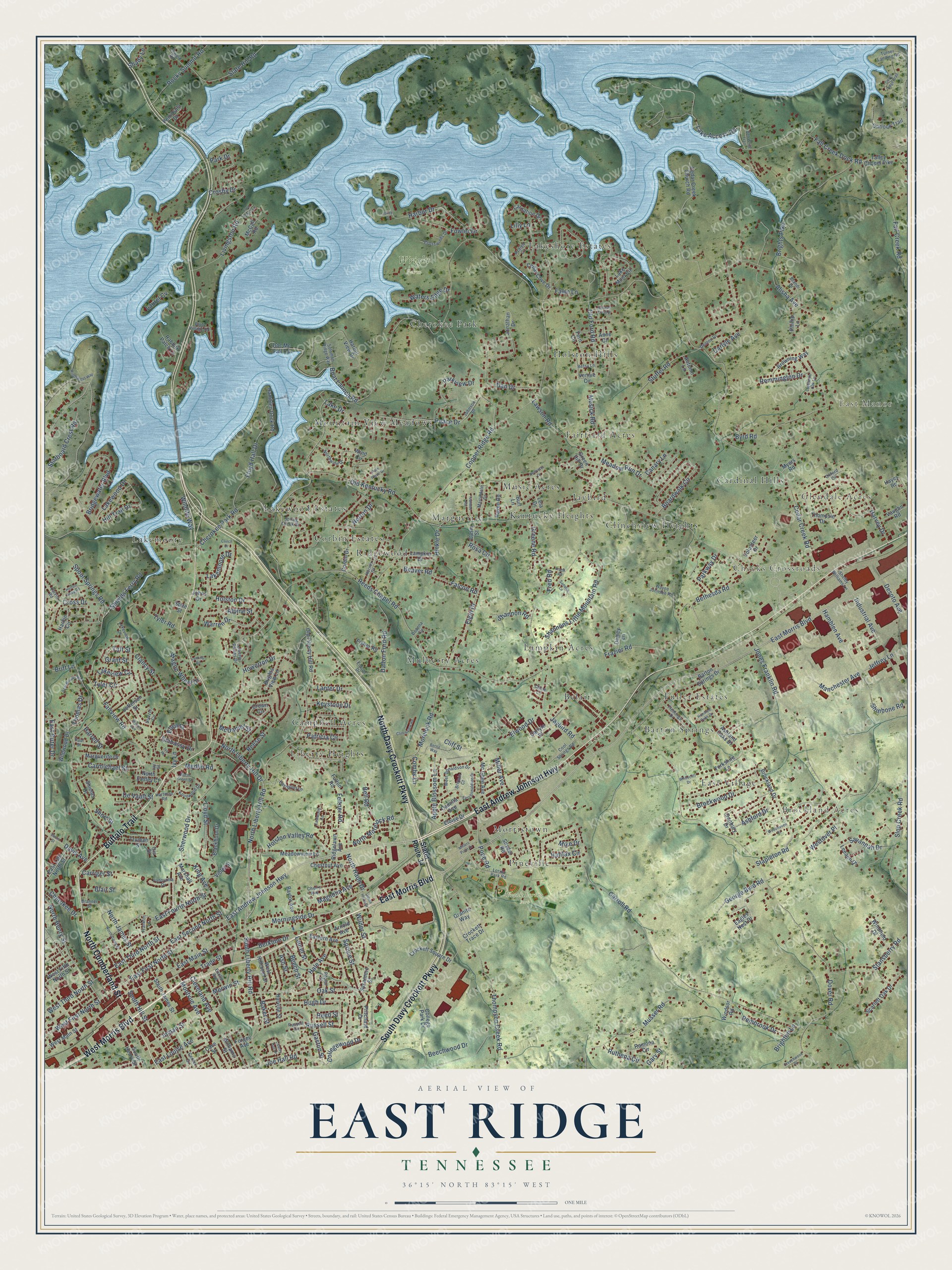
Explore East Ridge, Tennessee from a whole new perspective. Created using aerial imagery and detailed geographic data, this map captures East Ridge building by building, with labeled streets, familiar landmarks, and shaded topographical relief that highlights the natural contours of the landscape.
Combining modern data with the timeless character of a vintage atlas, this map is just as interesting up close as it is beautiful on the wall. Whether you grew up in East Ridge, spent memorable years there, or call it home today, this unique map is a great way to celebrate a place that means something to you. Zoom in on the preview to look for your street, and then order a print to put your memories on the wall.
Three ways to hang it

Unframed archival matte, a black wood frame or a white wood frame.
Up close
Geography Worth Displaying
This map was created using accurate cartographic data and authoritative geographic sources, including the U.S. Geological Survey and the Census Bureau. The map brings together terrain, waterways, roads, and building detail. The majority of the streets are labeled, houses are accurately depicted, and the topography is derived from government sources. Combining local data with carefully composed color and shading leads to this beautifully detailed East Ridge artwork for your wall.
Rather than simply showing street outlines, we’ve included as many of the street names as we could reasonably fit on the map while keeping their names legible. Zoom in on the high resolution preview to see exactly what’s on the map. We truly set out to create a statement piece for anyone who loves East Ridge. So whether it’s for you, or a gift for someone you love, we hope this map of East Ridge brings back fond memories.
Read the story behind this map: Detailed Map of East Ridge, Hamblen County, Tennessee.

Find your street
Names on the East Ridge map
Every name below is printed on this map. Look for your street, your school, the park where you played, or the pond down the road.
Places and landmarks31
- East Manor
- Brockland Acres
- Glendale Acres
- Cheeks Crossroads
- Frank Lorino Park
- Wright Farm
- Lakewood Estates
- Music Acres
- Campbell Acres
- Lakeshore Estates
- Lampkin Acres
- Lakemoore
Show all 31 places
- Holston Hills
- Mulberry Acres
- Mountain View Meadows
- Marguerite
- Fairfield Acres
- Fuller Estates
- Morristown
- Barton Springs
- Cardinal Hills
- Kentucky Heights
- Cherokee Park
- Ridgewood
- Jaybird
- Liberty Heights
- Belair
- Pineville
- Clinchview Heights
- East Village
- Corbin Estates
Streets and roads343
- East Andrew Johnson Highway
- North Cumberland Street
- North Davy Crockett Parkway
- West Morris Boulevard
- Buffalo Trail
- East Morris Boulevard
- South Davy Crockett Parkway
- North Liberty Hill Road
- North Liberty Hill Drive
- East Main Street
- Old Kentucky Road
- Morningside Drive
- Brights Pike
- East First North Street
- South Liberty Hill Road
- East Fourth North Street
- Lake Access Road
- Davis Avenue
- Ashford Drive
- Old Ford Road
- Dover Road
- Copper Ridge Road
- Cedar Creek Road
- Carroll Road
- Jaybird Road
- Fall Creek Dock Road
- Shields Ferry Road
- Reeds Chapel Road
- Thompson Creek Road
- Sherwood Drive
Show all 343 streets
- Jones Franklin Road
- Stapleton Road
- West First North Street
- Peace Drive
- Boat Launch Road
- Oak Street
- Boardwalk Circle
- Byrd Road
- Bridgewater Boulevard
- Musser Road
- Fairview Road
- Stuffel Road
- Shannons Little Mountain Road
- Bethesda Road
- Beechwood Drive
- East Second North Street
- Harbor Drive
- Floyd Hall Drive
- Slop Creek Road
- North Henry Street
- Fall Creek Road
- Hill Trail Drive
- Harvey Drive
- Halifax Circle
- Elgin Drive
- Montvue Avenue
- Morelock Road
- Spruce Street
- Dalton Ford Road
- Livingston Road
- Lake Drive
- East Third North Street
- Cherokee Park Road
- North Haun Drive
- Dan Drive
- Spout Springs Road
- Patricia Circle
- Russell Street
- Hugh Drive
- De Vault Street
- Stansberry Road
- North James Street
- Holston Drive
- Slate Hill Road
- King Avenue
- Meadow Run Drive
- Lawson Road
- Fowler Drive
- Howerton Drive
- Hamblen Avenue
- Industrial Avenue
- Lloyd Street
- Warren Drive
- Hale Avenue
- Rocky Summit Road
- Brockwood Drive
- Parkview Drive
- Crosby Drive
- Holston Valley Road
- Greene Road
- Cleveland Avenue
- Manchester Avenue
- South Hill Street
- Ruthena Circle
- West Third North Street
- Carmichael Street
- Joe Hall Road
- Embassy Drive
- Elwood Drive
- Apple Blossom Lane
- Park Drive
- Cliff Street
- Laurel Street
- East Louise Avenue
- North Morelock Road
- Feltner Road
- Merwin Street
- Harrell Street
- Starboard Crest Road
- Alisha Avenue
- Lakewood Drive
- Pope Road
- Reese Street
- Berkline Drive
- Gaston Street
- Baker Street
- Carriger Street
- Inman Street
- Tyler Road
- Pembrook Drive
- George Byrd Road
- Laurel Cv
- Musick Road
- Shinbone Road
- Savannah Drive
- Frazier Road
- Rosa Circle
- Magnolia Avenue
- Waters Edge Drive
- Jeffrey Lane
- Wilder Street
- Shady Lane
- Hinkle Drive
- Beech Street
- Westover Place
- Carlyle Avenue
- Lakemoore Drive
- Clancy Street
- Remmington Drive
- Wagon Wheel Drive
- Lakeview Circle
- Wildlife Way
- Collegewood Drive
- Cherokee Drive
- Bell Road
- Falcon Road
- East Outer Drive
- Shannon Road
- Keystone Drive
- Cross Drive
- Beaver Road
- Blair Street
- Short Street
- Canary Lane
- Miller Avenue
- Lanter Drive
- Desoto Avenue
- Tyler Circle
- Parkway Drive
- Thomas Drive
- Ash Street
- Fawn Lane
- Ellen Drive
- Trade Street
- Reed Street
- Brighton Lane
- McDaniel Street
- Norton Drive
- Alpine Street
- Taft Street
- Britt Lane
- Combs Lane
- Medlin Road
- Mike Drive
- Grant Street
- Gary Street
- Fred Road
- Lilly Lane
- Ivy Lane
- Stater Route 34
- South James Street
- Old Liberty Hill Road
- Brockland Drive
- Doc Mc Fall Road
- Cedar Creek Church Road
- Harbor View Drive
- Barton Springs Drive
- Corbin Drive
- Lake Mont Circle
- College Park Drive
- Crockett Trace Drive
- Jonathan Drive
- West Main Street
- Danbury Drive
- Ashland Oaks Drive
- Marguerite Drive
- Ridgelawn Avenue
- Jefferson Street
- South Henry Street
- Meadowview Lane
- Camilla Avenue
- Fulton Road
- Thompsie Drive
- Yorkshire Lane
- Hamblen Dock Road
- Eagles Nest Drive
- Outlook Trail
- Chestnut Avenue
- Crockett Square Drive
- Eastern Avenue
- Raven Road
- Granite Way
- Myers Road
- Talley Chapel Pike
- Crown Circle
- Harbin Circle
- Browning Way
- Forgey Avenue
- Marshall Avenue
- Mc Ghee Avenue
- Snyder Road
- Burl Lane
- Rabbitt Patch Lane
- East 13th North Street
- Vennie Circle
- Wind Circle
- West Fifth North Street
- Lampkin Drive
- Scarlett Oak Drive
- Brights View Lane
- Leia Drive
- West Hillcrest Drive
- Blackburn Drive
- Cedar Cove Drive
- Vaughn Road
- Truman Street
- Windfield Drive
- Fern Circle
- Carnation Drive
- Baylor Avenue
- Violet Street
- Hayes Road
- Ramona Circle
- State Street
- Wildwood Drive
- Cave Street
- Fisher Road
- Arnold Avenue
- Phillip Lane
- Sycamore Street
- Carlyle Place
- North Easley Court
- Pritchard Drive
- Harville Street
- Volunteer Drive
- Leeann Drive
- Peninsula Drive
- Shields Drive
- Eloise Drive
- Williams Street
- Dewey Lane
- Green Hill Drive
- Casio Street
- Windsor Road
- Autumn Lane
- McCall Road
- Anne Circle
- Johns Drive
- Iris Street
- Johnson Drive
- Turner Landing Road
- Wayne Johnson Road
- Spring Creek Drive
- Lakeview Drive
- Northwind Drive
- Knollwood Drive
- Eastpoint Lane
- Horner Drive
- West Donaldson Drive
- Stetzer Circle
- Flemings Drive
- Center Street
- Calvin Road
- Cool Springs Road
- Franklin Lane
- Crosswinds Drive
- Martindale Drive
- Cherry Avenue
- Bluff Village Road
- Shelby Williams Lane
- Howard Road
- Panorama Drive
- Poplar Street
- Solomon Ridge Way
- Denton Drive
- Euclid Avenue
- Hartman Road
- Brandi Drive
- Paul Street
- Liberty Downs Drive
- Lorino Park Road
- Azalea Court
- Brittain Court
- Eidson Drive
- Branner Street
- Deanna Circle
- Betsy Lane
- Oxford Circle
- Russell Circle
- Claire Lane
- Ivy Street
- Davis Street
- North Daisy Street
- Helton Gaby Road
- Eastwood Circle
- Woodhaven Drive
- Windswept Way
- Liberty Hall Drive
- Coves Edge Trail
- Berna Way
- Lonesome Oak Lane
- East Donaldson Drive
- Millers Point Drive
- Clinchview Road
- Seal Brooks Road
- Creechwood Drive
- Henrietta Drive
- Ivanhoe Road
- Park Place Drive
- North Glenn Street
- Wilson Avenue
- Hundred Oaks Drive
- Holston Crest Drive
- Fred Davis Lane
- Bob White Trail
- Sanoria Lane
- Whitecliff Drive
- South Haun Drive
- Frank Road
- Ivy Road
- Leming Road
- Clinch Drive
- Jolley Court
Names are listed as they appear on the printed map. Zoom into the product photos to find them.
Keep exploring Tennessee
East Ridge is one of 640 Tennessee towns we've mapped. Every dot on the map is a print of its own.
The search covers every state, Tennessee first.
Near East Ridge
Order 2 or more town maps and save 10%. Shown in the size and finish you picked above, so they hang as a set.
- Marguerite 12" x 18" / Archival Matte Print $39.99
- Russellville 12" x 18" / Archival Matte Print $39.99
- Morristown 12" x 18" / Archival Matte Print $39.99


More maps nearby: Bean Station, Whitesburg, Mooresburg, Bulls Gap and White Pine.
The art of mapping a place
How This Map Was Made
Real places. Remarkable detail. Discover the layers that turn geographic data into a map of home.

The view from above
Aerial imagery reveals the character of the land: woodland, open fields, and the patterns of a place.

The shape of the land
Elevation data brings hills, valleys, and subtle changes in the landscape into view.

The details of home
Roads, waterways, and building footprints come together to make the map feel unmistakably local.

Geography becomes art
Considered color, shading, and typography bring the layers together in a map made for your wall.


Process illustrated with Mendon, Massachusetts. Aerial imagery: USDA NAIP. Terrain: USGS 3D Elevation Program. Map details and finished artwork: KNOWOL.
The Details
About This Print
Choose an archival matte print, or a black or white Ayous wood frame. The archival matte print is unframed.
Select your size and finish above to see the matching product image and price.
Materials & Craftsmanship
A contemporary map with the character of a classic atlas, printed on archival matte paper. Optional frames are made from Ayous wood.
Your printed map does not include the watermark shown in the full-map preview.
Shipping & Delivery
Free shipping within the United States. Every print is made to order in the USA.
Buying a gift? Add a note in your cart and we'll include it. We never put prices in the package.
Prints ship within 2 to 3 business days. Allow 7 to 10 days total from ordering for delivery. Timing may vary during holidays or periods of high order volume.
Read our shipping policy.
Returns and damaged prints
Each print is made to order. Change-of-mind refunds are not available after production.
If your print arrives damaged, misprinted or incorrect, contact support@knowol.com within 30 days of receiving it. Include your order number, photos and a description of the issue.
Read our full refund and replacement policy. For questions about your order, email support@knowol.com.