
Search for another town


Free U.S. delivery 7 to 10 days after you order
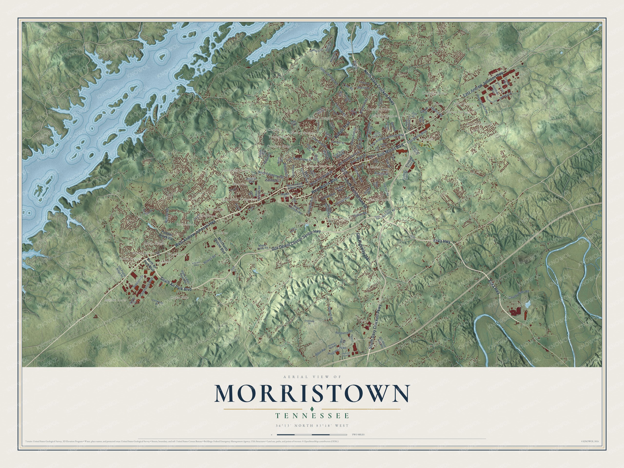
Morristown, Tennessee Map Art
Building by building, with labeled streets and shaded relief.
12" x 18" Archival Matte Print
A Map of Home. A Work of Art.
Explore Morristown, Tennessee from a whole new perspective. Created using aerial imagery and detailed geographic data, this map captures Morristown building by building, with labeled streets, familiar landmarks, and shaded topographical relief that highlights the natural contours of the landscape.
Combining modern data with the timeless character of a vintage atlas, this map is just as interesting up close as it is beautiful on the wall. Whether you grew up in Morristown, spent memorable years there, or call it home today, this unique map is a great way to celebrate a place that means something to you. Zoom in on the preview to look for your street, and then order a print to put your memories on the wall.
Three ways to hang it

Unframed archival matte, a black wood frame or a white wood frame.
Up close
Geography Worth Displaying
This map was created using accurate cartographic data and authoritative geographic sources, including the U.S. Geological Survey and the Census Bureau. The map brings together terrain, waterways, roads, and building detail. The majority of the streets are labeled, houses are accurately depicted, and the topography is derived from government sources. Combining local data with carefully composed color and shading leads to this beautifully detailed Morristown artwork for your wall.
Rather than simply showing street outlines, we’ve included as many of the street names as we could reasonably fit on the map while keeping their names legible. Zoom in on the high resolution preview to see exactly what’s on the map. We truly set out to create a statement piece for anyone who loves Morristown. So whether it’s for you, or a gift for someone you love, we hope this map of Morristown brings back fond memories.
Read the story behind this map of Morristown, Tennessee from 2026.

Find your street
Names on the Morristown map
Every name below is printed on this map. Look for your street, your school, the park where you played, or the pond down the road.
Places and landmarks34
- Morristown City Center
- Britton Acres
- Witt
- Fuller Estates
- Ridgeview
- Liberty Heights
- Cedar Hills
- Coulter
- Dalton Heights
- Casablanca
- Melody Acres
- Lakeview
Show all 34 places
- Hillcrest
- Landmark Estates
- Pineville
- The Colonies
- Greenwood Acres
- West Hills
- Wood Acres
- Brentwood
- Belair
- Havley Springs
- Crockett Ridge
- Brockland Acres
- Alpha
- Prima Estates
- Westview
- Alpha Heights
- Oakwood
- Lampkin Acres
- Campbell Acres
- Barton Springs
- Vantage View
- Echo Hills
Streets and roads135
- South Davy Crockett Parkway
- Enka Highway
- Gov Dewitt Clinton Sentor Highway
- North Davy Crockett Parkway
- South Air Park Boulevard
- South Cumberland Street
- West Morris Boulevard
- Buffalo Trail
- West Andrew Johnson Highway
- East Andrew Johnson Highway
- East Morris Boulevard
- West First North Street
- Cherokee Drive
- East Main Street
- Progress Parkway
- Howell Road
- North Economy Road
- Walters Drive
- Brights Pike
- Commerce Boulevard
- Lincoln Avenue
- Sherwood Drive
- McFarland Street
- Sublett Road
- Parker Road
- Oak Street
- Forest Drive
- Fairview Road
- Superior Drive
- Spout Springs Road
Show all 135 streets
- Chucky River Road
- Montvue Avenue
- Jaybird Road
- Murrell Road
- Doyal Drive
- Lennie Avenue
- Jarnigan Avenue
- Jeffrey Lane
- Russell Street
- Resource Drive
- Allen Road
- Collins Street
- Tyler Road
- Bell Road
- North Air Park Boulevard
- Panther Creek Road
- Merchants Greene Boulevard
- North Liberty Hill Road
- South Economy Road
- Sulphur Springs Road
- Joe Hall Road
- Maple Valley Road
- Wilshire Boulevard
- North Henry Street
- Jones Franklin Road
- West Economy Road
- Alpha Valley Home Road
- East Second North Street
- North Fairmont Avenue
- Old White Pine Road
- College Park Drive
- Davis Avenue
- Witt Road
- Pauline Avenue
- Virginia Avenue
- East Sixth North Street
- Crockett Trace Drive
- King Avenue
- Scenic Drive
- Hamblen Avenue
- Warren Drive
- Fish Hatchery Road
- Debi Circle
- Lee Street
- Dawns Trce
- South Hill Street
- Apple Blossom Lane
- Cliff Street
- Old Poplar Ridge Road
- Feltner Road
- Ironwood Drive
- Carriger Street
- Elwood Drive
- Church Street
- Shoreline Vis
- Maden Drive
- Clancy Street
- Wildlife Way
- Bales Drive
- Prater Drive
- Miller Avenue
- Desoto Avenue
- Josh Lane
- Hunter Street
- Delta Drive
- Taft Street
- Cole Road
- Thompson Creek Road
- Brookfield Drive
- Holston Drive
- Lloyd Street
- North High Street
- Howard Allen Road
- Harrell Street
- Deerfield Drive
- Starboard Crest Road
- Center Street
- McCrary Drive
- Wilder Street
- North Outer Drive
- Ryder Lane
- Power Drive
- Ash Street
- Farm Road
- Cherry Avenue
- Fox Drive
- Valley Home Road
- Interstate View Drive
- Veterans Parkway
- Shields Ferry Road
- Old Liberty Hill Road
- Berkeley Drive
- Callaway Drive
- Hugh Drive
- Catron Lane
- Industrial Avenue
- Holston Valley Road
- Manchester Avenue
- Merwin Street
- Berkline Drive
- Wendy Street
- Baylor Avenue
- Norman Street
- Foard Drive
- Helton Lane
Names are listed as they appear on the printed map. Zoom into the product photos to find them.
About Morristown, Tennessee
Morristown is a city of 30,431 people and the county seat of Hamblen County, along Cherokee Lake on the Holston River. Gideon Morris, a farmer who had fought beside John Sevier in 1776 and later at Kings Mountain, came here with his brothers Daniel and Absalom. North Carolina granted the three brothers land in 1787, and the settlement took their family name.
In 1792 and 1793 the town's main street became part of a stage road between Knoxville and Abingdon, Virginia, and more settlers followed it in. By 1833 the village had a post office, a store, a blacksmith and machine shop, and log homes along the Great Stage Road, which split it between Grainger and Jefferson counties. Morristown was incorporated in 1855, and the East Tennessee and Virginia Railroad reached it in 1858. Residents and nearby towns complained about travel and communication across the county line, so in 1870 Hamblen County was formed from parts of four counties, with Morristown as its seat.
- Davy Crockett's boyhood homeJohn Crockett settled east of the Morris home in 1794 with his son Davy, then seven years old, and built a log cabin that became a tavern. Davy lived here until 1809, when he moved to Middle Tennessee. During the Civil War the tavern served as a smallpox hospital, and it was torn down afterward to stop the disease. The Crockett Tavern Museum now stands near the spot and joined the National Register in 2013.
- Vaughn's Stampede, 1864On October 28, 1864, the Union troops of General Alvan C. Gillem struck Confederates led by General John C. Vaughn in and around town. Gillem routed them, and Vaughn fell back to Carter's Station on the Watauga River. The Battle of Morristown left about 335 casualties, and the Confederate retreat became known as Vaughn's Stampede.
- The Enka strike of 1950American Enka, a rayon maker from Asheville, began building a 230-acre plant in Lowland in 1944 and started production in 1947. In March 1950 its workers walked out, and the company advertised their jobs. Shots were fired, cars were damaged and a nearby house was dynamited, so Governor Gordon Browning sent in the National Guard. The strike made front pages across the country, and Senator Hubert Humphrey led congressional hearings on labor relations in Morristown.
- Rose School and the courthouseRose School, built in 1892, is the oldest school in Morristown. It was restored as Rose Center, a civic center, and joined the National Register in 1976. The county waited four years after choosing Morristown as its seat before a courthouse went up, and the Hamblen County Courthouse was listed in 1973.
- Building an industrial cityStarting in 1959, city leaders and state development officials set out to make Morristown an industrial hub, beginning with the East Tennessee Valley Industrial District near Russellville. The Jeffrey Manufacturing Company, the world's largest chain maker, opened a plant in Morristown in 1962. When that 375-acre park filled up in 1978, the city bought 670 acres near the airport and opened a second park there in 1981.
Keep exploring Tennessee
Morristown is one of 640 Tennessee towns we've mapped. Every dot on the map is a print of its own.
The search covers every state, Tennessee first.
Near Morristown
Order 2 or more town maps and save 10%. Shown in the size and finish you picked above, so they hang as a set.
- Marguerite 12" x 18" / Archival Matte Print $39.99
- East Ridge 12" x 18" / Archival Matte Print $39.99
- Talbott 12" x 18" / Archival Matte Print $39.99


More maps nearby: Russellville, White Pine, Bean Station, Whitesburg and Baneberry.
The art of mapping a place
How This Map Was Made
Real places. Remarkable detail. Discover the layers that turn geographic data into a map of home.

The view from above
Aerial imagery reveals the character of the land: woodland, open fields, and the patterns of a place.

The shape of the land
Elevation data brings hills, valleys, and subtle changes in the landscape into view.

The details of home
Roads, waterways, and building footprints come together to make the map feel unmistakably local.

Geography becomes art
Considered color, shading, and typography bring the layers together in a map made for your wall.


Process illustrated with Mendon, Massachusetts. Aerial imagery: USDA NAIP. Terrain: USGS 3D Elevation Program. Map details and finished artwork: KNOWOL.
The Details
About This Print
Choose an archival matte print, or a black or white Ayous wood frame. The archival matte print is unframed.
Select your size and finish above to see the matching product image and price.
Materials & Craftsmanship
A contemporary map with the character of a classic atlas, printed on archival matte paper. Optional frames are made from Ayous wood.
Your printed map does not include the watermark shown in the full-map preview.
Shipping & Delivery
Free shipping within the United States. Every print is made to order in the USA.
Buying a gift? Add a note in your cart and we'll include it. We never put prices in the package.
Prints ship within 2 to 3 business days. Allow 7 to 10 days total from ordering for delivery. Timing may vary during holidays or periods of high order volume.
Read our shipping policy.
Returns and damaged prints
Each print is made to order. Change-of-mind refunds are not available after production.
If your print arrives damaged, misprinted or incorrect, contact support@knowol.com within 30 days of receiving it. Include your order number, photos and a description of the issue.
Read our full refund and replacement policy. For questions about your order, email support@knowol.com.