


Search for another town


Free U.S. delivery 7 to 10 days after you order
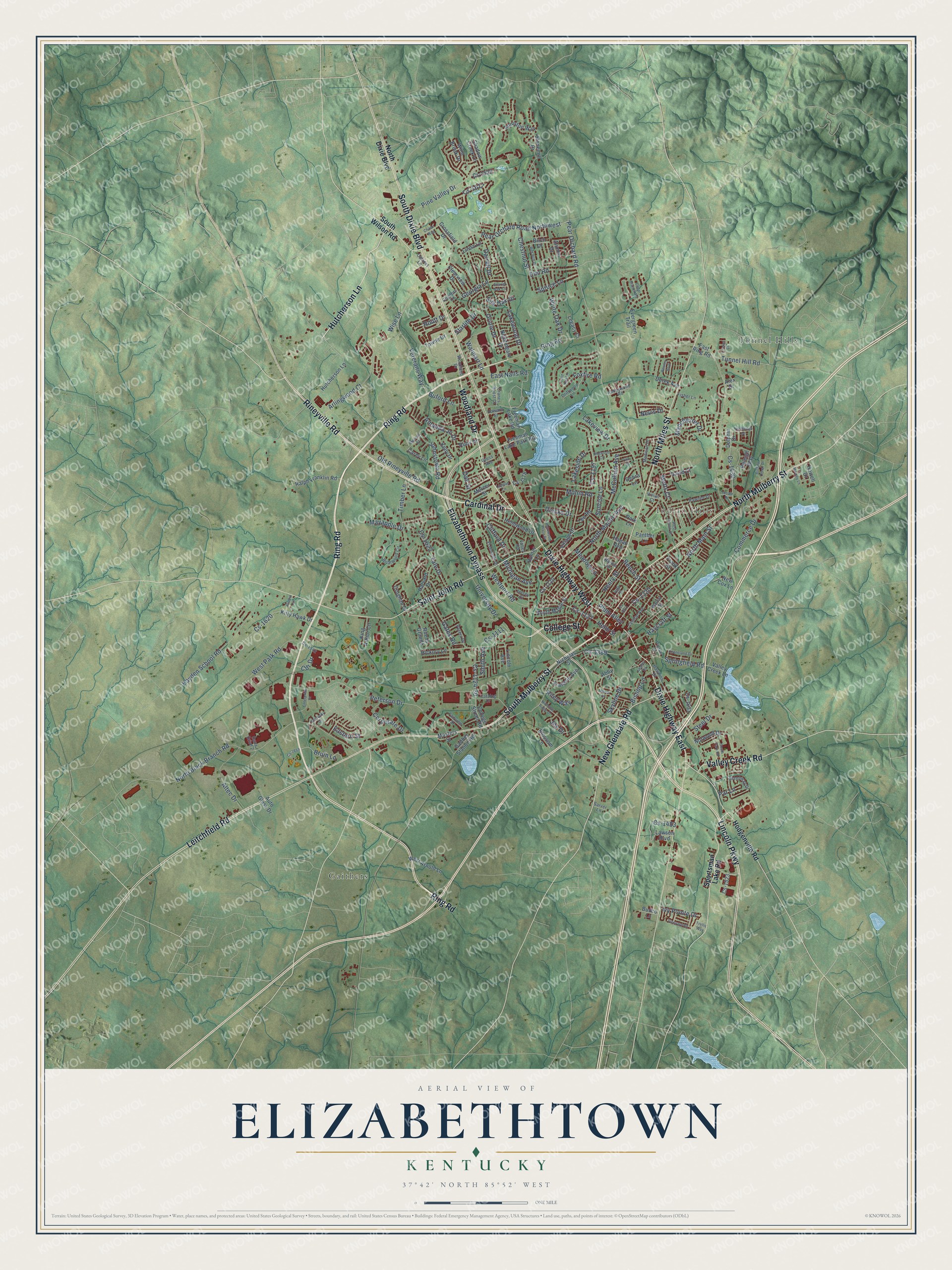
Elizabethtown, Kentucky Map Art
Building by building, with labeled streets and shaded relief.
12" x 18" Archival Matte Print
A Map of Home. A Work of Art.
Explore Elizabethtown, Kentucky from a whole new perspective. Created using aerial imagery and detailed geographic data, this map captures Elizabethtown building by building, with labeled streets, familiar landmarks, and shaded topographical relief that highlights the natural contours of the landscape.
Combining modern data with the timeless character of a vintage atlas, this map is just as interesting up close as it is beautiful on the wall. Whether you grew up in Elizabethtown, spent memorable years there, or call it home today, this unique map is a great way to celebrate a place that means something to you. Zoom in on the preview to look for your street, and then order a print to put your memories on the wall.
Three ways to hang it

Unframed archival matte, a black wood frame or a white wood frame.
Up close
Geography Worth Displaying
This map was created using accurate cartographic data and authoritative geographic sources, including the U.S. Geological Survey and the Census Bureau. The map brings together terrain, waterways, roads, and building detail. The majority of the streets are labeled, houses are accurately depicted, and the topography is derived from government sources. Combining local data with carefully composed color and shading leads to this beautifully detailed Elizabethtown artwork for your wall.
Rather than simply showing street outlines, we’ve included as many of the street names as we could reasonably fit on the map while keeping their names legible. Zoom in on the high resolution preview to see exactly what’s on the map. We truly set out to create a statement piece for anyone who loves Elizabethtown. So whether it’s for you, or a gift for someone you love, we hope this map of Elizabethtown brings back fond memories.
Read the story behind this map of Elizabethtown, Kentucky from 2026.

Find your street
Names on the Elizabethtown map
Every name below is printed on this map. Look for your street, your school, the park where you played, or the pond down the road.
Places and landmarks3
- Indian Hills
- Gaithers
- Tunnel Hills
Streets and roads223
- Ring Road
- Rineyville Road
- Woodland Drive
- Hutcherson Lane
- South Mulberry Street
- Cardinal Drive
- North Mulberry Street
- Lincoln Parkway
- College Street
- Elizabethtown Bypass
- Leitchfield Road
- Dixie Highway East
- Saint John Road
- North Miles Street
- New Glendale Road
- Valley Creek Road
- Dixie Highway West
- South Dixie Boulevard
- Pear Orchard Road Northwest
- Pine Valley Drive
- Veterans Way
- Pear Orchard Road
- Peterson Drive
- Westport Road
- Spruce Lane
- North Black Branch Road
- Cdr Drive
- Cs-1197
- West Park Road
- Cs-1389
Show all 223 streets
- Cs-1320
- North Main Street
- Cs-1124-30
- Hayden School Road
- Arlingwood Court
- Foxfire Road
- Lakewood Drive
- Commerce Drive
- Oriole Drive
- White Oak Drive
- Tunnel Hill Road
- Cs-1620
- Timber Lane
- Skyline Drive
- Amanda Jo Drive
- Gates Road
- North Mantle Avenue
- Sunrise Lane
- Diecks Drive
- Altec Drive
- Cs-1430
- Cs-1483
- Old Rineyville Road
- Cs-1617
- University Drive
- Chestnut Street
- Johnstown Road
- Cs-1127
- Helm Street
- Springfield Road
- Wise Lane
- McCullum Avenue
- Clifford Drive
- Oak Street
- Henry Street
- East Nalls Road
- Corporate Drive
- Bruin Lane
- Walmart Lane
- Beech Street
- Steel Drive
- Georgia Lane
- Meadow Lane
- Haycraft Street
- Bishop Lane
- Metts Court
- Lakeside Drive
- Manchester Drive
- Monin Road
- Ivy Pointe Drive
- Buford Lane
- Darrell Drive
- Michigan Avenue
- Plum Alley
- Yale Drive
- Lakeview Drive
- Mayapple Drive
- Smith Avenue
- Cs-1622
- Routt Drive
- Silk Oak Drive
- Eastern Street
- Starlite Drive
- Cs-1111
- Riley Way
- Nevis Drive
- Elm Road
- Par Lane
- Jey Drive
- Hodgenville Road
- Sportsman Lake Road
- South Wilson Road
- North Dixie Boulevard
- Freeman Lake Park Road
- Nightingale Drive
- Freeman Lake Road
- Nicholas Street
- College Street Road
- Kitty Hawk Drive
- Gaither Station Road
- Dolphin Drive
- Village Drive
- Lawson Boulevard
- Ralph Franklin Road
- Panther Lane
- Towne Drive
- South Maple Street
- Anniston Way
- Evergreen Trail
- Carey Lane
- Helmwood Drive
- Hickory Lane
- Derek Avenue
- Stonemill Drive
- Rue la Grande
- David Court
- Clearview Drive
- Harvard Drive
- New Cox Lane
- West Arnold Lane
- Lee Road
- Alumni Drive
- Kelly Drive
- Lincoln Avenue
- Debra Lane
- Croghan Drive
- Franklin Avenue
- Cs-1120
- Wind Brook Drive
- Norwood Drive
- King Arthur Circle
- Linda Lane
- Crossfield Drive
- Cs-1631
- Hunter Lane
- Shadow Creek Lane
- Blossom Lane
- Birch Drive
- Auto Glass Drive
- Legacy Court
- Masters Street
- Mercer Street
- Valley Creek Lane
- Hagan Avenue
- East Ring Road
- Ruby Drive
- Cs-1535
- Raleigh Way
- Howell Drive
- Park Lane
- Cs-1523
- Budco Lane
- Cs-1178
- Frank Street
- Abby Street
- Alex Drive
- Madison Drive
- Hawkins Drive
- Greenway Drive
- Pawnee Drive
- Briarwood Circle
- Central Avenue
- Driftwood Lane
- El Dorado Drive
- Hardin Street
- Cranes Roost Court
- Abbeywood Road
- Cabinet Lane
- Fairview Drive
- Catalog Drive
- Peters Drive
- Childers Court
- Fisher Lane
- Howard Street
- Cs-1542
- Pierce Street
- Walnut Street
- Dana Drive 2
- Sarver Lane
- Jersey Court
- Valley Road
- Vivian Court
- Gross Avenue
- West French Street
- Red Bud Drive
- Bewley Boulevard
- Nicholas Ridge Drive
- Cave Run Lane
- Enterprise Drive
- Helmwood Plaza Drive
- Moore Drive
- Northridge Drive
- Buffalo Creek Drive
- Kentucky Drive
- South Park Road
- Adams Road
- Keeneland Drive
- Chase Way
- Cs 1011
- Dogwood Circle
- Vineyard Road
- Medley Lane
- Melissa Street
- Cedar Branch Road
- Cricket Lane
- Cs-1659
- Layman Lane
- Scarlet Oak Circle
- Pike Street
- Josale Drive
- Durbin Lane
- Trellis Way
- High Street
Names are listed as they appear on the printed map. Zoom into the product photos to find them.
About Elizabethtown, Kentucky
Elizabethtown is a city of 31,394 people and the county seat of Hardin County. Before it had a name, the spot was known as the Severn's Valley Settlement. In 1793, the year Hardin County was formed, Colonel Andrew Hynes had 30 acres surveyed and divided into streets and lots. He named the new town for his wife, and it was legally established in 1797.
In 1850 Kentucky chartered the Louisville and Nashville Railroad to build a line from Louisville toward Nashville. John L. Helm became the railroad's president in October 1854 and steered the main line through Elizabethtown, where the first train pulled in on June 15, 1858. The tracks turned the town into a busy trade center, and they also made it a target in the Civil War.
“As early as 1806 Elizabethtown, with 22 lawyers, had a reputation as a legal center.”
- Where Lincoln's sister was bornThomas Lincoln helped Samuel Haycraft dig a millrace for his mill on Valley Creek. After Thomas married Nancy Hanks in 1806, the couple lived in a log cabin in Elizabethtown, and their daughter Sarah was born here in 1807. Soon the family left for the Sinking Spring Farm, and Abraham Lincoln was born there in 1809. After Nancy died in 1818, Thomas came back to Elizabethtown to marry Sarah Bush Johnston, who became Abraham's stepmother in Indiana.
- Morgan's raid of 1862Confederate General John Hunt Morgan and 3,000 cavalrymen attacked Elizabethtown on December 27, 1862, firing more than 100 cannonballs into the town before taking it. His real target was the railroad, so he then rode north along the line, burning trestles and wrecking track. One cannonball lodged in a building on the public square. After a fire in 1887, it was set back into the rebuilt wall near its first spot, where it remains.
- Custer's cavalry, 1871 to 1873During Reconstruction, General George Armstrong Custer was stationed here with his Seventh Cavalry and an infantry battalion. The troops were sent to break up the local Ku Klux Klan, which had been attacking freedmen and other Republicans, and to close illegal stills. The Custers made their home in a cottage behind the boarding house kept by Aunt Beck Hill. That house, now the Brown-Pusey House, joined the National Register in 1974.
Keep exploring Kentucky
Elizabethtown is one of 659 Kentucky towns we've mapped. Every dot on the map is a print of its own.
The search covers every state, Kentucky first.
Near Elizabethtown
Order 2 or more town maps and save 10%. Shown in the size and finish you picked above, so they hang as a set.
- Cecilia 12" x 18" / Archival Matte Print $39.99
- Rineyville 12" x 18" / Archival Matte Print $39.99
- Radcliff 12" x 18" / Archival Matte Print $39.99
More maps nearby: Vine Grove, Boston, Sonora, Lebanon Junction and Hodgenville.
The art of mapping a place
How This Map Was Made
Real places. Remarkable detail. Discover the layers that turn geographic data into a map of home.

The view from above
Aerial imagery reveals the character of the land: woodland, open fields, and the patterns of a place.

The shape of the land
Elevation data brings hills, valleys, and subtle changes in the landscape into view.

The details of home
Roads, waterways, and building footprints come together to make the map feel unmistakably local.

Geography becomes art
Considered color, shading, and typography bring the layers together in a map made for your wall.


Process illustrated with Mendon, Massachusetts. Aerial imagery: USDA NAIP. Terrain: USGS 3D Elevation Program. Map details and finished artwork: KNOWOL.
The Details
About This Print
Choose an archival matte print, or a black or white Ayous wood frame. The archival matte print is unframed.
Select your size and finish above to see the matching product image and price.
Materials & Craftsmanship
A contemporary map with the character of a classic atlas, printed on archival matte paper. Optional frames are made from Ayous wood.
Your printed map does not include the watermark shown in the full-map preview.
Shipping & Delivery
Free shipping within the United States. Every print is made to order in the USA.
Buying a gift? Add a note in your cart and we'll include it. We never put prices in the package.
Prints ship within 2 to 3 business days. Allow 7 to 10 days total from ordering for delivery. Timing may vary during holidays or periods of high order volume.
Read our shipping policy.
Returns and damaged prints
Each print is made to order. Change-of-mind refunds are not available after production.
If your print arrives damaged, misprinted or incorrect, contact support@knowol.com within 30 days of receiving it. Include your order number, photos and a description of the issue.
Read our full refund and replacement policy. For questions about your order, email support@knowol.com.