


Search for another town


Free U.S. delivery 7 to 10 days after you order
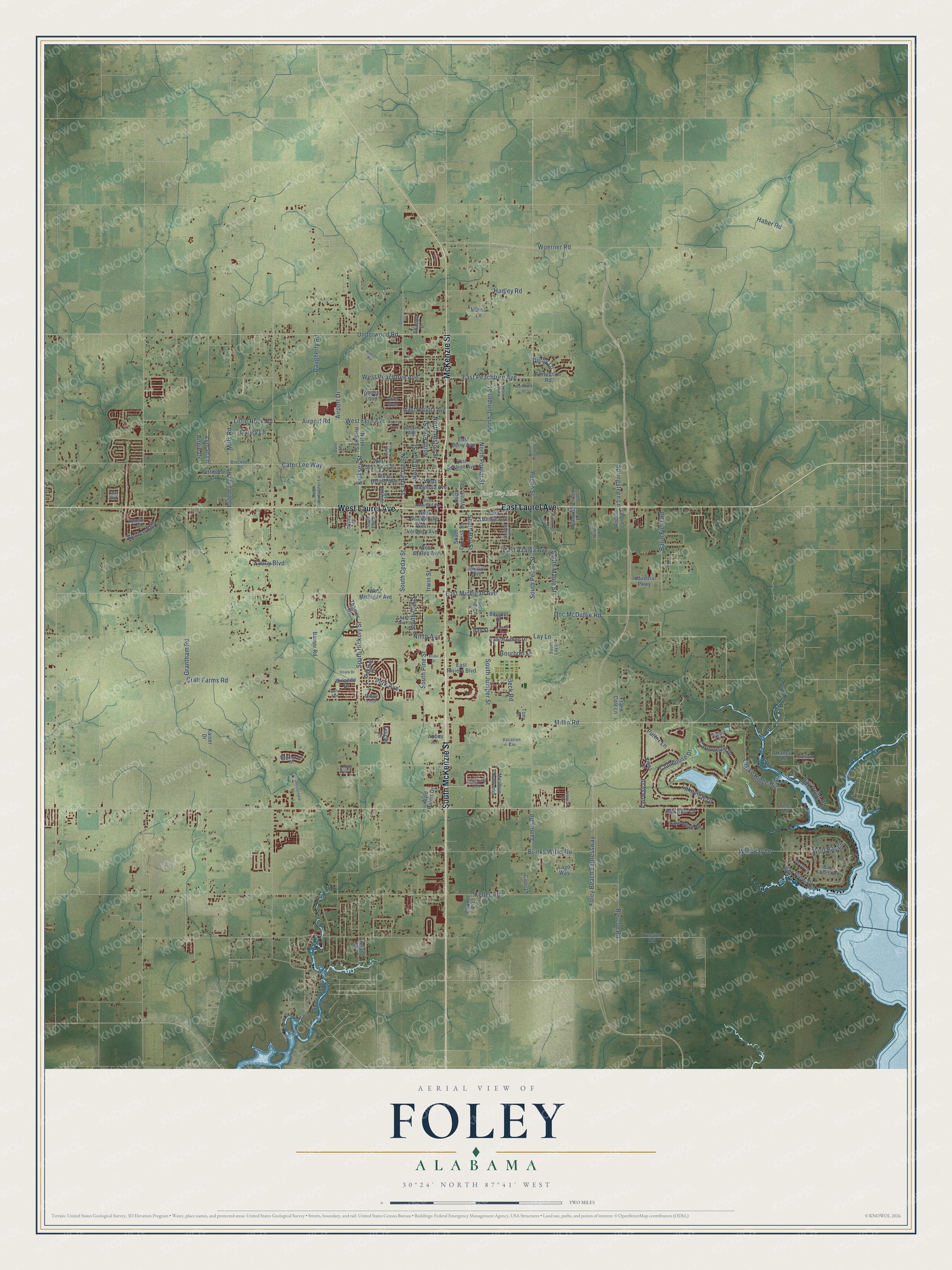
Foley, Alabama Map Art
Building by building, with labeled streets and shaded relief.
12" x 18" Archival Matte Print
A Map of Home. A Work of Art.
Explore Foley, Alabama from a whole new perspective. Created using aerial imagery and detailed geographic data, this map captures Foley building by building, with labeled streets, familiar landmarks, and shaded topographical relief that highlights the natural contours of the landscape.
Combining modern data with the timeless character of a vintage atlas, this map is just as interesting up close as it is beautiful on the wall. Whether you grew up in Foley, spent memorable years there, or call it home today, this unique map is a great way to celebrate a place that means something to you. Zoom in on the preview to look for your street, and then order a print to put your memories on the wall.
Three ways to hang it

Unframed archival matte, a black wood frame or a white wood frame.
Up close
Geography Worth Displaying
This map was created using accurate cartographic data and authoritative geographic sources, including the U.S. Geological Survey and the Census Bureau. The map brings together terrain, waterways, roads, and building detail. The majority of the streets are labeled, houses are accurately depicted, and the topography is derived from government sources. Combining local data with carefully composed color and shading leads to this beautifully detailed Foley artwork for your wall.
Rather than simply showing street outlines, we’ve included as many of the street names as we could reasonably fit on the map while keeping their names legible. Zoom in on the high resolution preview to see exactly what’s on the map. We truly set out to create a statement piece for anyone who loves Foley. So whether it’s for you, or a gift for someone you love, we hope this map of Foley brings back fond memories.

Find your street
Names on the Foley map
Every name below is printed on this map. Look for your street, your school, the park where you played, or the pond down the road.
Places and landmarks1
- Foley City Hall
Streets and roads157
- McKenzie Street
- South McKenzie Street
- East Laurel Avenue
- West Laurel Avenue
- Foley Beach Expressway
- East Michigan Avenue
- East Peachtree Avenue
- Doc McDuffie Road
- Little Rock Road
- Mills Road
- South Cedar Street
- Underwood Road
- Kicksey Street
- Airport Road
- North Cedar Street
- Cater Lee Way
- South Bay Street
- Lay Lane
- Woerner Road
- South Hickory Street
- Miflin Road
- South Juniper Street
- North Juniper Street
- North Alston Street
- Wolf Bay Drive
- Roscoe Road
- North Pine Street
- West Fern Avenue
- Bay View Drive
- James Road
Show all 157 streets
- Lakeview Drive
- Clubhouse Drive
- South Pecan Street
- South Pine Street
- Keller Road
- Clarke Ridge Road
- East Azalea Avenue
- Beck Road
- Brinks Willis Road
- Fairway Drive
- Barin Field Road
- West Peachtree Avenue
- South Oak Street
- North Oak Street
- Venice Boulevard
- Bay Point Drive
- Carnoustie Drive
- Haber Road
- North Poplar Street
- Park Avenue
- Springsteen Lane
- Durby Lane
- Hadley Road
- Respite Lane
- Irwin Street
- Craft Farms Road
- Wolf Bay Lane
- Grantham Road
- Airport Drive
- Bourbon Street
- Pecan Street
- Dailey Lane
- Ninth Avenue
- South Maple Street
- Daugherty Road
- Putter Lane
- Fancy Boulevard
- Lyman Lane
- Angie Drive
- West Michigan Avenue
- North Hickory Street
- North Cypress Street
- West Azalea Avenue
- Carmel Circle
- Meadow Run Loop
- West Magnolia Avenue
- West Section Avenue
- East Orange Avenue
- Orlando Drive
- Abbey Loop
- West Verbena Avenue
- East Section Avenue
- Parish Lakes Drive
- Wyld Palms Drive
- West Rosetta Avenue
- East Berry Avenue
- Bodenhamer Road
- East Riviera Boulevard
- Lake South Drive
- South Cypress Street
- West Orange Avenue
- Thames Drive
- West Orchid Avenue
- Bay Street
- Pettibone Lane
- Industrial Parkway
- Bay Forest Drive
- Perfection Road
- Frank Cole Lane
- Felicity Lane
- Oakford Drive
- Barner Road
- Villas Drive
- Russian Road
- Hance Lane
- Morris Lane
- Capri Lane
- Robert Lane Drive
- Beignet Drive
- Helton Drive
- Osborne Drive
- Ariel Avenue
- Kaiser Drive
- Abbey Lane
- Abacus Drive
- Lago Way
- Toler Lane
- Tony Drive
- Breckner Road
- Dale Lane
- Bellingrath Drive
- Satsuma Avenue
- Ralph Schumacher Lane
- Vacation Circle
- Heron Drive
- Sixth Avenue
- Othello Lane
- Fulton Loop
- Hamilton Boulevard
- South Elm Street
- South Lay Lane
- Wyatt Court
- Collinwood Loop
- Pride Drive
- North Pecan Street
- Surrey Loop
- Greentree Lane
- South Poplar Street
- Arcadia Drive
- North Beech Street
- Crown Walk Drive
- Dundee Circle
- South Stuart Street
- Ocala Drive
- Bender Road
- West Jessamine Avenue
- Destin Avenue
- Hudson Road
- Chesterfield Lane
- Burton Wood Drive
- Emerille Drive
- North Holly Boulevard
- Parke Boulevard
- Montesino Lane
- John Mixon Lane
- Woodland Drive
- Shoots Lane
Names are listed as they appear on the printed map. Zoom into the product photos to find them.
About Foley, Alabama
Foley is a city of 20,335 people in Baldwin County, in southwest Alabama. It carries the name of John B. Foley of Chicago, who heard about this corner of South Baldwin County from a railroad agent he met on the way to President William McKinley's funeral in 1901. Foley came down to see it for himself the next year, liked the land, and bought between 40,000 and 50,000 acres before going home to form the Magnolia Springs Land Company.
Selling that land meant getting buyers here, so Foley promised to pay for the crossties if the Louisville & Nashville Railroad would run a spur south from Bay Minette. The railroad agreed, and the first station went up in 1905, the year the town got its post office. Farmers shipped potatoes and other crops from the depot and warehouse, and Foley incorporated in 1915 with G. I. Weatherly as its first mayor.
- The Pine Knot SpecialFoley's first train burned wood and went by the name Pine Knot Special. It left in the morning and returned in the afternoon, and settlers clearing their land left lighter knots in a wood box so the engineer could feed the fire. The first station, built in 1905, burned in 1908. The station that replaced it a year later now holds the city's museum, archives and a model train exhibit.
- Land for churches and a schoolJohn Foley gave land for a school, the railroad station, a park and several churches, among them Saint Margaret of Scotland Catholic Church and the Baptist and Methodist churches. He also backed a bank, a hotel, the utility company and a demonstration farm to help the new town grow.
- Ski-Hi and The OnlookerOne of Foley's early businesses was a bottling company that made a soft drink called Ski-Hi. The town's first newspaper, a weekly called The Onlooker, started printing in 1907.
- The Miss Foley sails outEach November since 2001, Foley has held the three-day Heritage Harbor Days in Heritage Park. The Miss Foley, a 28-foot shrimp boat owned by the city, travels to another town carrying food, crafts and music from Foley, and the partner city answers with a taste of its own heritage. Towns that have traded with Foley include Winchester, Tennessee; Ozark, Missouri; and Maggie Valley, North Carolina.
Keep exploring Alabama
Foley is one of 675 Alabama towns we've mapped. Every dot on the map is a print of its own.
The search covers every state, Alabama first.
Near Foley
Order 2 or more town maps and save 10%. Shown in the size and finish you picked above, so they hang as a set.
- Elberta 12" x 18" / Archival Matte Print $39.99
- Summerdale 12" x 18" / Archival Matte Print $39.99
- Bon Secour 12" x 18" / Archival Matte Print $39.99


More maps nearby: Magnolia Springs, Orange Beach, Gulf Shores, Perdido Beach and Robertsdale.
The art of mapping a place
How This Map Was Made
Real places. Remarkable detail. Discover the layers that turn geographic data into a map of home.

The view from above
Aerial imagery reveals the character of the land: woodland, open fields, and the patterns of a place.

The shape of the land
Elevation data brings hills, valleys, and subtle changes in the landscape into view.

The details of home
Roads, waterways, and building footprints come together to make the map feel unmistakably local.

Geography becomes art
Considered color, shading, and typography bring the layers together in a map made for your wall.


Process illustrated with Mendon, Massachusetts. Aerial imagery: USDA NAIP. Terrain: USGS 3D Elevation Program. Map details and finished artwork: KNOWOL.
The Details
About This Print
Choose an archival matte print, or a black or white Ayous wood frame. The archival matte print is unframed.
Select your size and finish above to see the matching product image and price.
Materials & Craftsmanship
A contemporary map with the character of a classic atlas, printed on archival matte paper. Optional frames are made from Ayous wood.
Your printed map does not include the watermark shown in the full-map preview.
Shipping & Delivery
Free shipping within the United States. Every print is made to order in the USA.
Buying a gift? Add a note in your cart and we'll include it. We never put prices in the package.
Prints ship within 2 to 3 business days. Allow 7 to 10 days total from ordering for delivery. Timing may vary during holidays or periods of high order volume.
Read our shipping policy.
Returns and damaged prints
Each print is made to order. Change-of-mind refunds are not available after production.
If your print arrives damaged, misprinted or incorrect, contact support@knowol.com within 30 days of receiving it. Include your order number, photos and a description of the issue.
Read our full refund and replacement policy. For questions about your order, email support@knowol.com.