
Search for another town


Free U.S. delivery 7 to 10 days after you order
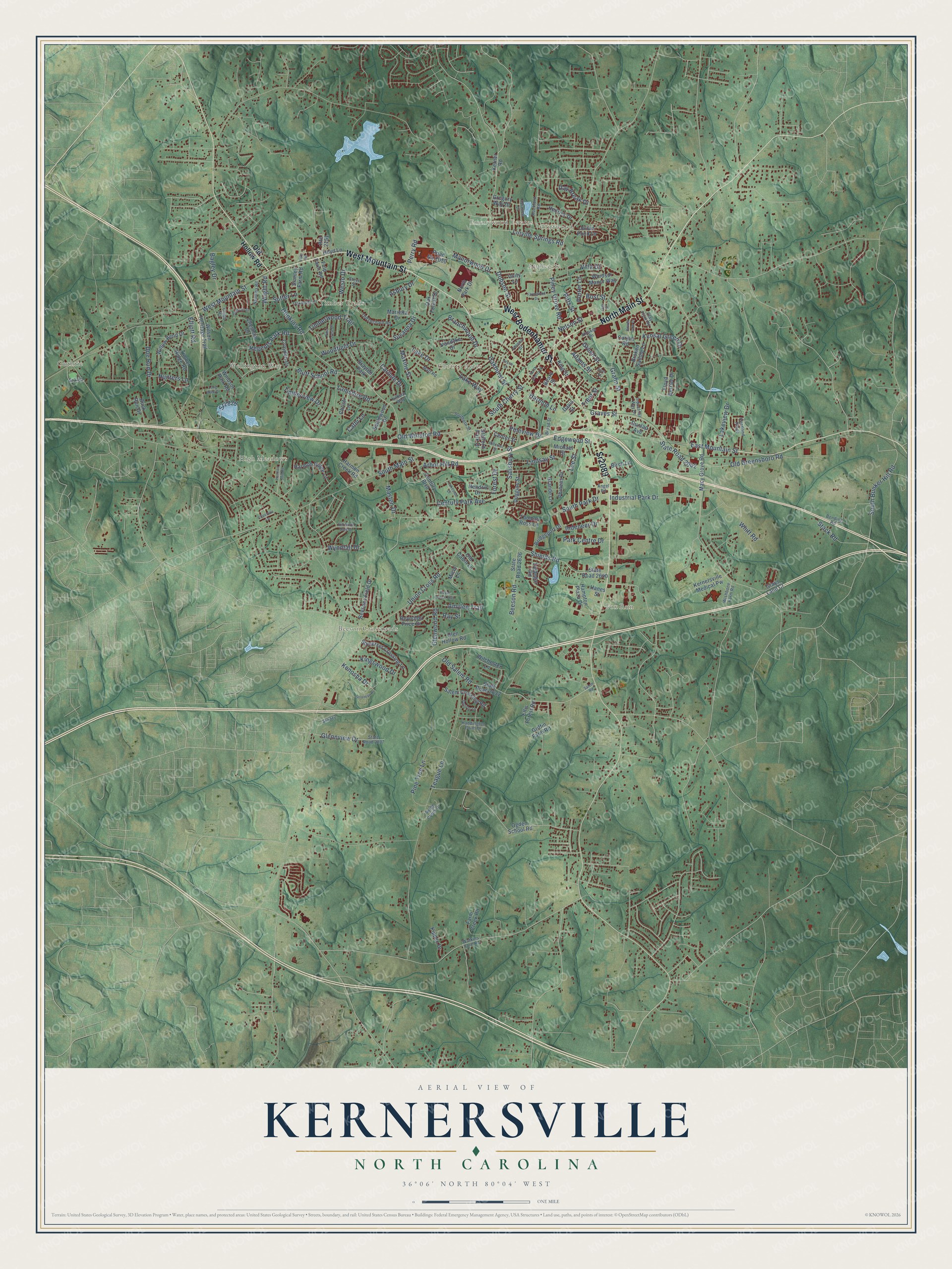
Kernersville, North Carolina Map Art
Building by building, with labeled streets and shaded relief.
12" x 18" Archival Matte Print
A Map of Home. A Work of Art.
Explore Kernersville, North Carolina from a whole new perspective. Created using aerial imagery and detailed geographic data, this map captures Kernersville building by building, with labeled streets, familiar landmarks, and shaded topographical relief that highlights the natural contours of the landscape.
Combining modern data with the timeless character of a vintage atlas, this map is just as interesting up close as it is beautiful on the wall. Whether you grew up in Kernersville, spent memorable years there, or call it home today, this unique map is a great way to celebrate a place that means something to you. Zoom in on the preview to look for your street, and then order a print to put your memories on the wall.
Three ways to hang it

Unframed archival matte, a black wood frame or a white wood frame.
Up close
Geography Worth Displaying
This map was created using accurate cartographic data and authoritative geographic sources, including the U.S. Geological Survey and the Census Bureau. The map brings together terrain, waterways, roads, and building detail. The majority of the streets are labeled, houses are accurately depicted, and the topography is derived from government sources. Combining local data with carefully composed color and shading leads to this beautifully detailed Kernersville artwork for your wall.
Rather than simply showing street outlines, we’ve included as many of the street names as we could reasonably fit on the map while keeping their names legible. Zoom in on the high resolution preview to see exactly what’s on the map. We truly set out to create a statement piece for anyone who loves Kernersville. So whether it’s for you, or a gift for someone you love, we hope this map of Kernersville brings back fond memories.
Read the story behind this map of Kernersville, North Carolina from 2026.

Find your street
Names on the Kernersville map
Every name below is printed on this map. Look for your street, your school, the park where you played, or the pond down the road.
Places and landmarks11
- Christy Acres
- Beeson Crossroads
- Guthrie
- Cliffwood
- Fox Run
- Wellington Way
- High Meadows
- Applegate
- Timber Trails
- Emorywood Estates
- Drayton Park
Streets and roads193
- West Mountain Street
- Sr2089
- North Main Street
- West Bodenhamer Street
- Union Cross Road
- Hopkins Road
- East Mountain Street
- South Main Street
- Bluff School Road
- Old Salem Road
- Old Greensboro Road
- Piney Grove Road
- Shields Road
- Teague Lane
- Branchwood Drive
- Regents Park Road
- Gralin Street
- South Cherry Street
- Pineview Drive
- Salisbury Street
- Doe Run Drive
- Lake Drive
- Pine Tree Lane
- Old Winston Road
- Dobson Street
- Century Park Avenue
- Graves Street
- Nelson Street
- Glenwood Road
- Whitt Road
Show all 193 streets
- Industrial Park Drive
- Timberwood Trail
- Manorwood Drive
- Woodfield Drive
- Glennview Drive
- Linville Springs Road
- Beeson Road
- Kensal Green Drive
- South Bunker Hill Road
- Bagley Drive
- State Road 2042
- Harmon Lane
- Indeneer Drive
- Lindsay Street
- Oakhurst Street
- Adams Street
- Weslo Drive
- Forest Drive
- South Park Drive
- Bost Street
- Green Street
- Timberview Drive
- Kingswood Drive
- Masten Drive
- Perry Road
- Arbor Hill Road
- Lamshire Road
- Park Centre Drive
- Lakeview Drive
- Susanna Drive
- Edgewood Street
- Wyndfall Drive
- Kenosha Drive
- Wright Road
- Amylee Trail
- Stack Road
- Carlisle Drive
- Hunters Lane
- Day Break Drive
- Pitts Street
- Lake Way
- Maxine Street
- Lee Street
- Villa Drive
- Sr2828
- Asbury Drive
- Sutter Lane
- Cathi Lane
- Porter Lane
- Elliott Road
- Ray Street
- Trent Street
- Old Hollow Road
- Macy Grove Road
- State Road 2640
- Road No 2050
- State Road 2632
- State Road 2636
- Chesham Drive
- Willow Bend Drive
- Somerset Crossing Lane
- Ellis Forest Road
- Glen Hollow Road
- Wilson Heritage Trail
- Beesons Field Drive
- Kernersville Medical Pw
- Century Boulevard
- Tredegar Road
- Ogden School Road
- Timber Ridge Road
- Salem Crossing Road
- Reynolds Price Drive
- Harmon Ridge Lane
- Hedrick Drive
- Bridgeport Drive
- Fulp Farm Road
- Duggins Street
- Stanley Farm Road
- Marietta Drive
- Julian Pond Lane
- Phineas Drive
- Hampton Plaza Drive
- Croyden Drive
- Harmon Creek Road
- Broken Saddle Lane
- Thomas Ross Lane
- Vandyke Drive
- Farm Creek Road
- Kippen Drive
- Oak Forest Drive
- Windsor Manor Way
- Wilchester Lane
- Sattlewood Drive
- Christi Lane
- Buck Run Drive
- Gregory Way Drive
- Birch Lane
- Floyd Berrier Drive
- Griffin Farm Road
- Hendrix Drive
- Stafford Park Drive
- Windsor Park Road
- Grande Lane
- Michael Street
- King Street
- Center Street
- North Park Drive
- Corjon Road
- Grays Land Court
- Old Cabin Lane
- Dunlap Avenue
- Micol Lane
- Hoyd Lane
- Unity Lane
- Hanes Street
- Kerner Road
- Route 2151
- Beard Street
- Davis Street
- State Road 2837
- Bending Road
- Clay Flynt Road
- Rockford Road
- Old Orchard Road
- Broad Street
- Oakmont Court
- Haddington Point Drive
- Kentland Ridge
- Southern Street
- Sr2781
- Matt Road
- Sr4312
- Nandina Road
- Industrial Way Drive
- Clubb Road
- Ridge Creek Drive
- Hooker Lane
- Wishbone Farm Road
- Angel Road
- Kilburn Way
- Steve Street
- Vernon Street
- Watkins Ford Road
- North Cherry Street
- Aquaview Drive
- Hill North Dale Drive
- Squires Lane
- Farmwood Drive
- Pine Forest Drive
- Hillcrest Street
- Long Walk Drive
- Lakeside Drive
- Oak Street
- Harmon Mill Road
- Royal Coach Trail
- Daffodil Drive
- Soloman Drive
- Bowen Lake Drive
- Joyce Lane
- Clipstone Lane
- Salem Road
- Fulp Road
- Sam Street
Names are listed as they appear on the printed map. Zoom into the product photos to find them.
About Kernersville, North Carolina
Kernersville is a town of 26,449 people in Forsyth County, between Winston-Salem and Greensboro. An Irishman named Caleb Story settled the site in 1756, and around 1770 William Dobson bought the land. The place came to be called Dobson's Crossroads, and George Washington stopped at Dobson's tavern for breakfast on June 2, 1791.
Joseph Kerner, born Joseph Kirner in Furtwangen, Germany, bought the property in 1817 and kept the inn open. People began calling the spot Kerners Crossroads, and the name stuck as the settlement grew. After the railroad arrived, the town was incorporated as Kernersville. A 1949 county history puts that in 1869 and says voters chose Joseph Armstrong as the first mayor.
- Korner's Folly, finished in 1880This house holds 22 rooms spread over seven levels, with 15 decorated fireplaces. In 1896 it gained the first private theatre in the United States. It joined the National Register in 1973, and in 2001 a model of the house hung on the White House Christmas tree as North Carolina's ornament.
- Two World Series titlesKemp Wicker of Kernersville pitched for the New York Yankees and won the World Series with them in 1936 and 1937.
Keep exploring North Carolina
Kernersville is one of 952 North Carolina towns we've mapped. Every dot on the map is a print of its own.
The search covers every state, North Carolina first.
Near Kernersville
Order 2 or more town maps and save 10%. Shown in the size and finish you picked above, so they hang as a set.
- Colfax 12" x 18" / Archival Matte Print $39.99
- Walkertown 12" x 18" / Archival Matte Print $39.99
- Oak Ridge 12" x 18" / Archival Matte Print $39.99


More maps nearby: Wallburg, High Point, Winston-Salem, Stokesdale and Jamestown.
The art of mapping a place
How This Map Was Made
Real places. Remarkable detail. Discover the layers that turn geographic data into a map of home.

The view from above
Aerial imagery reveals the character of the land: woodland, open fields, and the patterns of a place.

The shape of the land
Elevation data brings hills, valleys, and subtle changes in the landscape into view.

The details of home
Roads, waterways, and building footprints come together to make the map feel unmistakably local.

Geography becomes art
Considered color, shading, and typography bring the layers together in a map made for your wall.


Process illustrated with Mendon, Massachusetts. Aerial imagery: USDA NAIP. Terrain: USGS 3D Elevation Program. Map details and finished artwork: KNOWOL.
The Details
About This Print
Choose an archival matte print, or a black or white Ayous wood frame. The archival matte print is unframed.
Select your size and finish above to see the matching product image and price.
Materials & Craftsmanship
A contemporary map with the character of a classic atlas, printed on archival matte paper. Optional frames are made from Ayous wood.
Your printed map does not include the watermark shown in the full-map preview.
Shipping & Delivery
Free shipping within the United States. Every print is made to order in the USA.
Buying a gift? Add a note in your cart and we'll include it. We never put prices in the package.
Prints ship within 2 to 3 business days. Allow 7 to 10 days total from ordering for delivery. Timing may vary during holidays or periods of high order volume.
Read our shipping policy.
Returns and damaged prints
Each print is made to order. Change-of-mind refunds are not available after production.
If your print arrives damaged, misprinted or incorrect, contact support@knowol.com within 30 days of receiving it. Include your order number, photos and a description of the issue.
Read our full refund and replacement policy. For questions about your order, email support@knowol.com.