
Search for another town


Free U.S. delivery 7 to 10 days after you order
Winston-Salem, North Carolina Map Art
Building by building, with labeled streets and shaded relief.
12" x 18" Archival Matte Print
A Map of Home. A Work of Art.
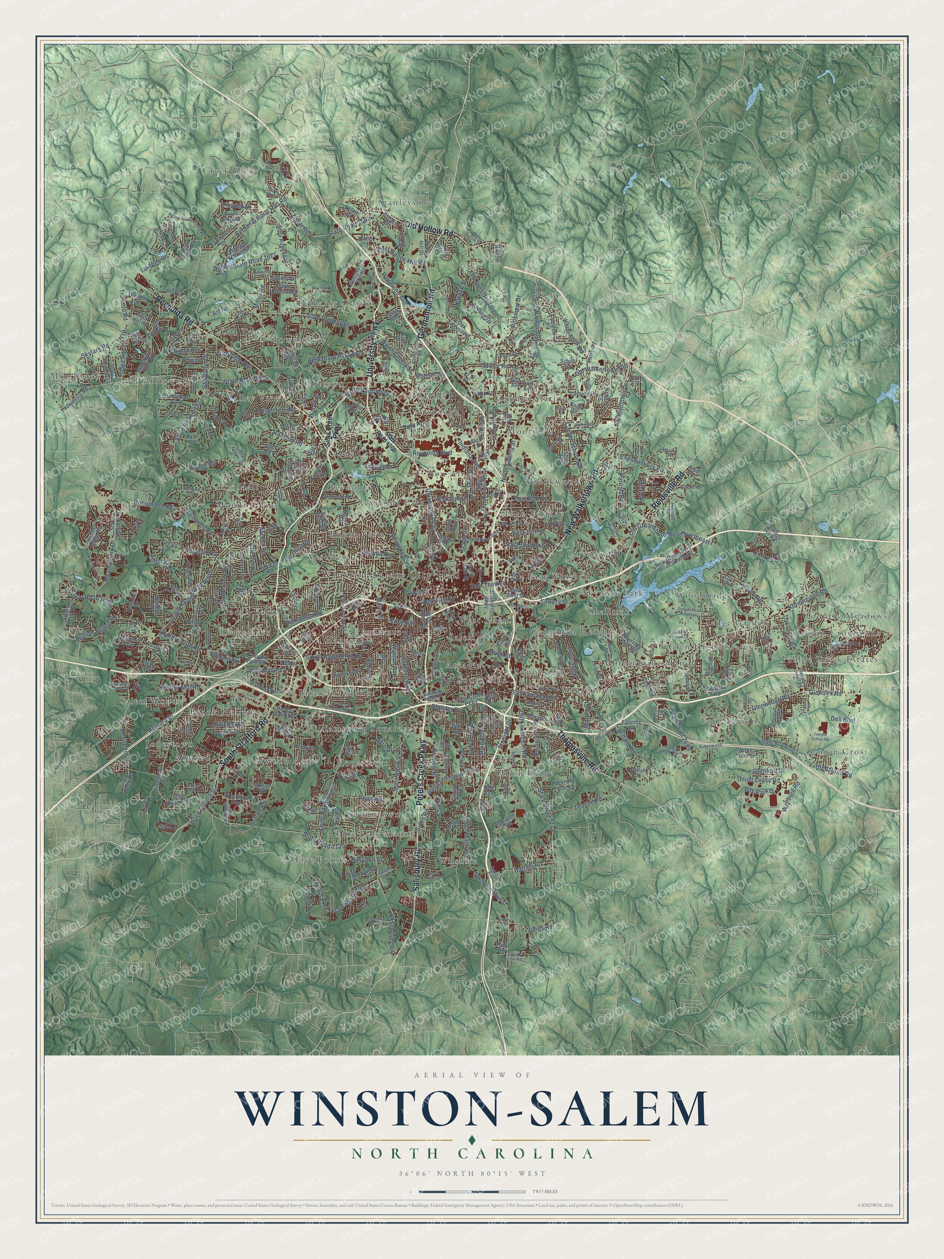
Explore Winston-Salem, North Carolina from a whole new perspective. Created using aerial imagery and detailed geographic data, this map captures Winston-Salem building by building, with labeled streets, familiar landmarks, and shaded topographical relief that highlights the natural contours of the landscape.
Combining modern data with the timeless character of a vintage atlas, this map is just as interesting up close as it is beautiful on the wall. Whether you grew up in Winston-Salem, spent memorable years there, or call it home today, this unique map is a great way to celebrate a place that means something to you. Zoom in on the preview to look for your street, and then order a print to put your memories on the wall.
Three ways to hang it

Unframed archival matte, a black wood frame or a white wood frame.
Up close
Geography Worth Displaying
This map was created using accurate cartographic data and authoritative geographic sources, including the U.S. Geological Survey and the Census Bureau. The map brings together terrain, waterways, roads, and building detail. The majority of the streets are labeled, houses are accurately depicted, and the topography is derived from government sources. Combining local data with carefully composed color and shading leads to this beautifully detailed Winston-Salem artwork for your wall.
Rather than simply showing street outlines, we’ve included as many of the street names as we could reasonably fit on the map while keeping their names legible. Zoom in on the high resolution preview to see exactly what’s on the map. We truly set out to create a statement piece for anyone who loves Winston-Salem. So whether it’s for you, or a gift for someone you love, we hope this map of Winston-Salem brings back fond memories.
Read the story behind this map of Winston-Salem, North Carolina from 2026.

Find your street
Names on the Winston-Salem map
Every name below is printed on this map. Look for your street, your school, the park where you played, or the pond down the road.
Places and landmarks63
- Winston-Salem City Hall
- Jonestown
- Stanleyville
- Beeson Crossroads
- Mill Brook
- South Fork
- Tower Gate
- Union Cross
- Pine Dale Manor
- Ogburn Station
- Union Ridge
- Woodbridge
Show all 63 places
- Bon Air
- Mount Tabor
- Ardmore
- Five Points
- Reynolda
- Shalimar
- Williamsburg Square
- Waughtown
- Pebble Creek Estates
- Four Seasons
- Valley View
- Creek View
- Park Terrace
- Hootstown
- South Side
- Oak Crest
- Brook Hollow
- Montview
- East Winston
- Bethania Station
- Sedge Garden
- Atwood Acres
- Westview
- Swaimtown
- Country Meadows
- Buena Vista
- Hanes
- Sunnyside
- Old Town
- Salem
- Alspaugh
- Oldtown
- Atwood
- Pfafftown
- Briarcliff Manor
- Glen High Estates
- Cityview
- Morningside Manor
- Wilshire
- Columbia Heights
- Salem Woods
- Brookwood
- Reynolda Park
- Arcadia
- Fox Hall
- Forest Hills
- West Salem
- Skyview Park
- Burke Park
- Frontis
- Tinley Park
Streets and roads411
- University Parkway
- Peters Creek Parkway
- South Stratford Road
- Reynolda Road
- New Walkertown Road
- Old Hollow Road
- Reidsville Road
- Germanton Road
- Thomasville Road
- Salisbury Road
- South Main Street
- Shattalon Drive
- Country Club Road
- Patterson Avenue
- Indiana Avenue
- State Road 3011
- Robinhood Road
- Union Cross Road
- State Road 1525
- State Road 1120
- North Liberty Street
- Old Lexington Road
- Polo Road
- High Point Road
- Peace Haven Road North
- East Sprague Street
- State Road 1393
- Old Rural Hall Road
- Kernersville Road
- State Road 2743
Show all 411 streets
- State Road 1686
- Main Street South
- North Cherry Street
- Ebert Road
- Motor Road
- Glenn Hi Road
- Glenn High Road
- South Hawthorne Road
- Griffith Road
- Lowery Street
- Old Greensboro Road Northeast
- Old Walkertown Road
- Bethania Rural Hall Road
- Carver School Road
- Meadowlark Drive
- Darwick Road
- State Road 2967
- Northampton Drive
- State Road 3210
- Transou Road
- Cole Road
- Miller Street
- State Road 1669
- Ziglar Road
- State Road 2699
- Willard Road
- Ogburn Avenue
- Baux Mountain Road
- Bethabara Park Boulevard
- Teague Road
- Petree Road
- Swaim Road
- West First Street
- East 14th Street
- McGregor Road
- East 25th Street
- Kester Mill Road
- Ivy Avenue
- North Point Boulevard
- Lockland Avenue
- Knollwood Street
- Brewer Road
- Pleasant Street
- Queen Street
- Barnes Road
- Hope Church Road
- Yarbrough Avenue
- Reynolds Boulevard
- State Road 1677
- White Rock Road
- East Third Street
- Allistair Road
- Skylark Road
- Bus Park Drive
- Ransom Road
- Phillips Bridge Road
- Marble Street
- Millhaven Road
- Chester Road
- Linville Road
- Trade Street
- Beeson Dairy Road
- Cedar Trail
- Pope Road
- Konnoak Drive
- Hutton Street
- Ebert Street
- Cloister Drive
- Starlight Drive
- State Road 1001
- Vest Mill Road
- Briarcliffe Road
- Sides Road
- Faculty Drive
- Pineview Drive
- East Twelfth Street
- Yorkshire Road
- Atwood Road
- Parrish Road
- East Hanes Mill Road
- Romara Drive
- Paragon Drive
- Art Road
- Gyro Drive
- Jones Road
- Watson Avenue
- Archer Road
- Virginia Road
- Gilmer Avenue
- Kinnamon Road
- Denise Lane
- Avera Avenue
- Racine Drive
- Long Road
- Wallburg Road
- Woods Road
- Glenford Drive
- Novack Street
- Carlton Drive
- Retnuh Drive
- Finwick Drive
- Miller Road
- Dell Boulevard
- Sallies Lane
- Rosie Street
- Glade Street
- Leo Street
- Moat Drive
- Mock Street
- Silas Creek Parkway
- West Clemmonsville Road
- State Road 1122
- Southwest Main Street
- Jonestown Road
- Yadkinville Road
- Old Salisbury Road
- Hanes Mall Boulevard
- Research Parkway
- Oak Summit Road
- Reynolds Park Road
- Glenn Avenue North
- State Road 1676
- Old Vineyard Road
- Burke Mill Road
- State Road 1314
- Overdale Road
- State Road 1681
- Oak Grove Road
- Buena Vista Road
- West Fourth Street
- Robbins Road
- West Hanes Mill Road
- Grandview Club Road
- State Road 1003
- Turfwood Drive
- New Greensboro Road Southeast
- Lansing Drive
- Walker Road
- Park Boulevard
- Vineyard Park Road
- Thurmond Street
- Lomond Street
- Tise Avenue
- West 25th Street
- Akron Drive
- Wayside Drive
- School Street
- East First Street
- Lakeview Drive
- North Main Street
- Leight Street
- Cherokee Lane
- Fanning Road
- Wedge Drive
- Staffordshire Road
- Kapp Street
- Kirklees Road
- Hastings Hill Road
- Paula Drive
- High Cliffs Road
- Rock Hill Road
- Eastwin Drive
- Patria Street
- Clinard Avenue
- Gales Avenue
- Heron Ridge Road
- Styers Ferry Road
- Loch Drive
- Rosebriar Lane
- State Road 3978
- Westpoint Boulevard
- Poindexter Avenue
- Timlic Avenue
- Alpine Road
- Morning Star Lane
- Healy Drive
- Yale Avenue
- Plymouth Avenue
- Laura Avenue
- Balsom Road
- Twin Oak Drive
- Tiffany Avenue
- State Road 3255
- Snead Road
- Windy Hill Drive
- Link Road
- Wesmar Drive
- Janita Drive
- Sink Street
- Ada Avenue
- Stanaford Road
- Linbrook Drive
- Ormond Drive
- Nylon Drive
- Voss Street
- Davis Road
- Herndon Drive
- Wake Drive
- Linda Circle
- Anita Drive
- Winter Hue Street
- Silas Creek Road
- Kyle Road
- Emory Drive
- Mallard Lakes Drive
- Gyddie Drive
- Beth Avenue
- Davie Avenue
- Moravia Street
- Lynn Dee Drive
- Danby Drive
- Elm Drive
- Ve Trail
- Don Avenue
- Dave Street
- Lukon Lane
- Hines Drive
- River Dale Road
- Shaw Road
- Kearns Avenue
- Endsley Street
- File Street
- Swing Drive
- Velinda Drive
- Natalie Drive
- Jasper Lane
- Kimball Lane
- Dallas Drive
- Free Street
- Fleet Street
- Page Street
- Olive Street
- Rink Road
- Utah Drive
- Clark Avenue
- Tyler Drive
- Elgin Street
- Rich Avenue
- Earl Street
- Lily Drive
- State Road 4000
- State Road 1946
- East Fifth Street
- Leinbach Drive
- Ebert Road Southwest
- Bethania Road
- Junia Avenue
- Pecan Ridge Circle
- East 17th Street
- Westbrook Plaza Drive
- Butler Street
- Talcott Avenue
- Ardsley Street
- Salisbury Ridge Road
- East 27th Street
- York Road
- Red Copper Circle
- Friar Tuck Road
- Northwest Boulevard
- Monticello Drive
- Carter Circle
- Palmer Lane
- Sunnydell Drive
- Airport Road
- Centre Park Boulevard
- Hayes Forest Drive
- Creekview Drive
- Huff Circle
- Heatherton Way
- Angel Oaks Drive
- Tallison Drive
- West 13th Street
- Renon Road
- Pacific Drive
- Lexwin Avenue
- Ryan Way
- Corbin Street
- Heitman Street
- Ridgewood Court
- Inwood Drive
- Yeaton Glen Drive
- Annapolis Drive
- Braehill Boulevard
- Lower Mall Drive
- Hubbard Road
- Oak Grove Drive
- Mid Salem Drive
- Oakmont Ridge Drive
- Bank Street
- Merry Dale Drive
- Fairway Drive
- Brevard Street
- Booker Street
- County Line Road
- Schlitz Avenue
- Tulip Drive
- Limner Lane
- Alice Street
- Villas Drive
- Penner Street
- Beach Street
- Angel Drive
- Ehle Drive
- South Broad Street
- Oak Grove Church Road
- State Road 1530
- Butterfield Drive
- Ardmore Road
- Stewart Road Southeast
- Winston Park Drive
- Argonne Boulevard
- East Salem Avenue
- Bethania Tobaccoville Road
- Goldfloss Street
- Southwin Drive
- Whittier Road
- State Road 1321
- Old Town Drive
- Century Oaks Lane
- Southdale Avenue
- Kimwell Drive
- State Road 4228
- Farmbrook Road
- Mill Creek Road
- Rosewind Lane
- Greenhouse Road
- Rickard Road
- Quarterstaff Road
- Mercantile Drive
- Stonewood Drive Southwest
- Clayton Street
- Fairchild Road
- Sally Kirk Road
- Tonbridge Lane
- Piccadilly Drive
- State Road 1136
- Keating Drive
- State Road 3081
- Folkstone Ridge Lane
- Rosemont Avenue
- State Road 1821
- Lasley Drive
- Temple School Road
- Northbridge Road
- Aurora Glen Drive
- Merrimont Drive
- Winfield Drive
- Cherryhill Lane
- State Road 3916
- Cromartie Street
- Tutelo Trail
- Wallace Street
- Parnell Road
- Briar Lake Road
- Erie Drive
- Quail Drive
- Woodcliff Drive
- Shieldale Drive
- Westoak Trail
- Fishel Road
- Cecil Drive
- Park Plaza Drive
- Foliage Drive
- Fanning Court
- Hidden Creek Lane
- Hanover Park Drive
- Frontier Drive
- Ridings Court
- Vine Street
- Martha Avenue
- Canary Trail
- Burton Street
- Wilkes Drive
- Troy Drive
- Denny Drive
- Knott Street
- White Street
- Taft Street
- Shore Road
- Cody Drive
- Ross Street
Names are listed as they appear on the printed map. Zoom into the product photos to find them.
About Winston-Salem, North Carolina
Winston-Salem is a city of 249,545 people and the seat of Forsyth County. In 1753 Bishop August Gottlieb Spangenberg chose land for the Moravian Church where three forks of Muddy Creek meet. He named it Wachovia after the family estate of Count Zinzendorf. The first settlers reached Bethabara on November 17, 1753, but it was never meant to be the main town. The Moravians drew lots to pick a site, and they cut the first tree for Salem on January 6, 1766.
The church owned every lot in Salem, and for many years only Moravians could live there. In 1849 the congregation sold land just north of town to the new county for its seat. In 1851 that town took the name Winston, for the Revolutionary War hero Joseph Winston. Leaders from both towns began work in 1868 to link Winston to the North Carolina Railroad, and tobacco factories soon filled it. A Winston-Salem post office opened in Winston in 1899, and after a referendum the two towns became one city in 1913.
- Easter at dawn since 1772Every Easter morning since 1772, Moravians have gathered for a sunrise service on Salem Square and in God's Acre, their graveyard. All of the city's Moravian churches sponsor it, and thousands of worshipers come each year, some of them from overseas.
- A port 200 miles inlandR. J. Reynolds founded his tobacco company here in 1875 and launched Camel cigarettes in 1913. The company brought in so much French cigarette paper and Turkish tobacco that the federal government made the city a port of entry, though it sits 200 miles inland. By 1916 it was the eighth-largest in the country. In 1917 the company built 180 houses on 84 acres and sold them to its workers at cost, creating Reynoldstown.
- A model for the Empire StateThe Reynolds Building, finished in 1929 as the tobacco company's headquarters, rises 314 feet over 21 floors. William F. Lamb designed it, and it stood as the tallest building in the country south of Baltimore. The American Institute of Architects named it the best building of the year, and it became a test run for the far bigger Empire State Building of 1931.
- A college founded in 1892Slater Industrial Academy was started in 1892 by Simon Green Atkins, and the school later became Winston-Salem State University. His home, the S. G. Atkins House, joined the National Register in 1979. Wake Forest College moved here from the town of Wake Forest in 1956.
- Krispy Kreme's first shopThe first Krispy Kreme doughnut shop opened in 1937 on South Main Street. T.W. Garner Foods introduced Texas Pete hot sauce here in 1929. The C. Winkler Bakery, run by Christian Winkler's family from 1807 to 1929, is still open in Old Salem and is known for its Moravian cookies.
Keep exploring North Carolina
Winston-Salem is one of 952 North Carolina towns we've mapped. Every dot on the map is a print of its own.
The search covers every state, North Carolina first.
Near Winston-Salem
Order 2 or more town maps and save 10%. Shown in the size and finish you picked above, so they hang as a set.
- Walkertown 12" x 18" / Archival Matte Print $39.99
- Bethania 12" x 18" / Archival Matte Print $39.99
- Wallburg 12" x 18" / Archival Matte Print $39.99


More maps nearby: Clemmons, Rural Hall, Midway, Lewisville and Kernersville.
The art of mapping a place
How This Map Was Made
Real places. Remarkable detail. Discover the layers that turn geographic data into a map of home.

The view from above
Aerial imagery reveals the character of the land: woodland, open fields, and the patterns of a place.

The shape of the land
Elevation data brings hills, valleys, and subtle changes in the landscape into view.

The details of home
Roads, waterways, and building footprints come together to make the map feel unmistakably local.

Geography becomes art
Considered color, shading, and typography bring the layers together in a map made for your wall.


Process illustrated with Mendon, Massachusetts. Aerial imagery: USDA NAIP. Terrain: USGS 3D Elevation Program. Map details and finished artwork: KNOWOL.
The Details
About This Print
Choose an archival matte print, or a black or white Ayous wood frame. The archival matte print is unframed.
Select your size and finish above to see the matching product image and price.
Materials & Craftsmanship
A contemporary map with the character of a classic atlas, printed on archival matte paper. Optional frames are made from Ayous wood.
Your printed map does not include the watermark shown in the full-map preview.
Shipping & Delivery
Free shipping within the United States. Every print is made to order in the USA.
Buying a gift? Add a note in your cart and we'll include it. We never put prices in the package.
Prints ship within 2 to 3 business days. Allow 7 to 10 days total from ordering for delivery. Timing may vary during holidays or periods of high order volume.
Read our shipping policy.
Returns and damaged prints
Each print is made to order. Change-of-mind refunds are not available after production.
If your print arrives damaged, misprinted or incorrect, contact support@knowol.com within 30 days of receiving it. Include your order number, photos and a description of the issue.
Read our full refund and replacement policy. For questions about your order, email support@knowol.com.