
Search for another town


Free U.S. delivery 7 to 10 days after you order
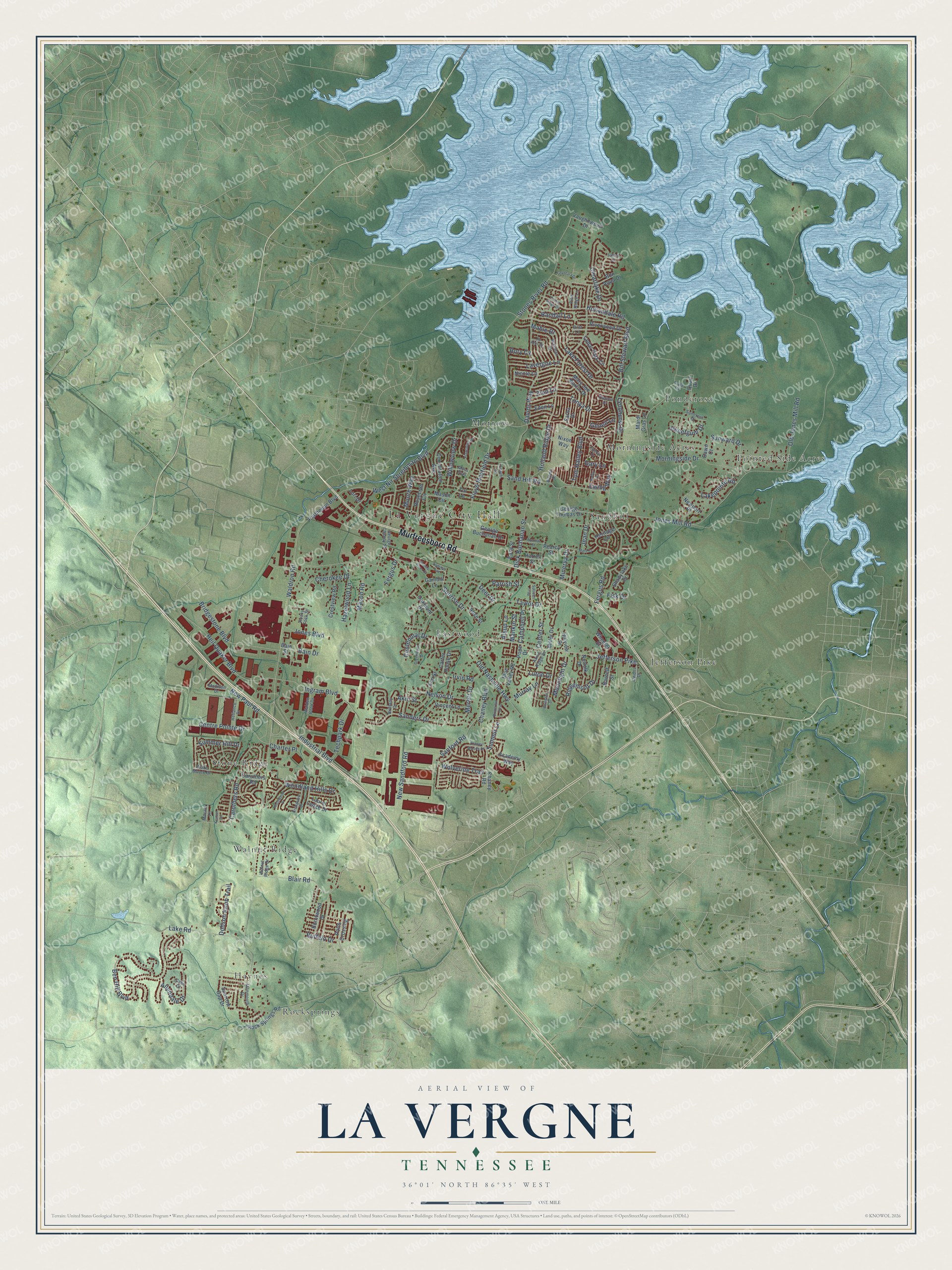
La Vergne, Tennessee Map Art
Building by building, with labeled streets and shaded relief.
12" x 18" Archival Matte Print
A Map of Home. A Work of Art.
Explore La Vergne, Tennessee from a whole new perspective. Created using aerial imagery and detailed geographic data, this map captures La Vergne building by building, with labeled streets, familiar landmarks, and shaded topographical relief that highlights the natural contours of the landscape.
Combining modern data with the timeless character of a vintage atlas, this map is just as interesting up close as it is beautiful on the wall. Whether you grew up in La Vergne, spent memorable years there, or call it home today, this unique map is a great way to celebrate a place that means something to you. Zoom in on the preview to look for your street, and then order a print to put your memories on the wall.
Three ways to hang it

Unframed archival matte, a black wood frame or a white wood frame.
Up close
Geography Worth Displaying
This map was created using accurate cartographic data and authoritative geographic sources, including the U.S. Geological Survey and the Census Bureau. The map brings together terrain, waterways, roads, and building detail. The majority of the streets are labeled, houses are accurately depicted, and the topography is derived from government sources. Combining local data with carefully composed color and shading leads to this beautifully detailed La Vergne artwork for your wall.
Rather than simply showing street outlines, we’ve included as many of the street names as we could reasonably fit on the map while keeping their names legible. Zoom in on the high resolution preview to see exactly what’s on the map. We truly set out to create a statement piece for anyone who loves La Vergne. So whether it’s for you, or a gift for someone you love, we hope this map of La Vergne brings back fond memories.
Read the story behind this map of La Vergne, Tennessee from 2026.

Find your street
Names on the La Vergne map
Every name below is printed on this map. Look for your street, your school, the park where you played, or the pond down the road.
Places and landmarks12
- La Vergne City Hall
- Rocksprings
- Pointed Side Acres
- Stone Ridge
- Sandhill
- Jefferson Pike
- Eastwood
- Walnut Ridge
- Morrow
- Ponderosa
- Morningside Acres
- Haynes
Streets and roads173
- Murfreesboro Road
- Waldron Road
- Jones Mill Road
- Stones River Road
- Hollandale Road
- Old Nashville Highway
- Mason Road
- Industrial Boulevard
- Davids Way
- Ben Hill Boulevard
- Sand Hill Road
- Holland Ridge Drive
- Bill Stewart Boulevard
- Sanford Road
- Blair Road
- Lake Forest Drive
- Heil Quaker Boulevard
- Floyd Mayfield Drive
- Fergus Road
- Lavergne Lane
- Sanders Drive
- Lake Road
- West Nir Shreibman Boulevard
- Bridgestone Boulevard
- Morningside Drive
- Tom Hailey Boulevard
- Carothers Road
- Woodland Hills Drive
- Chaney Boulevard
- New Paul Road
Show all 173 streets
- Center Street
- Dick Buchanan Street
- Wolverine Trail
- New Sandford Road
- Clearlake Drive
- Lyndhurst Drive
- Allendale Drive
- Ridgemont Drive
- Nelson Drive
- Centre Pointe Drive
- Centennial Drive
- Old Jones Mill Road
- Merritt Drive
- Taylor Drive
- Lakepointe Road
- Ingram Boulevard
- Cherokee Drive
- Sunrise Drive
- Moonlight Drive
- Hazelwood Lane
- Tonya Drive
- Irvin Road
- Techpark Drive
- Akin Street
- Willowview Drive
- Deer Drive
- Charter Place
- Sunward Drive
- Mable Drive
- Dobson Knob Trail
- Minerva Drive
- Ewing Way
- Moore Way
- Buffalo Drive
- Summer Hill Drive
- Sweetgum Drive
- Parrish Street
- Jones Boulevard
- Campbell Place
- Bain Drive
- Luton Drive
- Jean Drive
- Randall Lane
- Summit Lane
- Murray Lane
- Gary Lane
- Mankin Street
- Alsup Lane
- Fergus Drive
- Geneil Lane
- Zion Lane
- Fisk Drive
- Rory Cv
- Caruthers Road
- Cedar Park Circle
- Rosecran Circle
- Constitution Avenue
- George Buchanan Drive
- Mary Joe Martin Drive
- Mason Circle
- Pearcy Street
- George Thomas Drive
- Rock Springs Road
- Vincent Lane
- Elm Street
- Nicole Lane
- Heritage Circle
- Gambill Lane
- Burntwood Drive
- Riverwood Drive
- Bain Street
- Crestview Road
- Chaney Road
- Newport Place
- Quail Drive
- Academy Way
- Parthenon Boulevard
- Laurel Ledge Drive
- Potts Crossing
- Blue Valley Road
- Sparrow Gap Drive
- Bon Aqua Drive
- Hillview Drive
- Vaughnwood Drive
- Tal Lane
- Mardi Gras Lane
- Barnett Street
- Nixon Way
- Oakmont Drive
- Wheeler Street
- Eden Lane
- Norfolk Drive
- Shadylake Drive
- Easy Street
- Sarna Drive
- Carter House Drive
- Dawn Court
- Rose Street
- Harrell Street
- Miller Drive
- Pope Drive
- Lori Drive
- Suncrest Drive
- Blake Moore Drive
- Madison Drive
- Walnut Ridge Drive
- Waxman Drive
- Jo Ann Drive
- Reliance Drive
- Moss Trail
- Owens Drive
- Monmouth Drive
- Akins Ridge Drive
- Erwin Lane
- Walden Book Drive
- Brittany Drive
- George Chaney Street
- Pine Ridge Lane
- Macaw Lane
- Rocky Tock Street
- Cabe Court
- Arlene Drive
- Britt Lane
- Greenwood Drive
- Sunrise Avenue
- Abington Drive
- Forest Ridge Drive
- Sullivan Trail
- Knollwood Drive
- Plantation Drive
- Mars Street
- Chaney Woods Drive
- Nuview Street
- Briargrove Drive
- Phelissa Drive
- Chyntara Drive
- Butternut Trce
- Kestrel Circle
- Drake Road
- Stones River Court
- Bobby Drive
- Pamela Drive
- Suffolk Court
Names are listed as they appear on the printed map. Zoom into the product photos to find them.
About La Vergne, Tennessee
La Vergne is a city of 38,719 people in northern Rutherford County, southeast of Nashville. Settlers reached the land along Hurricane Creek and the Stones River in the late 18th century, and the early community was called Buchananville, where James B. Buchanan became postmaster in 1837. On August 23, 1852, the day the French-born physician Francois Lenard Gregoire de Roulhac de La Vergne died, the postmaster gave the post office his late friend's name.
The town was first incorporated on February 28, 1860, but the Civil War soon reached it. Skirmishes before the fighting at Murfreesboro in 1862 left much of the community burned, and no officials were elected after the war. With too few adults to form a board and write a town constitution, La Vergne lost its charter in 1881. It was incorporated again on February 29, 1972, when residents elected a city council and Vester Waldron became mayor.
- Firestone arrives in 1971Firestone, which later became Bridgestone, built a plant in La Vergne in 1971, a year before the city reincorporated. Ingram Content Group has facilities here, and Lightning Source runs a U.S. printing plant and headquarters in the city.
- Old Timers Day since 1972La Vergne marked its first Old Timers Day in 1972, the same year it reincorporated. The celebration grew into the yearly fall festival at Veterans Memorial Park, with food, craft vendors, a parade, entertainment and games for children.
- A sister city in FranceIn 1982 La Vergne became a sister city of La Vergne, France, a tie that goes back to the French name the post office took in 1852.
Keep exploring Tennessee
La Vergne is one of 640 Tennessee towns we've mapped. Every dot on the map is a print of its own.
The search covers every state, Tennessee first.
Near La Vergne
Order 2 or more town maps and save 10%. Shown in the size and finish you picked above, so they hang as a set.
- Smyrna 12" x 18" / Archival Matte Print $39.99
- Rocky Fork 12" x 18" / Archival Matte Print $39.99
- Rural Hill 12" x 18" / Archival Matte Print $39.99


More maps nearby: Nolensville, Gladeville, Blackman, Arrington and Walterhill.
The art of mapping a place
How This Map Was Made
Real places. Remarkable detail. Discover the layers that turn geographic data into a map of home.

The view from above
Aerial imagery reveals the character of the land: woodland, open fields, and the patterns of a place.

The shape of the land
Elevation data brings hills, valleys, and subtle changes in the landscape into view.

The details of home
Roads, waterways, and building footprints come together to make the map feel unmistakably local.

Geography becomes art
Considered color, shading, and typography bring the layers together in a map made for your wall.


Process illustrated with Mendon, Massachusetts. Aerial imagery: USDA NAIP. Terrain: USGS 3D Elevation Program. Map details and finished artwork: KNOWOL.
The Details
About This Print
Choose an archival matte print, or a black or white Ayous wood frame. The archival matte print is unframed.
Select your size and finish above to see the matching product image and price.
Materials & Craftsmanship
A contemporary map with the character of a classic atlas, printed on archival matte paper. Optional frames are made from Ayous wood.
Your printed map does not include the watermark shown in the full-map preview.
Shipping & Delivery
Free shipping within the United States. Every print is made to order in the USA.
Buying a gift? Add a note in your cart and we'll include it. We never put prices in the package.
Prints ship within 2 to 3 business days. Allow 7 to 10 days total from ordering for delivery. Timing may vary during holidays or periods of high order volume.
Read our shipping policy.
Returns and damaged prints
Each print is made to order. Change-of-mind refunds are not available after production.
If your print arrives damaged, misprinted or incorrect, contact support@knowol.com within 30 days of receiving it. Include your order number, photos and a description of the issue.
Read our full refund and replacement policy. For questions about your order, email support@knowol.com.