


Search for another town


Free U.S. delivery 7 to 10 days after you order
Magalia, California Map Art
Building by building, with labeled streets and shaded relief.
12" x 18" Archival Matte Print
A Map of Home. A Work of Art.
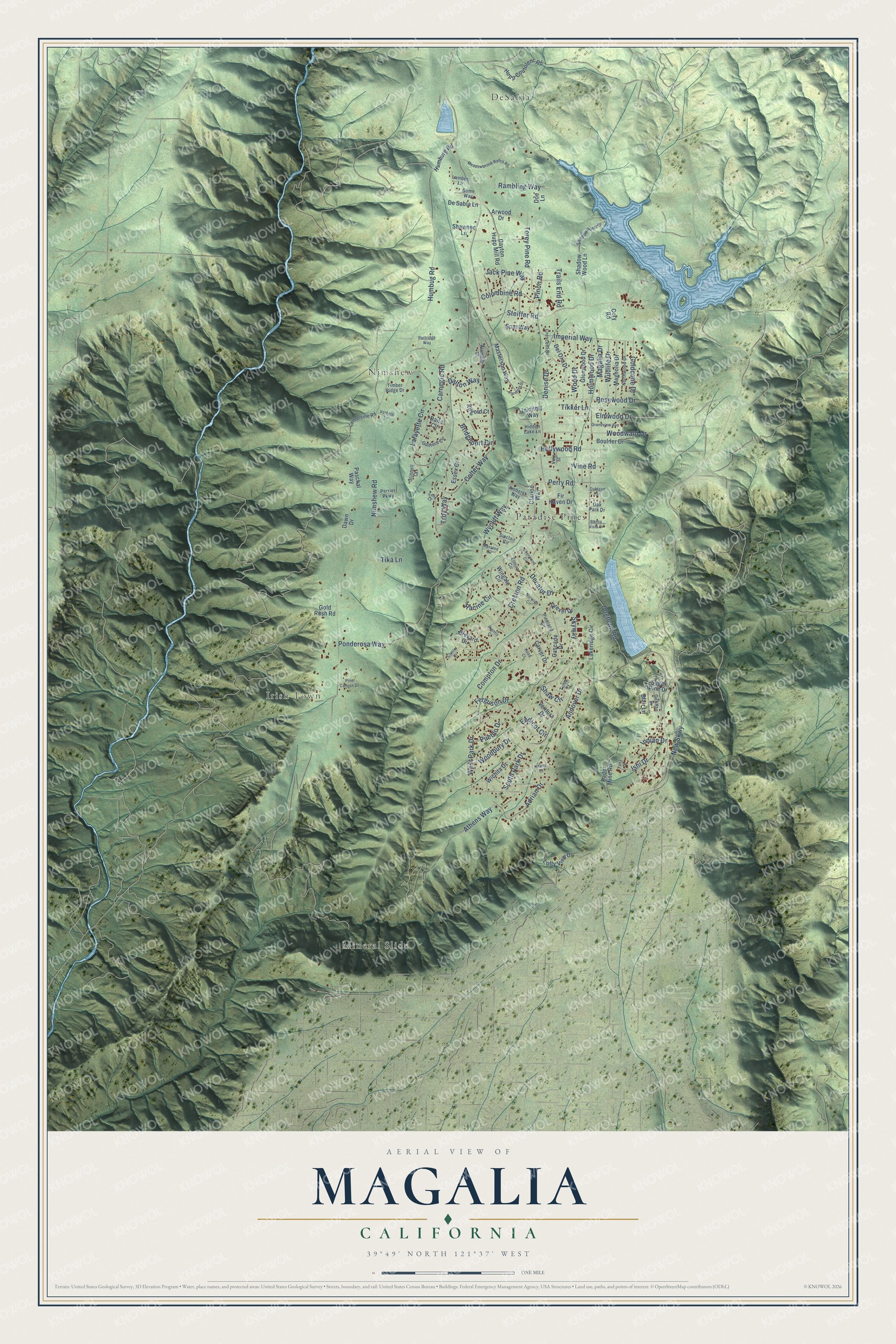
Explore Magalia, California from a whole new perspective. Created using aerial imagery and detailed geographic data, this map captures Magalia building by building, with labeled streets, familiar landmarks, and shaded topographical relief that highlights the natural contours of the landscape.
Combining modern data with the timeless character of a vintage atlas, this map is just as interesting up close as it is beautiful on the wall. Whether you grew up in Magalia, spent memorable years there, or call it home today, this unique map is a great way to celebrate a place that means something to you. Zoom in on the preview to look for your street, and then order a print to put your memories on the wall.
Three ways to hang it

Unframed archival matte, a black wood frame or a white wood frame.
Up close
Geography Worth Displaying
This map was created using accurate cartographic data and authoritative geographic sources, including the U.S. Geological Survey and the Census Bureau. The map brings together terrain, waterways, roads, and building detail. The majority of the streets are labeled, houses are accurately depicted, and the topography is derived from government sources. Combining local data with carefully composed color and shading leads to this beautifully detailed Magalia artwork for your wall.
Rather than simply showing street outlines, we’ve included as many of the street names as we could reasonably fit on the map while keeping their names legible. Zoom in on the high resolution preview to see exactly what’s on the map. We truly set out to create a statement piece for anyone who loves Magalia. So whether it’s for you, or a gift for someone you love, we hope this map of Magalia brings back fond memories.
Read the story behind this map of Magalia, California from 2026.

Find your street
Names on the Magalia map
Every name below is printed on this map. Look for your street, your school, the park where you played, or the pond down the road.
Places and landmarks5
- DeSabla
- Mineral Slide
- Nimshew
- Irish Town
- Paradise Pines
Streets and roads124
- Nimshew Road
- Skyway
- Ponderosa Way
- Steiffer Road
- Carnegie Road
- Athens Way
- Andover Drive
- South Park Drive
- Humbug Road
- Holmwood Drive
- Colter Way
- West Park Drive
- Wycliff Way
- Dogtown Road
- Creston Road
- Wood Drive
- Imperial Way
- New Skwy
- Jack Pine Way
- Rosewood Drive
- Woodward Drive
- Torey Pine Road
- Elmwood Drive
- Rambling Way
- Ferguson Drive
- Tikker Lane
- Adrian Drive
- Bridgeport Circle
- Columbine Road
- Hollywood Road
Show all 124 streets
- Ishi Drive
- Tika Lane
- Lafayette Circle
- Racine Circle
- Trails End Road
- Perry Road
- Goldcone Drive
- Wildlife Drive
- Endicot Circle
- Indian Drive
- Compton Drive
- Shaw Circle
- Woodbury Drive
- Magalia Drive
- Pinon Road
- Vine Road
- Decatur Drive
- Pueblo Drive
- Dalton Way
- Denise Drive
- Troy Way
- Shadow Wood Lane
- Del Oro Drive
- Hupp Coutolenc Road
- Wingate Circle
- Dayton Hupp Mill Road
- Lakeridge Circle
- Bader Mine Road
- Glenwood Drive
- Boulder Drive
- Masterson Way
- Magnolia Drive
- Sugar Pine Drive
- Brevard Circle
- Drexel Drive
- Cascade Drive
- Wichita Drive
- Carver Drive
- Clarion Way
- Lofty View Drive
- Paschal Way
- Kilgord Court
- Dana Circle
- Humburg Road
- Gold Rush Road
- De Sabla Lane
- Dawn Drive
- Essex Court
- Shawnee Lane
- Ididitmy Way
- Spar Way
- Fir Haven Drive
- Ventura Drive
- Arwood Drive
- Blair Lane
- Cory Road
- Doe Lane
- Centerville Road
- Shadowwood Drive
- Sinclair Circle
- Timber Ridge Drive
- Elmira Circle
- Northwood Drive
- Crescent Drive
- Guilford Circle
- Pineland Circle
- Vine Street
- Perrier Parkway
- Amherst Way
- Lambert Lane
- Gilfillan Drive
- Klamath Court
- Some Way
- Grinnell Court
- Hidden Lake Lane
- Oak Park Drive
- Tulsa Court
- Meadowbrook Ranch Road
- Norwich Circle
- Sherwood Circle
- Grandview Avenue
- Manatee Circle
- Partridge Way
- Fremont Drive
- Pine Canyon Drive
- Vorheis Lane
- Cluster Court
- Oakland Drive
- Buena Vista Drive
- Prentis Court
- Marin Court
- Hood Court
- Lane Court
- Yana Court
Names are listed as they appear on the printed map. Zoom into the product photos to find them.
About Magalia, California
Magalia is a community of 7,795 people in Butte County, California. It started as a mining camp after the Gold Rush of 1849, and its first name was Mountain View. In 1850 someone began breeding dogs there, and the miners started calling the camp Dogtown.
A post office opened in 1857 and served both Dogtown and the neighboring settlement of Mill City, and over the years the two places grew into one town. In 1861 the town took the name Magalia, from the Latin word for cottages. Butte Mills is another of its former names.
- The Dogtown Nugget, 1859On April 12, 1859, miners at the Willard Claim, a hydraulic operation in the Feather River Canyon northeast of town, pulled out a gold nugget weighing 54 pounds. No bigger nugget was known anywhere in the world at the time. People called it the Dogtown Nugget, and the find made the town famous.
- The Camp Fire of 2018The Camp Fire, a wildfire that broke out on November 8, 2018, did heavy damage in Magalia. By December 13 the Butte County Sheriff's Department had counted at least seven deaths in the community. Some survivors waited out the flames at a Baptist church on the only evacuation route north of the ridge. The census counted 11,310 people here in 2010 and 7,795 in 2020.
- Cedar and pine forestMost of Magalia sits on deep reddish-brown loam, and that soil grows forests of tall incense cedar and bull pine. Black-tailed deer, raccoons and grey squirrels live in these woods, and the rough-skinned newt reaches the southern edge of its range in inland California near Magalia.
Keep exploring California
Magalia is one of 1,990 California towns we've mapped. Every dot on the map is a print of its own.
The search covers every state, California first.
Near Magalia
Order 2 or more town maps and save 10%. Shown in the size and finish you picked above, so they hang as a set.
- Paradise 12" x 18" / Archival Matte Print $39.99
- Concow 12" x 18" / Archival Matte Print $39.99
- Forest Ranch 12" x 18" / Archival Matte Print $39.99
More maps nearby: Stirling City, Butte Creek Canyon, Cohasset, Yankee Hill and Butte Valley.
The art of mapping a place
How This Map Was Made
Real places. Remarkable detail. Discover the layers that turn geographic data into a map of home.

The view from above
Aerial imagery reveals the character of the land: woodland, open fields, and the patterns of a place.

The shape of the land
Elevation data brings hills, valleys, and subtle changes in the landscape into view.

The details of home
Roads, waterways, and building footprints come together to make the map feel unmistakably local.

Geography becomes art
Considered color, shading, and typography bring the layers together in a map made for your wall.


Process illustrated with Mendon, Massachusetts. Aerial imagery: USDA NAIP. Terrain: USGS 3D Elevation Program. Map details and finished artwork: KNOWOL.
The Details
About This Print
Choose an archival matte print, or a black or white Ayous wood frame. The archival matte print is unframed.
Select your size and finish above to see the matching product image and price.
Materials & Craftsmanship
A contemporary map with the character of a classic atlas, printed on archival matte paper. Optional frames are made from Ayous wood.
Your printed map does not include the watermark shown in the full-map preview.
Shipping & Delivery
Free shipping within the United States. Every print is made to order in the USA.
Buying a gift? Add a note in your cart and we'll include it. We never put prices in the package.
Prints ship within 2 to 3 business days. Allow 7 to 10 days total from ordering for delivery. Timing may vary during holidays or periods of high order volume.
Read our shipping policy.
Returns and damaged prints
Each print is made to order. Change-of-mind refunds are not available after production.
If your print arrives damaged, misprinted or incorrect, contact support@knowol.com within 30 days of receiving it. Include your order number, photos and a description of the issue.
Read our full refund and replacement policy. For questions about your order, email support@knowol.com.