


Search for another town


Free U.S. delivery 7 to 10 days after you order
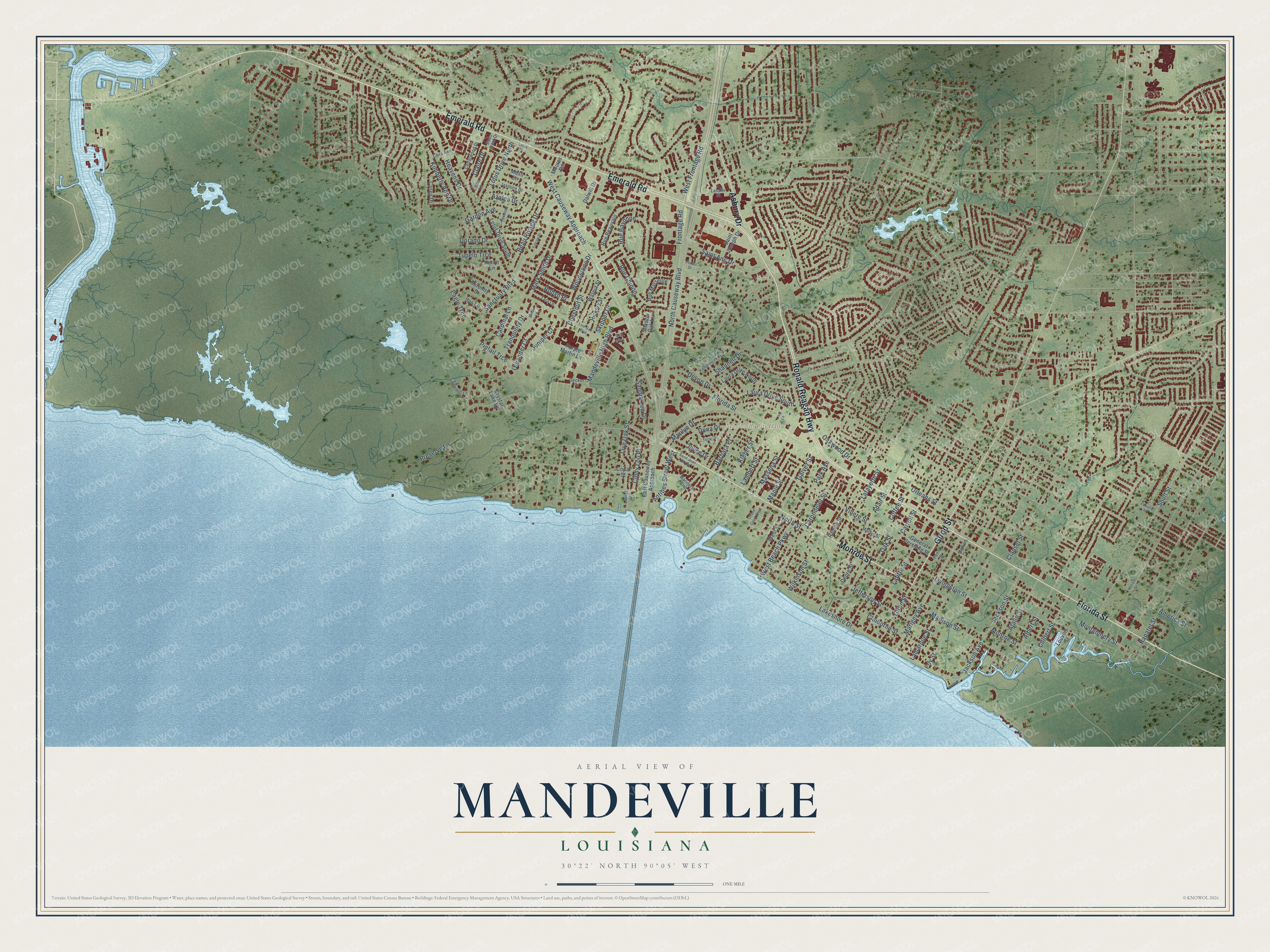
Mandeville, Louisiana Map Art
Building by building, with labeled streets and shaded relief.
12" x 18" Archival Matte Print
A Map of Home. A Work of Art.
Explore Mandeville, Louisiana from a whole new perspective. Created using aerial imagery and detailed geographic data, this map captures Mandeville building by building, with labeled streets, familiar landmarks, and shaded topographical relief that highlights the natural contours of the landscape.
Combining modern data with the timeless character of a vintage atlas, this map is just as interesting up close as it is beautiful on the wall. Whether you grew up in Mandeville, spent memorable years there, or call it home today, this unique map is a great way to celebrate a place that means something to you. Zoom in on the preview to look for your street, and then order a print to put your memories on the wall.
Three ways to hang it

Unframed archival matte, a black wood frame or a white wood frame.
Up close
Geography Worth Displaying
This map was created using accurate cartographic data and authoritative geographic sources, including the U.S. Geological Survey and the Census Bureau. The map brings together terrain, waterways, roads, and building detail. The majority of the streets are labeled, houses are accurately depicted, and the topography is derived from government sources. Combining local data with carefully composed color and shading leads to this beautifully detailed Mandeville artwork for your wall.
Rather than simply showing street outlines, we’ve included as many of the street names as we could reasonably fit on the map while keeping their names legible. Zoom in on the high resolution preview to see exactly what’s on the map. We truly set out to create a statement piece for anyone who loves Mandeville. So whether it’s for you, or a gift for someone you love, we hope this map of Mandeville brings back fond memories.
Read the story behind this map of Mandeville, Louisiana from 2026.

Find your street
Names on the Mandeville map
Every name below is printed on this map. Look for your street, your school, the park where you played, or the pond down the road.
Places and landmarks1
- Mandeville City Hall
Streets and roads136
- Ronald Reagan Highway
- Emerald Road
- Monroe Street
- Florida Street
- Girod Street
- Asbury Drive
- North Causeway Boulevard
- West Causeway Approach
- Sanctuary Boulevard
- Villere Street
- Montgomery Street
- Marigny Avenue
- Orleans Street
- Lakeshore Drive
- Jefferson Street
- Livingston Street
- Claiborne Street
- Cardinal Lane
- Wilkinson Street
- Madison Street
- Lafayette Street
- Carondelet Street
- Heavens Drive
- Lafitte Street
- Rue Bayonne
- Coffee Street
- Massena Street
- Frontage Road
- Foy Street
- Carroll Street
Show all 136 streets
- Lamarque Street
- Preserve Lane
- Antibes Street West
- Jackson Avenue
- Jackson Street
- Atalin Street
- Kleber Street
- Devon Drive
- Garden Avenue
- Soult Street
- Adair Street
- West Beach Parkway
- Laura Drive South
- Mark Smith Drive
- Tupelo Trce
- Pintail Trce
- Saint Ann Drive
- Beau Rivage Drive
- Mandeville High Boulevard
- Rue Chinon
- Live Oak Street
- Albert Street
- Lotus Drive North
- Marilyn Drive
- Cindy Lou Place
- West Frontage Road
- Galvez Street
- Tranquility Drive
- Oleander Court
- Colbert Street
- Chestnut Street
- Barbara Place
- Lambert Street
- Park Avenue
- Sandra Lee Drive
- Oakwood Drive
- Kimberly Ann Drive
- America Street
- Juniper Court
- Maple Street
- Rapatel Street
- Woodstone Drive
- Skipper Drive
- Clausel Street
- Shaunell Drive
- Dona Drive
- Eagle Trce
- Claire Drive
- Azalea Drive
- Joyce Drive
- Robyn Place
- Dorado Drive
- Oak Street
- North Street
- Purple Martin Lane
- East Causeway Approach
- Rue Beauvais
- Laura Drive North
- Ramon Street
- Lotus Drive South
- Walnut Street
- Dalwill Drive
- Moss Lane
- Hickory Street
- West Street
- Serenity Drive
- Shadow Oak Lane
- Rue Marseille
- Saint Joseph Drive
- General Pershing Street
- Casey Drive
- Depre Street
- Copal Street
- Ibis Lane
- Crystal Lake Lane
- Moores Road
- Louvois Street
- Heron Lane
- Mariners Boulevard
- Cedarwood Drive
- Libby Lane
- Mathis Street
- Penn Street
- Jasmine Drive
- Tara Lane
- Lasalle Street
- Sawmill Lane
- Libra Avenue
- Beau West Drive
- Decker Drive
- Jane Drive
- Laurel Street
- Chase Court West
- Molitor Street
- Katherine Parkway
- Live Oak Boulevard
- Hyacinth Lane
- Falcon Drive
- Saint Jean de Luz
- Lotus Drive
- Lisa Lane
- Labarre Street
- Magnolia Street
- Orchid Lane
- Forest Drive
- Oak Alley
Names are listed as they appear on the printed map. Zoom into the product photos to find them.
About Mandeville, Louisiana
Mandeville is a city of 13,192 people in St. Tammany Parish, on the north shore of Lake Pontchartrain, straight across the water from New Orleans. In 1829 Bernard Xavier de Marigny de Mandeville, a New Orleans planter and legislator from one of Louisiana's leading families, bought a large tract east of Bayou Castine and turned it into a plantation called Fontainebleau. Congress confirmed his title to the land with a private act on March 15, 1832.
In 1834 Marigny mapped out a town on the ground west of the bayou and auctioned the lots in New Orleans, selling the place to city people as a resort across the lake. Mandeville was incorporated in 1840, and well-off families came each summer to escape the heat. Once daily steamboats began running in the middle of the century, middle-class New Orleanians followed on weekends. The resort trade faded by the 1940s, when cars could carry city people farther away.
“Some built summer homes with broad galleries from which they could catch the lake breezes.”
- Summer houses on Lakeshore DriveMany of the early summer homes still stand along Lakeshore Drive. The house at 1721, stucco over brick-between-posts with a Creole plan, a front gallery and a rear loggia, dates to about 1835, and its side galleries were added later in the century. The raised Greek Revival house at 1717, built around a central hall, dates to about 1840.
- The Dew Drop Hall, 1895A Black mutual aid society, organized in town on May 5, 1885, put up a small gable-fronted frame hall at 432 Lamarque Street in 1895. Buddy Petit, Bunk Johnson and Kid Ory played its dances, and Black social life in town revolved around it until about 1940. The society broke up in 1980. In 2000 the hall joined the National Register, and the city bought it and renamed it the Dew Drop Jazz and Social Hall.
- Early jazz across the lakeBands played on the steamboats crossing the lake and at Mandeville's pavilions and dance halls, so the town was one of the first places outside New Orleans to hear the new jazz. Papa Celestin, George Lewis and Edmond Hall were among the regulars. Ruby's Roadhouse, once Buck's Brown Derby and then Ruby's Rendezvous, has kept the music going since the 1920s.
- The Motor RoadStarting in 1909, an interurban line that locals called the Motor Road linked the steamship pier on the Mandeville lakefront with Abita Springs and Covington. Its owner, a railway and ferry company named for St. Tammany and New Orleans, used the line's powerhouse to light the town's electric streetlights too. Those lights went dark when the line was scrapped in 1918.
- A road across the lakeIn 1956 cars first crossed the Lake Pontchartrain Causeway, whose northern end sits at Mandeville, and a second span followed in 1969. People who worked in New Orleans began settling here, and by the 1990s Mandeville and the land around it were at the center of western St. Tammany Parish's suburban boom.
Keep exploring Louisiana
Mandeville is one of 594 Louisiana towns we've mapped. Every dot on the map is a print of its own.
The search covers every state, Louisiana first.
Near Mandeville
Order 2 or more town maps and save 10%. Shown in the size and finish you picked above, so they hang as a set.
- Lewisburg 12" x 18" / Archival Matte Print $39.99
- Madisonville 12" x 18" / Archival Matte Print $39.99
- Covington 12" x 18" / Archival Matte Print $39.99


More maps nearby: Abita Springs, Lacombe, Carolyn Park, Folsom and Slidell.
The art of mapping a place
How This Map Was Made
Real places. Remarkable detail. Discover the layers that turn geographic data into a map of home.

The view from above
Aerial imagery reveals the character of the land: woodland, open fields, and the patterns of a place.

The shape of the land
Elevation data brings hills, valleys, and subtle changes in the landscape into view.

The details of home
Roads, waterways, and building footprints come together to make the map feel unmistakably local.

Geography becomes art
Considered color, shading, and typography bring the layers together in a map made for your wall.


Process illustrated with Mendon, Massachusetts. Aerial imagery: USDA NAIP. Terrain: USGS 3D Elevation Program. Map details and finished artwork: KNOWOL.
The Details
About This Print
Choose an archival matte print, or a black or white Ayous wood frame. The archival matte print is unframed.
Select your size and finish above to see the matching product image and price.
Materials & Craftsmanship
A contemporary map with the character of a classic atlas, printed on archival matte paper. Optional frames are made from Ayous wood.
Your printed map does not include the watermark shown in the full-map preview.
Shipping & Delivery
Free shipping within the United States. Every print is made to order in the USA.
Buying a gift? Add a note in your cart and we'll include it. We never put prices in the package.
Prints ship within 2 to 3 business days. Allow 7 to 10 days total from ordering for delivery. Timing may vary during holidays or periods of high order volume.
Read our shipping policy.
Returns and damaged prints
Each print is made to order. Change-of-mind refunds are not available after production.
If your print arrives damaged, misprinted or incorrect, contact support@knowol.com within 30 days of receiving it. Include your order number, photos and a description of the issue.
Read our full refund and replacement policy. For questions about your order, email support@knowol.com.