


Search for another town


Free U.S. delivery 7 to 10 days after you order
Slidell, Louisiana Map Art
Building by building, with labeled streets and shaded relief.
12" x 18" Archival Matte Print
A Map of Home. A Work of Art.
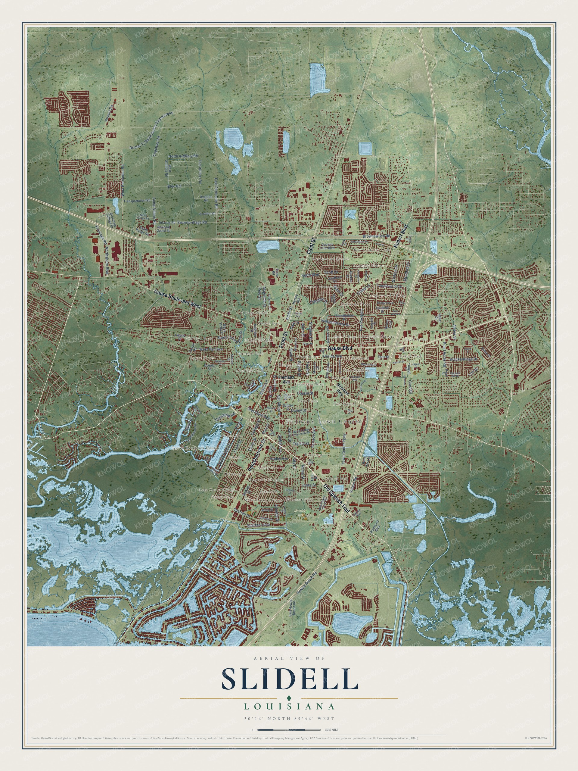
Explore Slidell, Louisiana from a whole new perspective. Created using aerial imagery and detailed geographic data, this map captures Slidell building by building, with labeled streets, familiar landmarks, and shaded topographical relief that highlights the natural contours of the landscape.
Combining modern data with the timeless character of a vintage atlas, this map is just as interesting up close as it is beautiful on the wall. Whether you grew up in Slidell, spent memorable years there, or call it home today, this unique map is a great way to celebrate a place that means something to you. Zoom in on the preview to look for your street, and then order a print to put your memories on the wall.
Three ways to hang it

Unframed archival matte, a black wood frame or a white wood frame.
Up close
Geography Worth Displaying
This map was created using accurate cartographic data and authoritative geographic sources, including the U.S. Geological Survey and the Census Bureau. The map brings together terrain, waterways, roads, and building detail. The majority of the streets are labeled, houses are accurately depicted, and the topography is derived from government sources. Combining local data with carefully composed color and shading leads to this beautifully detailed Slidell artwork for your wall.
Rather than simply showing street outlines, we’ve included as many of the street names as we could reasonably fit on the map while keeping their names legible. Zoom in on the high resolution preview to see exactly what’s on the map. We truly set out to create a statement piece for anyone who loves Slidell. So whether it’s for you, or a gift for someone you love, we hope this map of Slidell brings back fond memories.
Read the story behind this map of Slidell, Louisiana from 2026.

Find your street
Names on the Slidell map
Every name below is printed on this map. Look for your street, your school, the park where you played, or the pond down the road.
Places and landmarks40
- Fremaux Town Center
- Fritchie Park
- New Country Club
- Robert Park
- Carolyn Park
- Bayou Bonfouca Estates
- Forest Manor
- Pinecrest
- Tanglewood Village
- Brugier
- Yester Oaks
- Pine Shadows
Show all 40 places
- Palm Lake
- Brookwood Estates
- Bon Village
- Chamale Cove
- Abney Estates
- Village North
- Park Place
- Delwood
- Eastridge
- Pearl Acres
- Audubon Place
- Country Manor
- Westchester Estates
- Slidell Heights
- Central Park
- Charleston Square
- Salmen
- Broadmoor
- Forest Pines
- Fountainbleau
- Oakwood
- Fountain Park
- Pine Forest
- Lakewood
- Magnolia Heights
- Windsor Place
- North End
- Lake Shore Village
Streets and roads157
- Gause Boulevard
- Old Spanish Trail
- Front Street
- Gause Boulevard West
- Robert Boulevard
- Pontchartrain Drive
- Terrace Avenue
- Sixth Street
- Canulette Road
- Cleveland Avenue
- East Perimeter Road
- Doctor Tj Smith Senior Expressway
- Howze Beach Road
- First Street
- Airport Road
- Spartan Drive
- North Boulevard
- Engineer Road
- Ninth Street
- Rue Rochelle
- Brownswitch Road
- Town Center Parkway
- Sgt Alfred Drive
- West Hall Avenue
- Florida Avenue
- Northshore Boulevard
- Camp Villere Road
- Carey Street
- Eighth Street
- Daney Street
Show all 157 streets
- Grafton Drive
- Brownsvillage Road
- Tenth Street
- Oriole Lane
- Pine Street
- Bayou Lane
- Magnolia Street
- Second Street
- Cousin Street
- Spartan Loop
- Saint Christopher Street
- College Street
- Igloo Road
- Tanglewood Drive
- Rama Street
- Lopez Street
- Independence Drive
- Frontage Road
- Pearl Acres Road
- Breckenridge Drive
- West Perimeter Road
- Dale Drive
- South Palm Drive
- Voters Road
- Slidell Avenue
- North Artillery Road
- Hailey Avenue
- Fountain Drive
- Stadium Drive
- Harris Street
- Palm Drive
- Amber Street
- Annette Drive
- Tupelo Street
- Island Drive
- Addis Street
- Carol Drive
- Stratford Drive
- Scott Drive
- City Drive
- Dijon Drive
- Lori Drive
- Fremaux Avenue
- Shortcut Highway
- Bonfouca Drive
- Audubon Street
- Country Club Boulevard
- Infantry Road
- Fifth Street
- Cardinal Drive
- East Howze Beach Road
- Sunset Drive
- Pearl Street
- Constitution Drive
- Cawthorn Drive
- Berkley Street
- Maris Stella Street
- Broadmoor Drive
- Transportation Road
- West Artillery Road
- East Artillery Road
- Bella Sera Lane
- Grantham College Drive
- Liberty Drive
- Rue Verand
- Pinehurst Boulevard
- Carroll Road
- Nickel Loop
- Schley Street
- South Range Road
- Mary Drive
- Aviation Road
- Aviation Drive
- National Guard Road
- Anna Street
- Dillon Drive
- Yaupon Drive
- Monaco Drive
- Harvey Avenue
- Queens Lane
- Faith Drive
- Oceola Street
- Taos Street
- Rebel Drive
- Stone Road
- West Howze Beach Road
- Carnation Street
- Seventh Street
- Martin Luther King Junior Drive
- Asheville Drive
- Carollo Drive
- Huntington Drive
- Chamale Cv
- Amanda Drive
- North Range Road
- Desoto Street
- Christian Lane
- Briargrove Drive
- Kasey Street
- Tyler Street
- Orchard Hill Drive
- Marche Boulevard
- Caruso Boulevard
- Tiger Drive
- 14th Street
- Tracy Drive
- Fern Street
- Oak Lane
- Eastwood Drive
- Westlawn Drive
- McKinney Road
- Charlie Drive
- Maplewood Drive
- Natchez Drive
- Loop Drive
- Beth Drive
- Guzman Street
- West Camellia Drive
- Hoover Drive
- Codifer Street
- Nottingham Drive
- Jaguar Drive
- Village Street
- Bywater Drive
- Pine Cone Lane
- Indiana Avenue
- Elissa Lane
Names are listed as they appear on the printed map. Zoom into the product photos to find them.
About Slidell, Louisiana
Slidell is a city of 28,781 people in St. Tammany Parish, near the northeast shore of Lake Pontchartrain. The town grew up in 1882 and 1883 as crews built the New Orleans and Northeastern Railroad, the line from New Orleans to Meridian, Mississippi, and railroad surveyors laid out its streets in 1883. It took the name of John Slidell (1793-1871), a U.S. congressman who became the Confederacy's ambassador to France and whose son-in-law had put major money into the railroad.
The Louisiana legislature chartered the town in 1888. Real growth had begun two years earlier, in 1886, when Fritz Salmen, an immigrant from Switzerland, opened a brickworks here. He and his brothers, Jacob and Albert, built it into the Salmen Brick and Lumber Company, which kept running until the 1920s.
- The house by the brickyardFritz Salmen built a one-and-a-half-story house on Cleveland Avenue facing his brickyard, and people say he watched the yard from the parlor's bay window. The house blends Queen Anne and Colonial Revival styles. A kitchen ell was added by 1906, and the east gallery became a sun room in 1917.
- The depot and the ArcadeThe railroad depot at 1809 Front Street went up in 1913, a long brick building under a hipped roof, its eaves held up by big ornamental brackets. The Arcade Theater on Carey Street followed in 1927, built of brick covered in stucco under a tile roof with a light Mediterranean look. Both stand in the Olde Towne District, and they joined the National Register in 1996 and 1997.
- From creosote plant to parkAround 1910, as Slidell's industry grew, a large creosote plant went up. Fire destroyed it in 1915, and it was rebuilt on Bayou Lane, closer to water and a fire station. For years creosote fouled the bayou, which many residents drank from. Abandoned in 1986, the plant was named an EPA Superfund site, and crews dredged the canal and burned the waste until the cleanup ended in the 1990s. Heritage Park and a boat launch were later built there.
- A suburb of the space ageIn the 1960s NASA built the Michoud Assembly Facility in New Orleans and a computer center on Gause Boulevard, and the Stennis Space Center opened just to the east in Hancock County, Mississippi. Slidell's population nearly tripled in 10 years. With long bridges carrying traffic over the lake to eastern New Orleans, it became the parish's first true suburb, home to space workers and many others.
Keep exploring Louisiana
Slidell is one of 594 Louisiana towns we've mapped. Every dot on the map is a print of its own.
The search covers every state, Louisiana first.
Near Slidell
Order 2 or more town maps and save 10%. Shown in the size and finish you picked above, so they hang as a set.
- Alton 12" x 18" / Archival Matte Print $39.99
- Carolyn Park 12" x 18" / Archival Matte Print $39.99
- Eden Isle 12" x 18" / Archival Matte Print $39.99


More maps nearby: Pearl River, Lacombe, New Orleans, Abita Springs and Lewisburg.
The art of mapping a place
How This Map Was Made
Real places. Remarkable detail. Discover the layers that turn geographic data into a map of home.

The view from above
Aerial imagery reveals the character of the land: woodland, open fields, and the patterns of a place.

The shape of the land
Elevation data brings hills, valleys, and subtle changes in the landscape into view.

The details of home
Roads, waterways, and building footprints come together to make the map feel unmistakably local.

Geography becomes art
Considered color, shading, and typography bring the layers together in a map made for your wall.


Process illustrated with Mendon, Massachusetts. Aerial imagery: USDA NAIP. Terrain: USGS 3D Elevation Program. Map details and finished artwork: KNOWOL.
The Details
About This Print
Choose an archival matte print, or a black or white Ayous wood frame. The archival matte print is unframed.
Select your size and finish above to see the matching product image and price.
Materials & Craftsmanship
A contemporary map with the character of a classic atlas, printed on archival matte paper. Optional frames are made from Ayous wood.
Your printed map does not include the watermark shown in the full-map preview.
Shipping & Delivery
Free shipping within the United States. Every print is made to order in the USA.
Buying a gift? Add a note in your cart and we'll include it. We never put prices in the package.
Prints ship within 2 to 3 business days. Allow 7 to 10 days total from ordering for delivery. Timing may vary during holidays or periods of high order volume.
Read our shipping policy.
Returns and damaged prints
Each print is made to order. Change-of-mind refunds are not available after production.
If your print arrives damaged, misprinted or incorrect, contact support@knowol.com within 30 days of receiving it. Include your order number, photos and a description of the issue.
Read our full refund and replacement policy. For questions about your order, email support@knowol.com.