
Search for another town


Free U.S. delivery 7 to 10 days after you order
Maryville, Tennessee Map Art
Building by building, with labeled streets and shaded relief.
12" x 18" Archival Matte Print
A Map of Home. A Work of Art.
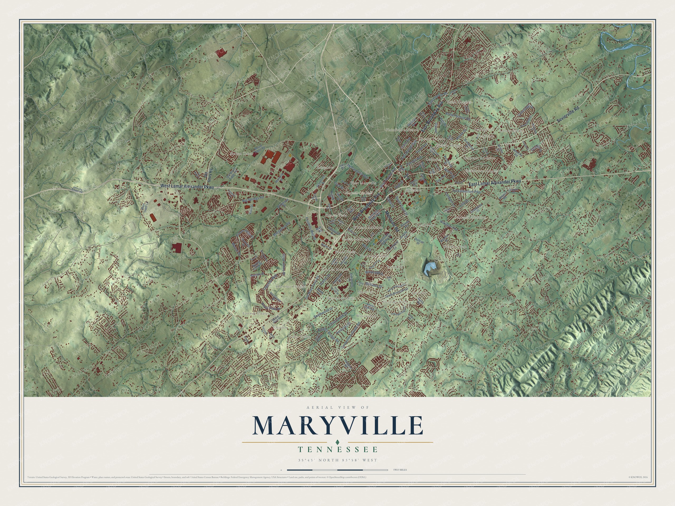
Explore Maryville, Tennessee from a whole new perspective. Created using aerial imagery and detailed geographic data, this map captures Maryville building by building, with labeled streets, familiar landmarks, and shaded topographical relief that highlights the natural contours of the landscape.
Combining modern data with the timeless character of a vintage atlas, this map is just as interesting up close as it is beautiful on the wall. Whether you grew up in Maryville, spent memorable years there, or call it home today, this unique map is a great way to celebrate a place that means something to you. Zoom in on the preview to look for your street, and then order a print to put your memories on the wall.
Three ways to hang it

Unframed archival matte, a black wood frame or a white wood frame.
Up close
Geography Worth Displaying
This map was created using accurate cartographic data and authoritative geographic sources, including the U.S. Geological Survey and the Census Bureau. The map brings together terrain, waterways, roads, and building detail. The majority of the streets are labeled, houses are accurately depicted, and the topography is derived from government sources. Combining local data with carefully composed color and shading leads to this beautifully detailed Maryville artwork for your wall.
Rather than simply showing street outlines, we’ve included as many of the street names as we could reasonably fit on the map while keeping their names legible. Zoom in on the high resolution preview to see exactly what’s on the map. We truly set out to create a statement piece for anyone who loves Maryville. So whether it’s for you, or a gift for someone you love, we hope this map of Maryville brings back fond memories.
Read the story behind this map of Maryville, Tennessee from 2026.

Find your street
Names on the Maryville map
Every name below is printed on this map. Look for your street, your school, the park where you played, or the pond down the road.
Places and landmarks34
- Maryville City Hall
- Fairway Estates
- Montvue
- Mount Tabor
- Oakhurst
- Oaklawn Addition
- Cherokee Heights
- Briarcliff
- Windsor Park
- Westfields
- Hillsdale
- Bungalow
Show all 34 places
- Grandview Heights
- Green Valley
- Wimbledon
- Plainfield addition
- Everett Heights
- Heritage Hills
- Eastover
- Tee Lee Heights
- Willard Addition
- Asbury Estates
- Creekwood
- Westwood Hills
- Turnberry Vistas
- West Maryville
- Sunset View
- Belmont Addition
- Lonas Addition
- Fairview
- Buena Vista
- Scenic Terrace
- Bittle Heights
- Springfield
Streets and roads137
- West Broadway Avenue
- Sevierville Road
- East Broadway Avenue
- West Lamar Alexander Parkway
- East Lamar Alexander Parkway
- Montvale Road
- Wilcox Street
- South Court Street
- Old Niles Ferry Road
- Big Springs Road
- Morganton Road
- Brown School Road
- Tuckaleechee Pike
- Foothills Mall Drive
- McCammon Avenue
- Carpenters Grade Road
- Legends Way
- East Harper Avenue
- Everett Avenue
- Southwood Drive
- Scenic Drive
- West Harper Avenue
- Cross Creek Drive
- Knights Bridge Road
- Saint Johns Drive
- Best Street
- Helmsley Court
- Foch Street
- Royal Oaks Drive
- Mercer Drive
Show all 137 streets
- East Lincoln Road
- Cates Street
- Jett Road
- Irwin Avenue
- Crestridge Drive
- Windridge Drive
- Lambert Lane
- Alpine Drive
- Williams Street
- High Street
- Lisa Drive
- Old Glory Road
- Burchfield Street
- Jones Avenue
- Montvale Station Road
- Grandview Drive
- Wilkinson Pike
- Old Mount Tabor Road
- Amerine Road
- Leconte Drive
- Elsborn Ridge Road
- Linda Lane
- Sherwood Drive
- Madison Avenue
- Turnberry Lane
- Ross Drive
- Whitecrest Drive
- Dunlap Street
- Broady Lane
- Masters Drive
- Bridgeway Drive
- South Briarcliff Circle
- White Oak Avenue
- Windsor Drive
- Crest Road
- Brentwood Drive
- Forest Avenue
- Waters Road
- Mountain View Avenue
- Duncan Drive
- Spring Creek Street
- Southcliff Drive
- Farris Road
- Daventry Drive
- Mall Road
- Mount Tabor Road
- Innisbrook Drive
- Simerly Street
- Barnes Avenue
- Elm Drive
- Keller Lane
- Ruscello Drive
- West Odell Lane
- Raulston Road
- Andrea Drive
- Mustang Drive
- Waters Place
- Turner Street
- Short Street
- Belfast Street
- Doll Avenue
- East Street
- David Lane
- Oak Street
- Montgomery Lane
- South Heritage Drive
- Market Place Drive
- Laurie Street
- Willard Street
- North Briarcliff Circle
- Northfield Drive
- Dunbarton Drive
- Front Street
- Manning Lane
- Brookwood Lane
- Camellia Trce
- Oxford Hills Drive
- Homestead Court
- John Lee Brewer Road
- Fairview Drive
- Lord Avenue
- Celtic Road
- Nicole Court
- Effler Road
- Ivy Street
- Watkins Road
- South Everett High Road
- Sandy Springs Road
- Argonne Drive
- Tapoco Avenue
- Hudson Street
- Wright Road
- Genesis Street
- Wade Circle
- Kelton Lane
- Olympia Drive
- Ellington Drive
- North Sixth Street
- Ivy Ridge Lane
- Brasha Fields Lane
- Pintail Street
- Court Circle
- Willis Road
- McCall Road
- York Circle
- Lori Lea Drive
- Ruby Drive
Names are listed as they appear on the printed map. Zoom into the product photos to find them.
About Maryville, Tennessee
Maryville is a city of 31,907 people and the county seat of Blount County, where the Great Smoky Mountains begin to rise. In 1785 John Craig, a veteran of the Revolutionary War, put up a wooden palisade around a group of cabins, and the post became known as Fort Craig. Craig later gave 50 acres beside his fort for a new town. It was laid out in 1795 and named for Mary Grainger Blount, wife of territorial governor William Blount.
Early in the nineteenth century the town became a center of the fight against slavery. The Society of Friends led that work, with support from Isaac L. Anderson and others. When Tennessee voted on secession in 1861, only 19 percent of Blount County voters favored leaving the Union. In August 1864 Confederate cavalry under General Joseph Wheeler attacked Union troops sheltering in the courthouse and burned several buildings, including a store that held the city's records. Polly Tool, an enslaved African-American woman, saved most of those records, and a statue of her now stands in the Blount County courthouse.
“on April 11, 1793, when settlers believed Indian attacks were imminent, 280 men, women, and children gathered in small huts at John Craig's station on Nine Mile Creek.”
- Maryville College, 1819Isaac L. Anderson, a Presbyterian minister, opened Maryville College in 1819 to spread education and to do good on the largest possible scale. It ranks among the fifty oldest colleges in the country and is the twelfth oldest in the South. Today about 1,103 students attend, and its teams play as the Scots.
- Sam Houston's schoolhouseSam Houston was 15 in 1808 when his family moved here from Virginia. He clerked in his older brothers' store, then ran away to live with the Cherokee on Hiwassee Island and learned their language. Back about 1811, he opened a one-room school. After joining the army in the War of 1812, he went on to become governor of both Tennessee and Texas. The schoolhouse still stands near Wildwood.
- A mayor elected in 1869After the Civil War, Maryville became East Tennessee's hub for Radical Republicans, and its Union League hosted lively political debate. The Freedmen's Normal Institute opened where Maryville High School stands today. In 1869 the city elected William Bennett Scott Sr., the second African-American mayor in the country.
- Alcoa splits off in 1914In 1914 the Aluminum Company of America took the area of North Maryville and reincorporated it as a company town called Alcoa, where it built several aluminum plants. The two cities still share a border on Maryville's north side and are known as twin cities.
- Lamar Alexander's hometownLamar Alexander was born in Maryville in 1940. He served as Tennessee's governor from 1979 to 1987 and as U.S. Secretary of Education from 1991 to 1993. He ran for president in 1996 and 2000 and announced both campaigns from his hometown. In 2002 Tennessee voters sent him to the U.S. Senate.
Keep exploring Tennessee
Maryville is one of 640 Tennessee towns we've mapped. Every dot on the map is a print of its own.
The search covers every state, Tennessee first.
Near Maryville
Order 2 or more town maps and save 10%. Shown in the size and finish you picked above, so they hang as a set.
- Fairview 12" x 18" / Archival Matte Print $39.99
- Eagleton Village 12" x 18" / Archival Matte Print $39.99
- Alcoa 12" x 18" / Archival Matte Print $39.99


More maps nearby: Montvale, Rockford, Louisville, Wildwood and Union Grove.
The art of mapping a place
How This Map Was Made
Real places. Remarkable detail. Discover the layers that turn geographic data into a map of home.

The view from above
Aerial imagery reveals the character of the land: woodland, open fields, and the patterns of a place.

The shape of the land
Elevation data brings hills, valleys, and subtle changes in the landscape into view.

The details of home
Roads, waterways, and building footprints come together to make the map feel unmistakably local.

Geography becomes art
Considered color, shading, and typography bring the layers together in a map made for your wall.


Process illustrated with Mendon, Massachusetts. Aerial imagery: USDA NAIP. Terrain: USGS 3D Elevation Program. Map details and finished artwork: KNOWOL.
The Details
About This Print
Choose an archival matte print, or a black or white Ayous wood frame. The archival matte print is unframed.
Select your size and finish above to see the matching product image and price.
Materials & Craftsmanship
A contemporary map with the character of a classic atlas, printed on archival matte paper. Optional frames are made from Ayous wood.
Your printed map does not include the watermark shown in the full-map preview.
Shipping & Delivery
Free shipping within the United States. Every print is made to order in the USA.
Buying a gift? Add a note in your cart and we'll include it. We never put prices in the package.
Prints ship within 2 to 3 business days. Allow 7 to 10 days total from ordering for delivery. Timing may vary during holidays or periods of high order volume.
Read our shipping policy.
Returns and damaged prints
Each print is made to order. Change-of-mind refunds are not available after production.
If your print arrives damaged, misprinted or incorrect, contact support@knowol.com within 30 days of receiving it. Include your order number, photos and a description of the issue.
Read our full refund and replacement policy. For questions about your order, email support@knowol.com.