
Search for another town






Free U.S. delivery 7 to 10 days after you order
Melbourne, Florida Map Art
A new map of Melbourne, Florida, made in 2026 and printed to order on thick archival matte paper.
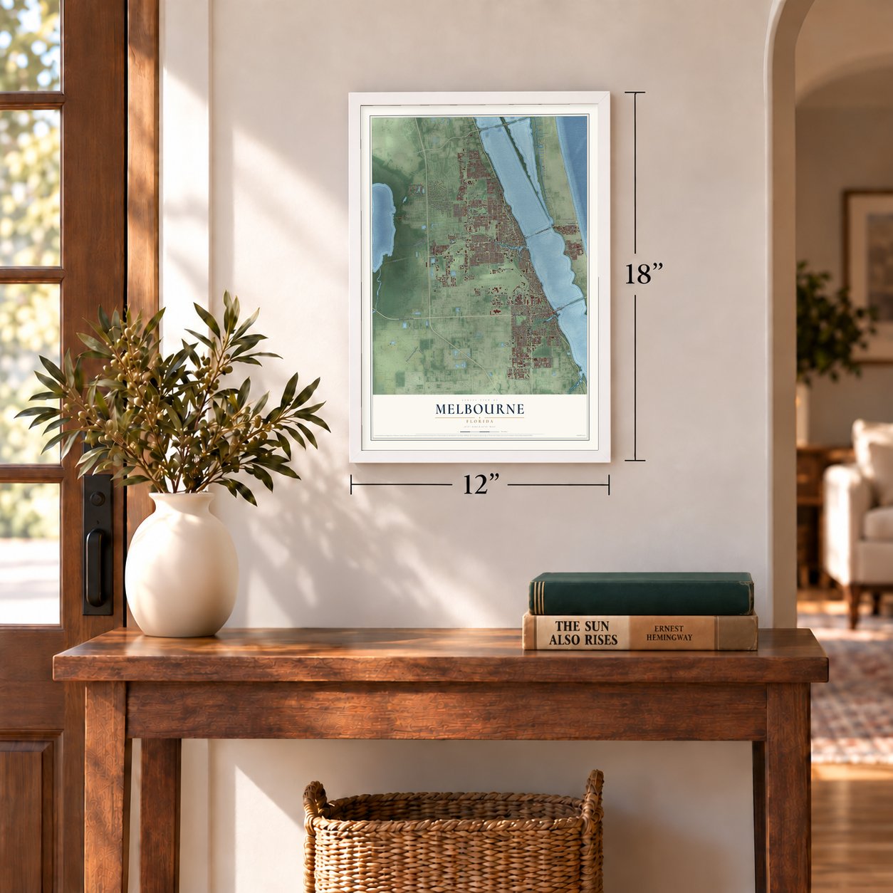
12" x 18" Archival Matte Print
A Map of Home. A Work of Art.
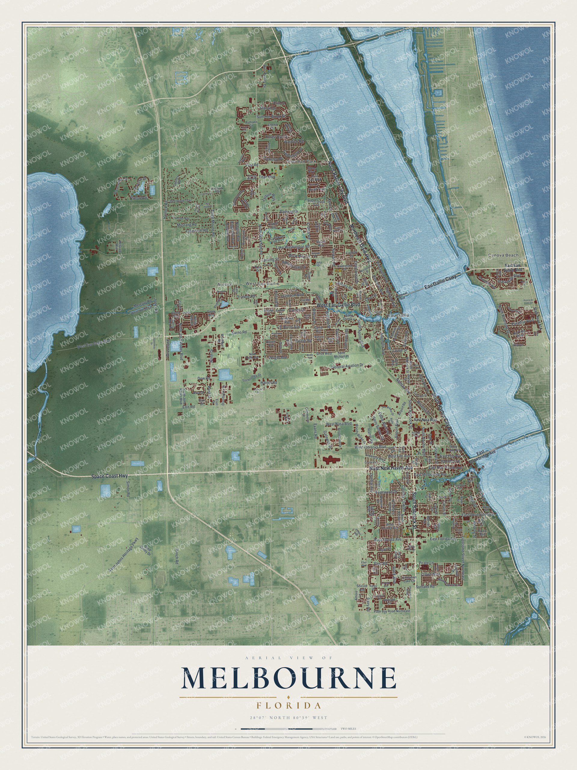
Explore Melbourne, Florida from a whole new perspective. Created using aerial imagery and detailed geographic data, this map captures Melbourne building by building, with labeled streets, familiar landmarks, and shaded topographical relief that highlights the natural contours of the landscape.
Combining modern data with the timeless character of a vintage atlas, this map is just as interesting up close as it is beautiful on the wall. Whether you grew up in Melbourne, spent memorable years there, or call it home today, this unique map is a great way to celebrate a place that means something to you. Zoom in on the preview to look for your street, and then order a print to put your memories on the wall.
Three ways to hang it

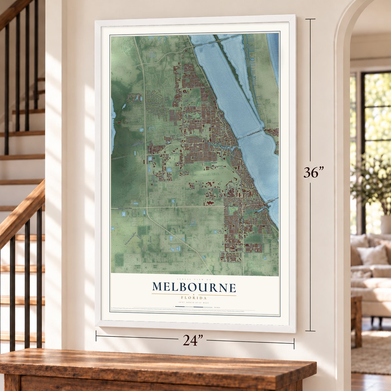
Unframed archival matte, a black wood frame or a white wood frame.
Up close
Geography Worth Displaying
This map was created using accurate cartographic data and authoritative geographic sources, including the U.S. Geological Survey (USGS) and FEMA. The map brings together terrain, waterways, roads, and building detail. The majority of the streets are labeled, houses are accurately depicted, and the topography is derived from government sources. Combining local data with carefully composed color and shading leads to this beautifully detailed Melbourne artwork for your wall.
Rather than simply showing street outlines, we’ve included as many of the street names as we could reasonably fit on the map while keeping their names legible. Zoom in on the high resolution preview to see exactly what’s on the map. We truly set out to create a statement piece for anyone who loves Melbourne. So whether it’s for you, or a gift for someone you love, we hope this map of Melbourne brings back fond memories.
Explore the full map of Melbourne, Florida and read about the local places it shows.

About Melbourne, Florida
Melbourne is a city of 84,678 people in Brevard County, on the Indian River Lagoon along Florida's Space Coast. Settlers began arriving after 1877, when the place was known as Crane Creek, and three of them, Peter Wright, Balaam Allen and Wright Brothers, were Black freedmen. The town later took the name Melbourne to honor Cornthwaite John Hector, the first postmaster, an Englishman who had spent years living in Melbourne, Australia.
Melbourne's first school went up in 1883. Two years later the town counted 70 residents, and that same year worshipers organized Greater Allen Chapel African Methodist Episcopal Church, a congregation that is still active today. In 1919 a fire wiped out most of the original downtown along Front Street, so the business district was rebuilt west of U.S. Route 1.
- Mammoth bones on Crane CreekC. P. Singleton, a zoologist from Harvard, found mammoth bones on his property beside Crane Creek during the 1920s. He asked Frederick B. Loomis, a paleontologist from Amherst College, to help, and Loomis uncovered a second elephant with a flint tool lying among its ribs. The same layer of earth held bones of mastodon, horse, ground sloth, camel and sabertooth cat, evidence that people hunted here at the end of the last ice age.
- Navy pilots from 1942In late 1942 the Navy opened Naval Air Station Melbourne, where new Navy and Marine Corps pilots trained during World War II. The program closed in 1946, and most of the station's land is now Melbourne Orlando International Airport.
- A college for the space ageDr. Jerome P. Keuper started Brevard Engineering College in 1958 so people working in the space program could continue their education, and its first classes met in leftover Navy buildings at the airport. It became the Florida Institute of Technology in 1966. Its first Black student, Julius Montgomery, had already broken the color line at RCA's lab at Cape Canaveral, and in 1969 Melbourne voters made him their first Black council member.
- Two towns become oneEau Gallie was founded in 1869 by William Henry Gleason, who had served as Florida's lieutenant governor, and its name is often said to mean "rocky water" for the coquina rock along its shore. His house still stands on Pineapple Avenue. In 1969 voters in Eau Gallie and Melbourne agreed to merge, a second vote kept the Melbourne name, and the city doubled in size, which is why it has two downtowns.
Find your street
Names on the Melbourne map
Every name below is printed on this map. Look for your street, your school, the park where you played, or the pond down the road.
Places and landmarks6
- Wickham Park
- Aurora
- Canova Beach
- Eau Gallie
- Sherman Park
- West Eau Gallie
Streets and roads286
- North Harbor City Boulevard
- Northeast Dixie Highway
- South Harbor City Boulevard
- West New Haven Avenue
- South Babcock Street
- Space Coast Highway
- West Eau Gallie Boulevard
- Eau Gallie Causeway
- Riverview Drive
- East Florida Avenue
- West Fee Avenue
- North Wickham Road
- Croton Road
- Sarno Road
- Lake Washington Road
- Parkway Drive
- Dairy Road
- West Nasa Boulevard
- Aurora Road
- South Apollo Boulevard
- Turtle Mound Road
- Post Road
- East University Boulevard
- Pineapple Avenue
- Lipscomb Street Northeast
- Saint Johns Heritage Parkway
- West Hibiscus Boulevard
- North John Rodes Boulevard
- Avocado Avenue
- North Riverside Drive
Show all 286 streets
- Hickory Street
- Stewart Road
- East Melbourne Avenue
- West Florida Avenue
- General Aviation Drive
- Simon Road
- Harlock Road
- Highland Avenue
- East New Haven Avenue
- Province Drive
- Evans Road
- North Apollo Boulevard
- Summer Brook Street
- Airport Boulevard
- Country Club Road
- Eber Road
- Stack Boulevard
- East Fee Avenue
- Oceanside Boulevard
- Ellis Road
- Pirate Lane
- Edgewood Drive
- North Drive
- Lansing Street
- Gateway Drive
- Jones Road
- Oak Street
- Magnolia Avenue
- Ranch Road
- Harry Sutton Road
- Holland Street
- Leewood Boulevard
- Creel Street
- Forest Run Drive
- Mariah Drive
- Eddie Allen Road
- Nieman Avenue
- Paradise Boulevard
- Aria Drive
- Grant Street
- Lakemont Road
- Titan Boulevard
- Trimble Road
- Appalachian Drive
- Laurie Street
- Holy Trinity Drive
- Leisure Way
- West Drive
- Wisteria Drive
- Mustang Road
- Locksley Road
- Kingsmill Avenue
- Erin Lane
- Audubon Drive
- Cedarwood Drive
- Nobility Avenue
- Empire Avenue
- Wright Avenue
- Mercury Road
- Groveland
- Canterbury Lane
- Fatzler Road
- Crown Boulevard
- Harris Road
- Ironwood Drive
- Quail Trail
- Dunbar Avenue
- Harper Road
- Monroe Street
- Main Street
- Misty Way Lane
- Colony Drive
- Tupelo Drive
- Dow Road
- Ballard Drive
- Burns Avenue
- Warwick Road
- Kent Drive
- Sunlake Road
- Garfield Street
- Stafford Drive
- Carver Street
- Wilson Street
- Rio Lane
- East Strawbridge Avenue
- East Eau Gallie Boulevard
- North Babcock Street
- Rouen Avenue
- Saint Michael Place
- Preservation Circle
- Palm Bay Road Northeast
- Deerwood Trail
- Thomas Barbour Drive
- Mount Carmel Lane
- Brentwood Lane
- Sand Gulley Drive
- Distribution Drive
- White Oak Circle
- Poseidon Way
- Espanola Way
- Palmetto Avenue
- Egret Drive
- Spring Oak Drive
- White Heron Lane
- Rio Villa Boulevard
- Harvard Circle
- Pga Boulevard
- Ruthann Circle
- Woodsmill Drive
- Pine Street
- Carlson Circle
- Silver Palm Avenue
- Stan Drive
- Country Road
- Canopy Drive
- South John Rodes Boulevard
- Woody Burke Drive
- Cinnamon Lake Circle
- Caribbean Isle Boulevard
- Villa Espana Trail
- Lowell Circle
- Commerce Drive
- Broadband Drive
- Bryan Street
- Ixora Drive West
- Colonial Drive
- South Fairway Drive
- Lime Drive
- Talon Way
- Palmwood Drive
- West Cornell Avenue
- Technology Drive
- Park Avenue
- South Vassar Street
- Watkins Drive
- Airport Road
- Comanche Avenue
- Vesta Circle
- Primula Lane
- Slone Boulevard
- Tree Line Boulevard
- New York Avenue
- Sand Dune Lane
- Lynn Avenue
- Washburn Road
- Butler Street
- Club Trail
- Andrews Avenue
- Sierra Street
- Hanson Avenue
- Rustic Way
- Elena Way
- Cayman Drive
- Prospect Avenue
- Snicole Avenue
- Cibola Drive
- Jolena Drive
- McGraw Avenue
- East Drive
- Amore Lane
- Dijon Drive
- Race Street
- Easy Street
- Spain Avenue
- Dawn Drive
- Sarno Acc
- Sweet Oak Drive
- Zephyr Lane
- Wiley Avenue
- Lucille Lane
- Steele Street
- Amber Court
- Lewis Street
- Dusa Drive
- East Nasa Boulevard
- Luminary Circle
- Crescent Drive
- Saddle Brook Drive
- Atlantis Road
- Eldorado Way
- Forest Creek Drive
- Estancia Way
- Sanderling Drive
- Arnold Drive
- Cll del Mar
- Commodore Boulevard
- Masterson Street
- Joe Walker Drive
- Willow Bend Drive
- College Wood Drive
- Alicia Lane
- Cindy Circle
- Brothers Avenue
- Stewart Avenue
- Bennett Lane
- Rolling Rock Drive
- Wallace Avenue
- Hammock Trail
- Laura Baugh Drive
- Beck Lake Trail
- Plummer Circle
- Scenic Drive
- Cronin Avenue
- Burr Street
- Lorelei Avenue
- Cape Palos Drive
- Buick Avenue
- Julia Drive
- Rally Road
- Tabitha Court
- Range Drive
- Hoag Avenue
- Sunset Drive
- Misty Oak Drive
- Byrd Street
- Eber Boulevard
- Montreal Avenue
- Lorna Drive
- Cypress Avenue
- Woodlawn Circle
- Marcello Drive
- Central Boulevard
- Arden Circle
- Thrush Drive
- Clarke Avenue
- Negal Circle
- Rivermont Drive
- Ponce de Leon Drive
- South Main Street
- Bulldog Boulevard
- Connors Cv
- Windrift Drive
- Nelson Avenue
- Wellington Road
- Speedway Drive
- Knight Avenue
- Algonquin Drive
- Windham Drive
- Thistle Drive
- Monarch Street
- Blue Bird Boulevard
- Merion Drive
- Tallpine Road
- Bush Drive
- Fair Point Lane
- Green Oak Drive
- Lytton Road
- Emerald Drive
- Mandys Court
- Painted Bunting
- Cedar Drive
- Hurley Drive
- Bridle Path
- Peel Street
- Huff Court
- Sea Avenue
Names are listed as they appear on the printed map. Zoom into the product photos to find them.
The art of mapping a place
How This Map Was Made
Real places. Remarkable detail. Discover the layers that turn geographic data into a map of home.

The view from above
Aerial imagery reveals the character of the land: woodland, open fields, and the patterns of a place.

The shape of the land
Elevation data brings hills, valleys, and subtle changes in the landscape into view.

The details of home
Roads, waterways, and building footprints come together to make the map feel unmistakably local.

Geography becomes art
Considered color, shading, and typography bring the layers together in a map made for your wall.


Process illustrated with Mendon, Massachusetts. Aerial imagery: USDA NAIP. Terrain: USGS 3D Elevation Program. Map details and finished artwork: KNOWOL.
The Details
About This Print
Choose an archival matte print, or a black or white Ayous wood frame. The archival matte print is unframed.
Select your size and finish above to see the matching product image and price.
Materials & Craftsmanship
A contemporary map with the character of a classic atlas, printed on archival matte paper. Optional frames are made from Ayous wood.
Your printed map does not include the watermark shown in the full-map preview.
Shipping & Delivery
Free shipping within the United States. Every print is made to order in the USA.
Buying a gift? Add a note in your cart and we'll include it. We never put prices in the package.
Prints ship within 2 to 3 business days. Allow 7 to 10 days total from ordering for delivery. Timing may vary during holidays or periods of high order volume.
Read our shipping policy.
Returns and damaged prints
Each print is made to order. Change-of-mind refunds are not available after production.
If your print arrives damaged, misprinted or incorrect, contact support@knowol.com within 30 days of receiving it. Include your order number, photos and a description of the issue.
Read our full refund and replacement policy. For questions about your order, email support@knowol.com.
Find your town
Looking for another city?
Find a map of home in our Florida collection, or any town in the country.
Nearby
Maps of towns near Melbourne
Know someone from one of these towns? Their map makes a great gift.
 Melbourne Village
, Florida
From $39.99See the map
 June Park
, Florida
From $39.99See the map
 West Melbourne
, Florida
From $39.99See the map
More maps nearby: Indian Harbour Beach, Palm Shores, Indialantic, Satellite Beach and Melbourne Beach.